Saturday, November 4

Molesworth- Part 1; The Road In

Real-time

Well, no need to tell you I'm behind again in my blogs, but I thought I'd do the Molesworth blogs first because I know there are a few people eager to read about our visit to the Crown owned high country Molesworth Station; the largest farm in New Zealand at 180,787 hectares.

Under the stars
The Molesworth Station/Acheron Road has been on our 'must do' list ever since we started this journey and in fact we have been foiled in our attempt to drive it three times over the last couple of years. Being a high country road and subject to weather, especially during winter, the road is only open from Labour Weekend in late October through to Easter weekend/April each year. 

The road was closed due to high fire risk the first time we had it planned, the 2nd time we had to drive straight past to attend a family gathering and the third time the Kaikoura earthquake closed the road. 

We very nearly didn't make it this time either when a flood washed out the approach to the Clarence River Bridge at the Hanmer Springs end of the road. But, as luck would have it we (read I), only wanted to join the dots and we'd made it to the Clarence Bridge a couple of months ago while in Hanmer. That was a fluke as well, you may remember, we delivered a car to the bridge for a couple of kayakers we met in the snow out the back of Hanmer. And as you'll find out in due course there was very nearly a fourth time.

Anyhoo enough of my prattling on, let's get on with the road trip, we had 100kms to travel down the Awatere Valley and seventy of them were on gravel. Caravans, buses and vehicles over 7 metres aren't allowed on the actual Molesworth/Acheron Road but you can take them to the Cob Cottage DOC campground at the start and explore the road in your tow vehicle or 'toad'.


World famous Marlborough vineyards line both sides of  road for the first 30kms and then the brilliant yellow of the invasive broom takes over for a short time...


...until the seal runs out and we decide to stop for a very late lunch before we tackle the gravel. Blairich Reserve is one of two designated campsites along the valley, it's beside the river with a basic toilet and several areas to park. Although it was more like a track through the willows down to the river (David had some fun and games turning the rig around when we ran out of track) but in the end it was very pleasant in the cool shade under the brilliant green of the new willow leaves.


The road follows the Awatere River for most of the way, as we weave our way into the high country, climbing over bluffs, winding around hills and then dropping down into small valleys where farm buildings are tucked into sheltered corners. Occasionally we get a reprieve from the dust where the road has been sealed as it passes by a farm homestead or there's a sharp climb. Cattlestops are a regular occurrence; a good keen eye is needed to watch for wandering stock (or kamikaze sheep who burst out from under the matagouri scrub just as we're passing).


There are spectacular views of the river and rapids flowing through this gorge...


...as we navigate through a particularly narrow section of the road high above, where it looks like a slip has taken some of it out at some stage (perhaps the 'quake?); the rock slide reaches right down to river below.


Other than the constant dust swirling behind us...


...the road is generally in good condition, although having said that, there were a number of rough patches. 


I was excited to see dozens of Marlborough Rock Daisies clinging tenaciously to the cliff faces along the road, most of them with buds ready to burst into flower. Marlborough Rock Daisies, while plentiful in their habitat are only found in Marlborough.


After what feels like forever (for David anyway), we reach the halfway mark- it's 54kms to the Hodder Bridge which was built about 80 years ago and has been recently re-strengthened.


The bridge crosses the Hodder River (which flows into the Awatere) and has its headwaters in the Chalk Range, near Mt Tapuae-o-Uenuku, New Zealand's tallest mountain (2885m) outside the Southern Alps. 

Tapuae-o-Uenuku is a sacred mountain to Maori and is the prominent snow capped mountain that can be seen from many places as you travel along the coast in Marlborough. The mountain was shrouded in cloud on our trip down the valley but look, I prepared one earlier for you (actually later, I took it on the way out six days later). Mt Alarm(2877m) is in the middle and Mitre Peak (2621m) on the right (no not THAT Mitre Peak, this one is actually taller).


The second designated camp site in the valley is on the southern side of the bridge; a large flat grassy area with a nearby long-drop loo. 


We continue on, passing a few abandoned homesteads and crossing numerous smaller rivers and streams that feed the Awatere. 


I can see that the road winds it's way up the side of the hill ahead of us, a hill that actually turns out to be a mountain, although Mt Upcot is pretty small at 1031m.


This section of the road is full of corrugations and a more than steady climb.


It's very narrow and rough and I'm getting tossed about inside the cab as I try to take a photo...


And it's a long way down as we climb higher and I attempt to take a shot out the window...


Until we finally reach Upcot Saddle, where we stop and check inside the van (a first for us). It's all ship-shape and not for the first time, David comments on how good the suspension is in the 5th-wheeler, it seems to travel much easier on rough roads than the ute and it's occupants who feel every corrugation and pothole.


I walked back to a vantage point overlooking the road we've just come up to take a photo.


We're now in 'big country' with gigantic hills and deep valleys and we still have 30kms to travel. We pass several grand entrances to high country stations and across the valleys can see farm buildings, shelter trees and the brilliant green of cultivated land below the rugged slopes of the ranges.


It's about now that we're both starting to feel a little dust weary and it seems the distance left to travel isn't getting any shorter. We're averaging about 35-40kph and as I always say, one gravel kilometre feels like two, and by my reckoning we still have 40kms to go!!


The bridges are also getting a little more rickety...


Finally we reach a gate and the good people of DOC must know how we feel, they've given us a kilometre reading just to rally us along. Not far now, just 20kms....I mean 10kms. You can start to breathe easy again David (literally as well), we're nearly there. 


And look there's snow on the mountain ahead of us...


We're in the mountains now, the Inland Kaikoura Range now backs the Awatere River and the scenery is stunning.


We're passing through Muller Station, a farm that borders Molesworth on many boundaries. And the river is still a prominent feature, although smaller and with hundreds of brilliant green willows lining its banks. What a spectacular sight they would be in autumn. 


Finally we arrive at the gate into Molesworth Station, exactly four hours after turning onto the Awatere Valley Road (that includes all snack breaks and photo stops).


Just a few metres further on we catch our first glimpse of the historic Molesworth Cob Cottage. This will be our backyard for the next few days, the DOC campground surrounds the cottage.  


To be continued.... Part 2


Thursday, November 2

Out of Range

Real-time

In case you hadn't noticed, we've been off the grid and out of internet range for the last week, camped beside the historic Cob Cottage on Molesworth Station- 100kms down the Awatere Valley, inland from Blenheim. 


That 100kms included 70kms of winding, dusty gravel road. And that was just to the camp. We then drove the Molesworth Road to the Clarence River Bridge, and back again (in the ute only); adding another 120km of gravel to the tally. Then after a suitable break it was back up the valley to civilization, and a grand total of 260kms of gravel and just 60kms of seal. 

I can tell you something for nothing, there is dust in every nook and cranny imaginable and that's just us, you should see the rig! And guess what? Not one drop of rain in six days to dampen it down!

We had an fantastic time and I have so many great photos and some interesting stories to tell you about. Very soon. For now, it's a little more R&R, replacing the dust with a little salt spray.

NB- there is no through road to Hanmer Springs at the moment, the bridge approach at the Clarence River has been washed away in a recent flood. 

Tuesday, October 24

Totaranui- Bird Antics

Catch-up

Let's see if I can keep the typing (talking) to a minimum on this one, I still have another Totaranui blog to post and I don't want to get too far behind again. 

As I said previously, Totaranui (Abel Tasman National Park) is a great place to spend some quality birding time but the trouble is, if you're a photographer and a birder, you end up with screeds and screeds of photos to process, and way too many you want to share. I managed to whittle them down to these few; some cute shots, some fun shots, a couple of unusual shots and a sad one too.


I finally found some weka chicks during the second week, in fact after only seeing a couple of chicks during the first week, they were suddenly everywhere, although the parents do keep them hidden in the bush most of the time. 

It's easy to spot a weka who has chicks; if they find food while foraging out in the open they suddenly take off, running very fast (they are comical to watch), making a beeline for the bush, clucking loudly. Not a great strategy if you don't want predators to find your chicks I would have thought.


A few weka head down to the beach very early to check out the overnight tide lines, weaving up and down to the water and round and round in circles along the beach like some drunken sailor. It was cute to find adult footprints with tiny chick prints running alongside one morning. But it was also disappointing to find dog footprints one day. Dogs are not allowed in the Park but obviously someone thought the rules didn't apply to them.


I found this older Weka Chick standing out in the open all by himself. He suddenly decided he was out of there and ran off calling loudly for Mum 'Arrrggghhhh.....she's after me, she's after me, heeelp!!'  (and my settings were not ready for his quick departure).


This has to be one of the most unusual photos I have taken of a bird (and now a favourite). An acrobatic (pole dancing someone suggested) Kereru/NZ Wood Pigeon out to get the tastiest Tree Lucerne shoots at the end of a very thin wispy branch. They are very versatile and agile birds for their size but this is something else.


I was walking back to camp when I thought I saw some paper caught in a bush. It wasn't until I got closer that I realised it was a Kereru hanging upside down. It was so absorbed in hanging on while stripping off the tastiest shoots that it didn't take any notice of me as I crept closer. When it eventually spotted me it let go and hit the ground with a thump, before flying off. 


The pigeons were often the subject of my lens, there were just so many of them about. Here they are; chasing each other, stretching for shoots and flying off in the wrong direction when I was trying for some flight shots.


Even though they are quite slow flyers they tried my patience many times as I attempted to get those flight shots.


And sometimes they just played peek-a-boo...


Here are a couple of comparison shots- one taken in the shade and the other in the sun. While there seemed to be some slight variations in colouring amongst birds, you can still see how iridescent the head and in particular the breast feathers are here. That green is quite spectacular and stands out like a sore thumb when you're scanning the trees for birds.


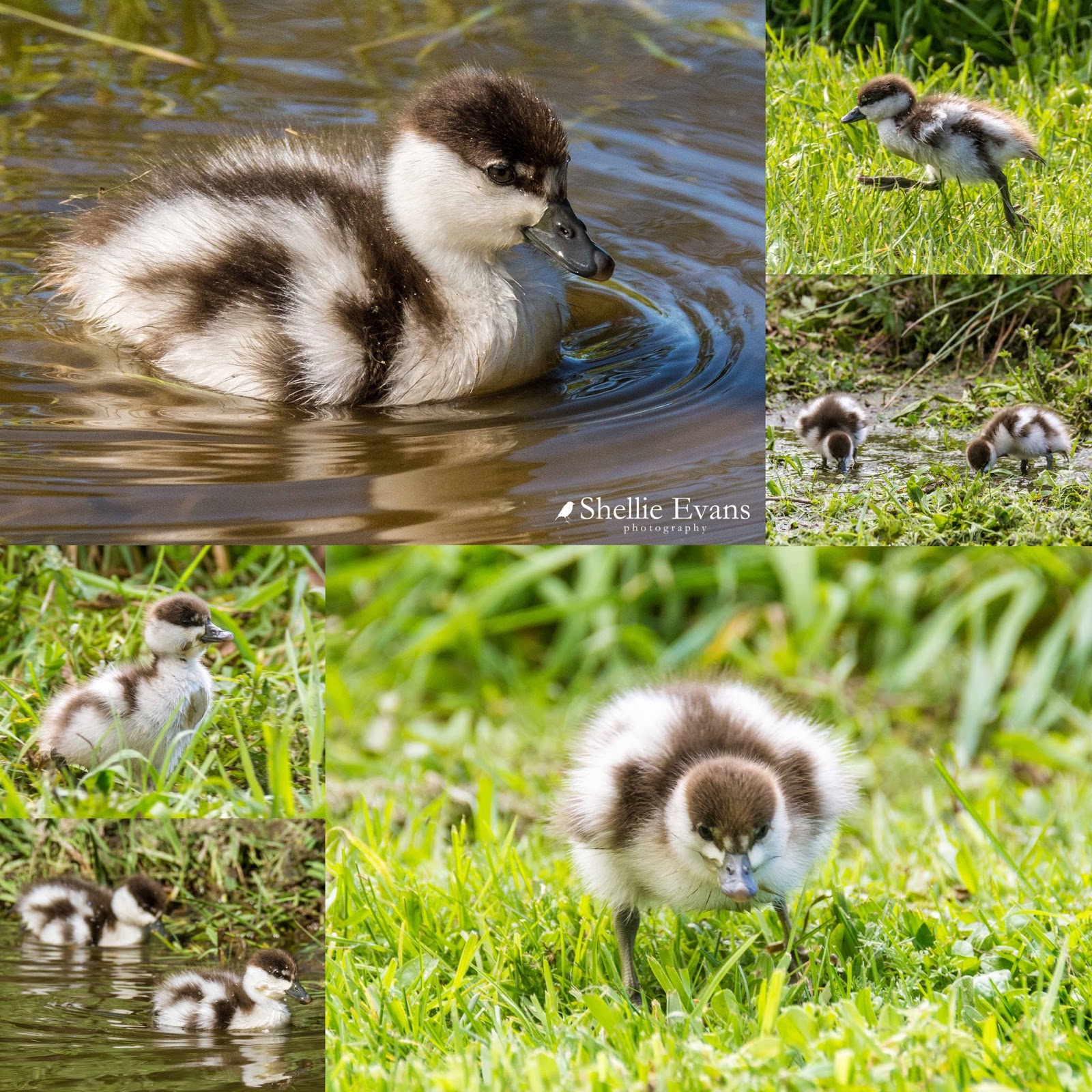
Spring wouldn't be spring without ducklings and especially our native Paradise Shelduck ducklings. Here's Mum (one of the few native females that are prettier than their male counterparts)


And Dad (who is still quite handsome)...


And their four gorgeous fluffy ducklings... 


It's hard to believe that this isn't a pond they're swimming in, it's a small depression that has filled with water (so much rain over winter) alongside the 'Grand Entrance' trees. They also swam in another couple of large muddy potholes on the edge of a track on the other side of the trees. 


And it's where I headed each time I wanted to check in on the family. Although they spent a lot of time at the pools they would also do a loop each day, waddling all the way up to our campsite bay, cutting through and then heading back along the estuary edge to their pools; quite a feat for 4 tiny ducklings. 


I say 4 but it wasn't long before it became 3 and then 2 ducklings. Anyone who has been following my blog knows I'm a sucker for ducklings and it usually ends in heartache so I try not to become too attached to them.  But how can you not resist these cute bundles of fluff?  

"Please will you just sit down Mum!" says this duckling who reminds me of the 'Joker'. Check out his 'grin' (click to enlarge the photo), it's a dirt line from dabbling in the pool.


I was sitting on the van steps one afternoon when the family came waddling through, now with just the two ducklings. I reached inside to get my camera and went to take a photo just as a weka came racing out from underneath the van and grabbed one of the ducklings. I managed to click off a couple of shots as I raced towards the melee waving and shouting (excuse the photos, once again I wasn't expecting so much action). Here you can see the duckling in the Weka's bill,  Mum was quickly after it, trampling the 2nd duckling as she chased. 


Dad was a bit slow off the mark, the weka still has the duckling but dropped it soon afterwards. Weka are known to predate ducklings and I've also been witness to one stalking a Pukeko chick at Lake Kaniere on the West Coast. 


The family departed at a very fast pace down the estuary track, quacking and cheeping to each other. Later in the evening, when I checked in on them at the pools, there were still two ducklings.

But the next day they were down to one. It's a tough life being a duckling, it's no wonder they usually have so many.


Saturday, October 21

Abel Tasman Coast Walk- Awaroa to Totaranui

Real-time (although we have moved on from Totaranui)

We have visited the Tasman Bay area and the Abel Tasman National Park numerous times over the last 4 years, stopping for extended stays at Kaiteriteri, near the southern end of the Park and visiting the Golden Bay end a couple of times also. Although we've not walked the complete 60km 3-5 day  Abel Tasman Coast Great Walk, we have walked the Medlands Bay to Anchorage section on a previous visit after doing a boat tour right along the coast to Totaranui.

This time I was thinking that David could run me to the Awaroa Inlet in the boat and I'd walk the 7km section from Awaroa back to Totaranui but in the end we decided we'd drive to the Awaroa carpark and I'd walk from there. The carpark is at the end of a very narrow, winding road, the last time we explored the road we came across a rental motorhome that had slipped off the road. There are a number of holiday baches and a few lodges on the far side of the inlet near the beach, the carpark is where owners and visitors leave their vehicles. They then either use dinghies to cross at high tide or walk across (or around) the estuary at low tide.

From the carpark I crossed the estuary to that tiny island and then headed towards the track entrance which is around that little finger of land and across to the far left. The Awaroa DOC hut can be seen on the shore on the right. Trampers cross directly from there to the track entrance on their way north.


The water, in places, was deeper than I'd hoped for but I'd commandeered David's socks off him at the last moment in case mine got too wet. I wasn't going to take my boots off; while it's lovely to walk on the sandy parts, much of it was sharp shells and mud. You can then spend half an hour trying to dry your feet and get rid of the sand between your toes before you can start on the track.

David waited until I rounded the island; can you see him above the dinghies? (click to enlarge the photo- use your back arrow to return to the blog)


He's taking a photo of me taking a photo of him! 


Walkers can cross the estuary 90 minutes before low tide and up to two hours afterwards, and as I neared the crossing point, I spotted a group making their way across from the DOC hut.


I decided to let them go ahead of me, that way I could take my time once I got onto the track proper and not have them breathing down my neck (and nattering away disturbing any birds). I wanted to walk down towards the beach anyway but decided not to cross over as the river got deeper towards its outlet. 

Awaroa Beach is world famous in New Zealand; it's the beach that over 40,000 Kiwis bought through a crowdfunding campaign when it looked liked it would be lost to private ownership once again, you can read about it here. There are also some lovely aerial photos of the inlet in that link too.


As I walked alongside the streams and channels that criss-crossed the inlet, I once again found dozens of shoals of whitebait fighting their way upstream against the current. As soon as they spotted me they turned tail and were swept downstream, only to turn and head back up over the same ground as I stepped back.


Someone else was keenly following their progress; a Kotuku/White Heron, and I'm guessing the same one that we were seeing in the Totaranui estuary on a regular basis.


The group of trampers hadn't made much progress, there was much laughter and squeals of surprise coming from them, some had taken their boots off and were struggling across the broken shells, while others that hadn't, had sunk to their shins in mud. A few other walkers were crossing in the opposite direction and having the same problem. 


I stayed with the white heron for awhile, waiting until they eventually disappeared up the track and then made my way to the track entrance where I met another two couples heading across the estuary. I guess low tide at the estuaries along the walk are always going to a bit of a bottleneck as walkers time their crossing to suit the tide. 


The first section of the track is a gentle climb over the inlet headland to Waiharakeke Bay, the wide and gravelled track was very easy going, passing through beautiful bush and running alongside two crystal clear streams, one exiting into Awaroa Inlet, then once over the top, the other running down to the beach. 

There's plenty of evidence of pest control in the Abel Tasman Park (and in many of the parks we visit)- wasp bait stations and stoat and rat traps on the ground but this is the first time I've seen this type of trap (below left). I think it's for possums, they'd climb up on the board and put their head in.....well, no need to give you any graphic details. The Abel Tasman Park has the added bonus of Project Janzoon to help with predator control, a privately funded trust, working in conjunction with DOC to restore the local ecology. And in case you're wondering; 'Janzoon' was Abel Tasman's middle name. 


Once over the headland I take a short detour to check out the Waiharakeke Campsite, it's tucked up in the bush just behind the beach. I decide to have my lunch at the picnic table listening to all the birdsong and watching the antics of a couple of tui chasing each other and anything else that dares to land in a nearby tree. 


After lunch I walk back to the track and out onto Waiharakeke Beach, there's no missing this entrance if you're coming from the other direction.


The group of trampers ahead of me have spread themselves out along the beach to sunbathe and explore. 


Awaroa Beach can be seen in the background here.


I carry on my way, up the stairs at the far end of the beach. It looks like the group will be here for awhile and I can get a jump on them. Perhaps this is as far as they'll be going and they'll pitch their tents in the campsite.


There's a short steady climb after the stairs and then the next section of the track follows a part of the rocky coastline around Ratakura Point. There are peeps of the ocean here and there and also a view across to Awaroa Head through a tangle of bush.

Photos clockwise- 1) Awaroa Head, 2&3) Punga/Tree Fern, 4) Awaroa Beach(zoomed in), 5) Bush Lawyer/Tataramoa flowers (a scrambling thorny native climber, with sharp backwards-curved hooks that grab and rip clothing and skin. Once it seizes hold of you, it doesn't let go, presumably the reason for it's English name.), 6) Nikau Palm


And then the view opens up to something more spectacular; Goat Bay, the next beach on the walk. The tour boat in the background is heading into Totaranui.


I step down from the rocky platform at the end of the track...


...and out onto Goat Bay beach where no one has gone before me (yeah right). There are obviously a few walkers in a hurry because I have the whole beach to myself.


I stop to say hello to a Variable Oystercatcher/Torea Pango, with leg bling that looks a might uncomfortable. Variable Oystercatchers are mostly all black in colour (I know, it used to confuse me too, 'variable' means, well, variable doesn't it, not all black, right?)  This is an intermediate morph adult (it was with an all black mate- haha no pun intended!). They are not to be confused with a South Island Pied Oystercatcher who looks similar but has distinct black and white markings with a white breast and underpants, and who is also a larger bird. 


I leave the oystercatchers to their foraging and carry on to the far end of the bay, to where the next section of the track begins up and over Skinner Point. The cloud formation certainly makes for some fab photos.


I put my camera in my pack (very unusual for me) for the next climb, it a steep steady haul, with many switchbacks. I wonder when I'll reach the top. This is a reasonably new section of the track. If you look at the photo above (click to enlarge), you can see two slips on the point; they wiped out the old track which was just a very short climb to that low section on the point. The new track enters the bush at the base and then does a hard left before weaving back and forward to the top which I think must be close to the left edge of the photo. From the top it's a steep descent down the other side with lovely views through the manuka of Totaranui below- can you see the 'Grand Entrance' trees?


Half way down I take a short side track to Skinner Point Lookout, it's where the old track used to pass by and thankfully they have kept this part open, who'd want to miss this fabulous view of Totaranui.


On my way back to the main path I watch as a water taxi arrives at the beach...


...and zoom in on a long line of trampers waiting patiently to board; the owners of all those footprints perhaps? 


Then it past the sign board and home to have a much needed cup of tea; 3hrs 30mins and 9.5km later (inclusive of all photo stops, snack breaks and up and down the inlet). Job done!