Catch-up
Continued on from Part 2
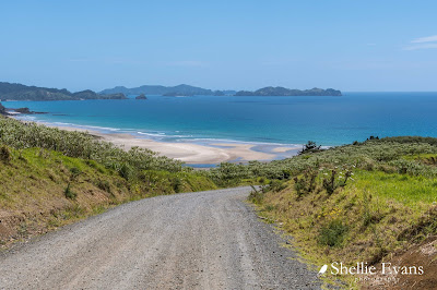
I had read about a camping site north of Kerikeri at Takou Bay, so we went for a drive to check it out.
 |
| Cavalli Islands on the horizon |
Towards the end of the gravel road, a steep rough dirt track dropped down to the edge of the Takou River estuary with what looked like the camping area beside it but with not a camper in sight.
We drove a little further on and parked on the edge of a stunning beach.
We had a wander along the beach...
...and explored the rocks and pools at the southern end of the beach.
Then made our way back to the ute parked on the dunes and started to head back up the track.
As we pulled away we saw another vehicle on the edge of the estuary; a man, his child and a pack of dogs going for a swim. He called out to us so we stopped. And that's when we found out that this was private land and hadn't we seen the sign at the top of the track near the small settlement. Oops! David apologised profusely and we high-tailed it out of there.
Actually, David had seen a sign but he thought it was for a side road that passed through the settlement not the one we drove down on. And I totally missed it, looking through my camera at the beautiful coastline in front of us. It would seem that the road has been closed to the public for a number of years so perhaps they open the camping area to locals & regulars over the height of summer. But it definitely wasn't open when we were there.
We next drove to Lake Manuwai, a manmade water reservoir which supplies Kerikeri's citrus & kiwifruit orchards and farmland with irrigation water. The lake is New Zealand's most northern lake holding trout and each year about 500 fingerlings are released by Fish & Game. Lake Manuwai is also used for whaka ama (outrigger canoe) training and racing.
And a Kerikeri public reserve wouldn't be complete without the obligatory colourful rooster strutting by with his girlfriend.
From the lake we headed out towards the coast again, 20kms down a very long and mostly gravel road, out past the Kerikeri Inlet, skirting around the edge of the Te Puna Inlet, out to the far reaches of the north side of the Bay of Islands, out along the Purerua Peninsula.
Finally stopping just before the road ran out where we were greeted- after all the farmland we'd been passing through- by the slightly surreal sight of a huge bank of beautiful pink & white roses.

The roses formed the carpark border for the Rangihoua Heritage Park and historic Marsden Cross Walkway, a kilometre long track that winds down the hill in front of us, passing a small wetland, then follows a short stream to Rangihoua Bay. Along the way there are numerous information panels which tell the life, times and loves of the local Maori and early settlers.
It was here on Christmas Day, just over 200 years ago, that Maori joined European missionary settlers including the Rev. Samuel Marsden, to celebrate the first Christian service in New Zealand. It was also here that the first European school was built and the first Pakeha child was born. Along with the information panels there are several metal map reliefs pointing out the historic sites.
This one has the names of all the visible islands in the Bay of Islands.
I was more interested in the beautiful park like grounds and private beach of this property along with their own tiny islands just off shore. The Landing has upmarket accommodation available in several secluded villas ($5,500 - $15,500 per night!) including one on the beachfront tucked around the corner of the hill in front of us.
This panel is interactive, there's a square cut in the panel and the view is of the Rangihoua Maori Pa on top of the hill across the valley.
Don't forget to click the photo to enlarge if you'd like to read the information (hopefully).
Towards the bottom of the walk many of the panels are about the people, both Pakeha & Maori who lived and worked at the Mission.
Once in the bay there are more panels showing the layout of the settlement and also a memorial to the settlers.
Just a couple of weeks ago, the bush on the small bluff in this photo was set on fire at night by some idiots, luckily a boat that was anchored in the bay, saw what was happening and was able to call for help.
And a track through the bush beside the Cross leads to another memorial...
...erected by the descendants of Thomas Hansen, the first European non-missionary settler at Rangihoua.
We head back to the carpark after a very interesting and thought provoking visit to Rangihoua Bay.


