Showing posts with label Dog Kennel Corner. Show all posts

Thursday, December 10

A Trip Over MacKenzie Pass

Fed up with the wind, and dust blowing around our Tekapo camp, we headed out on another day trip exploring the back country.


Our destination is MacKenzie Pass, a road that we were intending to do the last time we were in the area. But we were side tracked on the day, a very long side track as it turned out. We carried on past the end of the MacKenzie Pass Road and off down a 60km gravel road to Lake Benmore.

I spot an Angler’s Access sign on a farm gate not far before we turn onto the pass road and we decide to check for trout in the river, which is at the end of a farm track. David stalks a large Brown upstream while I take a few photos of the farm bridge and crossing. There’s another vehicle parked near the river and a courtesy notice in his front window telling us he’s fishing upstream which means, if David had been fishing, it is angler's etiquette not to encroach into his fishing space.


We leave the fishing for another day and head back out and onto the MacKenzie Pass Road. As you can see the pass isn’t actually that high, it’s more of a dip in the hills of the Dalgety Range.


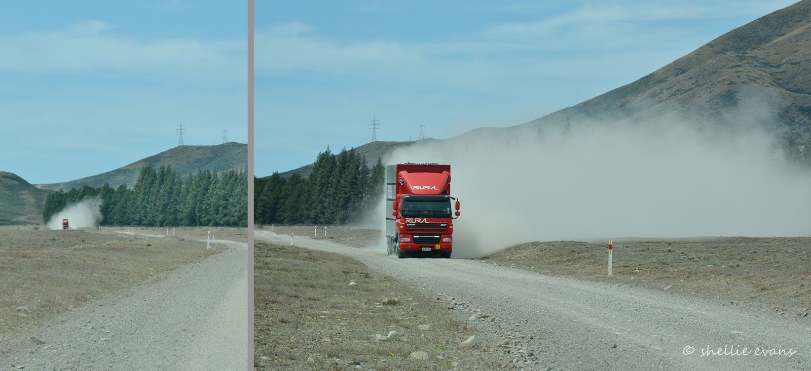
It’s hot, dry and dusty and the wind is still blowing a gale. Off in the distance we can see a very large cloud of dust fast approaching; a stock truck comes thundering towards us, a huge dust cloud sweeping along behind it. We move off the road and wait until it’s passed before continuing on and thank God that the wind is blowing the dust away from us.

The James MacKenzie Memorial is located at the bottom of the pass near the MacKenzie River, which is more a dribble than a river, as are many of the waterways in the MacKenzie basin. The memorial marks the spot where James MacKenzie was captured after rustling 1000 sheep.

In 1855 James Mackenzie became one of New Zealand’s most enduring folk heroes. On 4 March he was caught in a pass in the upper Waitaki River basin with 1000 sheep that had gone missing from the Levels station, north of Timaru.
While Mackenzie was in possession of the sheep, the tracks of several other men were visible in the vicinity. MacKenzie denied the theft, claiming that he had been hired by John Mossman to drive the sheep to Otago. After escaping he walked 160 km to Lyttelton, where he was recaptured on 15 March. In April he was found guilty by a Supreme Court jury and sentenced to five years’ hard labour. 
MacKenzie escaped from his road gang in May and again in June 1855, for only a few days each time. Subsequently he was placed in irons and watched carefully. In September a new resident magistrate at Christchurch investigated the case and found flaws in both the police inquiry and the trial. As a result MacKenzie was pardoned in January 1856. He probably returned to Australia, but nothing certain is known of his later life. He left his mark on the South Island high country, though. The significance of the pass where he was found with the sheep, and of the pastoral country it led to, were quickly appreciated by pastoralists. The region was subsequently dubbed the MacKenzie Country.
MacKenzie’s exploits won him the admiration of those on the margins of society. He was a hero to many would-be farmers of small means. Those who resented the power of wealthy landowners also identified with him, and his rebellious spirit inspired many who did not fit easily into genteel Canterbury society. His pardon was popular in a frontier society still engaged in establishing its social and political norms. His life took on legendary proportions. His almost superhuman strength and his ‘fabulous’ dog Friday saw him held up as shepherd, drover and thief extraordinaire- From NZ History
The inscription on the memorial is in English, Gaelic and Maori (Maori in honour of Taiko & Seventeen, the Maori shepherds that tracked the flock to the Pass).


We leave the memorial behind us and start the short climb to the top of the Pass.


We were a little underwhelmed by the view from the top of the Pass, David especially so, he doesn’t even get out of the cab. We leave the crisp dry countryside behind us and head down towards Albury  and into the Waimate District. 


We still have the dust though and we spot a small cloud approaching us from a distance away. A motorbike appears around the corner as we pull over to let him pass. He waves and gives us the fingers……no he doesn’t. He’s indicating that there are two of them. We carry on and the second motorcyclist soon appears, we leave him to eat our dust.


We’re now on the northern side of the pass and driving through rolling green farmland dotted with lily white sheep instead of the dirty grey of the merino sheep of the high country. This family take their time crossing the road as they look for a way back into their paddock.


Albury and the main road are just a short 12kms away but there’s one more stop we want to make before we get there.


We’re going to surprise Dusty, if we catch him at home. The road we're on passes by the front gate of Albury Park Station. Albury Park Station is where we spent a night as guests of Dusty & Kate, parked in their backyard, over a year ago. We’d stayed the previous night on the road side beside the Mt Nessing golf course and as members, had played a game of golf the next day. You can read about those adventures by clicking the links above.

We turned into the drive and headed up to the house passing the historic farm buildings on the way.


Just as we round the last bend, we meet Dusty in his farm ute coming down the drive. He backs up and jumps out to greet us. Friday barks a greeting too (and now I know where her name came from, it’s just clicked- MacKenzie’s dog was called Friday), while a new pup springs and bounds about our feet, giving quick little nips at our heels and hands when we we're not looking. This is 9 month old Stanley (on the left) a new addition to the family and one that seems to have displaced Friday from her perch. Poor Friday, she would have had her nose out of joint when he arrived.

Of course the farm dogs just sit quietly watching the carry on. We had a lovely cup of tea and a catch up with Dusty. We met the station owners as well, they stopped by for afternoon tea with some lovely home baking. The family have farmed the area for over 100 years and their farms reach right back up to the top of the Pass. We left the family talking business and bid Dusty farewell, before continuing on our journey.


Before long we’ve turned back onto the main road and head for home passing through Fairlie before starting the gentle climb through Burkes Pass (a pass that’s not too much of a climb either). We’ve stopped to shoot the iconic church at Burkes Pass before but have not pulled into check out the interesting looking collection of buildings and old cars nearby. Burkes Pass was originally named Three Creeks, and was a wagon stop at the bottom of the pass. The area was first settled in 1859 and is now considered to be the gateway to the MacKenzie Country.

Three Creeks Arts and Craft is built on the site of the former Burkes Pass Hotel which burnt down in 1994. There’s a fascinating and eclectic mix of items from the past for sale along with art and craft from the present including a large range of macrocapa outdoor furniture as well as indoor rimu furniture. An old 38 Morris that used to deliver groceries at the pass sits beside the Coffee Caravan.


The craft shop and coffee cart are popular with tourists and locals alike. Remember the Edmond’s sign, the Four Square Man, well these and a huge number of other signs and symbols of yesteryear, merino wool products, clothing, accessories, decorative household ware, country themed goods, they are all displayed in the various buildings. It’s difficult to know where to look, there’s so much to take in. Photography wasn’t allowed in the main building where all the art, craft and giftware was located but believe me there was an amazing amount of cool stuff in there too.


There’s a treasure trove of recycled and old bric-a-brac in and outside this building. It must take the owners half the day to arrange the goods outside and take it in at the end of the day. I failed to see the mangle on the wooden gate until I was looking through the photos, otherwise I might just have been tempted to add that to our travelling road show.


Old wheels, machinery, it looks like nothing is ever thrown out. The owner was hard at work down the back fashioning more wooden products. What a busy and hard working man.


This very interesting business adds to the life of Burkes Pass and compliments the work that has gone into restoring and retaining this quaint little historic town of the MacKenzie Country. It’s a place well worth a visit when you’re next passing through the area.


And in case you’re wondering; yes I have worked some magic on a few of the photos. I have a new photo processing programme and love what I can do to some of my more rustic and vintage photos. The problem is it takes me twice as long to select the photos for a blog as I end up ‘playing’ with the many different options. I’ve had to be strong and not get distracted, keeping the the new programme for a select few shots only.


Not far from Tekapo (and home) I spot a flock of merino sheep in a paddock beside the road. This is not just another flock of merinos, this is a flock of very expensive merino rams.


Rams with a grizzled, wrinkly and weathered face, and a huge set of curved and clipped horns.


And this photo is fast becoming one of my all time favourites.


And not a lupin in site….


Thursday, June 11

The Road to Somewhere- Part 1

We began, what turned out to be an epic road trip, at Dog Kennel Corner, a relatively major junction just south of Burkes Pass. It’s a Y intersection with an overgrown island and a few trees in the middle. Haldon Road heads off across the flat tussockland at right angles to SH8 which carries on to Fairlie in one direction and Tekapo in the other.

I love that name; Dog Kennel Corner. Where else in the world, or for that matter New Zealand, would you find such a cool name. I wonder how many people drive past and think to themselves ‘How did that get it’s name’. I wonder how many drive past not even knowing the name of the corner. I wonder how many people know that there's a memorial hidden in the long grass under one of the trees. Not many I suspect.


Now I’m still left wondering. I wonder how a boundary dog managed to hold back a flock of sheep? Did he run up and down barking until they retreated? Was he chained up? If he wasn’t, why didn’t he run away? And how did he know where the boundary was? And who fed him!....

At first we were going to travel down Haldon Road, take a side road, cross over MacKenzie Pass, say hello to Dusty and Kate at Mt Nessing and travel home via Fairlie- a nice round trip. That’s McKenzie Pass, the dip in the range behind the ute wellside. But I’m sorry Dusty (if you’re still following my blog) we’ll have to say hello another time, we decided we’d go all the way to Lake Benmore at the end of the road.

We stopped at the next road junction and another familiar name; Hakataramea Pass. We last saw this name at the other end of the road, after we’d travelled Meyers Pass when we were staying in Waimate not long after we arrived in the South Island. Meyers Pass Road came out onto Hakataramea Valley Road (don’t you just love these names) not too far from Kurow. But Hakataramea Pass will have to wait for another day too.


No, our destination today was further on, much further on….


…60kms (you read right sixty, six o kilometres) further on down a long gravel road with just a few dips and bends in it. For the first 20kms or so it’s rough, scrubby conservation land and then the sheep stations begin, huge runs reaching far back into the mountains behind. Along the road edges, lined up in neat rows, are hundreds of rounds of baled hay.

Most of the MacKenzie Basin is dry and dusty, the annual rainfall is only 300-400mm and the temperature can vary from 40deg in the summer to minus 20deg in winter (minus 20! I think we’d need 3 diesel heaters to cope with that). During the hot summer months, there’s very little growth and with drought conditions most summers and lot of the land ravaged by rabbits, stockpiling hay and silage for stock, is the only way farming can survive in these harsh conditions.


Towards the end of the road we drive through Little Pass (Big Pass is up in the hills). A pass? A pass through a couple of hills, the tallest is 581 metres. I guess they wanted to at acknowledge something with a bit of height after all that flat land.


The road splits in two not much further on, a rough gravel road heads off to the right, the sign says Boat Harbour so we know we’re near the lake but we carry on straight ahead, we'll check the harbour out on our way back. We’re approaching the heart of Haldon Station, a 22,000 hectare high country station, with large stock yards, woolsheds and houses dotted about.


But the biggest surprise is when we turn and cross a bridge to find this gorgeous little school house tucked into the trees on the side of the road.


Haldon School reminded me of an American school house, with the patriotic flag flying outside, school bags hung on pegs and shoes lied up on a rack. The ‘fall’ colours helped as well. What a find, it’s these unexpected treats that I love to see on our travels.

While I was taking photos the door opened and two children came out, sat down on the step and put their shoes on. I asked them if it was lunch time and, yes it was, and they were going to play outside. One of the children told me there were 3 pupils, him and his sister and one other and they all lived on the farm station. From what I gathered, they do correspondence but have a teacher who supervises them. How cool is that, at least they had a school room to go to each day and for them it would feel like they were going to a proper school. I think that in times past this would have been a actual school, when there were a number of families with children on the station and other stations nearby.


While we were checking out Stony River which ran beside the school house, a huge bus full of people pulled out of the nearby farm gates, not something you expect to see this far out in the wops. We had seen the bus way back at Dog Kennel Corner when I was taking photos. We wondered where it was headed when we saw how long and deserted the road was. I think perhaps they were farm students of some sort on a tour, the bus headed further on down the dead end road, maybe to the next station.

And the reason we were checking out the river was because of the large number of trout that were in the shallows. At least 30-40 trout were making their way under the bridge and up to where a stream joined the river about 20 metres further on. Spawning trout! And they weren’t worried about us either, staying put and just juggling positions with each other most of the time.


My map book told me that there was a ‘Lookout Point’ further on down the road so we continued on, hoping to see the lake soon enough. We crossed more farmland with more hay bales but I knew from the low lying mist in the distance that we were getting close.


And then finally, we climbed a rise and turned a corner to find the lake right in front of us.


Lake Benmore looked absolutely stunning, a millpond with not a breath of wind. Lake Benmore is a manmade hydro lake, a drowned valley that was created in the 1960s by the construction of NZ’s largest earth dam, Benmore Dam. The lake covers approximately 75km² and we’re at the top north-east end of the lake, we have yet to visit the business end.

This might be our first sighting of the lake but it certainly won’t be the last, we’re going to be seeing a lot more of the lake and hydro canals that feed it in the weeks to come.


We carry on along the road which now follows the lake edge, I’m looking for Black Forest Cove where the lookout is- although it’s a pretty spectacular outlook all the way along.

We cross a cattle stop and a sign tells us we’re now in Black Forest Station, we drive a little further on and it looks like the road turns into a private road once we cross another bridge. There are 5-6 lovely homes dotted about near the entrance, all with drapes drawn. When I googled Black Forest Station later, I saw that the homes are all rental accommodation-
Black Forest Accommodation is a fabulous holiday destination with the most stunning scenery! Six self contained houses situated near the lakes edge, a Shearers Quarters and a Cottage, our accommodation is the key to a recreation paradise. Whether its Rest and Relaxation, Water sports, Fishing or catching up with friends and family you desire, visit our holiday houses website today!
What a great destination, although I bet those who book on-line would start to wonder where on earth they were headed when they start travelling that very long road. Perhaps some fly in.


We’re a bit reluctant to carry on along the private road, not wanting to intrude and not sure if the lookout is ahead of us or we’ve missed it, so we turn around and drive back to the water’s edge near the station sign to have some lunch. We sure do have our lunch in some amazing places.


The scenery is just as spectacular at lake level. We’re just that little bit late to catch the full autumn colours but at least the willows held onto some of their leaves to give me a little colour.


After lunch we head back out, stopping at a high point for one last look at the beautiful view. I bring out my landscape lens again, to try and capture the wider scene.


Back past the school house, the woolshed and the trout, back to the junction of the road and we turn left heading for Boat Harbour. Well, we’ve come this far we might as well check the harbour out, right? So off we head down another straight gravel road…..


...and it’s not long before we can see a power station in the distant, this is the top end of the lake and it’s where the hydro canals  from Lakes Ohau, Pukaki & Tekapo empty their contents into Lake Benmore.


We can’t reach the power station by road from this side of the lake, to get there we’d have to travel in from Twizel. But we could cross by launching a boat here at boat harbour and motoring over. This is known as the Haldon Arm Boat Harbour (that’s the main lake right at the end) and there’s a huge camping ground located on both sides of the arm.


A huge deserted camping ground that is kind of spooky; old corrugated iron smokers, soot covered BBQs, fire-pits, make-shift lean-tos, picnic tables & wonky chairs piled in corners, sites marked out and not a soul about. It’s a very large site and it’s hard to imagine that this place must be packed in the summer. And it’s so far from anywhere.

And not only that but when we crossed a footbridge over a deep stream, there was just as large a campground on the other side. We drove down one side of the arm (on the right above), it was very narrow due to the stream on the other side, we thought there might be a better view of the lake, but that’s all we could see (top right below) and then David had to back all the way back to get out.


This place must really be pumping in the season going by all the rules and regulations they have in place. I guess it would be the fishing that would attract most of the campers (click to enlarge if you're wanting to read the sign)


But all that was there to greet us were dozens of friendly fantails/piwakawaka, who flitted about very close, more so than usual; they’re obviously used to people and missing their camping buddies.


Still to come-
The Road to Nowhere- Part 2