Surrounding the historic Bushy Park homestead is the 89 hectare Bushy Park Tarapuruhi Forest which is a Forest & Bird Project.

The forest is a rare example of North Island temperate lowland forest. Lowland forests such as Bushy Park historically harboured the largest and most diverse communities of native and endemic plants and animals.
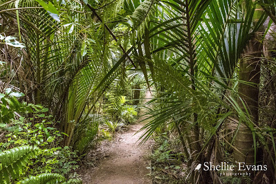
Bushy Park Tarapuruhi is unusual in that it survived (most lowland forest was clear felled) and it is relatively unmodified; there has been no logging or burning of the main forest. It was also fenced to exclude domestic livestock in the mid/early 1900s and is now surrounded by a 4.8km pest & predator fence protecting the forest and birdlife from introduced mammals.
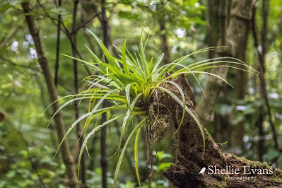 |
| Astelia epiphyte |
A male Hihi/Stitchbird on high alert. There's a feed station nearby & several males are trying to use it hence this one zipping about chasing them.
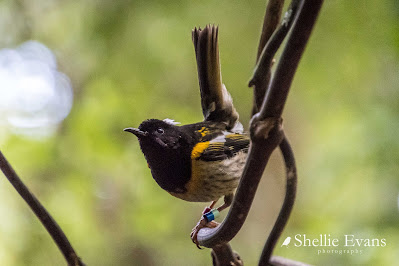
The stitchbird was both rare and poorly known about until the 1990s as few people had an opportunity to visit the single remnant population on Little Barrier Island. With careful management & conservation Hihi can now be seen at several protected sanctuaries.
The female Hihi/Stitchbird is hardly ever seen because the boys take over the feed stations. This one approached but was soon seen off (hence the blurry photo, you have got to be quick to capture them!).

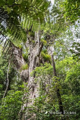
Ratanui the big rata tree of Tarapuruhi/Bushy Park is 36.2mtrs tall. Hard to believe that this rata started out as a small vine that grew up it's host tree and then sent out roots down to the ground, became established & slowly swallowed up its host (often a rimu). And look at all those 'widow makers', large clumps of the epiphyte astelia. Epiphytes growing on a tree that started life as an epiphyte.
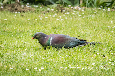
A big plump Kereru/Wood pigeon grazes on the homestead's front lawn. Our native pigeons often graze on the ground in large flocks, I once saw a group of around 50 or so birds in a paddock in Golden Bay. And if they're not grazing they are often being goof-balls, chasing each other, rolling over, doing mock attacks & aerobatics just off the ground.
There were so many Tieke/Saddleback in the forest, they were calling to each other, flying about & pulling apart rotting trees on the ground & scratching about in the forest litter but they are very hard to take a photo as it's so dark in the bush & they are so fast in amongst the tangle of undergrowth. So as I was checking out the homestead garden...

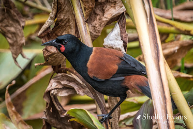
Tieke are endemic (found only in NZ) and classed as 'relic'- a small population stabilised after declining. North Island Saddlebacks (and South Island Saddlebacks) are found only on predator free islands or in protected mainland sanctuaries. Because they are weak fliers & spend a lot of time on and near the ground they are easy prey for predators especially rats & stoats.
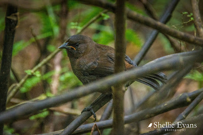
Did you know that the South Island Saddleback/Tieke has a different coloured juvenile to the North Island Tieke? South Island juveniles (commonly referred to as ‘jackbirds’) are covered entirely in chocolate brown plumage for their first year whereas North Island juveniles have the adult black plumage with the beginnings of the coloured saddle.
 |
| Tieke/Saddleback Jackbird- Ulva Island, Rakiura/Stewart Island |
The homestead's lower carpark is also a POP #4565 (park over property), with a maximum of 3 vehicles a night at $20 for two people ($7 extra person). We visited Bushy Park in the ute but thought it would be great to stay & wake up to a dawn chorus although I think our size rig would be borderline getting up the narrow drive & manoeuvring around in the carpark.


.jpg)


.jpg)


