Showing posts with label Beach Hop. Show all posts

Saturday, February 10

Nine Weeks in Napier- Part 2; Two Camps

Catch-up

Continued on from Part 1

To help stave off cabin fever from being parked in suburbia for so long, we headed off on two short breaks away with extended family in their motorhomes. 

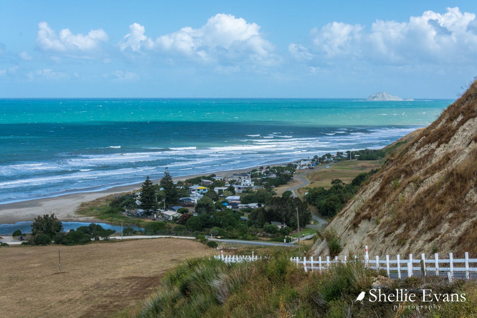
Adding a beach we missed on our 'Beach Hop South'  trip in late 2016, we headed to Ocean Beach just south of Hastings on Boxing Day for a few days. The road down to the beachside settlement is steep and narrow, but, unlike it was when I regularly visited the beach during my teens, it is now sealed.


We set up camp in a large paddock courtesy of a local landowner. The wind was up and the weather forecast not too hot but hey, who needs sunny weather when you can rest, relax, laugh and enjoy the company of like-minded camping buddies who just happen to be family.  My two aunties, Pam & Joy (mum's sisters) and their husbands, Gerald & Kevin, are of similar age to me. Pam & Joy are more like sisters and when time and travel allow, we camp together. One occasion that stands out was a very memorable camp on the banks of the Tukituki River a few years ago.

The old surf lifesaving tower brings back a few memories too; I think I might have even been on that deck a few times in my youth! And not by invite either. 'Nough said.


The weather closed in not long after we arrived, it's hard to believe but there were over 600 people on the beach just the day before- Christmas Day was a cracker in the Bay. 


The cold and gusty southerly kept all but the most hardly away from the holiday hotspot.


Cute wee Meg (belonging to Pam & Gerald) was all kitted out for the wet weather. It was fun to have a energetic bundle of energy camping with us; sometimes I do miss not having a pet.


Though Meg wasn't too pleased to be shut inside our van when she spotted her Dad moving the motorhome. I think she really thought they were leaving without her, she shot out the door like greased lightening when I opened it.


This unusual camper with the pop up luton was staying near us too. A great idea for those that might get a little claustrophobic (and hot) sleeping in the roof space.


On the way home from the beach we stopped for a brief look at the 'infamous' Craggy Range walking track on Te Mata Peak. The track was very popular over the holiday period with dozens of people taking the opportunity of walking it before it is returned to its natural state....even though it was not open to the public and on private land.


Originally I was against the track and not just from the iwi perspective (they really should have been consulted- that was very bad of Hastings District Council). Te Mata Peak is an iconic landmark (also an Outstanding Natural Feature) and a very familiar sight to many people. The 2.4km track is a massive scar on an otherwise natural cliff face. 

Personally I wouldn't like to see trees and plants planted along it's edges as had been suggested- then there'd just be green zigzags up the hill- it would need similar grasses planted to soften the lines. The dry grass and exposed rock face is Te Mata Peak, that's a HB summer right there. Now having seen the track though, I am in two minds. I'm sure it would age in time and not be so noticeable. But would people respect the track? Already the corners were worn where people have cut them off, and then there are those 4WD marks up the side...but, will it be returned to it's natural state? Watch this space.

Click on the photo to see how many people were walking the track.
Our second break (and second visit) was to the DOC Camp at Kuripapango, 70kms up the Napier-Taihape Road at the foot of the 'Gentle Annie' a long and winding, slow haul up and over the Kaweka Ranges. 


We arrived a day earlier than the others and initially set up in the same place as we had done on our previous visit (see link above). But it was not to be. Sometimes things just don't flow as they should and after at least 30 minutes of maneuvering, changing and adding to the blocks to get the van level on the uneven ground, and then finally unhitching and setting up camp, we were invaded by thousands upon thousands of tiny native bees. 

Our new camp site under the kanuka but with not so many bees
The air was black with them, the ground even blacker. It sounded like heavy rain on the van as they pummeled the walls and roof. Not only had we parked across a flight path we had backed over a major hatch. They were emerging out of the ground by their hundreds and milling around in a great swirl near the front of our van. Much to David's disgust, it was time to move.

And the reason there were so many? If you look at the photos above you can see great dusky white swathes of kanuka, flowering across the mountain side and right through camp. Kanuka looks similar but is a totally different plant to the famous Manuka (tea-tree). Kanuka is endemic to New Zealand and doesn't produce the highly sought after Manuka honey.


These native bees are a solitary bee (even though the mass together), they don't have hives but dig nest holes in the ground where they take the pollen for their larvae to feed on. As we found out, a nesting area can be riddled with holes giving the impression of a colony and we had one right under the nose of the van. And yes, they do sting- a tiny needle prick that swells and itches. They don't bother you like honey bees but if caught between a rock and hard place (my foot and a croc and then a crooked elbow) they will sting.

Native bee with pollen on it's legs collecting from Kanuka flowers
The others arrived the next day to find that we'd parked where they usually do too! There were still plenty of bees but nowhere near as many as we'd encountered at the other site. We also had fun watching them dig and disappear into the nearby dirt. In the morning tiny piles of dry dirt indicated where they'd left their nests for the day.


The Kuripapango camp is also known as The Oxbow. An oxbow is where a river forms a loop around a land mass and here at Kuripapango the Ngaruroro River forms the loop around the campsite. Unfortunately the land the camp sits on is about 100 metres above the river and it’s a steep walk down to the river bed. 


It was a typical hot humid Hawkes Bay day when we arrived and after all our fluffing around setting up camp I was keen to head down to the river for a swim to cool off. But boy was the water cold, ice cold, it felt like it was straight off the snow. And no matter how many times I ducked under, it didn't warm up but at least it was refreshing.

David checking for trout
When the family arrived, including two of Pam & Geralds' grandchildren- Zara & Hunter, who often go camping and fishing with them- they also found the water too cold to swim in for long. Instead we headed upstream for a walk and for the kids to practice their fishing skills (legs and ankles covered to ward off the an influx of mossies). We saw plenty of trout but the fishers in the family only managed a couple of small fry that either got off or were released.

Zara finds the perfect seat to wait the trout out
Later Zara made pikelets for us on the BBQ while Hunter acted as waiter, handing them around with cream and raspberry jam. I think they have been watching too many cooking shows- we had to score them! Of course it was 10/10.


The weather Gods were against us once again and the next day dawned cold and misty. 


The weather didn't stop us from heading off to do some exploring. This is us driving through the cloud that had settled over the range. We squashed into the vehicles and set off to the end of nearby Lawrence Road to check out a swing bridge.


We stopped at Blowhard Bush (we've walked the track on a better day) on the way and walked into the Troglodyte Cave (means cave dweller, Kevin) to show the kids, and to look for wetas! 

Then we headed to the end of the road  where a long swingbridge crosses another well known Hawkes Bay river, the Tutaekuri. Those that wanted to, crossed back and forth over the bridge. We had no intention of doing the 3 hour tramp from here to another road end at Puketitiri, although I've added it to my 'must do' list (it's probably about 100km by road). There are also a number of tramping tracks that take you to several huts in the ranges. 


Remember to click on the photos to enlarge and view the slide show.

To be continued...

Thursday, January 19

Beach Hop South- Ngawi- Part 3; The Badlands

Catch-up (Oct 3rd, 2016)

Carrying on from Part 2, the last in the epic Beach Hop Series; travelling from Napier down the east coast through Central and Southern Hawkes Bay and the Wairarapa, visiting most of the beaches along the way. 

The Putangirua Pinnacles are located on the coast road, 22kms before Ngawi in the Putangirua Reserve at the base of the Aorangi Range. We did a day trip back along the road to walk the track to view the Pinnacles. There's a basic and well used DOC campsite beside the Pinnacle carpark. We thought about bringing the van here on our way out of Ngawi but decided we were thoroughly enjoying our lovely camp site near the settlement so why move.


The sign says there are two Pinnacle Walks, either to a lookout high on a ridge above the Pinnacles or up a streambed to the base of the Pinnacles and both are an 1½ hour return walk.


The first few hundred metres of both routes follows the Putangirua streambed along a rough gravel track. The main sign at the beginning of the track is a bit ambiguous, it doesn't tell you like this small sign does, that you can make a loop combining both walks by dropping down from the lookout via a stairway to the streambed below and then walking up to the base of the Pinnacles before returning back along the stream. You wouldn't want to walk it the other way, the climb up the stairs to the lookout is a killer.


We chose to get the hard yards out of the way early and take the lookout route; someone obviously didn't think the directions were very good either, they added a helpful hint to a DOC orange triangle (track marker). White Heather was flowering all along the track and attracting dozens of honey bees.


It's a steady climb to the top of the ridge and then undulating as we follow the ridgeline inland. It's a hot day (unlike our summer presently) and it's a relief when we move out of the open and back into bush. 


This is looking back over Palliser Bay towards the Rimutaka Range & forest, Wellington is just behind that point.


We were surprised when we come across a whole heap of feathers and a few body parts on the track. There'd been an epic fight for life here recently and we're unsure of who was the victim and who was the killer. At first we think the feathers belong to a NZ Falcon/Karearea which upsets us, as we're very fond of falcons. But who could be the killer? A ferret or wild cat perhaps? It would have to be pretty tough to catch and kill a smart predator with sharp talons and an equally sharp bill.


Later, I send photos to my falcon contact- and much to our relief it's not the remains of a falcon-although that's tempered when we hear who the victim is- a Morepork, our native owl. And guess who was likely the killer? Yes, that's right, a NZ Falcon. NZ's only two endemic birds of prey have had a major battle here on the path.

Further on along the track and we have glimpses down into the streambed below and across the gully to a few examples of the 'badlands erosion'  that occurs in this area.


Ahead of us we can see the track ascends another stairway for the upteenth time and to the right it looks like these pinnacles could be the main show.


Shortly before we reach the lookout, a signpost points the way to 'Te Kopi Accommodation'. This is rather strange as it's not mentioned anywhere else and I have visions of people arriving at the top of the track wheeling their suitcases behind, looking at a sheet of paper with their itinerary on it and then looking off down the track for their accommodation. Imagine booking it on the internet and not knowing it's location! 

In fact it's a homestead owned by DOC and rented out to groups and families and it's located on the coast road about 500 metres before the carpark and this is a loop track back to the house. 


We finally reach the lookout platform and there directly in front of us is a spectacular view of the the Putangirua Pinnacles.


The impressive looking pinnacles, also known as 'hoodoos', have been formed over the past 120,000 years by heavy rain which gradually erodes an ancient gravel deposit. The eroded siltstone pillars are a typical example of what has become known as badlands landscape, after the famous American example.


It's hard to get an idea of the size and quantity of the pillars from the lookout so we head down the steep track which joins the lookout walk to the streambed walk (the connection that isn't noted in the information board). There are multiple flights of steps and a very narrow track with steep drop offs, four young guys show us how it's down as they coming bounding UP the track from below. I am suitably impressed and not only by the lithe bodies in running gear.


The track exits onto the wide open gravel bed of the stream (minus a stream)...


...and then it's a steady climb up towards the pinnacles.


There are numerous caverns and gullies to explore although it's a bit spooky as small slides of gravel and the odd rock or two tumble down from above creating loud noises as they bounce of the walls. I stick to the middle and head up towards the pinnacles at the back. 


David takes his time and provides a good size comparison against the pillars, as I take photos (click on the photo to enlarge).


The Putangirua Pinnacles are the third 'badlands' landscape we've visited on our travels, the first were the Cathedral Cliffs at Gore Bay in North Canterbury which were ok, but a little hard to view and only a small example. The second were the Omarama Clay Cliffs in the McKenzie Basin. I loved the Clay Cliffs and would put them at the top of my list, perhaps because I saw them at sunrise as well, but the Pinnacles certainly come a close second.


A slow flowing thick grey slurry weaves it's way down one edge of the pillars- water seepage from high above on the Aorangi Range trickles down between and through the pillars forming deep flutes as the water slowly erodes out the soft garvels and sediment. Heavy rain also erodes the pinnacles and deepens the flutes. 


Where in the world is Wally? David takes a break on a rock to study his tracking app. It's hard to reconcile the lookout view with the view at ground level; which pinnacles were we seeing from above?


In some places the top of the pillars are protected from erosion by a top-knot; a cap of cemented silt or rock, many with tufts of grass or small plants growing on them.


The Pinnacles are a popular attraction for LOTR fans, they were used as a backdrop for the filming of Dimholt Road in the Lord of the Rings, Return of the King. 


Always one to get off the beaten track (and push the boundaries), David explores deep inside one of the side caverns. I wonder to myself how the pillars survive in an earthquake.


Exploring finished, we head back down the gravel slide towards the bottom of the pinnacles...


...where we meet the Putangirua Stream which flows from another small valley down to the sea. 


There are a few more examples of the badlands erosion on the cliffs along both sides of  the valley as we walk back towards the car park, including the ones we'd first seen from the top of the ridge. The track is not that well marked but we follow the compacted shingle tracks formed from the many footsteps that have gone before us, through gorse and broom and back and forward over the stream, rock-hopping to keep our boots dry. 


Back at the carpark we have our lunch sitting on the utes tailgate, overlooking the DOC Campground and the bay beyond. Satisfied 'we knocked the bastard off'.


On the way home we stopped to see who this gravesite, I'd seen in a layby, was for- it's actually a memorial to the 12 crew of the ship Zuleika which was wrecked on the coast here in April, 1897.


With gale force winds forecast, we left Ngawi two days later seeking shelter. We took a quick detour to the mouth of a desolate and windswept Lake Onoke (also known as Lake Ferry) on the way past.


I was a little surprised at the Lake Ferry hotel (established in 1851), I was expecting a grand old two storeyed weatherboard accommodation house with verandas all around and saloon doors. I have no idea why.


We crossed over to the southern side of Lake Wairarapa and headed west along it's shore until we located an awesome POP (park over property) tucked in beside native trees and sheltered from the wind, below the Rimutaka Range.


After a reasonably windy night at Waiorongomai Station we moved onto Featherston, checking out the top end of a very windy Lake Wairarapa (I don't know why I thought we might be able to stay there for a night or two, the wind was horizontal!) Instead, we stayed a night in the free gravel carpark POP behind the Featherston museum buildings waiting for the rain to stop and the wind to drop before crossing over the Rimutaka Range. 

The carpark is for CSC (certified self-contained) vehicles only, but a young foreign couple in a car were also sharing the carpark and looked to have been there for a few days through the awful weather. And while they really shouldn't have been there, David felt sorry for them as we were preparing to leave the next morning; he wanted me to cook bacon & eggs for them, I settled for a bacon & egg buttie each. They were extremely grateful.


We headed over the Rimutakas and pulled into the Kaitoke Regional Park for a couple more nights, letting the wind settle some more before crossing the Strait. 


Our 'Beach Hop' was finished and it was time to head back to the South Island. We had a fantastic time visiting most of the beaches down the east coast, south of Napier and we were very lucky with the weather (surprise, surprise). It had taken us 24 days and we'd travelled a total of 1150kms including our days out exploring. And while the usual 264km route from Napier to Featherston through the Wairarapa is along SH2, we drove the entire distance via the back roads and only drove SH2 once on a 5km detour to visit the Taniwha Daffodils in Waipukurau and touched it again in Masterton when we bought supplies. Pretty impressive tiki-touring, wouldn't you say?!

The rain started again at Kaitoke, and really, it hasn't stopped much since.


Beach Hop South Map- if you'd like to enlarge the map, click on the [ ] in the top right corner.