Wednesday 16 December 2015

Merry Christmas

This is my last post for the year (and for awhile) and I wanted to take the opportunity of wishing you all a very Merry Christmas and a Happy New Year. We leave tomorrow for a few weeks of rest and relaxation out the back of beyond where there is no phone reception which means no internet. It’s time for a break from my computer. It’s hard to believe that during the last two and a bit years we’ve been on the road, I have yet to read a book cover to cover. I’m looking forward to doing something about that.

I knew exactly what photos I was going to use for my Christmas blog as soon as saw the beautiful New Zealand Mistletoe flowering in the Southern Beech trees along the edge of Lake Ohau in the MacKenzie Country.


The name ‘mistletoe’ is given to plants that use specially adapted roots to extract water and nutrients from the stem tissues of their host plant. Unlike some mistletoe species found in other countries, New Zealand mistletoes usually do not harm their hosts. There are eight unique species of mistletoes in New Zealand, the three Beech mistletoes (Green, Red & Scarlet) are now uncommon in many parts of New Zealand.

The colour of the Scarlet Mistletoe is stunning, especially against the beautiful green of the beech trees and the deep blue of the sky. All along the lake edge and high up in the bush were great splashes of brilliant red. The Pohutukawa tree might be known as the New Zealand Christmas tree but the South Island has it’s very own Christmas ‘tree’ which is unique, and just as stunning.


I thought I’d give you a virtual mistletoe to hold above your head- just click on the photo to enlarge, hold your computer (or phone) above your head and hope for a kiss or two from a passing loved one.


Thankyou all for your support and comments over the last year, it’s been a privilege and a pleasure to know that so many of you have enjoyed following along on our travels. Enjoy your Christmas and have a wonderful holiday time with family and friends.

All the very best for 2016 and safe travels wherever you might go.

Best regards
Shellie & David


Tuesday 15 December 2015

Exploring Godley Peaks Road

I’m back to catching up on the new backlog of blogs. I had a brief thought that perhaps I should skip a few or at least condense them a little but then decided against that. The good news is that I shall continue to plod along, there’s just so much interesting stuff to report on, I’d find it hard to pick and choose what to post. The bad news is that this will be the second to last post for a few weeks.

On Thursday, well ahead of the mad frenzy that happens during the pre-Christmas week rush, we’ll be heading off the grid and out of internet and cellphone range. We’ve been looking forward, with much anticipation, to a long break beside one of our favourite high country lakes in Southland. Our Winton family will be bringing their caravan to park beside us for some of the time and we’re really looking forward to spending some quality time with them.

We’ve been parked in the Top 10 Holiday Park at Arthurs Point near Queenstown for the last few days, preparing the van and it's occupants for the Christmas holidays. Lists have been ticked, shopping is finished, the van spic ‘n span, laundry all done, hair cuts completed while the pantry, fridge & freezer will soon be groaning under the weight of four weeks worth of supplies- it’s a long way back to civilization if I forget anything. No doubt the bank balance will also let out a groan.

Which brings me back to this blog post which I must get finished before I do a few last minute chores. We did a day trip from our base in the NZMCA Park at Lake Tekapo, exploring Godley Peaks Road which runs up the western side, to the head of the Lake Tekapo. The road passes below Mt John and the observatory with many places to stop and take in the stunning vistas of the beautiful lake and it’s unbelievable turquoise colour. You can see the road we’re following disappearing over the hill in the distance.


I stitched 4 photos together here for a panorama of the above view, in this one you can see part of another lake, centre left.


That's Lake McGregor and it’s where we’re headed first. We want to check out the camping site before we bring ‘Out There’ up here for a few days. It was no surprise to see lupins growing all along the road verges on our way here and also great clumps growing on the lakes edge. There’s also a fly-fisherman trying his hand just off lake’s edge.


We carry on past Lake McGregor to check on Lake Alexandrina, we’re looking for Australasian Grebes or to be more specific, we're looking for their nests. The lake is only a few hundred metres further on, Lake McGregor is a tiny pool sandwiched between Lake Alexandrina and Lake Tekapo. You may remember we visited here and the top of Lake Aleaxandrina when we were in the MacKenzie country last. It was deserted then and it’s deserted now.


We take a walk along the front of the cribs (aka baches or holiday homes) checking in amongst the boat sheds and around the overhanging trees and grasses looking for a nest.  A lone grebe floats nonchalantly just off shore, we know there’s a nest nearby, one of the crib owners tells us they nest somewhere along the front every year. We don’t locate it and when we next look back another grebe has joined our lone bird and after a brief greeting they both float about like they have no worries.


There are two distinct camping ground areas, one at each lake with another section that stretches along the stream that joins the lakes.


Many of the caravans are closed up for winter, very soon their owners will return for the summer holidays.  We head back to Lake McGregor and stop beside the lake for lunch. We spot a pair of grebes near the roots of a willow tree. It’s very unusual to see them both out of the water. At first we think they might have a nest but they soon swim away and we see that it’s just the tree roots. Perhaps they were checking it out for a possible nest location. Lake McGregor has a mini copy of the famous Lake Wanaka lone tree. We watch as a tourist in a sleeper van washes her dishes in the lake directly below a sign indicating it is an offense to do so. I politely point out that she shouldn’t be doing this.


After lunch we walk back to the stream and decide that this is where we’ll park the van, right beside the lupins with the relaxing sound of a babbling brook below us. Beautiful blooms, trickling water, starry nights, peace and solitude. We can’t wait.


We carry on up the road, heading towards the Godley Peaks Conservation area, that’s Mt Hazard (2123m) in the foreground.


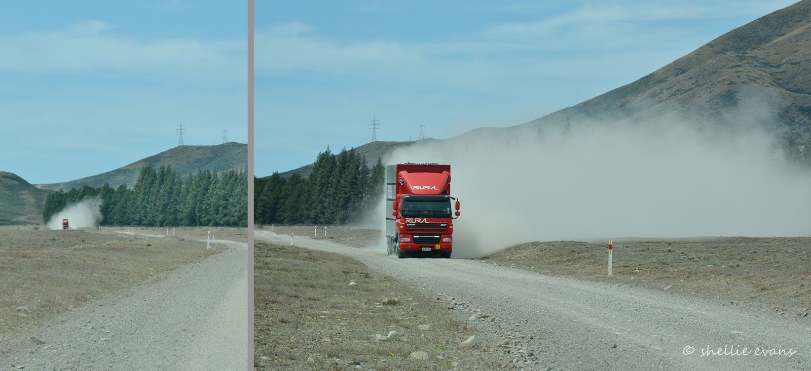
We still can’t escape the dust, an approaching truck swirls a great cloud of dust along behind him, we pull over until he passes.


Once the dusts settles we can see we’re approaching a group of exotic trees lining either side of the road. It’s look like an entrance to a farm station but there are no signs or a cattlestop as is usually the case.


And under the first tree is a flock of merinos with their lambs sheltering from the heat of the day. And to the far left is another tiny lake, Lake Murray. We’re stopping here to explore the lake’s edge, I’ve found out that there is often a pair of Black Stilts feeding in the shallow water. After finding our first black stilt on our Lake Pukaki road trip we’re keen to get a closer view of this very rare and endangered bird.


We park the ute and head off around the edge of the lake. The sheep decide we’re a little too close for comfort and head off in the other direction.


We walk to the top of the lake (it doesn’t take long) scanning the lake through the binoculars as we go.


But all we find is a pied stilt who isn’t too bothered with us but lets all the other waterfowl know that we’re approaching. Ducks and ducklings, swans & signets fast track it out from under the tussock mounds to the centre of the lake. As I walk over a rise, I get a fright as two teddy bears take off for the hills. Ok, well they’re not teddy bears. they’re hares, you’ll have to read this link to see why I call them teddy bears. David tracks them for quite a distance but they out smart us in the end, heading along a dip in the land and up the rocky slope behind the lake.


He spots them sitting on their haunches at the top of the slope, watching us approach along the lake edge before they bound off and out of sight. What magnificent animals they are, we’ve seen quite a few on our travels, mostly in pairs and I’m keen to capture them up close.


With no Black Stilts in sight we continue on around the lake back to the car.


The sheep have settled again nearby and I take a few dozen shots of the cute lambs and their oversized coats.


This little guy especially takes my fancy, he looks a little sorry for himself with his extra baggy coat and wrinkly nose.


We carry on up the road and stop beside the Cass River and the entrance to Godley Peaks Station.


I walk across the bridge, David follows behind in the ute. We stop in the middle and scan the river for trout and the riverbed for terns and stilts. The water is ice blue and crystal clear. The Cass River Delta Conservation area is a release site for captive bred black stilt juveniles, the wide braided lower reaches of the river are ideal stilt habitat.


We drive a few kilometres to the end of the road and turn around in front of the station homestead. Permission is required to travel on further.


We drive back over the bridge and take a side track down to the river to check out the alternate ford crossing. The river is too swift and a little deep so David makes do with washing the wheels in the puddles that have formed in the shingle to the side.


We follow another track down past a long paddock of poplars to a gate, beyond it the track heads across the river’s gravel flats. We’re on the hunt again for Black Stilts. We drive on until we come to swampy ground. We park up and head off towards the river, crossing small streams and boggy ground as we go. We can hear a stilt calling and can see a few birds circling in the distance.


As we get close we can see through the binoculars that it’s definitely a Black Stilt and it’s chasing, first a hawk, and then some gulls, away from it’s territory. It must have a nest or chicks nearby.


Unfortunately it’s too far away for any decent shots and there’s a couple of river braids between us and the river bank it keeps landing on. We settle for a few overhead flybys and watch it carefully as it chases anything that comes close. Sadly it also looks like it’s mate might be a pied stilt too, just like the pair that we saw on the farm dam.


Happy to have found another Black Stilt we head back across the swamp to the ute; it’s time to head for home.


Friday 11 December 2015

Sunrise at the Church

After a busy night shooting the lupins at sunset and then being on a high and not getting to sleep until well after midnight, I decided when I awoke with a start just after 4am, that I might as well get up and going again. Really burn the candle at both ends. I had another shoot on my ‘must do’ list. Lake Tekapo’s Church of the Good Shepherd at sunrise.

But first I took a look outdoors, I do that most mornings early anyway, just in case the most amazing sky is about to appear and I miss it. If it's overcast there's no point in going any further, I might just as well head back to bed (or write another blog), if it’s a clear sparkly sky there's probably no point either. But if there are fluffy patches of clouds, or streaks of the white stuff, then there’s every chance it’s going to be an amazing sunrise (or sunset).

My phone app told me sunrise was at 6:05am so initially I was thinking that as long as I got there by about 5:30am I’d be alright but I’d overlooked how early the ‘blue hour’, a period of twilight before the golden hour of sunrise, begins. Luckily I was ahead of schedule, this photo was taken at 5am.


It is said that the church is the most photographed place in New Zealand and after spending a week in and around the town I can quite believe it is so.


Even at this early hour there were half a dozen photographers lining up to shoot. Although I have to say that I got the jump on them all and was first to arrive. Now why doesn’t that surprise me.


Once the blues and pinks of twilight disappeared the fiery oranges and reds of sunrise lit up the sky.


The clouds reflected the colours beautifully.


Then slowly the colours bled away…(I had to have at least one lupin shot didn’t I)


And the tawny colours of the dry stone and tussocks return to the scene.


Thick grey cloud rolls in from the west and blankets the town. It’s 6:15am when I take this last photo and get ready to leave. Photographers are still arriving to capture the church at ‘sunrise’. They’re way too late for the show.


Thursday 10 December 2015

A Trip Over MacKenzie Pass

Fed up with the wind, and dust blowing around our Tekapo camp, we headed out on another day trip exploring the back country.


Our destination is MacKenzie Pass, a road that we were intending to do the last time we were in the area. But we were side tracked on the day, a very long side track as it turned out. We carried on past the end of the MacKenzie Pass Road and off down a 60km gravel road to Lake Benmore.

I spot an Angler’s Access sign on a farm gate not far before we turn onto the pass road and we decide to check for trout in the river, which is at the end of a farm track. David stalks a large Brown upstream while I take a few photos of the farm bridge and crossing. There’s another vehicle parked near the river and a courtesy notice in his front window telling us he’s fishing upstream which means, if David had been fishing, it is angler's etiquette not to encroach into his fishing space.


We leave the fishing for another day and head back out and onto the MacKenzie Pass Road. As you can see the pass isn’t actually that high, it’s more of a dip in the hills of the Dalgety Range.


It’s hot, dry and dusty and the wind is still blowing a gale. Off in the distance we can see a very large cloud of dust fast approaching; a stock truck comes thundering towards us, a huge dust cloud sweeping along behind it. We move off the road and wait until it’s passed before continuing on and thank God that the wind is blowing the dust away from us.


The James MacKenzie Memorial is located at the bottom of the pass near the MacKenzie River, which is more a dribble than a river, as are many of the waterways in the MacKenzie basin. The memorial marks the spot where James MacKenzie was captured after rustling 1000 sheep.

In 1855 James Mackenzie became one of New Zealand’s most enduring folk heroes. On 4 March he was caught in a pass in the upper Waitaki River basin with 1000 sheep that had gone missing from the Levels station, north of Timaru.
While Mackenzie was in possession of the sheep, the tracks of several other men were visible in the vicinity. MacKenzie denied the theft, claiming that he had been hired by John Mossman to drive the sheep to Otago. After escaping he walked 160 km to Lyttelton, where he was recaptured on 15 March. In April he was found guilty by a Supreme Court jury and sentenced to five years’ hard labour. 
MacKenzie escaped from his road gang in May and again in June 1855, for only a few days each time. Subsequently he was placed in irons and watched carefully. In September a new resident magistrate at Christchurch investigated the case and found flaws in both the police inquiry and the trial. As a result MacKenzie was pardoned in January 1856. He probably returned to Australia, but nothing certain is known of his later life. He left his mark on the South Island high country, though. The significance of the pass where he was found with the sheep, and of the pastoral country it led to, were quickly appreciated by pastoralists. The region was subsequently dubbed the MacKenzie Country.
MacKenzie’s exploits won him the admiration of those on the margins of society. He was a hero to many would-be farmers of small means. Those who resented the power of wealthy landowners also identified with him, and his rebellious spirit inspired many who did not fit easily into genteel Canterbury society. His pardon was popular in a frontier society still engaged in establishing its social and political norms. His life took on legendary proportions. His almost superhuman strength and his ‘fabulous’ dog Friday saw him held up as shepherd, drover and thief extraordinaire- From NZ History
The inscription on the memorial is in English, Gaelic and Maori (Maori in honour of Taiko & Seventeen, the Maori shepherds that tracked the flock to the Pass).


We leave the memorial behind us and start the short climb to the top of the Pass.


We were a little underwhelmed by the view from the top of the Pass, David especially so, he doesn’t even get out of the cab. We leave the crisp dry countryside behind us and head down towards Albury  and into the Waimate District. 


We still have the dust though and we spot a small cloud approaching us from a distance away. A motorbike appears around the corner as we pull over to let him pass. He waves and gives us the fingers……no he doesn’t. He’s indicating that there are two of them. We carry on and the second motorcyclist soon appears, we leave him to eat our dust.


We’re now on the northern side of the pass and driving through rolling green farmland dotted with lily white sheep instead of the dirty grey of the merino sheep of the high country. This family take their time crossing the road as they look for a way back into their paddock.


Albury and the main road are just a short 12kms away but there’s one more stop we want to make before we get there.


We’re going to surprise Dusty, if we catch him at home. The road we're on passes by the front gate of Albury Park Station. Albury Park Station is where we spent a night as guests of Dusty & Kate, parked in their backyard, over a year ago. We’d stayed the previous night on the road side beside the Mt Nessing golf course and as members, had played a game of golf the next day. You can read about those adventures by clicking the links above.

We turned into the drive and headed up to the house passing the historic farm buildings on the way.


Just as we round the last bend, we meet Dusty in his farm ute coming down the drive. He backs up and jumps out to greet us. Friday barks a greeting too (and now I know where her name came from, it’s just clicked- MacKenzie’s dog was called Friday), while a new pup springs and bounds about our feet, giving quick little nips at our heels and hands when we we're not looking. This is 9 month old Stanley (on the left) a new addition to the family and one that seems to have displaced Friday from her perch. Poor Friday, she would have had her nose out of joint when he arrived.

Of course the farm dogs just sit quietly watching the carry on. We had a lovely cup of tea and a catch up with Dusty. We met the station owners as well, they stopped by for afternoon tea with some lovely home baking. The family have farmed the area for over 100 years and their farms reach right back up to the top of the Pass. We left the family talking business and bid Dusty farewell, before continuing on our journey.


Before long we’ve turned back onto the main road and head for home passing through Fairlie before starting the gentle climb through Burkes Pass (a pass that’s not too much of a climb either). We’ve stopped to shoot the iconic church at Burkes Pass before but have not pulled into check out the interesting looking collection of buildings and old cars nearby. Burkes Pass was originally named Three Creeks, and was a wagon stop at the bottom of the pass. The area was first settled in 1859 and is now considered to be the gateway to the MacKenzie Country.

Three Creeks Arts and Craft is built on the site of the former Burkes Pass Hotel which burnt down in 1994. There’s a fascinating and eclectic mix of items from the past for sale along with art and craft from the present including a large range of macrocapa outdoor furniture as well as indoor rimu furniture. An old 38 Morris that used to deliver groceries at the pass sits beside the Coffee Caravan.


The craft shop and coffee cart are popular with tourists and locals alike. Remember the Edmond’s sign, the Four Square Man, well these and a huge number of other signs and symbols of yesteryear, merino wool products, clothing, accessories, decorative household ware, country themed goods, they are all displayed in the various buildings. It’s difficult to know where to look, there’s so much to take in. Photography wasn’t allowed in the main building where all the art, craft and giftware was located but believe me there was an amazing amount of cool stuff in there too.


There’s a treasure trove of recycled and old bric-a-brac in and outside this building. It must take the owners half the day to arrange the goods outside and take it in at the end of the day. I failed to see the mangle on the wooden gate until I was looking through the photos, otherwise I might just have been tempted to add that to our travelling road show.


Old wheels, machinery, it looks like nothing is ever thrown out. The owner was hard at work down the back fashioning more wooden products. What a busy and hard working man.


This very interesting business adds to the life of Burkes Pass and compliments the work that has gone into restoring and retaining this quaint little historic town of the MacKenzie Country. It’s a place well worth a visit when you’re next passing through the area.


And in case you’re wondering; yes I have worked some magic on a few of the photos. I have a new photo processing programme and love what I can do to some of my more rustic and vintage photos. The problem is it takes me twice as long to select the photos for a blog as I end up ‘playing’ with the many different options. I’ve had to be strong and not get distracted, keeping the the new programme for a select few shots only.


Not far from Tekapo (and home) I spot a flock of merino sheep in a paddock beside the road. This is not just another flock of merinos, this is a flock of very expensive merino rams.


Rams with a grizzled, wrinkly and weathered face, and a huge set of curved and clipped horns.


And this photo is fast becoming one of my all time favourites.


And not a lupin in site….