Catch-up; I don't know, I think I'll give up apologising for the lack of blogs and how out of date they are and just do them when I can. Sorry *hehe*
This blog is from the July 2021, right in the middle of winter when we visited the DOC camp at the top of the Ahuriri Valley. Oh what fun!
With a few days of winter sunshine forecast for the middle of July, we decided to head up to the top of the Ahuriri Valley for another visit. The valley is located on the north side of the Lindis Pass, about 20kms from Omarama in the Waitaki District.
 |
| The Ahuriri River & valley- spot the hut? |
We were under
no illusions of how cold it might be, the photo on the back of our rig was
taken there a few years ago when we woke to a -16c hoar frost.
We were more worried about how Birchwood Road would be
after recent snow fall. It’s 24 km of gravel to the camp and the last 4km are not
maintained by the council. The first 20kms are not so smooth to travel either but at least there would be no dust.
The road passes through two farm stations, Longslip Station &
Ben Avon Station. Birchwood Station used to be at the end of the road until it was returned to the Crown and is now part of the Ahuriri Conservation Park. The exclusive 5 star luxury lodge, 'The Lindis', is located on Ben Avon Station, the large steel sculpture at the gated entrance to the lodge makes for a dramatic sight in the expansive landscape as you make your way down the valley. The lodge can't be seen from the road here but if you look over the Ben Avon wetlands on your way back out of the valley you can see the contoured roof of the lodge nestled into a dip in the landscape. It overlooks the Ahuriri River.
Driving the road was an adventure in itself with mud, snow & ice covering much of it's length and progressively getting worse the further into the valley we travelled. There were many ice covered & water filled pot holes. Some we avoided as it was hard to tell how deep they were or if there was thick mud underneath.
Others we smashed through, the cracking ice making a satisfying sound as it was spat out the sides of the rig.
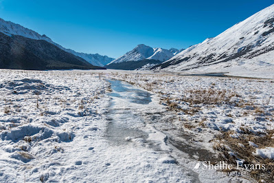
Water flowed off the mountains in random places crossing the road and freezing in amongst the tussock and gravel rock slides creating large ice rinks to cross.
The Ahuriri River; calm & reflective, meanders its way down through the valley. It's a great trout fishery but it's out of season so there'll be no fly-fishing this time.
Finally we made it to the park, opting to open the gate rather than drive through the last large icy puddle over the cattlestop.
We set up camp right beside the river in our usual spot just as the last of the sun disappeared out of the valley, climbing Mt St Mary and turning the air from pleasantly crisp to frigid cold. Time to crank up the diesel heaters as the last of the day visitors heads back to civilization leaving us to enjoy the solitude & stillness of the approaching night.
A photo of the photo taken in nearly in the same spot. We met a 4WD vehicle somewhere in amongst the mud & ice as we travelled in and stopped to let him past. The driver had guests on board from The Lindis and he wound down his window to ask if we knew what we were doing & where we were going (David often answers this question with ' We're looking for a McDonalds'), this time we said 'We sure do, look on the back of the rig as you pull away'.
The crisp winter air makes for crystal clear night skies; here's the Milky Way rising over Mt St Mary. The pink tinge is airglow; luminescence of Earth's upper atmosphere.
The next day dawned bright & sunny so we decided to head further up the valley, test out David's 4WD skills a little more...famous last words.
We pass the old Birchwood Station homestead & cottage on our way, they're located in that clump of trees (back centre) in the photo above.
 |
| Birchwood Station Cottage |
Once through the front yard of the homestead and over the cattle-stop the condition of the road and the accompanying '4WD Access' sign says it all. It's now a 4WD track and ice and snow cover much of it.
We pass the 'Spadeline', if you haven't read the blog link on our first visit which I posted near the beginning, here's the explanation; ....this is the remains of a controversial boundary fence and spade line between the provinces of Canterbury & Otago. The spade line was actually dug out at the time and the indentation is still noticeable in places. The boundary line was drawn using a ruler, it didn’t allow for natural features or the rights of established run holders (and it's still a bug-bear for some people today, I'm regularly contacted by people telling me I've got the wrong province when I mention parts of this area).
We stop at one of my favourite scenes to photograph; the striking green growth on the edges of a stream that snakes its way across the large wetland to the Ahuriri River.
And then it's on to the serious stuff; 10kms of slippin' and slidin' to the end of the track; the water, snow & ice getting deeper & slipperier the closer we get to the head of the valley.
There have been several vehicles along the track already; we pull over & wait for a couple of them to come past.
One couple have decided they can't risk going any further and have turned around and heading back out, another have parked up & the kids are having a snow ball fight. The last kilometre or so is rugged, the track is mostly frozen solid with compacted ice and heads down a long slippery slope towards the river before turning and crossing several water filled rock slides & deep washouts. We're bounced about the cab as we cross over them.
We stop to talk to a couple of hunters who have pulled over to let us past near the Top Dingleburn hut track.
They'd stayed at the hut the night before & had been hunting further up the valley earlier in day, they had found no deer but came across a couple of thar near the river on their way back to their vehicle.
Eventually we made it to the end of the road where we parked up and had a late lunch; a very welcome cup of soup & ham sandwiches!
I thought I might do the 3km walk to Canyon Creek but soon realised that would be impossible, the track was a frozen skating rink with a fast flowing stream tracking along underneath the ice. I tried walking along the edge but the snow covered tussock mounds had me dropping into hidden holes filled with water and ice so I gave that away, promising myself to return and walk the route in the summer.
We head back home trying to remember the course we'd taken at each obstacle or choosing a new direction if it looks better.
Poor David, he was beside himself when we got back & he saw the state of the ute. I mean what did he expect?
When he hadn't come inside after the sun disappeared, I stepped out to see what he was up to. Spare water pump, two flexi buckets of water and he was washing all the mud off! I asked him if he did realise that he still had another 24kms of mud to travel in a day or two.
I should have known better, he has been known to get the water blaster & generator out to clean the ute after crossing over some particularly dusty or muddy roads before.
 |
| Molesworth Station |
We enjoyed another gorgeous winter's day before heading back out of the valley (click on the photo to expand).
While we were having lunch a vehicle arrived and we thought we had neighbours for the night when two guys put up a teepee tent behind us. We commented that hopefully they had plenty of winter woolies with them because the night time temperatures had been dropping to -6 to -8c while we were there. In fact they were doing a photo shoot of the tent for some advertising and were packed up and gone before the sun disappeared. Back to having the place to ourselves!
The next morning (another glorious day) we headed out, back past the icy bogs now not so frozen after a steady stream of visitors to the valley.
Over the frozen rock slides...
...breathing a sign of relief once we reached the Ben Avon Wetlands and the road proper. Just corrugations & potholes to content with for the reat of the journey.
Footnote- we have just spent another fews days up the valley in a totally different season. I'll post that blog next so you can see the comparison.