Friday, July 24

Frozen

Our arrival on a balmy afternoon at Butchers Dam was followed by a frost overnight…


…and an amazing sight to wake up to – well, amazing to this North Islander who has never seen anything bigger than a puddle freeze over. The dam, while not totally frozen, had a large covering of ice over the centre and around some of the edges. I wondered why it hadn’t frozen on our edge as it was very shallow. And while it was a -5 degree frost it didn’t actually feel that cold outside, and yet cold enough to freeze the top of a large body of water.


I waited to watch what the sun rise did to the snow capped Old Man Range, first the sky turned a beautiful mauve hue as the pre-dawn gloom brightened…


…and then as the sun rose higher & crept down the snow, the colour turned a beautiful pink…


…..until finally it reached the bare poplars & willows turning them the rich rustic colours of the golden hour. You can see the iced over sections in the middle of the water.


Across the partly frozen dam the western face of Flat Top Hill stayed in the shade while the willows and bull rushes came alive.


The midday sun failed to melt the ice….


...although it had retreated a little….


....but by 4pm the temperature was dropping again which meant the ice was here to stay.


The next morning there was a glorious sunrise and another surprise in store….


A much heavier frost, minus 7 degrees….


….and the dam frozen right to the edge. Of course there was no way I was walking on it, it was no more than a thin coating but I had fun tapping the edges and watching the ice crack away and spread ripples out under the unbroken ice.


The thick layer of cloud that rolled in just after sunrise stayed put, casting a cold grey pall over the lake.


Flat Top Hill looks very uninviting across the water, luckily we did a walk up there in the sunshine yesterday (a post to come on that shortly).


I took a walk around to the dam wall, passing these rocks which, over the last couple of days, a pair of oyster catchers and a large shag had been jostling for ownership of. I wonder where they have gone to now, especially the shag probably up a nearby stream. It must be lean pickings in the winter.


The movement near the overflow hasn’t frozen, nor a couple of sheltered coves.


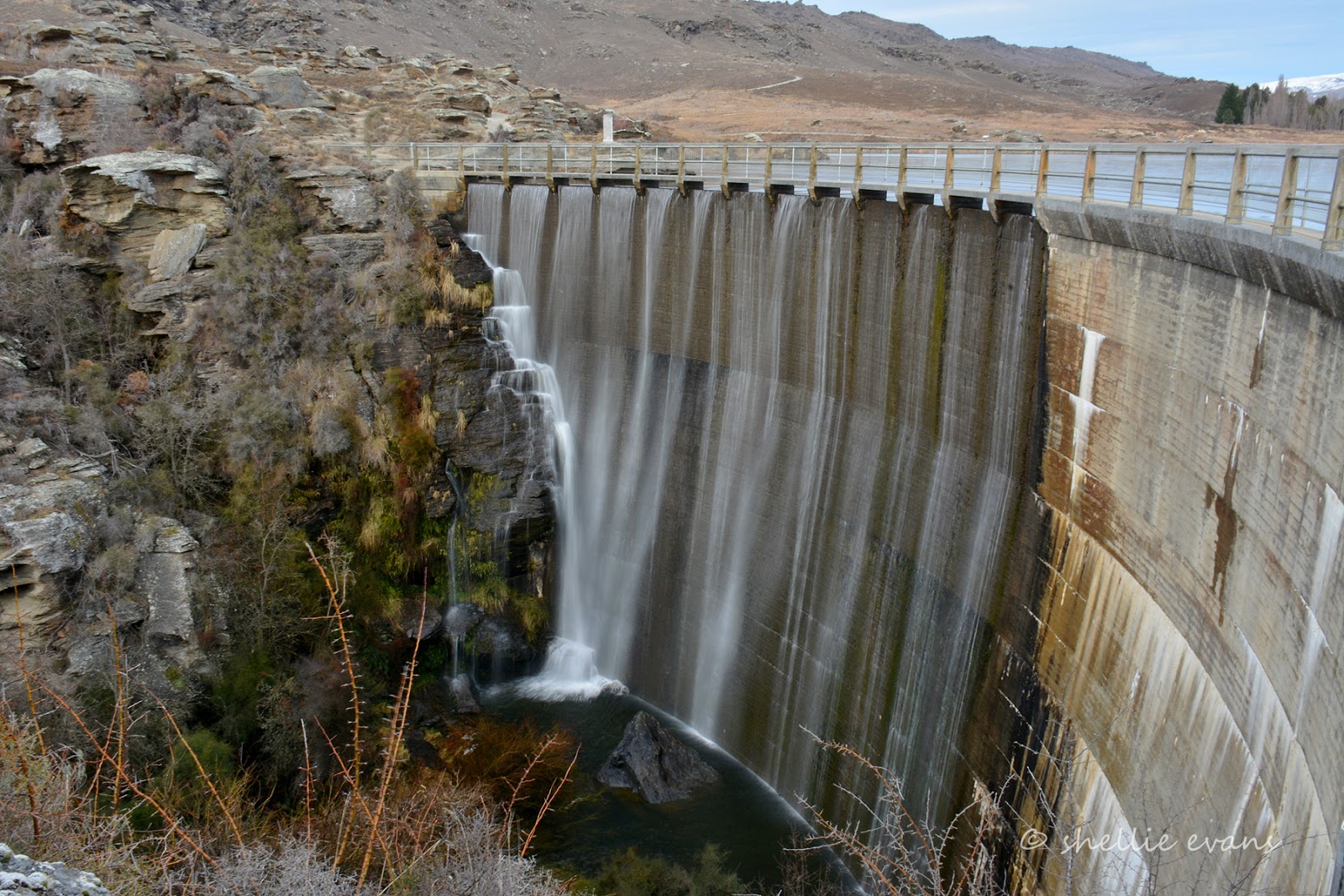
At least the cloud cover allowed me to take a decent shot of the dam wall, the shots the day before had harsh shadows. Just a pity I left my tripod back in the van. Oh well, a steady 'one foot forward, elbows tucked in, don’t breathe’ stance allows me to slow the shutter down (and not fall off the edge!), to make the waterfall silky smooth.


And for those that are interested, the settings for both these were-
ISO100, f/22, 1/4 sec shutter speed.


What a difference,  it’s hard to believe this is the same place we arrived at 36 hours earlier. And I suspect had we arrived when it looked this uninviting we would have carried on and found another place to stay. Which would have been a pity, look what we’d have missed out on. Never judge a book by it’s cover.


Thursday, July 23

Winter Beauty- Butchers Dam

Yesterday morning, after nearly five weeks parked in our Winton family’s driveway, we headed back ‘Out There’. We were sad to be leaving but we know we’ll be back down south in the summer so it won’t be too long before we see them again.

We had an awesome time, lots of laughs, a few surprises and thoroughly enjoyed spending time with Ollie & Ruby especially as the last two weeks were school holidays. It’s great to see that the family have settled into Winton well after shifting from the ‘big smoke’ Invercargill.

I’m afraid we wouldn’t enjoy the winters very much if we had to live that far south though. For at least the first three weeks we had minus 2-5 degree frosts nearly every morning which wouldn’t have been so bad had the day warmed up to something above 5 degrees. At least the sun shone brightly every day. And then the snow came, but that was definitely a highlight. Although it refused to melt for nearly a week which shows you how weak the sun’s warmth was.

I think we’ve jinxed Southland; on the first visit we spent 5 weeks in Invercargill over Christmas & New Year (2013-14) and it blew a howling gale and was freezing cold for all but 3 days and everyone said it was the worst summer they’d seen. This time it’s five weeks in Winton and everyone said it’s the coldest winter they’ve ever had, never mind the dump of snow. Oh, and in between we made a special trip back to attend the Bluff Oyster Festival. Well we know what happened there- we got evacuated when a storm blew the marquee apart. And hail fell on the ground at the campground two inches thick! Hmmm…perhaps we’ll meet the family on neutral territory next time.

We left Winton just as the heavens opened up and it was a wet and gloomy trip all the way through to Gore where we stopped for lunch. Blue sky arrived as we crossed into Otago and by the time we arrived at Butchers Dam it was a relatively warm late afternoon, even with a solid coating of snow along Old Man Range behind us. Butchers Dam is 9kms from Alexandra in Central Otago.


Butchers Dam was built between 1935-37 during the great depression for an irrigation scheme, as were many dams in the Central Otago area. During the 1860s Butchers Gully teemed with gold mining activities and up to 150 people lived in the Gully. Most of the mining took place in the basin that is now the reservoir behind the dam.

A store, butchers shop and hotel were set up in the gully during the 1860s. The hotel was destroyed (by fire) and replaced twice before the last hotel was built in stone in 1890. This hotel was submerged under the reservoir in 1937. It is said that when the water is low the chimney stacks can be seen below the surface.


The remains of a stone cottage belonging to a well know and generous Chinese gentleman, Lye Bow, is located in the poplars across the dam. Initially he mined in the gully during the 1860s, then went on to purchase land and planted the first apricot orchard and market garden in Central Otago.


Butchers Dam is a well known freedom camping area, there are any number of spots to park along the west and north ends of the dam tucked in and around the small coves. It’s a busy place during the summer but all we have for company are the rabbits and a few hardy birds.


It was autumn when we last passed the dam (we didn’t overnight then) and the poplars and willows were stunning in their brilliant autumn colours. One of my photos of the dam then is the cover photo of the NZMCA member’s handbook. But as you can see every season has its beauty.


The owners of the dam allow access across the dam wall to the  Flat Top Hill Conservation Area which has a number of walks around and over it and forms the backdrop to the dam. It also forms part of the Clutha River gorge on the far side.


The dam wall is 24 metres high and 69 metres along the top.The concrete arch varies in thickness from 762mm at the top to 2.7 metres at the bottom. The far half of the dam wall is slightly lower allowing excess water to spill over, falling onto a series of rocks to break up the energy on it’s way down so that the dam base and creek bed are not worn away.


The day’s end at Butchers Dam. Tomorrow we will tackle Flat Top Hill.


Tuesday, July 21

Winton’s Dark Secret

There’s a burial plot in the Winton cemetery that lay unmarked for nearly 115 years, until descendants laid a grave stone in 2009. You might not recognise the names, especially the woman’s name; Willamina McCulloch, although the husband’s surname might ring a bell.


This is the burial place of Minnie Dean, the only woman to have been hanged in New Zealand. There are many myths that surround the case, it is alleged that she murdered illegitimate babies she had in her care at her “baby farm” in nearby Deans Road. She was hung in Invercargill in 1895 and the 12th of August this year marks the 120th anniversary of her death.

Because she was a ‘wicked person’, Minnie Dean was buried 8ft below ground, instead of the usual 6ft. And at the rear of the cemetery in an unmarked plot. For many years the grass above her grave did not grow, which helped fuel stories of Minnie Dean’s wickedness. This was in fact later attributed to a local gardener and his herbicide.


Her husband, Charles Dean died in 1908 and was buried 6ft down in the same grave.


Monday, July 20

Feature Photos

Since we’ve been on the road my photo portfolio has been growing in leaps and bounds- mind you it’s more of an on-line presence than a proper portfolio. I’d love to devote a bit of time to building up an actual portfolio but that ain’t going to happen any time soon so in the mean time, I have to make do with adding my better shots to Flickr, an image hosting website that I belong to.

My Flickr Albums are basically a record of many things and span some eight years of photography. They include many places we’ve visited (not only during the last 20 months of travel either) along with buildings, people, landscapes, animals, birds, and of course, churches I’ve spotted along the way. It’s a private record in a public location. Very public; my account is fast approaching 2 million individual photo views. I do have a few private albums in there too but you won't see them unless you have the link.

It has never been my intention to be a ‘professional’ photographer, I like doing my own thing and I don’t think I’d be that great at it anyway. The few weddings I have done for friends were so stressful it swore me off that genre of photography for good.

I have, however had many requests for various photos from my Flickr Albums over the years and this has been slowly building probably because of the number of photos I’m uploading and the wide variety of places we’re visiting in New Zealand. It also helps that I add ‘tags’ to all my photos when I upload them. I usually upload a batch of photos that are of the area, attach a link to the particular blog post that relates to them (that helps with traffic through my blog) and most importantly, add tags which helps people to search Flickr for particular photos.

For those less computer savy, ‘tags’ are a non-hierarchical keywords or terms assigned to a piece of information. For example in this photo below, I would have added these tags- Department of Conservation, DOC, Hut, Able Tasman, Walk, Great Walk, Anchorage, Bay, Tasman, Accommodation. The more tags and the more relevant they are the more likely that they’ll be picked up by search engines when someone is looking for a specific photo.


Which would have been why I was contacted by the deputy editor of the Wilderness magazine wanting to purchase the above photo for a article in their latest issue.


And here it is- don't worry about what's in the article, this is all about the photo! :)


Within Flickr there are hundreds of thousands of Groups- you'll understand the number when I tell you that there are estimated to be 51 million Flickr members worldwide. Groups are collections of similar photos that can be to do with anything and everything- you name it and there’ll be a group for it. One of the groups I belong to is ‘Heritage New Zealand’ and I link any of my historic or heritage building photos to it. Which is why one of my church photos was requested for a recent brochure.


That’s St Mary's Basilica in Invercargill.


I’ve had many requests for photos for advertising material; where companies don’t need to engage the services of professional photographer for a expansive photo shoot, they may go looking for one-off photos to purchase on the net.

I also get many requests for photos from private people wanting a particular photo so they can have it printed or put on canvas for their wall. Mostly the photo has evoked a memory of a place they’ve left behind or a long ago childhood but one of the more unusual requests has been for this Kereru or native wood pigeon.


It now adorns the splash-back of a new home built in the bush at Titirangi in Auckland.


So, even when not actively seeking out opportunities, it’s pleasing to know that my photos still do have some appeal and it's always a thrill for me to see my photos in print.....or behind glass, whatever the case may be. And I’m earning a little bit of pocket-money along the way.


Thursday, July 16

Walking On A Dream- Part 2

Finally I have caught up-to-date. And it’s just as well as it’s time to hit the road again after our extended stay with the family in Winton.

A few weeks ago the second part of my article was published in the latest NZMCA ’The Motor Caravanner’ Magazine. Not only that but it was a huge surprise to find out that I had also won the Summer Photo Competition with this shot of David on the Key Summit Walk overlooking the Hollyford Valley on the Milford Road in Fiordland. And the prize was a $500 voucher to be spent with a Motor Caravanner advertiser of my choice. Sweet!


Below is the second part of the article, if you’d like to see the first one, you’ll find it here. Although this one has been titled “Taking the Scenic Route’. Remember to click on the page for a larger size if you have trouble reading the article.

Unfortunately this is a copy of a pdf file and the words may be a littler hard to read


Can you see the grasshopper in the photo below? His camouflage is so good that he fooled the layout artist in the page above….


If you'd like to see some more photos (and read more) about each of the places in the article here are the links to their original blog posts-

Kiwi Burn Walk, Snowdon Forest, Mavora Lakes, Southland

Key Summit, Milford Road, Fiordland

Pupu Hydro Walkway, Takaka, Golden Bay

Catlins River Walk, Catlins, Southland

Sawcut Gorge, Marlborough


Majestic Mountains- Lake Hawea

While at Wanaka we did a road trip up SH8, along the edge of Lake Hawea headed towards Haast Pass. Our destination and turn-around point was the DOC camp at Boundary Creek, a few kilometres before Makarora and well before the Pass itself. We’re leaving Haast Pass until we head to the West Coast to do the southern half later this year or it may even be early next.

It was a cold and bitter day- it’s something that has caught us on the hop a little. Yes, we knew it was going to be cold down here, it is after all winter. But some days it's a bone chilling cold that gets under your skin and refuses to budge, even when you’re layered & wrapped up to the hilt. Some days it's hard to get active especially when it's lovely and warm in the van. The diesel heaters have more than earnt their keep. And you’ll notice I said heaters- more than one. We have had the one we left in Christchurch to be repaired returned to us in Wanaka and David re-fitted it with no issues.

The low cloud cover on this day didn’t help either, it always feels more dull and uninviting when there’s low cloud and rain waiting in the wings. We stopped at the Lake Hawea lookout which would have been a fabulous spot to view the mountains across the other side of the lake.....


...had the cloud not been so low.


Looking up the lake I decided that by the time we returned back along the road the cloud might have lifted enough for us to see the mountains and any snow that might be on them. Lake Hawea is huge, it’s narrow and very long, it stretches quite a distance up past the island you can see in this photo.


We follow the road high up above the lake before it passed through a cutting known as ‘The Neck’, a narrow pass that keeps Lakes Hawea & Wanaka apart.


Once through The Neck, Lake Wanaka appears, spread out in front of us with her mountain range in view across the lake.


We now drive along the lake edge at the top end of Lake Wanaka. We stop at the DOC camp at Boundary Creek for lunch but decide to move on when all we can hear are the high-pitched revs of numerous chainsaws. It’s a weekend and there are a number of groups collecting firewood from the lake shore.


We head back towards Lake Hawea, stopping a couple of times to check out roadside waterfalls and the view looking down Lake Wanaka.


We leave Lake Wanaka behind us and pull into The Neck so I can take a photo of Lake Hawea. What a stunning view, you couldn’t mistake this classic New Zealand scene with those cabbage trees in the foreground either. It must be a thrill for visitors to come over the brow of The Neck and have this sight appear in front of them- hopefully with no cloud cover. I can see that our cloud from this morning has lifted.


We drive down below the neck and take a side track that turns in and heads around the otherside of this arm of the lake. We want to check out another DOC Camp, Kidds Bush at Bushy Point. Unfortunately the camp site is closed for winter and the farmer has locked the access gate. So we turn around and pull onto a large open area not far from the gate and close to the lake to have our lunch. Lovely hot soup and a bread roll (or sometimes a sandwich) are our lunch of choice most days at the moment. Enough to warm the cockles and keep the afternoon chill at bay.


The road back along Lake Hawea is across the arm from our picnic site, running along the bottom of this ‘hill’, Isthmus Peak (1417m) which separates Lake Wanaka and Lake Hawea. To get an idea of the height, there’s a house on a plateau, centre right of the photo. What a fabulous view they have.


And here we are travelling that road along the bottom of Isthmus Peak, heading towards the mountain range that was under cloud on our way up this morning.


Looking back across the lake arm towards Bushy Point, somewhere in those tress on the middle left is the DOC camp. We’ll definitely look forward to staying there in the summer.


And what a majestic mountain range it is, it’s very steep, reaching straight up out of the lake.


I think these peaks are part of the Huxley Range, which is further behind and part of the Southern Alps. A private road to Dingle Burn Station runs right along the bottom of the range and around the corner past the island.


The two tallest mountains are Corner Peak (1661m), on the corner of course. And Dingle Peak (1833m) just to the side and behind.


And a final panorama- four photos stitched together- of Lake Hawea (remember to click to enlarge)


We took a drive through the deserted and forlorn looking campground at the bottom of the lake before having a afternoon tea on the foreshore by the holiday settlement of Lake Hawea. I’m sure the settlement and campground are full to overflowing in the summer but today it would seem we were the only ones about.


We drove back home via Hawea Flat where I ‘found’ another lovely country church to shoot, St Ninians Presbyterian Church, built in 1938.