Monday, June 19

The Remote Ahuriri Valley- Part 1

Real-time- it's been a few days since the last blog and I always feel a little guilty about the delay. Some weeks blog posts just flow and other weeks they tend to be start, stop, get distracted, start, stop get distracted affairs. I've just had a one of those weeks!

We left Lowburn heading north up the eastern side of Lake Dunstan and over the Lindis Pass for one last time, we're not sure when we'll be back down this way again, it's time to explore further north. Just before we reached the Summit (where I took this photo), snow flurries began splattering the windscreen. I thought it might have been the start of a heavy fall but sadly it had petered out by the time we pulled up.


At the bottom of the Lindis and 20kms from Omarama we turned hard left into Birchwood Road and headed up the Ahuriri Valley. This 24km gravel road follows the Ahuriri River all the way up the valley into the Ahuriri Conservation Park. From there, there's a 8km 4WD track to the end of the road. The last time I stopped to look down this road, the mountains were covered in snow and it was piled up half a metre deep on either side of tyre tracks through the middle, it was the time of  'the big snow' when I drove up from Winton to check it out.


With the outside temperatures being so chilly now we're into winter (8-10c is a good day), we like to be set up with the diesel heater pumping well before the sun disappears over the mountains. 


About 8kms down the road we decided to pull in and camp on a small level plateau overlooking the river, we'd carry on up the valley in the morning.


I gave David a bit of a ribbing after we'd set up. Of all the places and wide open spaces we could have chosen and we park right beside a bloody power pole! In defence it was the only area where we could look over the river.


We woke to a light frost in the morning and the sun hiding behind the mountain across the river from us. When it did finally reach into the valley we had an amazing view up the braided Ahuriri River valley. This is the river that passes the Omarama Clay Cliffs and runs alongside the DOC camp we stay at near Omarama. The river is also smothered in lupins in spring, although luckily not all the way up here. Yet.


As we headed on up the valley, the cloud had settled along the mountain ridge but there are still a few glimpses of snow along the tops. We pass one of several access points into the conservation park, it's hard to believe that over the range from here is the top arm of Lake Hawea, very near the entrance to Haast Pass, which by road is a very long way away. This part of the track is also part of the Te Araroa Trail, New Zealand's walking trail from the top of the North Island to the bottom of the South Island. We've crossed it on numerous occasions while out exploring.


We know that there are some large high country stations down the road, Ben Avon, Longslip and Birchwood (no longer operating), but are still surprised to see a lovely large new home tucked in under the range, this is a pretty remote area with a hostile winter environment. I later find out that it's a hunting lodge and clients (mainly from overseas) pay thousands of dollars to stay, hunt & fish in the Ahuriri Valley. And to think that we can just drive in, set up camp and do exactly the same should we wish to- though not the hunting bit of course! And I'm not so sure we can arrange the helicopter rides either! 


The Lodge overlooks the beautiful Ben Avon Wetlands, which are just starting to freeze over. Any waterfowl settled on the pond has been forced into a deep corner. They start milling about and stressing out so we leave them to it and carry on along the road.


We finally reach the park boundary where we find a place to park right beside the river. There's not another person in sight and we have the whole valley to ourselves. 


What an absolutely magical place. If only it was the fishing season, once again there are a dozen or so trout swimming through the crystal clear waters right below us. The Ahuriri is an internationally renowned fly-fishing river.


After we'd set up, we headed off to explore further up the valley. The gravel road ends near the old Birchwood Station homestead, stock yards and a 1930s farm cottage. Birchwood was purchased by the Nature Heritage Fund in 2004 to protect the natural landscape and secure public access up the valley, it had been farmed since 1873 and was once described as being more suitable for keas (our cheeky mountain parrot) than sheep.


We're now on the 4WD track although it's not too bad, just some lumpy parts, a few mudholes and a couple of big shingle slides to cross, the rest is slick dry mud. We come across another familiar sight, the 1861 'Spade Line'.  This is the remains of a controversial boundary fence and spade line between the provinces of Canterbury & Otago. The spade line was actually dug out at the time and the indentation is still noticeable in places. The boundary line was drawn using a ruler, it didn’t allow for natural features or the rights of established run holders. We last crossed it when we explored along the edge of Lake Ohau, near Twizel.


We stop to take in this fabulous view across the valley, the emerald green waterway snakes it way across the tussock plain towards bare willows and the river on the far side of the valley. Aside from the stunning green colour which grabs your attention, look at the colour and texture on that mountain too.


Stands of remnant beech forest and large gravel slides line the valley walls. I suggested to David that it would be great fun to toboggan down that trough in the gravel. It's hard to get perspective here but that is a large mountain with very steep sides, those are very tall trees and I'd probably get swallowed up in the gravel coming down at a breakneck speed! It's fun thinking about it though.


We stop to check out DOC's Ahuriri Base Hut, there's a car parked nearby but no sign of occupants. They're probably walking one of the many tramping tracks in the area. 


There are several huts in the mountains above this hut and several more further up the valley. Tramping, mountain biking and horse riding are all encouraged in the park; there's a horse holding yard near the hut. 


Though motorbikes and 4WDriving is not encouraged and there is a barrier across the end of the road. This is as far as we'll be going today.


We turn around and head for home, stopping here and there to check for birds and views.


It takes a few seconds to spot 'Out There' in this vast river plain, we blend in very well against the tussock (click to enlarge)


Zoomed in....


The valley and surrounding mountains turn a stunning colour as night falls and the temperature drops sharply as day turns to night. Both heaters are cranked up, keeping us snug and warm inside; they are certainly going to earn their keep come morning...


To be continued...Part 2

Monday, June 12

Four Camps, Two Walks

Real-time

Originally we planned to stay on in Winton (Southland) for 2-3 weeks but we were having such a lovely time with the family that it ended up being nearly 6 weeks before we pulled out from our cosy corner at the end of the driveway (we heard that the grandkids couldn't get over the size of their yard when they came home from school later in the day). You know you've spent a little too much time in one place when autumn comes and goes. By the time we said our goodbyes, the copper beech had lost all it's leaves.


We decided to ease back into our travels driving a short distance each day as we make our way up the South Island. David's having a few back issues and we need to be in Christchurch towards the end of the month so he can fly to Tauranga to see a specialist. We're hoping it's nothing too serious but want to keep on top of it because, as you can imagine, without a driver we ain't going nowhere fast!

Camp #1 Lumsden NZMCA Park- where nobody loved us, we had the whole park to ourselves on a cold and dreary day that matched our mood. We were missing the family and it always takes a few days to settle back into routine.


Camp #2 On the banks of the Mataura River near Garston. We've visited this hidden gem a number of times to have lunch or to fish but have never stayed overnight. It's a pity it's not the fishing season, and the trout know it too. They kept swimming up and down taunting us.


We had the pleasure of meeting the fifth generation farmer who has his farm on both sides of the river and the main road in the Garston valley. He was shifting a mob of sheep across his vintage 'bailey bridge' with five of his dogs, including Paddy 'the king of the castle'.


As you can see the weather hadn't improved by the next morning as we headed off towards Queenstown. Winter is well and truly underway down south.


Camp #3 Lake Hayes, Queenstown- another familiar reserve, this time we decided to test out the ambiguous freedom camping rules at the lake. On previous stop-overs we've had to park in a small area between the camping signs, but with one sign missing and anecdotal evidence that as long as you are CSC (certified self-contained) you can park anywhere in the reserve at the moment, we gave it a go. 

We found a spot under the willows near the lake's edge. If a ranger came by early in the morning (as had been the case in the past), I didn't see him. And we've yet to receive our recent mail, so if a ticket has been issued the fine may be growing in size as we speak.


Walk #1 Lake Hayes Walkway. For various reasons we had never walked the 7.5km loop walk around the lake even though we've visited the lake several times. I was looking forward to doing it when the autumn colours were at their best back in April, but it was raining when we stopped for lunch before heading to our next destination. 

The track climbs a short distance before winding its way around the side of a large hill that borders the west side of the lake. Ahead of us The Remarkables hide their heads in the low cloud.


And even though the weather still wasn't the best, it was a good time to complete the walk; the lake was a millpond and the reflections magnificent. That's an Australian Coot at the top right, they are usually quite shy but the ones at Lake Hayes are used to people.


We both couldn't get over how many abandoned, disintegrating and rotting dinghies, yachts, canoes, kayaks and sail boards there were, stashed right around the lake's edge. They were hidden under fallen trees, buried in the undergrowth, covered in mould and leaf litter and filled with water. It's such a shame, I'm sure there would be many schools or clubs that would love to have them. I don't understand why the council hasn't done anything about having them removed, many of them are an eyesore.


This dinghy was one of the better ones it also made a good subject, especially with the reflections behind.


Camp #4 Lowburn, Lake Dunstan, Cromwell- I want to say an old favourite but it's not actually a favourite just a very familiar camp site. We seem to stay here on the way to somewhere else or on the way back. This time we had the place to ourselves which is very unusual as it's a huge site and usually very popular. Another 3-4 motorhomes joined us later in the evening but they all stayed up the back. It also happened to be the long Queens Birthday weekend so we stayed a couple of days and expected to see a few more people but they didn't eventuate. They'd probably headed off to warmer climes. 


Finally we had some blue sky and I shot some lovely reflections of boat harbour at the south end of the park.


Walk #2 Bannockburn Sluicings Walk- a 3.5km loop walk we avoid no more! The last time we thought we'd do the walk it was the middle of a hot Central Otago summer. A barren dry landscape on a scorcher of a day does not hold much appeal I can tell you. We read the information board and slotted the walk in the 'must do sometime' folder and headed home for a cool drink in the shade!


The track loops through the former Bannockburn gold field which was sluiced and mined from 1862 into the 1930's. We walked the track anti-clockwise which saved us a bit of a climb in the other direction. Here the sluiced landscape mirrors the natural one of the range in the background.


The track winds its way through the sluicings past the remains of dams, water races, tunnels, stone walls and channels. There are also the remains of a few stone houses including the Blacksmith's shop, and caves and rock shelters where some of the poorest miners lived. 

Menzies Dam (bottom left)  was the largest miner's dam in Otago, the stone walls were at least 2 metres high on three sides of the dam holding water in an area the size of a rugby field. The dam was fed by elaborate stone water races from Long Gully and the Carrick Range up behind us. You'll recall the water race we saw multiple times as we drove the Carricktown 4WD Track and saw the Young Australian Waterwheel.  The dam provided 'liquid gold' for its owners, the water was sold at £4 per week for a 'head' of water, equivalent to 28.3litres (or one foot) per second. Gold sold for £3.15s per ounce in 1872 so it was a considerable out-going expense especially if you had a bad week mining.


The track winds it way through the middle of the sluicings and up onto a small plateau to the remnants of Stewart Town which is behind the dam, and named after one of the dam owners. Here there are the remains of several old stone and rammed earth buildings dating from the 1860s and a very old orchard of apricots & pears that still produce fruit. 


The track then follows the cliff edge back towards the starting point. We've walked right around the outside of this huge chasm. Piles of tailings sit in great mounds along the base of the cliffs. Another walking/mountainbike track  passes straight up the centre of the valley. 

You'll most likely not see it, but if you click on the photo to enlarge, there's a tiny black dot on the path, a person walking uphill. That'll give you an idea of how vast the expanse is. It's also a long way down to the bottom of the cliffs and quite scary to be on the edge- watch children if they're with you on this walk.


Towering cliff faces are all that is left of the hills that have been sluiced away to find the precious gold. Some of the pinnacles we pass were left by miners to mark the corners of their claims and give an indication of how much of the area the miners had sluiced.


Once off the plateau the track passes through this smaller canyon past caves and piles of tailings. Can you see David reading the sign in the top photo below? That also gives you some idea of how much earth has been moved and how the landscape has been changed.


Back in the carpark we can see the bare vineyards of Bannockburn below us, here looking towards the Kawarau Gorge. A new liquid gold. Such is Central Otago.


Thursday, June 8

Bill Richardson Transport World- Awesome!

Real-Time
Whenever anyone hears that we've just visited or about to visit Southland again, the person usually asks if we've visited Bill Richardson's truck museum. The answer has always been no, originally because an appointment had to made to visit, on other visits, we ran out of time and then lately, because we've seen so many different museums on our travels, what was one more? It wasn't a priority.
Bill's Shed
We nearly didn't visit this time either but Rachel kept insisting we would enjoy it. So when our original 2-3 week visit turned into 5-6 weeks, we set aside an afternoon when we knew we were going to be in Invercargill for the day. And I'm so pleased we did. 


This is one amazing transport museum and well worth visiting. Bill Richardson Transport World has one of the world's largest private vehicle collections, holding in excess of 300 trucks and classic cars which are spread over 15,000 square metres, in a purpose built building covering a whole city block.


There are also more than 150 vintage petrol bowsers, along with other motoring memorabilia. 

But first things first, we had a superb lunch in the busy cafe, the very aptly named and themed 'The Grille'. Meals and/or coffee can be had at the usual seating in the main body of the cafe or in either of the 1960/70s 'blast from the past' kitchen or lounge. It's scary when so many of the items are so darn familiar! And so retro now. I loved the TV, it was playing ads from the era.
'The Grille' Cafe
The first part of the building is known as 'Bill's Shed', it's a huge sparkling space with a mezzanine floor and offices around the outside. Sadly Bill died suddenly in 2005 aged just 64. Another shed is named after Bill's only son Harold who was just 29 and a senior figure in the family's trucking company, when he was tragically killed in a car crash in 1995. (Click the photo to read)


Bill's wife Shona & daughter Jocelyn along with her husband Scott now run NZ's largest privately owned transport company, HW Richardson Group. 

Bill's Shed
They have also continued to grow the wonderful legacy Bill left behind; his vintage collection of vehicles has been added to, the new building has been built and it's now open to the public. No more appointments needed to view this amazing collection.

The only working 1940 Dodge RX70 Airflow in the world- a star attraction
These vehicles sit in front of a large city mural from their period and are in a showroom that can be seen from the main road outside, a main road that happens to be State Highway 1 straight into the city. Perfect positioning for tourists on the Southern Scenic Route.


Most of the vehicles have a small sign with their details and many have a note from Bill. I love this personal touch and wanted to read every note. Unfortunately I'd have had to be there all day and more to read every one. 


The note above belongs to this Oldsmobile.


I'm back in the main showroom; Bill's Shed and there are some wonderfully old and colourful trucks...


...and a beautiful collection of pedal cars.


The next shed holds the 'big boys'...


...and a few 'odd boys' too.


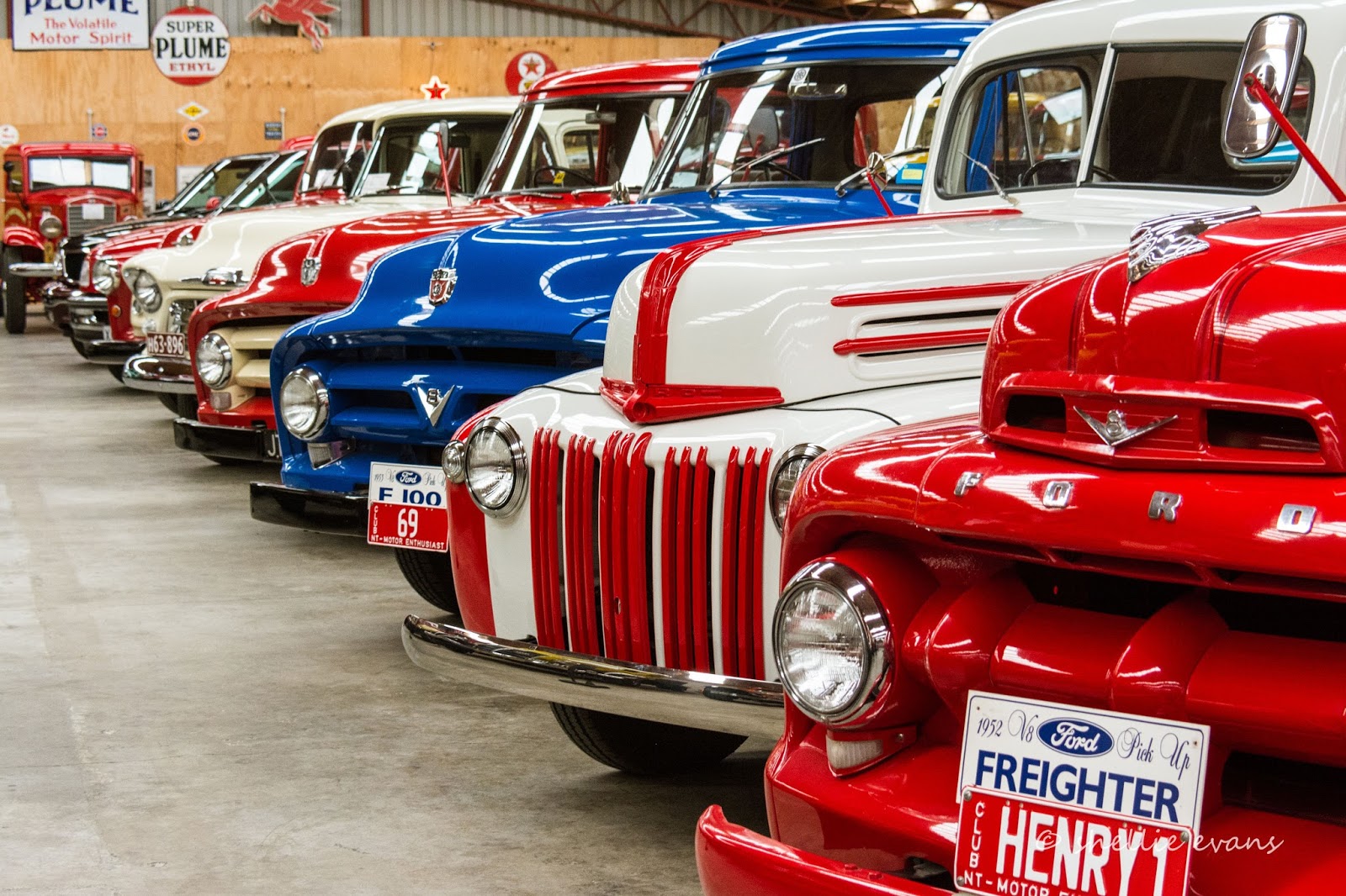
Oh. My. Goodness. This shed holds some real beauties!


Imagine the work involved in polishing this lot. 


We were encouraged to check out the various toilets, both male & female, that were located around the complex. Aren't these just awesome? Although I missed the urinals where men can go about their business while watching people walk past outside through a one way mirror. That's a bit creepy.


Unfortunately, I can't tell you anything about this truck (I forgot to take a photo of the card) but it must be a rarity, it has a prime position.
ETA- In fact I have since found out that it is Mack AC ‘Bulldog’ truck and it was the truck that inspired Mack’s famous Bulldog logo.


Very old trucks...


...and another 'blast from the past', a collection of VW Kombis and their Kombi caravans. I started my working life in a Volkswagen/Audi dealership as a spare parts assistant. 


More vehicles outside storefronts including the model Anglia I wanted Mum to buy for her and me to use when I passed my license. Instead we got an earlier Ford Prefect 100E named Myrtle! Which wasn't quite the cool car I wanted to be seen driving.


There's still quite a few vehicles waiting to be restored and a number stored in sheds not on view. I couldn't get over how many vehicles there were, and how much money would have been involved in restoring and preparing them for display. Along with the ongoing maintenance. 


The curation of such a collection would be massive and I take my hat off to the person/people responsible.  


They have done a magnificent job, everything is well displayed with plenty of information and it' all kept in pristine condition. And there's just so much to see.


In another shed is a collection of tractors and small 'dozers.


And back in Bill's Shed, these very early examples of the motorcar...


Alongside these beauties...


And upstairs, mannequins model wearable art from Southland's previous FibreOctave shows.


Bill Richardson Transport World is a stunning jewel in Southland's Crown and a must visit if you're in Invercargill. But give yourself most of the day if not a couple if you're a petrol head. 

Transport World now has another feather in their cap; Motorcycle Mecca is a new attraction housed elsewhere in the city. In keeping with Invercargill's close ties and obsession with motorcycles it's a collection of over 300 motorcycles that date from 1902 and represent over 60 manufacturers. Tickets can be purchased at Transport World to cover both attractions.


If only he could see it now...


I took so many photos (surprise, surprise), it was hard to choose them for the blog. If you'd like to see more, I've uploaded them to a Flickr Album, click this link to view.