Showing posts with label Wanaka. Show all posts

Sunday, December 22

Winter Scenes from Matukituki Valley- Lake Wanaka

OK, no excuses! Well just a couple; I've been taking way too many photos, and I just don't know where the time has gone. Anyway, here's the next blog which is long on photos, short on words. I'm still posting about Wanaka and it's still winter. 

If I don't make it back here before the big day, can I take this opportunity to thank you all for your continued support over the past year and I would like to wish you and your family a very Happy Christmas surrounded by love, fun and happiness. May all your dreams come true.

The sun sets over Glendhu Bay as one weary fisherman returns home.


Winter colours at a calm and peaceful Parkins Bay.


Heading up the Matukituki Valley into Mt Aspiring National Park.


The mountains tower over a car heading my way out of the valley. Mt Aspiring is hidden behind the clouds on this particular day, I drove the road twice while we stayed at Glendhu Bay Motor Camp.


Sheep feeding on high energy swede beside the Matukituki River.


A population of Black-fronted Terns/Tarapirohe feed on insects disturbed by sheep in the paddocks. These pretty little terns are only found on the braided rivers of the South Island which is where they also breed. 'Black-fronted' refers to the black head cap which reaches down to the bill unlike the bigger White-fronted tern who has a band of white between the black cap and the bill.


I had a good yarn with the local farmer when he stops to see what I am photographing in his paddock. 


He tells me the farm station he manages reaches over the Harris Mountains in front of us, all the way over to the Shotover River near Queenstown. 


Don't you just love the texture on these mountains?


Did you see the waterfalls tracking down the deep crevasses in the photo above? How about the cattle?


I stopped to take photos of the reflections in a small swamp between the road and the river...


...and added a panoramic shot of it too.


I already have photos of this hut in a paddock just before Mt Aspiring Station but I stop to take more.


It was summer when we came through here last. Now I have a some winter shots to add to the collection.


I stopped at the ford which separates the 'good' gravel road from the 'bad' one. The sign tells the story. The road isn't actually that bad, it's the half a dozen fords that you need to cross on the way.


It's here also that the two branches- East & West- of the Matukituki River meet before continuing on down the valley to Lake Wanaka.


There's been a new addition to the roadside along the West Branch since I was here last. 
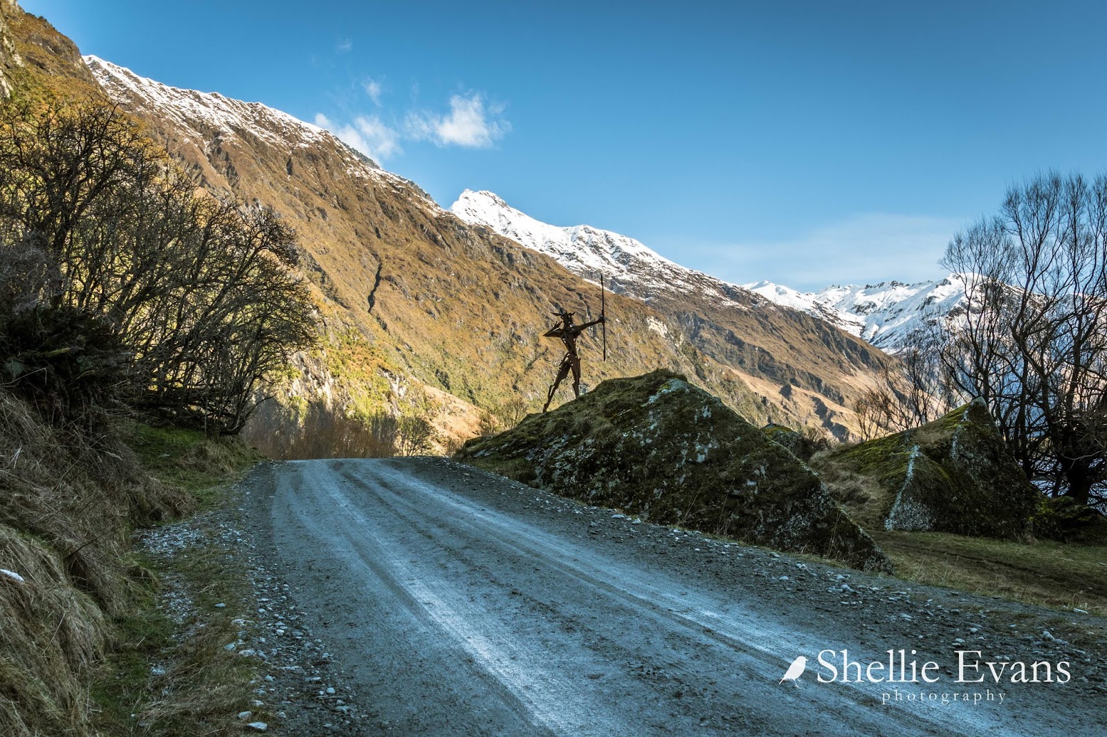

Actaeon Archer (from Greek mythology) is located 34kms up the Matukituki Valley- a very long way from civilization- on a large rock beside the 4WD road to Raspberry Flat & the tracks to Rob Roy Glacier & Mt Aspiring. Simon Max Bannister is the artist and the Actaeon Archer belongs to Mt Aspiring Station who have had it installed here for everyone to enjoy.


The day is drawing to a close and the sun has long gone from this narrow section of the valley. It's very cold and snow lies in the shade in many places.


I make it to Raspberry Creek carpark just as the sun disappears from there too. Raspberry Creek carpark is also the end of the road, from here there are numerous tramping tracks that head up into the mountains and in particular the Rob Roy Glacier Track which is closed at the moment due to recent storm damage and avalanche risk. We walked the Rob Roy Track the last time we visited, the link to that blog is here.


Sharks Tooth Peak towers over the valley...


...and it's not until you look closely that you see another tiny hut at the base of the mountains. This one looks like it has a few added mod-cons too.


I had a late afternoon cuppa in the carpark, sitting in the ute as it was freezing cold outside and even more so when the sun's shadow raced across the valley behind me and swallowed up the last of the sunshine.

I had the whole valley to myself, not another human in sight. But before too long it was time to head for home, I stopped again at the swamp where the reflections were still crystal clear.


With no other traffic about, it was a quick trip home, straight down the middle of the road where it was smooth and slick.


Arriving back at Glendhu Bay just in time to catch the last of the light on a mountain peak across the other side of Lake Wanaka (I think it's Mt Burke).


Sunday, December 1

Magnificent Views from Treble Cone Skifield- Wanaka

Catch-up

While David went fishing, I went exploring. There had been a good dump of snow on the surrounding mountains overnight and with a clear blue sky I decided to visit the Treble Cone skifield which wasn't too far from Glendhu Bay, off the Mt Aspiring road. The skifield is located up near the top of the right 'cone' in the photo below.


On the way I stopped off at a lookout overlooking Lake Wanaka's Emerald Bluffs...


...and Paddock Bay (where David was 'Out There' fishing)


I knew the carparks would be busy; from our campsite at Glendhu Bay Motor Camp we saw a continuous stream of cars, campers and motorhomes making their way to the ski field every morning. And then returning in the late afternoon on their way back to Wanaka. Shuttle buses transferred skiers from the bottom carpark to the top of the mountain although many drove the 7kms to the top.


Holy moly, when I first arrived I thought I'd arrived at a Jucy van rental yard!


I caught the shuttle to the top, with fresh snow it was advised to carry chains and we don't have any. Plus I wanted to take photos out the window as we climbed.

Matukituki River & Valley
There was still room for late morning arrivals at the top. Treble Cone is the largest South Island ski field at 550ha (1359 acres), it also has the longest vertical rise of 700 metres and it's longest run is 4kms. Not that I needed to know all this as I had no intentions of skiing (I gave that up a very long time ago). I'm just happy to take photos and enjoy the view.


The precarious park up of shuttle buses after the morning run. I arrived on one of the last shuttles and there's a two hour wait before the return shuttles start running.


Skiers decked out in the latest gear jostle for the chairlift...


...the beginners slopes are up behind them.


I was hoping to take the 'Six Seater Express' chairlift to the top and back but unfortunately...


...the wind had picked up (blowing snow off the ridges) and it was only open to skiers. 


No worries, this is was what I'd come for! The breathtaking view out over Lake Wanaka and the surrounding mountains. Click on the photo to enlarge. You can see the mountain access road on the right, top and bottom of the tussock covered slopes.


Dead centre is Rocky Mountain & Diamond Lake, there are a few walks over this area which also have some magnificent views. The lake is hidden in the towering rocks on the right handside of the mountain, click this link to see autumn photos of the tiny lake from a previous visit.  The (in)famous Roys Peak is at the back on the right, Glendhu Bay directly below and at the far back you can just see part of Wanaka town. To the left in the valley you can see the Matukituki River and in the middle of Lake Wanaka, Mou Tapu Island.


But for me, the best sight of all was seeing my loved Hawkdun Range, complete with a mantle of snow, at the very back. I had no idea that I'd be able to see the range way over there in Central Otago.


To the left I can also see Mt Alta, the mountain that dominates Lake Wanaka from the southern end of the lake; it's seen from the town and overlooks us at Glendhu Bay.


Here's a zoomed in panoramic shot of the fabulous view- 


And here's one of Glendhu Bay (on the right) and Paddock Bay tucked in front of that hill which is attached to a spit of land. I can even see a spot of white on the water at the entrance to the bay, possibly David fishing in the boat.


I'd brought my lunch with me which was just as well as the queues inside were horrendous. I located myself a table and just as I sat down I spotted a familiar looking bird striding about underneath the tables looking for tasty titbits.


I forgot my lunch for a moment and walked around the back of buildings to where I'd see another bird fly in from. Around the back of the kitchen I found half a dozen Kea (our cheeky endemic mountain parrot) helping themselves to whatever they could find. One was on top of a large plastic container looking into the centre of it. It looked like the container was holding waste cooking oil and while it had a very tiny opening, the Kea was eating the oil flavoured ice from around the bung hole. 


Another three birds were on top of a rubbish truck peering over the side at me, they were only there because someone has chased them away from below the truck where they too were eating food flavoured ice or trying to pull pieces off the rear of the truck.


Up on the bank behind the buildings, only one of the group is doing what Kea should be doing; digging in the snow and pulling out tasty shoots.


By the time I head back to the tables to have lunch, the crowd has thinned out...


 ...and once I've finished eating, I wander up to the carpark above the Base carpark...


...to take a few more before heading back to the shuttle pickup point. I want to catch the first shuttle back down and already a queue is forming. 


I take one last panoramic photo from Treble Cone before I climb into the bus and we rattle off down the mountainside. Some of the drops over the edges are pretty scary as I peer over the side on the hairpin corners. I'm sure some of the drivers we meet coming up the road have a bit of a panic when they meet us coming down at a fairly fast pace.