Showing posts with label festival. Show all posts

Monday, August 9

Back in our Happy Place- Mackenzie Country

 Catch-up

From Poolburn Dam in Central Otago we returned to Mackenzie Country and to our favourite camping spot at Ohau C camp on the shores of Lake Benmore, for some more fishing & relaxation.  

Sunrise, Lake Benmore
And no, that's not David coming home from fishing, he's still sound asleep in bed!

We also had a couple of events to attend and I was looking forward to taking a few more high country sunset photos although I didn't expect to hit the jackpot when the nor-wester made several appearances. 

The Twizel Salmon & Wine Festival is held at the Meridian Rowing Centre on the shores of Lake Ruataniwha on the last Saturday in February each year and because I knew we'd finally be in the area at the right time of the year, we had tickets! 


If you're in the Mackenzie during February mark the date in your diary. It was a great day out with record crowds, fine food, excellent beverages, awesome entertainment and oh so very hot!


Which contrasted terribly with the following weekend in more ways than one. For the first time in it's 28 year history the Goldfields Cavalcade was being held outside Otago. Twizel was the host town & final destination for the more than a dozen horse, walking & mountain bike trails heading in from all corners of Mackenzie Country. 

But sadly the day after the salmon festival (luckily for them), New Zealand went into Covid Level 2 lockdown and disappointedly the public side of the cavalcade was cancelled. Many of the trails were set to leave their starting points so they carried on but without all the fanfare (school & area fundraisers) along the way. In Twizel, Saturday's Grand Parade, market & Hoedown were all cancelled and as if to add insult to injury it rained heavily for much of the weekend as several of the trails finished their rides.


I was hugely disappointed, after attending the Omakau Cavalcade back in 2017 I was looking forward to watching all the different trails arrive & photographing the Grand Parade. I was even more excited as the final camp & holding paddocks were on Glen Lyon Road, just down the road from Night Sky Cottages & some of the trails would be passing the cottages on their way in from Ben Ohau Range.

I did manage to catch Les Beattie's 'Black Hawk Sheep Rustlers' Cavalcade Trail as they rode into a very wet Twizel on Friday afternoon. It was lovely of them to detour past the Twizel Kindergarten to view the children's banners they'd hung on the front fence, welcoming the trails to Twizel. Hopefully Twizel will be able to host the Cavalcade another year.


I photographed quite a few lovely sunrises from the edge of Lake Benmore, right out the back of the fifth-wheeler ...


 And no that's not David either (still tucked up in bed)
On many of the mornings I only had the ducks for company, can you see her? I don't mind them sitting quietly like this, it's when they decide to race each other up and down the edge disturbing my reflections that I get annoyed with them.


I got my own back though when this one waddled out of the water and settled down beside David's drone one day, just as he was about to launch it. I felt a bit mean not letting her know but I've never seen a duck move so fast in all my life! Don't worry, no ducks were harmed & she came right back out of the water demanding food. 


Campers at one of the nearby permanent summer camp sites had fun painting rocks during their holiday break, the red M&M is my favourite.


There were some interesting weather formations; single columns of rain...


White fluffy clouds & reflections...


...and the infamous Nor'wester, which aside from blowing us inside out put on a magnificent display at sundown. You might think that the following shot is from the same evening as the following photos. They're not, this first one is from the night before. 

After watching the cloud formation through the day I thought I'd race up the canals (12kms in the ute) from Lake Benmore to Lake Ruataniwha to catch the sunset closer to where it sets behind Ohau Range and where the sky is more open. I grabbed my gear and struggled, huffing & puffing, up the small hillock behind the NZMCA Ohau B Camp opposite the salmon farm, to wait for more colour. It didn't arrive much to my disappointment.  Although I still managed a couple of half decent shots, and look at all those motorhomers parked down below! 
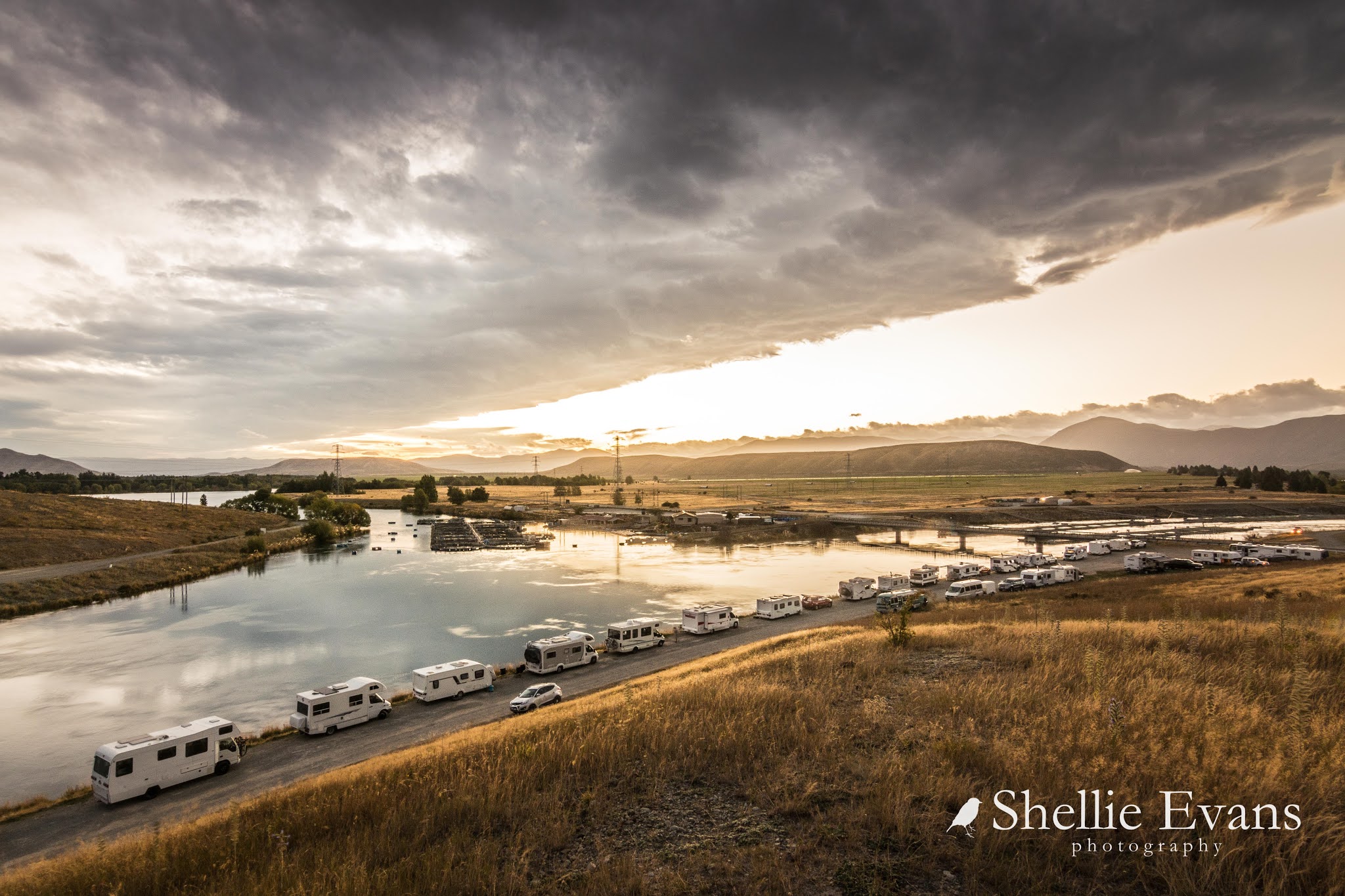

It was a different story the next day though. This time I didn't leave it until the last moment but headed off to Lake Ruataniwha well in advance or so I thought so. Not so. The colour started changing ahead of my expected timing and I had to stop beside the canal to take this one before hurrying on. If there wasn't a touch of cloud covering her, you would be able to see Aoraki/Mt Cook way off there in the background (don't forget to click the photo to enlarge).


I carried on & made it to one of my favourite spots overlooking Lake Ruataniwha just in time to be treated to an amazing display of Mother Nature's brilliance. It's hard to believe that all these photos (and the one at the beginning with the ute in it) were taken of the same sunset, the colours changing by the minute.  

Sunset- Lake Ruataniwha

Ben Ohau & Ben Ohau Range


If you didn't know better you'd swear the sky was pressing down on you. 


And then as the sun drops further behind the mountains, and nearly as quickly as it appeared, the colour bleaches out and twilight takes over. 


If you get the chance to view it, there's another spectacle of Mother Nature that happens during March & into April each year. Sockeye Salmon head up the many rivers & streams in the Mackenzie Basin on their spawning run. The waterways are literally alive with fish; splashing, weaving in and out & fighting as they try to hold themselves over the shallow shingle banks while they spawn. From a distance the river is full of splashes as they move over the shingle, their fins & tails often out of the water.

Sockeye Salmon resting in a cool pool
Sockeye salmon are an introduced species and the Mackenzie Basin is the only place in the Southern Hemisphere where you'll see this happening. Monitoring over the last few years has put the numbers between 40,000 & 70,000. While on their spawning run it is illegal to catch, net or spear the fish, or even walk in the river bed and trample over or disturb their nests (redds).


These are not the Chinook (King) salmon that most people are familiar with and are farmed in the canals. These are quite small in comparison although there have been larger ones recorded. I took these photos from near the highway bridge over the Twizel River. Here's a short video too, most of these fish are waiting in the still water, they move back over the shingle at various stages.

I returned to see them several times over a few weeks; there were hundreds during the first two weeks in March, their numbers slowly dwindling towards the end of March & into April. It was also quite a sad sight after a few weeks. The fish die after spawning and dead & dying fish littered the river bed & floated in the water, many had worn down fins & tails and bleached backs where they'd been exposed to the sun in the shallow water. I thought there would be plenty of birds (gulls & shags) feeding on the dead fish but they were noticeably absent.


On a lighter note, I spotted this very cute cria (baby llama) with his mother in a paddock as I passed by one day. There's quite a herd of llama here but they don't come near the road that often. The wind was blowing a gale this day & this little guy was very unsure of himself, quickly looking for Mum if she stepped out of sight. Look at those gorgeous eyes & eyelashes, oh so cute! 


And to finish with, here's one more from that dramatic sunset! It's nature just wonderful. 


Thursday, September 21

A Visit to Harwoods Hole

Catch-up

Do this lot look like intrepid explorers? Hmmm....thought not. But they do look bright and chirpy don't they. This enthusiast crew of Kaiteriteri Camp locals is about to head off to find Harwoods Hole, the deepest vertical shaft in New Zealand. Well, find isn't quite right either because it has already been found. What we're about to do is the 45 minute walk to see the Hole (6km/90min return).

Back L to R- Craig, Sarah(sitting) Geoff, Brian(not looking!), David
Front- Sheryll & Roseanne
Harwoods Hole is located at the top of the Takaka Hill in the Pikikirunga Range, 11kms inland from the main road along a narrow, corrugated, gravel road. It's part of the Abel Tasman National Park and while it's a long way up behind, as the crow flies, it's not too far from Kaiteriteri.

About half way along the ridge we stop to check out a very interesting area at Canaan Downs where there are several large open clearings surrounded by beautiful mature trees and bush.

The Stage
The eight day long Luminate Festival is held here every two years, an 'earth friendly festival of music, culture, inspiration & transformation' according to the article in that link (check it out for photos). It's hard to believe that over 4000 people converge on this area to set up camp,  party, dance, participate in workshops and get spiritual.


We had a wander around checking out the interesting facilities- I bet the Pizza oven gets a workout during the festival. Some of us tried the outdoor bath out for size, stood in the middle of the standing stone circle and waited for miracles to happen and gave the carvings a kiss or two. We were all impressed with the bank of composting loos; clean, non-smelling and still doing their job six months after the last festival.


I was fascinated with the urine-catcher, a metal strip, a bit like a piece of guttering, strategically placed at the front of the loos; they even mentioned to sit up straight so the stream was directed better! Remember to click on the photo to read more.


Let it all hang free- outdoor showers. I suspect when they're set up they would be inside toilet tents or something similar, there are children on site after all and I'm guessing there'd still be many who would want a bit of privacy. 


And more fancy loos...including a 'Pee Loo Standing'? Isn't that a Urinal? I didn't take a look to check.


You can actually camp at Canaan Downs at any time of the year. As long as you're prepared to drive the road in and the ground isn't covered in snow! We'd happily take the 5th-wheeler in although there'd be a few tight corners and you wouldn't want to meet anyone coming the other way. We thought it would be a great place to hold a rally. That would sort the wheat from the chaff!


We carried on to the end of the road, to the DOC Canaan Downs Campsite and Harwoods Hole trailhead. There are plenty of warning signs at the beginning of the track, along with a two page instruction and information sheet available for cavers thinking of heading down the hole.


We set off a good pace, the track is very easy to begin with, flat and wide with lovely dappled sun shining in...


We passed a couple of small water filled kettle holes where it was hard to see where the water reflections ended and the bush and moss begun.

The track got a little gnarly towards the end with plenty of small boulders and rocks to clamber over and around. Careful attention was needed to avoid the small gaps between them, they could easily trap boots or twist ankles.


Finally we reach a junction in the track, we decide to take the Gorge Creek Viewpoint track first....although it's not a track, it's a route (as it says under the name). Which means it isn't marked and you must find your own way straight up the side of a steep rock covered bank. 


Luckily people have been before us and there's a sort of track to follow although 300 metres still feels like 600 by the time we reach the 'viewpoint'. 'Viewpoint', that's DOC speak for 'it's not a lookout with steps, a platform and barriers'.  No, it's an open space with a bunch of weird looking rocks at the top of a cliff... 


...where, if you manage to clamber over them to the far side, you'll find that you have a magnificent view down to Gorge Creek and across to the the main highway in the Takaka valley over in Golden Bay. 

Those unusual rocks might look nice and smooth and relatively easy to walk over but believe me, they are far from it. These are very sharp edged and uneven karst limestone rock formations with deep and narrow slots separating the sections at irregular intervals. Slip a foot or leg down a gap and you'd be in big trouble. 


With the agility of a goat, Geoff makes it to the far side...


...while some of us were still trying to crawl and slither our way to the edge. Woah! It's scary stuff looking over the edge.


The best way to peer over the edge was to get down on your belly and pull yourself forward.


I decided I'd probably not get back up and knowing my luck (second name Calamity Jane), I'd somehow topple over or worse, drop my camera!


Craig, Sarah and David checking out the view...


 ...and then we had to do all the clambering again in reverse, this time on our hands and backsides downhill. What are you smiling at Craig? You'll be in big trouble now.


Back down at the junction we meet up with Roseanne and Brian who'd carried on to the Hole. They'd been to the lookout before, so didn't put themselves through that little exercise again. We headed off to the Hole, the marble rocks getting bigger and mud getting deeper.


At 183 metres Harwoods Hole is the deepest vertical shaft in New Zealand. A dry sinkhole, the hole drops to an underground river that emerges and flows into Gorge Creek (the valley in the photos from the 'viewpoint'). Henry Harwood (1844-1927) discovered the hole, though it remained untouched until 1958, when cavers were winched down. After a complete exploration in 1959, Harwoods Hole became the deepest explored cave in New Zealand, a record that stood for many years.

Harwoods Hole connects to the Starlight Cave system which eventually exits above Gorge Creek in the side of the hill,  the whole cave system is over 357m in depth. After abseiling down the hole, making their way through the Starlight Cave system, cavers then have to make the strenuous climb back up the hill to the carpark. There have been many rescues and a few deaths over the years,(including a curious walker who got too close to the edge), Harwoods Hole is for experienced cavers only and the complete trip takes a minimum of 9 hours.

A plaque on a rock just before Harwoods Hole- click to enlarge


Finally we reach the end of the track, ahead of us are some very huge jagged boulders and somewhere over the back of them is Harwoods Hole. The entrance is a 50 metre round hole.

We send the advance troops in to find a route....   
"Arr...I think that's the wrong way Sheryll, darling" says Geoff


They regroup and disappear out of sight. I can't go any further with my camera so I leave it on a rock and then slip and slide my way over towards them (phone camera safely installed in my zip-up pocket) 


There's a handkerchief sized piece of flat dirt between boulders near the edge, or what seems to be the edge. You actually can't see down the hole, it disappears underneath the rocky outcrop somewhere. Geoff squeezes through a slot in the rocks to another point further towards the hole but reports that, while he can see the vertical walls opposite, he can't see down it either.  


The rest of us stay on the safe side of the tunnel. I lean on a rock and stretch my arm and phone out as far as I can to take this shot. And that is as much of Harwoods Hole as we're going to see. 


Here are a couple of photos (which obviously, I didn't take) of Harwoods Hole. Looking at the overhead photo, I think we made it to the end of the rocks at the bottom right.