Friday, April 24

The Earth Moved

I interrupt the blog post flow again......

Another first for me on our travels. We're parked up at Lake Brunner, inland from Greymouth on the West Coast.  David's gone fishing and I'm catching up on blogs when all of a sudden 'Out There' starts rocking and rolling. At first I thought someone must be pushing the side of the van but then it got stronger, there was a couple of sharp jolts and the van started swaying sideways. An earthquake! Coming from Hawkes Bay I've felt a few earthquakes in my time and this one was a beauty.

Media reports say it's a 6.3 earthquake centered north west of Kaikoura on the east coast which is just about opposite us. 

It was kinda comforting knowing that I wasn't in a building and that there are no buildings near by, I only had to worry about the ground opening up and swallowing us! I can feel the aftershocks as I type. We'll be in for a rocky night....and I won't be able to blame David as he stumbles to the loo.


Tuesday, April 21

Cover Girl

It was a great thrill and honour to find out, just a few days before the publication of the latest NZMCA magazine, that our rig, our humble abode on wheels, ‘Out There’ has made the front cover. And after the last cover shot, there is no chance of me not recognising this one!

It is also great to see a fifth-wheel RV make the cover of the magazine; I can’t recall seeing our mode of transport & accommodation on the cover before, at least while we’ve been members anyway.

This shot was taken on the Napier-Taihape Road, at the Springvale Historic Suspension Bridge Reserve. It was taken when we were back in the North Island during December & January.


And inside is another contribution from yours truly; Great Walks- a two-part article on some of the wonderful walks we’ve done on our travels- which of course you'll have read before. Still, I’ll post a blog with links to refresh your memories once the magazine has been out for awhile.

Now I must get back to catching up on the back log of blog posts…..


Tomorrow we will leave Greymouth for Lake Brunner and then continue on through Arthurs Pass where we'll not likely have cell phone reception so this might be the last post for a week or so. I'm not sure how long we'll take to get to Christchurch, it'll depend on the weather. 

The West Coast nearly let me down today. Our drinking supply of fresh rain water ran out. Then, just as I was about to head off to buy some, the heavens opened up again. Drinking water containers are full once again along with the house tank.


Monday, April 20

Wash Day

Before heading to the DOC camp at Lake Kaniere, I was hoping to do some laundry in Hokitika. We hadn’t stayed in a commercial campground for while which is where I usually do the washing. Hokitika is just a small town and we found the one and only laundromat just off the main street.

There was a motorhome parked outside and a noisy bunch of girls inside with a ton of gear scattered about, music blaring & all three machines in use. We met the couple from the motorhome at the door, they were just leaving telling us they weren’t going to wait, they couldn't stand the noise.

We walked up town for a coffee & then I returned to the laundromat to see if a machine was free. The girls were still there and all the machines were still running along with the dryers. I asked one of them how long they thought they might be, and whether they needed to hog all three machines!

I didn’t quite catch what she said but another girl piped up and said loudly in a broad Irish accent ‘We’ll be here for the afternoon, we’re washing all our gear. We’ve got bed bugs!”

I said ‘Oh that’s great, you know the machines are cold water wash and that won’t kill them?’

She said, ‘That’s OK, we’ll kill them in the drier, it’s really hot in there’

To which I responded ‘I’m not bloody worried about your gear, what about everyone else who uses the machines?’

Needless to say I decided not to use the laundromat (and I’ll be seriously thinking about not using any public laundromat again after that). I’d rather hand wash our clothes which is what I did once we were set up at Lake Kaniere.

But of course, first you need a good water supply- I don’t like using our precious tank water on doing the laundry if water is in short supply. The initial wash isn’t so bad, it’s the rinsing afterwards that uses too much.


With the water supply sorted, it’s out with the most useful gadget in a RVers arsenal; the obligatory Warehouse flexi-tub. Add the eco friendly laundry liquid and the best tool of all, the plunger and I’m ready to roll. I use hot water from the van- the first hot water wash our clothes have seen in quite some time. The plunger works a treat and actually doesn’t take too much effort to use either. The only problem is the occasional splash back you have to endure when the sucker turns inside out as you agitate the clothes.


Then it’s time for the rinsing, we drive down to the tap and while I fill and rinse the washing a few times David fills the portable water containers to top up the tanks.


Then it’s back to the van to hand-wring the washing (me thinks I need a mangle…but where to attach it?) and then hang it on the drying rack attached to the side of the van. And hope like hell the sun keeps shining. Which it doesn’t. The rain set in that night and it took four days for the clothes to dry. At least we didn’t need to top up the tanks from the tap again. It's all swings & roundabouts in this game.

And all the time I was busy doing the washing I had an audience of locals watching from sidelines- I think they thought I might be stirring up a big pudding for them in the tub.


I love this lifestyle but sometimes, just sometimes, I really miss my Fisher & Paykel.

A sneaky weka making sure he's not missing out.

Sunday, April 19

Dorothy Falls, A Memorial & The Blue Gorge

We stayed three nights in Punakaiki and would have liked to have stayed a few more but the weather was too temperamental and Easter was fast approaching so we decided to head straight through to Lake Kaniere and get a good site at the DOC camp before the Easter onslaught.

We did have an unusual encounter on the Cave Creek walk, I didn't mention it on the last blog though as I thought it wasn't quite appropriate to add it to the end. As we were making our way back up the track, David spotted a small dark animal on the track quite a distance ahead of us. I zoomed in on it and could only see a dark ball of fur.

A wallaby? Don’t be funny, there are none of those on the West Coast.  A wild cat? Highly unlikely out this far, but still a possibility. A big rat? Run for your life Shellie! We crept up on it and as we got closer it turned to the side and I could see that it was a possum, grazing on the track grass. Possums are nocturnal and this was about 4pm so either he forgot to change the clock for day-light saving, or more likely it was sick.

We crept up on it and got quite close before it heard us and ran into the bush on the side of the track. We quickly zeroed in on where it disappeared and David poked about in the undergrowth and under a large flax bush but didn’t find anything. As we were walking away I looked to the tree behind the flax and there it was, down low and staring at me with little beady eyes and gripping the trunk for dear life. He stayed put for quite awhile until David moved closer and he shot off up the trunk to the top at full speed. Where he sat and stared down at us again before crossing over to a larger tree and disappearing. That was our first encounter with a possum in daylight (and it wasn’t going to be too long before the second one either). He was just lucky that we saw him and not someone with a gun.


Our last morning at Punakaiki dawned fine and clear and from our vantage point (zoomed in) I could see that a steady stream of people were already checking out the blowhole.


Not far south of Greymouth is the iconic Taramakau single lane combined rail and road bridge over the Taramakau River. I think this is last remaining rail & road bridge on the West Coast, there used to be one over the Arahura River and a very long one over the Hokitika River. I chuckled at the road sign, there wouldn't be too many places that you'd see a sign like that.


We stopped in Hokitika for provisions and headed out to the DOC camp at Lake Kaniere which is 22kms inland and surrounded on three sides by mountains. We arrived mid afternoon to find that we had the large camp to ourselves. And so it was for the next couple of nights and then as you know, all hell broke loose- here are the blog post links from Easter-

A Quiet & Sunny Easter- Part 1

A Wet & Noisy Easter- Part 2


Easter Sunday dawned fine and with the weather forecast for more heavy rain we decided to do a little exploring while it was clear. We’d also just about had enough of all the power boat noise and needed to get out for awhile. The road continued on and turned to gravel just past the DOC camp, it’s a lovely scenic drive to the top of the lake, through thick native bush with the odd glimpse of the lake and  a few small parking areas beside some of the stream mouths.

About half way along and right beside the road are the Dorothy Falls, a multi-tiered 64 metre waterfall that must look impressive after heavy rain….hmm, it has been heavy rain so either they clear quickly or in fact they’re just a trickle usually. You can just see a tiny tier up the top and behind the front tiers. We decided there must be a few more tiers hidden up there.


And this will give you an idea of the height of the falls, David standing on a boulder at the waterfall pool. I took this from the road bridge.


Across the road from the falls is the Dorothy Creek Walk, a short track leads you out to the lake’s edge and, surprise, surprise, there’s the seat we saw from the boat when we explored up the lake a couple of days ago. What a beautiful spot to sit, relax and take in all the wonderful reflections.


At the top of the lake we pass between two ranges and cross over the Styx River which flows from the Southern Alps and joins the braided Hokitika River system further down stream. I now know that there are Blue Ducks/Whio up this river too- captivity hatched & reared ducklings that were released here once they passed their 'stoat-proof’ weight.


The road now enters the fertile river flats of the Kokatahi Valley where dairy farming is the number one industry. We’re heading towards the Hokitika Gorge- the Blue Gorge, and the road zig-zags across the farmland; left, right, left we turn, the road turns at right angles often. Obviously the farms were in place before the road which has had to follow the farm boundaries.

We stop to view the Kowhitirangi Incident Memorial along the way, a huge rock mounted on a plinth with memorial plagues and cast bronze description plates at the side. This is the site of New Zealand's first mass-murder. In 1941 an unstable farmer, Stanley Graham, shot dead seven men -including four policemen, two home guardsmen and a civilian before he was shot 12 days later and died of his wounds, after one of the biggest manhunts in NZ’s history.


Beside the memorial is this plaque explaining the events as they happened (click to enlarge if you would like to read them & excuse the patch job!)-


This part of the memorial is rather unusual but makes you even more aware of what took place in this peaceful farming countryside a long time ago.


There’s a lot of traffic passing the memorial as we read, and it’s all heading towards the back of the valley on a dead end road. The Hokitika Gorge is one of the top tourist attractions in the district and really is well worth visiting even though it’s 33kms from the Coast road and Hokitika township.

The glacial water (aka glacial milk) that flows through the magnificent granite Hokitika Gorge is a vivid turquoise blue and is caused by rocks, high in the mountains, being ground into a fine powder by the movement of glaciers. The suspension of white powder- known as rock flour- in the blue water creates an intense turquoise colour.

From the car park (it was full so we had to park down the road) there’s a short 2min walk to a viewing platform where you first catch sight of the beautiful colour made more intense and contrasted by the deep green forest that surrounds the gorge.


You’ll have to forgive me, but there are quite a number of gorge photos-

A swingbridge is suspended across the middle of the gorge and there’s a continuous file of people crossing back and forward over it.


On the rocks behind more people are clambering about.


Five minutes further on the track leads onto the swingbridge where only 6 people at any one time are allowed on the bridge. A group of children raced ahead of their parents and past us as we approached the bridge. One was very concerned to count seven after they entered the bridge, he quickly ran back shouting to the others he couldn’t follow because the bridge might break. It was good to see that he was taking note of the signs.

This is looking up stream from the middle of the swaying bridge.


And a further 5 minutes on and we arrive at another platform looking upstream and over a small pool that has formed at the side of the river. The rocks below are covered with people taking photos, there’s a gate in the fence (with a child-proof catch) that allows people down to explore.


There’s also a life-saving ring in case somebody falls in.


Which isn’t surprising when you see some of the places people are posing!


I catch David up at the swing bridge where he’s patiently waiting for me, and watching…


A fisherman on a rock downstream, there’s actually two guys, one is tucked in behind the rock out of view. I’m not sure how they got there but it looks like an awesome spot to be, even if there are no fish.


Back in the car we follow the road further into the hills; it’s a rough track but we’re hoping we might be able to check out the river somewhere along the way before it enters the gorge. After 5-6kms it ends on a gravel patch and it’s a surprise to see so many cars parked up. There are a number of multi-day tramping tracks that leave from locked gate so maybe there are a few people spending their Easter tramping in the mountains.

There’s also an overgrown and boggy walking track that leads down to the river which is quite a distance away, we decide to back up a side track and sit on our tailgate to have lunch while enjoying the birdsong and the distant rumble of the river. Just as we’re leaving another car arrives and a guy gets out and, with a whole heap of gear slung over his shoulder, heads off down a different track through the trees; his gear consists of a shovel, a pick, a gold pan and some other gold finding paraphernalia. Now that was not what we were expecting at all.


Friday, April 17

Cave Creek - Kotihotiho

Punakaiki is a very small settlement that services the 30,000ha Paparoa National Park which has a wide and varied landscape from the lush West Coast native rainforest that we’ve come to know & love, the long and wildly rugged beaches and coastline and the snow covered mountain range that forms the backdrop to this beautiful area.

There are many tramping tracks in the ranges and shorter walks along the coast. One of the most popular tramping tracks, the Inland Pack Track, is a 2-3 days 25km one way walk, unfortunately (though not for us, as we wouldn’t have walked it), it is closed and has been closed since Easter last year when Cyclone Ita blew through. There is a huge amount of windfall and the complete track is not likely to be opened again any time soon although you can walk a shorter middle section. We spoke to a DOC ranger somewhere in our travels and he mentioned that over 20,000ha of forest had been destroyed right along the West Coast.

He also said that people wanting to go tramping, can’t understand why the tracks haven’t been cleared before now- it’s not just a matter of a couple of guys and their chainsaws working their way along a track. There are so many trees down and many of them are huge, it could take a week for them to clear just one tree. Then there’s the root plates to move, the slips that have taken out sections of track and the tracks to repair too. When you see the devastation first hand you can understand why the clean up along the Coast will take many, many years.

The Inland Pack Track passes by the end of the Cave Creek- Kotihotiho Walk. There’s a 6km drive down a gravel track to the beginning of the Cave Creek Walk and, although it does have a name- Bullock Creek Road- I wouldn’t class it as a road. The scenery is once again stunning with towering white cliffs on the otherside of Bullock Creek and a swampy flax covered wetland on the track side. About 3kms along the track there’s a sign advising not to go any further if there’s been heavy rain as the area is prone to flooding. Well it’s been raining for days and the water is just lapping at the edge of the track so we think we’ll be fine driving on.


Eventually the track breaks out into wide open valley where I believe there was a farm a long while ago, the Inland Pack Track crosses here and heads off up the valley. A new gravel parking area has been formed recently near the entrance and there are also new gates that have been added to the beginning of the track- perhaps in time for a 20 year anniversary?


The rain started again and was torrential for about half an hour so we sat in the cab and ate our lunch- which was just as well as when we did open the door the local swam of sandflies invited themselves in. Eventually the sun came out and it was only then that we decided we’d to walk to Cave Creek.


We have walked to Cave Creek before, on our visit to Punakaiki 17 years ago just after the track re-opened, 3 years after a tragic accident- I say ‘accident’ but actually it was a tragic disaster. Most New Zealanders will know and have sad memories of Cave Creek. This beautiful and scenic walk will forever be tarnished because of an incident that happened there 20 years ago this April.


On 28th April 1995, 17 students from an Outdoor Recreation course at the Polytechnic in Greymouth, along with DOC’s Punakaiki Field Manager, crowded onto a viewing platform high above Cave Creek. The platform collapsed and fell about 30 metres into the chasm below. As a result 14 people lost their lives and another four were seriously injured -one became a tetraplegic. Other members of the party arrived at the platform moments after it’s collapse, two raced back up the track and along the road to the main highway to get help (after finding no keys in the vehicles at the carpark), others went to comfort the survivors and bring blankets from the vehicles. Because of the remoteness, it was a full 2 hours before outside help arrived in the form of one police constable from Greymouth. He quickly arranged for helicopters to lift the injured and dead out of the creek bed.

A poignant reminder and memorial of the disaster sits in a clearing not too far from the start of the walk and is adorned with many carefully chosen stones that people have brought with them on their return from the creek bed.


The 2km walk crosses a couple of small ridges before descending into a deep narrow chasm and ending at the Cave Creek resurgence.


The creek bed is full of large boulders and is mostly dry. Beautiful green moss covers the rocks and hangs from the overhanging trees like delicate green lace curtains. The large flat boulders looked like they’ve been tossed about by a giant’s hand and are quite slippery if you put a foot wrong while clambering over them to view the resurgence.


The stream emerges from underneath the rocks in several places but it mainly flows out from inside the dark cave we can see underneath the cliff upstream (left photo below). It is here that the platform landed after crashing down from the cliff 30 metres above. The right hand photo is looking back towards the end of the track which is just to David’s left. It’s not possible to enter the creek bed after heavy rain as the water rises quickly with a raging torrent passing the bottom of the stairway.


We climb back out of the creek bed, the steep wooden stairway turns a few times before we reach the top of the chasm. The area where the platform was located is now fenced off with warning signs about the cliff edge. But it looks like the curious will never take heed, there’s a well worn track around the end of the fence.

It’s a long haul back to the top of the ridge and unbeknownst to either of us we both carry a specially selected stone in our pocket.


I’m glad that the walk is still available, it would have been such a shame to have closed the track for good. Some might think it’s a little morbid but in reality it’s a stunningly beautiful spot and a place where you can take a minute or two to reflect on life and what might have been for fourteen young adults. And while there is no way on earth that they should have died like they did, it must be of some comfort for their loved ones to know that they passed on in such beautiful surroundings.

It is mostly because of this terrible tragedy that we now have so many (some would say too many) DOC signs warning us about the imminent dangers of a particular attraction or walk.
The Cave Creek disaster had a significant impact on New Zealand, 14 people lost their lives in an accident that could have easily been prevented. Although it was a tragedy, the legacy of the students who died and the Conservation Officer still remains and is significant to society today. The Cave Creek disaster was a pivotal point of change for New Zealand. Before this disaster, the Department of Conservation was very blasé about their responsibility to provide safe tracks and structures in parks throughout New Zealand. The Government also overlooked the department when allocated funding before the disaster. This all changed on April 28th 1995. It was only then that these weaknesses were addressed and the country could begin the process of change.- The Cave Creek Platform Disaster


Footnote- just a few weeks ago, I listened to the farming programme on the National Radio, they were interviewing the Stuart family who own Cable Bay Station outside Nelson, the farm that the Cable Bay walking track passes through. Which they instigated and maintain. You might remember we visited Cable Bay but the track was closed for lambing. The family have planted a native bush grove in a small valley near the track and on the coast overlooking Tasman Bay. It is dedicated to their son, Evan Stuart. Who lost his life at Cave Creek.


Thursday, April 16

Punakaiki- Pancakes & Blowholes

Continuing on with our journey down the Coast-

We left Westport just as the rain started to fall and it really hasn’t stopped much since. As the locals say- ‘you can’t have a rainforest without the rain’. But then I’ve also heard them complaining too!

I spotted this poem on a cafe wall which just about sums it up-
Rain
It rained and rained and rained
The average fall was well maintained
And when the tracks were simple bogs
It started raining cats and dogs
After a drought of half an hour
We had a most refreshing shower
And the most curious thing of all
A gentle rain began to fall
Next day but one was fairly dry
Save for one deluge from the sky
Which wetted the party to the skin
And then at last the rain set in
                                                       Anonymous
We’ve cursed it the odd day, but mostly we’ve just got on with it. Because we have no time frame it’s just a matter of sitting out the rainy days (great for catching up on blogs) and venturing out in between showers. One bonus is that we’ve had plenty of rain water to top up our drinking water containers and our house water tanks have been full to overflowing many times.

We made our way down the coast passing through some amazing coastal scenery- the bits we could see between downpours.


I kept reminding myself that we’ll be back this way someday before we bring this journey to an end. But there will be one beach that I’ll return to very soon- a very special beach that not too many people know about. I’m hoping I’ll visit it when we return to Greymouth after we’re finished with Hokitika (which, for those that are directionally challenged is south of Greymouth so we’ll be doubling back to Greymouth for a few days and then crossing over the Divide via Arthurs Pass).

Hokitika will be as far south as we’ll travel the West Coast this time- we'll come up from the bottom of the island to complete it later in the year. We need to get to Christchurch to have some servicing done before the onset of winter…..although I think we missed the memo that says it’s already started! There’s snow on them thar hills.

I’ve passed through Punakaiki twice in my lifetime stopping for a short visit both times, one I can’t remember and the second time was when David and I caught the TransAlpine train across to Greymouth from Christchurch about 17 years ago and then we headed north and over Lewis Pass to Hanmer Springs for a short break. I can hardly remember that visit to Punakaiki either- just a few snippets here and there but one of them was the amount of Nikau Palms that lined the road- Punakaiki didn’t disappoint this time either.


There wasn't too much traffic on the road and when we did pass a vehicle it was mainly hire campervans, so it was a surprise to suddenly round a corner and find a lot of activity in the carparks and on the roadside as we passed the entrance to Punakaiki Rocks.  We’re definitely in tourist country now. We also had our first foreign tourist driver episode (which for my overseas readers has been a major issue in NZ over the summer) where a driver had stopped in the his tracks on a narrow winding section of the road and was backing up. Not pulling over to the left and waiting to do a U turn, just backing up, up a winding hill. Luckily we saw his reverse lights and were able to pull up well in advance. I gave him a polite smile as we passed.....yeah right!

We planned to stop at a CAP (costs apply parking), a NZMCA park over property in Punakaiki for a few nights and we found it just south of the Rocks and right beside the Punakaiki Resort. We were familiar with the resort, we stayed there not long after it opened and when it was known as the Punakaiki Eco Resort, now we were sharing the same beach. The CAP was a great place to stay, a large raised gravel area that had obviously been prepared for subdivision, very close to the blowhole & local walks, and with a wild west coast beach just through the flax bushes. It was just a pity it rained solid for 2 out of the 3 days we stayed, and rained on and off on the 3rd day. But we did get to witness a very impressive thunder storm and light show out over the ocean one night.


Of course our first visit had to be to the famous Pancake Rocks and Blowhole at Dolomite Point, which are located just off the main highway at Punakaiki. The 20 minute loop walk starts out in native rainforest with many Nikau Palms before passing through dense flax and coastal vegetation as it nears the rugged coastline.


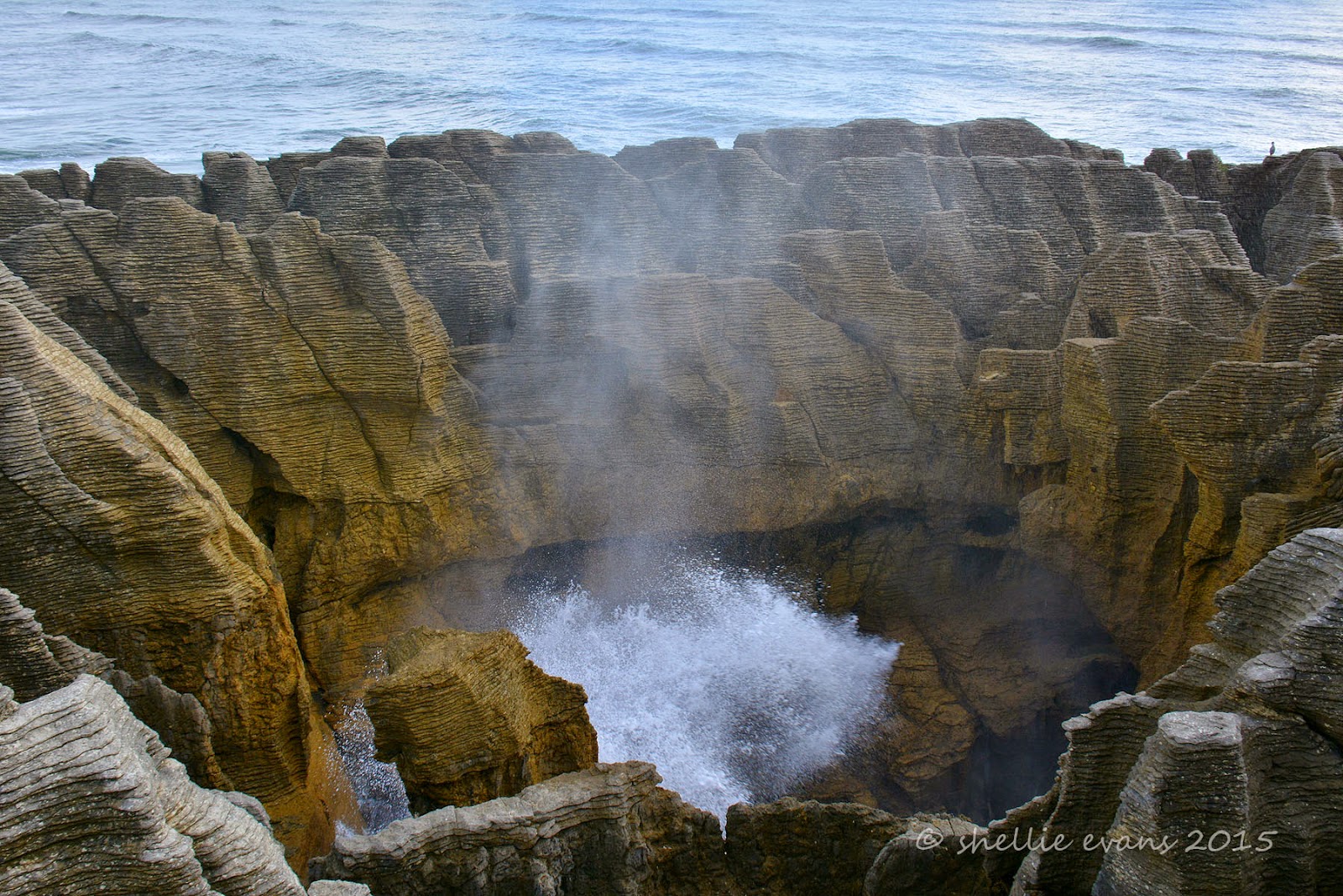
There are numerous formations and smaller blowholes in amongst the rocks before you get to the main iconic blowhole, Putai. This surge pool is called the Devil’s Cauldron and at high tide it lives up to its name as the waves gush in from the sea channel and break against the rock sides getting bigger and higher as the tide rises.


 From the information panel-
Looking like giant pancakes the unusual limestone formations were formed 30 million years ago from minute fragments of dead marine creatures and plants that landed on the seabed about 2 km below the surface. Immense water pressure caused the fragments to solidify in hard and soft layers. Gradually seismic action lifted the limestone above the seabed. Mildly acidic rain, wind and seawater sculpted the bizarre shapes.

The main attraction, is of course, Putai – the largest blowhole – where on stormy days the seawater swells upwards from the rocks in a giant wall of spray. Coinciding high tide with a westerly wind is the best time to visit the blowholes as then the water is forced through underneath the rocks and up into the blowholes producing huge plumes of sea water.

Today, it wasn’t quite high tide and there was no wind but the sea was still a little rough (from the storm overnight), so we managed to see a few reasonable blows.


The Chimney Pot Blowhole-


The walkways, railings, platforms and information panels have been very well done and I’m sure the many hundreds of visitors that walk the track every day, leave feeling they’ve seen an impressive and unique landscape and also learnt a little about how it was formed. Of course a good show by Putai would be the icing on the cake but I don’t think it’s totally necessary to be impressed by this spectacular coastline.

If you look closely, you can see our van parked up near the beach in the background of the photo on the top right. That’s how close we were to the Pancake Rocks.


After the blowholes the track carries on around the edge of the rocks and at one point disappears down through a narrow rocky gap before climbing up the other side….


…to a lookout point, looking north up the coast. It’s late afternoon and the sun makes a brief appearance….along with a rainbow over the top of the rainforest.


There is another well known walking track just up the road from the Pancake Rocks that is also well worth a visit. The Truman Track begins again in a beautiful sub-tropical rainforest of ferns, nikau palms & rimu trees with this coastal tarn (is there such a thing?) right beside the carpark.


As the track nears the coast it passes through dense coastal flax again before emerging onto a headland with stunning views up and down the coast. At this point my memory is jogged; I knew David & I had visited an area before, where we’d climbed down onto a beach underneath a cliff overhang- I thought it was back at the Rocks but that was clearly impossible when I saw how rugged that area was. This was the spot!


A stairway leads down the north side of the headland to a gravel beach with cliffs, caves, a waterfall, more amazing rock formations and what looks like an extinct blowhole. The beach is accessible only at low tide and even then it’s quite scary with the rough seas and crashing waves. I leave David in the cold wind, scanning the ocean for seabirds while I climb down over the boulders and under the tiny waterfalls that are dripping off the rocks above.


I want to take a photo of the waterfall that looks like it’s flowing out of the rock wall at the far end of the beach.


I take a few slow shutter shots to get a silky ribbon of water, but the wind is blowing hard and most of the shots have the water flow at a weird angle.