Showing posts with label cave. Show all posts

Friday, April 17

Cave Creek - Kotihotiho

Punakaiki is a very small settlement that services the 30,000ha Paparoa National Park which has a wide and varied landscape from the lush West Coast native rainforest that we’ve come to know & love, the long and wildly rugged beaches and coastline and the snow covered mountain range that forms the backdrop to this beautiful area.

There are many tramping tracks in the ranges and shorter walks along the coast. One of the most popular tramping tracks, the Inland Pack Track, is a 2-3 days 25km one way walk, unfortunately (though not for us, as we wouldn’t have walked it), it is closed and has been closed since Easter last year when Cyclone Ita blew through. There is a huge amount of windfall and the complete track is not likely to be opened again any time soon although you can walk a shorter middle section. We spoke to a DOC ranger somewhere in our travels and he mentioned that over 20,000ha of forest had been destroyed right along the West Coast.

He also said that people wanting to go tramping, can’t understand why the tracks haven’t been cleared before now- it’s not just a matter of a couple of guys and their chainsaws working their way along a track. There are so many trees down and many of them are huge, it could take a week for them to clear just one tree. Then there’s the root plates to move, the slips that have taken out sections of track and the tracks to repair too. When you see the devastation first hand you can understand why the clean up along the Coast will take many, many years.

The Inland Pack Track passes by the end of the Cave Creek- Kotihotiho Walk. There’s a 6km drive down a gravel track to the beginning of the Cave Creek Walk and, although it does have a name- Bullock Creek Road- I wouldn’t class it as a road. The scenery is once again stunning with towering white cliffs on the otherside of Bullock Creek and a swampy flax covered wetland on the track side. About 3kms along the track there’s a sign advising not to go any further if there’s been heavy rain as the area is prone to flooding. Well it’s been raining for days and the water is just lapping at the edge of the track so we think we’ll be fine driving on.


Eventually the track breaks out into wide open valley where I believe there was a farm a long while ago, the Inland Pack Track crosses here and heads off up the valley. A new gravel parking area has been formed recently near the entrance and there are also new gates that have been added to the beginning of the track- perhaps in time for a 20 year anniversary?


The rain started again and was torrential for about half an hour so we sat in the cab and ate our lunch- which was just as well as when we did open the door the local swam of sandflies invited themselves in. Eventually the sun came out and it was only then that we decided we’d to walk to Cave Creek.


We have walked to Cave Creek before, on our visit to Punakaiki 17 years ago just after the track re-opened, 3 years after a tragic accident- I say ‘accident’ but actually it was a tragic disaster. Most New Zealanders will know and have sad memories of Cave Creek. This beautiful and scenic walk will forever be tarnished because of an incident that happened there 20 years ago this April.


On 28th April 1995, 17 students from an Outdoor Recreation course at the Polytechnic in Greymouth, along with DOC’s Punakaiki Field Manager, crowded onto a viewing platform high above Cave Creek. The platform collapsed and fell about 30 metres into the chasm below. As a result 14 people lost their lives and another four were seriously injured -one became a tetraplegic. Other members of the party arrived at the platform moments after it’s collapse, two raced back up the track and along the road to the main highway to get help (after finding no keys in the vehicles at the carpark), others went to comfort the survivors and bring blankets from the vehicles. Because of the remoteness, it was a full 2 hours before outside help arrived in the form of one police constable from Greymouth. He quickly arranged for helicopters to lift the injured and dead out of the creek bed.

A poignant reminder and memorial of the disaster sits in a clearing not too far from the start of the walk and is adorned with many carefully chosen stones that people have brought with them on their return from the creek bed.


The 2km walk crosses a couple of small ridges before descending into a deep narrow chasm and ending at the Cave Creek resurgence.


The creek bed is full of large boulders and is mostly dry. Beautiful green moss covers the rocks and hangs from the overhanging trees like delicate green lace curtains. The large flat boulders looked like they’ve been tossed about by a giant’s hand and are quite slippery if you put a foot wrong while clambering over them to view the resurgence.


The stream emerges from underneath the rocks in several places but it mainly flows out from inside the dark cave we can see underneath the cliff upstream (left photo below). It is here that the platform landed after crashing down from the cliff 30 metres above. The right hand photo is looking back towards the end of the track which is just to David’s left. It’s not possible to enter the creek bed after heavy rain as the water rises quickly with a raging torrent passing the bottom of the stairway.


We climb back out of the creek bed, the steep wooden stairway turns a few times before we reach the top of the chasm. The area where the platform was located is now fenced off with warning signs about the cliff edge. But it looks like the curious will never take heed, there’s a well worn track around the end of the fence.

It’s a long haul back to the top of the ridge and unbeknownst to either of us we both carry a specially selected stone in our pocket.


I’m glad that the walk is still available, it would have been such a shame to have closed the track for good. Some might think it’s a little morbid but in reality it’s a stunningly beautiful spot and a place where you can take a minute or two to reflect on life and what might have been for fourteen young adults. And while there is no way on earth that they should have died like they did, it must be of some comfort for their loved ones to know that they passed on in such beautiful surroundings.

It is mostly because of this terrible tragedy that we now have so many (some would say too many) DOC signs warning us about the imminent dangers of a particular attraction or walk.
The Cave Creek disaster had a significant impact on New Zealand, 14 people lost their lives in an accident that could have easily been prevented. Although it was a tragedy, the legacy of the students who died and the Conservation Officer still remains and is significant to society today. The Cave Creek disaster was a pivotal point of change for New Zealand. Before this disaster, the Department of Conservation was very blasé about their responsibility to provide safe tracks and structures in parks throughout New Zealand. The Government also overlooked the department when allocated funding before the disaster. This all changed on April 28th 1995. It was only then that these weaknesses were addressed and the country could begin the process of change.- The Cave Creek Platform Disaster


Footnote- just a few weeks ago, I listened to the farming programme on the National Radio, they were interviewing the Stuart family who own Cable Bay Station outside Nelson, the farm that the Cable Bay walking track passes through. Which they instigated and maintain. You might remember we visited Cable Bay but the track was closed for lambing. The family have planted a native bush grove in a small valley near the track and on the coast overlooking Tasman Bay. It is dedicated to their son, Evan Stuart. Who lost his life at Cave Creek.


Sunday, April 12

Moria Gate Arch- Oparara Basin

The 30 minute walk to the second arch in the Oparara Basin is through some stunning scenery, the rainforest is an enchanted wonderland; a large variety of mosses in all shades of green cling to and drape off every available trunk, branch & twig. Soft green ferns cover the forest floor and taller tree ferns spread their feathery fronds overhead. There’s also alot of birdsong and the odd alarm call, as flashes of movement catch our eye as birds fly from tree to tree.


A lot of foresight, money, hard work & volunteer hours has gone into making the Oparara Basin the jewel in the crown of the northern West Coast’s ecotourism attractions. It’s a pity that the road can’t take bigger tour buses & motorhomes as many people miss out on seeing this spectacular area (actually, that in fact might just be a good thing after seeing the over-run carparks surrounding Punakaiki Rocks later on in our trip).


More enchanted forest and a natural moss topiary.


The track eventually led to this rocky hole in the ground. We were thinking this can’t be the Moria Gate Arch surely? Then David spotted a chain rope down the side of the rocks and after clambering through we inched our way down over the boulders into darkness.....


…to be greeted by this amazing sight- the Moria Gate Arch! The arch was named in 1984 after the mythical gate to the dark world in the Lord of the Rings trilogy.


And just to show you the shear size of the cavern, there’s David standing on the rocks to the side, looking for blue ducks again.


The Moria Gate Arch is viewed in 3D, there's the arch above- looking into the cave- then the one below looking down stream from inside, the rocks in front are about where David is standing in the photo above.


And the third one, looking back in the other direction, up-stream.


And up-stream again, with David silhouetted to put things in perspective.


Moria Gate Arch is spectacular and by far the loveliest of the two arches, a visual treat and an amazing feat by Mother Nature. Absolutely stunning.


We clamber back out through the opening in the rock meeting another couple finding their way inside. If you ever visit Moria Gate, don’t be put off by this odd entrance, it’s quite safe with the chain to help you up and down but sturdy shoes are a must to help with grip on the slippery rock surfaces.


The Moria Gate Arch Track forms a loop crossing over the Oparara River and passing the Mirror Tarn on it’s way back to the carpark. I decide to walk the loop- it’s another hour back to the carpark, David retraces his steps and will then drive to the Tarn carpark and meet me there. It is a shame as just a little further on the forest becomes even more beautiful- if that is possible- I could explore out here for hours, studying every little plant, moss and insect I came across. There are so many beautifully formed miniature mosses & lichen. I’m not sure the short bit of track with the moa print paving stones over the top of the arch is quite the look but I guess it’s providing protection.


It’s actually a surprise when I come to a short side track that leads to a lookout with a view back towards Moria Gate Arch. At this stage I hadn’t realised that those moa print pavers actually led me over the top of the arch. You couldn’t see down either side, it was just a track through thick bush. Clever idea and it does protect the arch.


The arch was stunningly beautiful from this angle too, and that tannin stained Oparara River just adds to the beauty and mystique of the place.


As I said the track just gets prettier and prettier, this has to have been one of the most beautiful walks I’ve done. I just wish David had done it with me.


I caught sight of movement a few steps ahead of me and found this beetle scurrying across the path. This is a native Stinking Ground Beetle, the Maori name Kurikuri means dog-like. It can give a sharp nip- one look at those pincers tell me that- and also emit a powerful stench if disturbed. I was unaware of that defense. I carefully transferred it to the end of this stick, took some photos and then poked the stick in a log, which the beetle quickly disappeared into. He must have been happy with me, no stench detected!


I stopped once again at the Mirror Tarn, the sun had come out a little since my earlier visit and the reflections were not so sharp. I found a henna painted WWOOFer with a weird hairdo contemplating life beside the tarn and taking up most of the tiny viewing space. He told me he’d brought a car load of backpackers up to the Basin for the day and they were off walking. He just wanted to soak up the beauty and I got the impression I was disturbing his peace with my clicking! Smile


I left him to his solitude and headed back down the track which was running along side the Oparara River again. I met David about halfway, he’d brought the car up and was walking in to meet me.


We had an awesome day exploring the Oparara Basin, seeing amazing limestone arches, unusual caves and the most beautiful scenery- my highlight was the Mirror Tarn followed a close second by Moria Gate. I’d highly recommend a visit to this very special place if you are in the area. If you’re in a motorhome though, I’d beg, borrow or steal a car so you can get there safely. Or arrange a tour from Karamea.

I have a little story to share before I leave the Basin-
I very nearly lost my phone to the Oparara Basin- now that would have been a disaster & you’d most probably still be waiting for blog posts. I’d be lost without my phone’s ‘hotspot’ (yes, I could have used David’s, but he’s rather protective of his data).

You’ll remember I very nearly killed my phone when we walked the Sawcut Gorge, forgetting that I had it in my back pocket as we waded through a deep pool. After some tender loving care and much swearing and frustration David managed to nurse it back to health. Phew many $$$$ saved.

So it was with great alarm and an awful sinking feeling when I heard a ‘kurplunk’ as I rearranged my clothing after visiting the loo before we left the carpark for home. ‘Oh no, bloody hell’ I thought (or words to that effect) and without any hesitation (which really does surprise me) I reached into the bowl to retrieve my submerged phone. YUK, YUK & DOUBLE YUK. All I can say is thank God it was only number ones and double thank God that it was a regular toilet and not one of the usual DOC loos with the balance plate that empties into the tank as the weight goes on, or worse still, a long drop. It really would have been a gonna then.
I raced outside to the ute where David was waiting, clutching my dripping cellphone. All kudos to my ‘knight in shining armour’, he didn’t hesitate in whipping the cover and the back off and was straight into trying to rid it of the moisture. The phone died immediately (who wouldn’t), but he quickly smothered it in tissues & dried it as best he could then we wrapped it in tissues and I sat on it(!) to try and keep it warm to get rid of more moisture. Then we waited. 
The hand sanitizer and wet-wipes we keep in the glove-box were certainly put to good use that day.
Later, after a few false starts, some weird noises & crossed messages my phone burst back into life. And in fact a couple of quirky things it had been doing after the first save have now gone. It’s like new again! I wonder how many lives a phone has.....

Friday, April 10

Crazy Paving & Box Canyon Caves- Oparara Basin

The caves carpark is 3km further up the road and the caves, only a short 5 min walk away. It’s part of the Honeycomb Hill cave system and the only part accessible to the public without having to take a guided tour. A torch is a must, otherwise you can’t see a thing once you’re past the opening (which actually might be a good thing if you don’t like spiders or wetas!)


This track has taken a beating from Cyclone Ita and once again we see how much destruction has taken place with huge mature trees uprooted along a small ridge above the track. The root plates are monsters, with a 4 or 5 metre diametre and we can see how easily they were ripped out of the ground. Most are very shallow rooted and have been ‘peeled’ off the rocky base they are growing on.

There would have been a huge amount of work to do to get the tracks back to working (walking) order and we know that there are still many back country tramping tracks closed because of windfall. I'm sure it would have been heart-breaking for DOC workers & volunteers to see the carnage around them and so much work ahead of them too.


The first cave is the Crazy Paving Cave, it has a wire fenced walkway and paving stones inside to protect the unusual formations on the floor.


Beneath the low overhangs on the side of the cave (and only visible with a torch) is the ‘crazing paving’ that the cave is named after. Crazing paving- they look more like large chocolate squares to me- has formed across the floor of the cave, it’s very old and very fragile and is thought to occur where deep fine sediment has dried out very slowly.


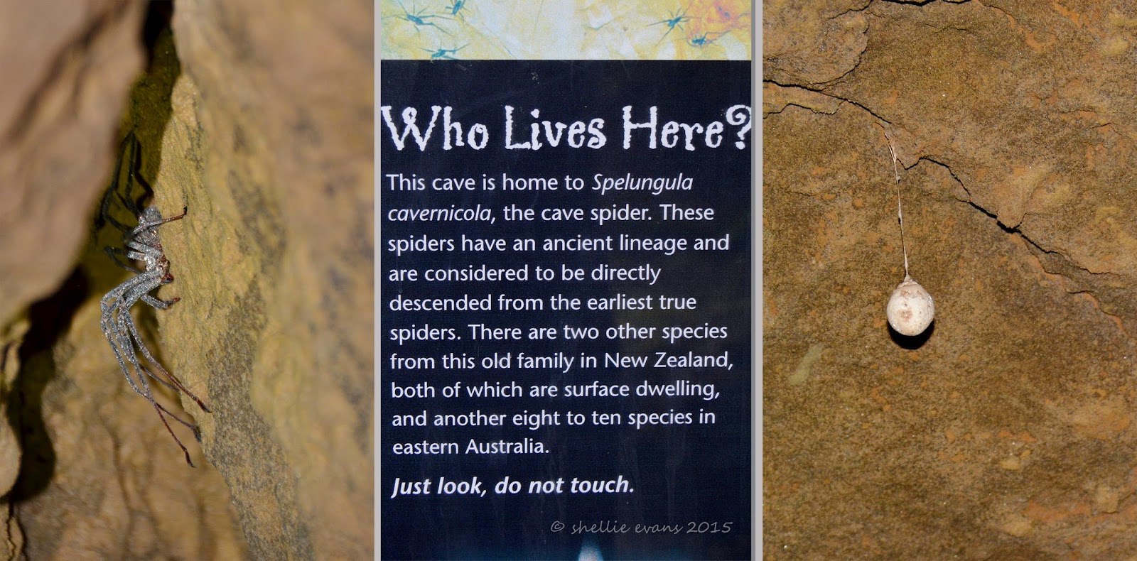
The cave is not very high, perhaps two metres or so and slowly decreases in height as you move into it. Shining the torch into the cracks and gaps in the ceiling not a few inches from our faces reveals the largest spiders you ever saw! Very special spiders, the information panel at the beginning tells us. Large egg sacks also hang from the ceiling.

Remember that it’s pitch black in here and I have to keep up with David whose keen to check out every nook and cranny for wetas & more spiders. Everytime he turns away I’m left in darkness, then he points the torch and there’s a spider or a  weta scurrying away right near my head. I am not happy. Thankfully the wetas are nowhere near as large or as numerous as the ones we found in a cave on the Coromandel.

As if I would!

We make our way to the next cave which is up a stairway to a the level above.


A wooden staircase leads down into the cave.


Box Canyon is one humongous cave, deep, tall, wide and dark. Very dark. From this angle you can also see how the cave got its name.


There are a number of side passages and David’s off exploring again. He squeezes through a passage opening and disappears around a corner. I’m left in darkness and I’m not impressed. Considering David’s aversion to small spaces, I’m surprised he’s so keen to check out the back recesses of the cave.


I take a photo looking back towards the entrance before we round a corner and move further on into the cave looking for glow-worms. There are no wetas or spiders back this far, they tend to like living around the entrance where there’s a bit of light and moisture to attract their prey. Once we’re around the corner we turn off the torch to check the ceiling for glow-worms.

It’s pitch black, not an ounce of light anywhere, you can’t see your hand in front of your face but as our eyes adjust and we look up at the ceiling we see a sprinkle of tiny pin-head sized lights spread across like a miniature Milky Way. Glow-worms! It’s always a delight to come across these tiny treasures when we explore. One day I’ll make the time to set up my camera & tripod to capture them in their natural state. If we turn the torch on them they switch off their lights so it'll need to be a long exposure in the darkness.


It’s too dark for me at the back so I stumble back towards the entrance, checking the sides for anything interesting. I find a tide line, at about my head height, on the stalactites that hang down from the top of the cave. I can’t say that’s very reassuring. It would be some huge downpour to fill this cave, imagine that, one monster swimming pool. At least there's a ladder to help you get out.


We climb back out of the cave, very impressed with what we’ve seen and this is only a small portion of what has been found and explored in the Honeycomb Hill cave system.


Friday, September 5

Archway Islands

The Archway Islands are just off Wharariki Beach at the top of the West Coast (but still within the Golden Bay area), just below Cape Farewell and  not far from Farewell Spit. The beach and islands are part of the Puponga Farm Park as is Cape Farewell and the land surrounding the bottom end of the Spit.

The 1021 hectare Puponga Farm Park is managed by the Department of Conservation and provides a buffer zone to the Farewell Spit reserve. Stock numbers of Romney sheep & Angus cattle are kept to a minimum with historic sites & rare native vegetation fenced off. Any future farm development is limited in order to protect the special features of the area and to allow the public to continue to enjoy the many walking & mountain bike tracks over the farm and along the coast.

From the carpark it’s an indicated 20 minute walk to the beach; we climb a small hill, cross a stile and follow the sandy track through a couple of paddocks and a small section of coastal forest.


As we near the beach the sand track widens and ahead of us we can see huge sand dunes. The path skirts around the edge of a tannin stained stream and heads up the back side of the dunes where it becomes a hard slog walking in the deep and soft sand.


Once at the top an amazing view opens up, the sand it smooth & bright off white (why did I forget my sunglasses!) and just behind the breaker line we can see an island (but no arches).


It’s still hard work crossing the sand so we stick to the ridge where it’s a little firmer. That, plus David didn’t want to destroy the beautifully smooth expanse of pristine white sand down to the water’s edge!


As we move further along the island becomes two and finally we see two arches in the first island. Unfortunately the sun is in the wrong position and the islands are not as clear as I would like.


David has finally found his way down to the water’s edge, he wandered off in the other direction checking for seals and birds on the headland at the top of the bay.


There’s another small arch in the headland at the bottom of the bay.


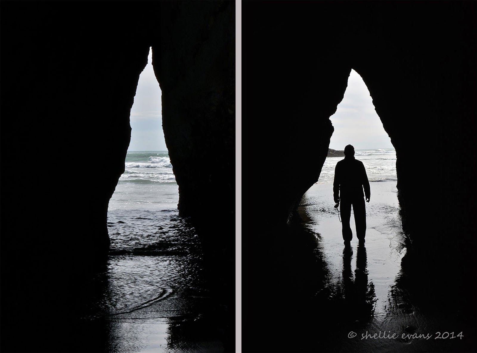
The coastline is very dramatic here at Wharariki beach, along with the islands and archways, there are wave worn cliffs with caves & odd shaped rock stacks. The tide was on it’s way out which allowed us to walk inside this cave. It was devoid of life obviously because it gets beaten up with the wave action at high tide.


The cave is also larger than it looks.


But nowhere near as large as the one around the corner where David checks for skeletons! 


But only finds a large sand bank wall at it’s head and a few full sized dead trees plus a lot of diftwood.


These sea caves would make great shelters if you were shipwrecked, or caught in the rain on your walk. But only as long as it was low tide.


Further on along the beach there’s a “small” outcrop of rocks and I see a couple walking back towards us, we’d seen them earlier having lunch on a log near the beginning of the beach. I speak to them and they tell me that the tide isn’t out far enough for them to get around the rocks so they are walking back to the carpark the way they came.


We continue on and hope by the time we get there we’ll manage to get through, the tide drops very quickly along this coast. We find an archway in the rocks that would be an ideal exit point & even though it looks shallow enough, when a wave crashes in it roars up the narrow channel. And when we catch a glimpse around to the side we see that there are more rocks to clamber over and the pools around them are deep.


We decide to see if there’s a way up and over the rocks and dunes behind and find a narrow overgrown track up through the scrub which then leads down to a slippery sand covered smooth rock face with a big drop off to the beach below. It must have been used a few times by people caught out by the tide and we find a way down further along the slippery rock. Once over the other side we see that there are a multitude of rock stacks and limestone islands with more arches.


And most important of all, looking back we can see that the second island has now revealed it’s huge arch. Wow! What an impressive sight, made all the more impressive because of our scrambling through the undergrowth to get here. Those other people don’t know what they missed.


But I really need low tide as I can’t get out far enough to get the whole arch in view. You can see how far the tide drops by the height of the shellfish on these rock stacks in front of me. No wonder the usually rough west coast wave action has worn the soft rock into so many unusual shapes.


I leave David waiting on the rock bank where we have finally located the orange triangles that indicate the DOC walkway back to the carpark via the longer circular route. We’d been looking for the entrance as we approached the end of the beach as we’d decided not to return back via the dunes. We had walked quite a distance down the beach to have the arches revealed, not something that was pointed out on the information boards back at the start. I wonder how many people just walk the 20 minutes to the beach & think that’s it, as lovely as that view was.


I weave through the rock formations until I manage to find a clear view of the second Archway Island.


And that’s when I hear voices and find another couple trying to find a way through the rock arches back up the beach from where we’d come, they had walked the loop in the opposite direction. I told them about the track over the back of the rocks and left them taking photos under this huge arch.


I moved back to where David was waiting and took one last photo before we disappeared into the bush behind the dunes. It was good that there are people in this photo, it’s gives you great perspective.


Once through the bush we’re out on the farm again and we follow the fenceline up a hill catching sight of the tall red marker posts attached to the fence at strategic points indicating we’re on the right track (pun intended!) At the top of the hill and beside one of the ‘dune’ lakes, Nikau Lake, the islands come into view.


I find a high spot; a bull’s stomping pit (no bulls in sight) to catch the Archway Islands clear of the treeline. Absolutely stunning! And I’m now glad we walked the circuit anti-clockwise as this view would have pre-empted the magnificent islands and the slow reveal of the arches we had from the dunes and beach.


It was another 3kms back to the carpark through undulating farmland, along the way we passed the maternity ward! Well actually we passed through the maternity ward; sheep giving birth right beside us on the track (and not batting a eyelid; them not us), I chopped the back end off that photo TMI!. Others were mothering their babies who looked a little startled to see us but were quickly distracted by the smell of milk. Spring is definitely sprung on the west coast of the South Island.

 
Along the way we passed a second small lake aptly named Dune Lake, these lakes have been formed as separate ice ages and dune movement have disrupted the drainage systems from the low hills behind, some lakes have become swamps, others have dried up completely.

High on a ridge a dying Cabbage tree, one of our most distinctive and much loved trees, gives a stark profile for my photo and a sad reminder that the disease, ‘sudden decline’, is still claiming old & mature Cabbage trees around New Zealand.

Finally the valley opens up and we see the carpark off in the distance. What an awesome walk, well worth doing and one of the best we’ve done on our travels. I’d highly recommend it, just make sure the tide is on it’s way out, I would say leaving the carpark an hour before low tide would be perfect timing. And if you’re a photographer coincide the low tide with late afternoon and the sun will be in the perfect position to light up the islands and the arches.


And I just might have to head back there before we leave so I can get those islands in the right light……watch this space!