Showing posts with label limestone. Show all posts

Thursday, June 4

Sculptures In Stone - Castle Hill

We left Lake Pearson on the last leg of our journey across the middle of the South Island, from the West Coast to the east heading for our next destination, Christchurch.

The road snakes through the dry Canterbury High Country with it’s rugged mountains, jagged bluffs and scree slides, as we head into the Castle Hill Basin and it’s distinctive limestone rock formations.


Castle Hill Basin lies between the Torlesse & Craigieburn Ranges and we stop at Castle Hill Village for a quick look. The village began as a development back in the early 1980s when the owner of Castle Hill Station wanted to create an alpine village beneath the Craigieburn Range as a centre for recreational activities in the area.

The houses are mainly holiday homes and there are no shops in the village. But there are four ski-fields within easy reach, a range of walking and tramping tracks throughout the nearby Craigieburn Forest Park & the Torlesse Tussocklands Park. And along with caving at the Cave Stream Reserve and rock climbing at the Castle Hill & Flock Hill limestone boulder fields, there’s plenty of outdoor activities to keep you occupied.


This ‘sculpture’ sits on the roadside near the entrance to the village- I took a photo for Dad; his golf club in Napier has some huge old tree trunks carved into golfing figures sitting alongside the road. The club paid a few thousand dollars to have them carved- and look they could have saved a few dollars had they seen this guy first (looks like he’s scored a hole-in-one). A $2 hat from Dollar Shop, a bit of bark scraped off and Bob’s your uncle!


Our next stop is just down the road at the well known Castle Hill (Kura Tawhiti) limestone formations. The beautiful and barren Torlesse Range forms a stunning backdrop to the carpark.


We head off towards the boulder pile at the end of the path- they don’t look that big from back here. The rock formations are the water eroded remains of limestone, formed 30-40 million years ago when much of present day New Zealand was covered by the sea.


A track leads off from the main path to a jumble of boulders but we decided to continue on to the main attraction.


While taking a photo I was overtaken by what appeared to be half a dozen ‘Sponge Bob Square Pants’. Disappointingly they turned out to be just plain old rock climbers. That’s their folded crash pads on their backs- although they look rather thin, I don’t think I’d trust falling onto them.


There are hundreds of rocks and dozens of big boulders in this pile.


We decide to follow the climbers along the front of the huge rocks, we might get to see them do some climbing. Now we’re up close we can see how large the rocks are; there are people dancing about on top up there.


We turn a corner and see the Sponge Bobs are disappearing up another steep path and heading to a boulder pile way off in the distance. We decide this will be as far as we go.

David heads up to a fenced off rock to check it out. People have been carving their names in it although I’m not sure whether that’s the reason it's fenced (I mean initials could be carved anywhere in any of the rocks if you so wanted), perhaps it’s unstable. Or perhaps there's some old Maori rock art on it that we failed to see.


I leave David to wander back the way we came while I walk around to the back of the rocks, it's here that I can finally see why the rocks were named Castle Hill, they look like the rocky remains of an old ruined castle.


It’s quite a distance to walk along the back and up on to the rocks at the end and I hope I can get back to the beginning through the back way. Here at the back, you can see that the exposed rocks have a more honey-combed effect from the erosion. You can also see how large the area is; I’ve walked along the fenceline from the back left and up onto the rocks at this end.


Up on top here, it’s quite wide with many tracks in and out of the boulders. There are two school groups visiting and they have ‘disappeared’ in amongst the rocks. One group is playing hide & seek, and the seekers are finding it just about impossible to locate their mates. I’d say it would be very hard to find anybody especially when it came time to call them to leave. Can you spot them?


I’m not sure how much the kids were learning but they were sure having fun in this natural playground.


Although it’s autumn and the day was rather hot, it was still a surprise to find a couple sunbathing on their towels in the lee of a large rock.


I found my way back to the front where David was waiting for me and we made headed back to the carpark. Castle Hill reminded me of the Elephant Rocks we saw last year near Duntroon, although these were on a far grander scale; well worth a visit but give yourself plenty of time to explore.


Our next stop was for lunch at one of the last of the high country lakes along the highway, Lake Lyndon. There’s a freedom camping area here but I’m not so sure it's very welcoming at this time of the year. Talk about a barren, windswept and very dried up lake. I have seen photos of it in the spring though, with snow capped mountains behind, wild flowers in full bloom across the lake front and water fowl feeding along the edge. Never judge a book by it’s cover.


At least it made a fine canvas to show off the rig!
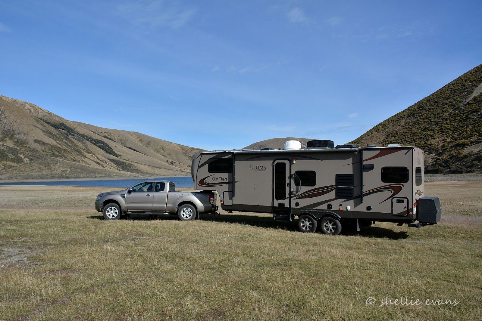

Replete, and keen to hit the road, we headed off to Christchurch, dropping down out of the high country and out across the Canterbury Plains.


Wednesday, May 13

Sea Stacks & a Caveman

Not too far north of Greymouth there’s a very special place that not too many people have visited or in fact know about- the Motukiekie Rock Stacks. The stacks can be seen from a couple of vantage points along the main highway which follows the coastline, but it’s just about impossible to work out a way to get down to them through the steep bush covered bluffs that rise from the beach below - unless you know where to look that is. And nope, I’m not telling.


Motukiekie Rock Stack photos appear in numerous West Coast tourist brochures and websites promoting the coast but their location is always omitted. DOC also make no mention of them in their brochures. There’s a good reason for this, it’s actually quite a dangerous place, not only are the limestone rocks unstable but the beach can only be visited about an hour either side of low tide. There is no escape if you get caught by the tide and especially if it’s the usual rough west coast sea.


I have long had Motukiekie on my list of places to visit, I’d heard about them from a photographer friend a few years ago. We’d passed the stacks on our way south(in the rain) to Lake Kaniere a few weeks ago so I knew that when we made it back to Greymouth the stacks would be on my must do list before we left the area. There was just one day out of our four where the tide suited a visit and luckily the day was sunny and calm.

I also had no idea where the access track was but struck it lucky when I spied a small sign that quite possibly only a New Zealander would know what it was for. We were in for a ‘treat’ as we made our way down a rocky, overgrown, steep & slippery track. After maneuvering along a rocky ledge we had to hold onto an slippery moss covered, old knotted rope and clamber down a steel ladder to get to the next level. Obviously DOC don't oversee this track! David was a bit worried it would break.

Eventually the track opened out onto a large rock ledge where another knotted rope (and no ladder) gave us access to a rock platform just above a stony beach. The rope David is holding was near the one we came down. This one gave access through a hole in the rock to a narrow canyon from where a stream flowed. Unfortunately David needs to eat a few more Weet-bix for breakfast, he just could not manage to pull himself up into the hole so we have no idea what sights awaited us behind the rock.


The stream that flowed out from the canyon landed on the smooth rock platform and then flowed down over the side in two places and disappeared into the stony beach. After working up a thirst trying to climb the rope David helped himself to the cold crystal clear water, it was very refreshing. Our track came down the bush covered bluff to the left behind him, the other rope is in that dark spot amongst the flaxes.


You can now see how high the bluffs are along the beach. I bet you thought it didn’t look too high in those first photos from the lookouts. Now you can see why this is a difficult place to access.


We decide to walk south first- the stacks are to the north- I’d had a fleeting glimpse of an archway in a rock that sat at the mouth of a creek we’d crossed on the road earlier. I suspected it was the same rock that a coffee-cart guy had told us about. We'd got talking to him at the old Fox River bridge earlier in the trip.


Motukiekie is a hidden wonderland, the beach is absolutely stunning; along with the sea stacks there are colourful cliffs, sandy beaches, rocky formations, rock pools, and large boulders scattered about as if they’d been thrown over the top by a giant. And then there was the very tall and very unusual chimney stack perched on the edge of a cliff. Imagine if you were underneath that in an earthquake. The outgoing tide was still swirling around our feet as we walked along.


This bluff had more than colourful cliffs to show off….


We did a double-take to see a guy with a small back-pack sitting in a cave, a beer in one hand and what looked like a feed of mussels in the other. A real life caveman! Where the hell did he come from?


We waved out, and later David stopped to talk to him on our way back. He lived in Greymouth and had walked in from a beach further on where he’d left his pushbike. He said he was just relaxing with a beer watching the ocean- we thought he was going to stay the night but no, he was just visiting. From his lobster colour it looked like he’d had his shirt off a little too long…. in more ways than one. A very weird encounter indeed…but I guess each to their own.


Further on another chimney stack appears in front of us and the sand changed to boulders, there are deep rock pools out to the right. This must be where our Neanderthal found his mussels. Did you spot David in the photo?


The chimney stack has a opening where it meets its limestone neighbour (see comments below for an a correction of the rock type), its a small cave that opens onto the creek behind, the creek where I’d seen the archway.


This is our destination, 10 Mile Creek, and you can’t see it but the highway runs along the side about halfway up the bush on the left, it runs inland for a few hundred metres before crossing the gorge and coming back out to the coast high up on the right (out of shot). Can you see the power lines strung across the creek near the top?


And this is the large rock that I’d spotted with an archway in it. I really needed David in the photo to give you an idea of the size but he’d shot through. It was reasonably large though, about 1.5 metres high.


Not only did it have an arch it also had a large hole in the centre, which is probably what I spied from the road.


Across the creek (which was ice cold) I could see the large flat slabs of stone we’d seen from the first lookout- check back to the first photo. They look like a stack of fallen dominoes. I would have loved to explore further along but it was getting late and the tide had turned so I reluctantly headed back up the beach after David.


The sun was low in the sky and the sea spray created a haze over the stacks.


The many textures of Motukiekie…


You can let your imagination run wild with the formations and the shapes the sea stacks make….


Give us a kiss….


Trumpeting elephant…


Dennis the Menace (David’s suggestion) keeps a wary eye on a couple of photographers who were setting up to catch the sunset. We find their motorhome parked beside our ute when we return, I guess we made it easy for them to find the track. I hope they have torches, I wouldn’t like to make my way up the track once the sun goes down.


This stack has a small hole in the rock through which a sunbeam is shining.


At the northern end of the beach there are more waterfalls which flow over the rock shelves onto the beach and high up in the coastal flaxes and bush is the house I’d love to own! What an awesome place to live. I’m still not sure what my first love is; windswept tussock covered mountains or a wild west coast and especially a wild west coast in the winter. I love isolated and rugged coastlines, when you can tuck up inside with a roaring fire and the howling wind and crashing ocean outside. Motukiekie would suit me just fine.


One last pano of the Motukiekie Rock Stacks. What a thoroughly wonderful place to visit. I WILL be back.


We headed home as the sun set, both quiet and reflective after our visit. What an incredibly beautiful and special place, another highlight of our journey.


If anybody would like to know where the track is please send me a note via the email contact form from the right hand column of the blog.


Thursday, February 26

Sawcut Gorge: Part 2

After wading through water, crossing the Waima River at least 30 times, clambering over rocks and boulders in the river bed for the last hour and a three quarters, we took a short steep bush track up and over and into Isolation Creek where the Sawcut Gorge is located. For another 5 minutes or so we scrambled over more boulders before finally turning a corner to find the Sawcut Gorge right in front of us looking very narrow and like a deep cut in the rock wall. Duh- hence the name Sawcut.


Sawcut Gorge is New Zealand’s finest slot canyon and comparable to the slot canyons of Utah in States. The chasm is 50m deep, 50m high and in places only 2m wide.

It’s not until you see a person near the entrance that you get an idea of how impressive the canyon is.


The “Sawcut” itself is a short and narrow passage where Isolation Creek has eroded through a 50m high wall of limestone, leaving a unique slot that’s higher than it is long.

Inside the canyon the water is cool and clear and free of algae (it needs sun to grow), we wade through marveling at the smooth, curved and colourful walls….


.....and the plants that are hanging off the sides in places. David stops to talk to three women coming back through the canyon…..


And I wait until they pass so I can catch their silhouette against the opening & before they exit ….


They also stop to take photos of each other and then they are gone…


David carries on and by the time I catch him up he has settled on a rock waiting to have lunch. The ‘party’ we had been told about were also having their lunch on the rocks just outside the canyon. With little space, we had to walk right through the middle of them to get past….


As did these girls that came through while we were resting. I’m sure they were on a ‘hen party’ weekend, they were carrying water pistols & bow & arrows, some had cowboy hats on and others Indian feathers in their hair bands. They were headed for Isolation Hut, a 6 bunk DOC hut an hour further on up Isolation Creek, I hope there are none others up there otherwise they’re going to be sharing a bunk or two. I walked up the creek after them for another couple hundred metres or so to see if the boulders got any smaller. They didn’t.


After a short rest and a bite to eat, David went ahead of me back through the slot so I could get a silhouette shot of him as we passed through. Two guys were approaching from the other end, both wearing gumboots (wellington boots). Well they had been wearing gumboots, they were holding them and wading through the water, fancy coming all this way wearing gumboots! No grip whatsoever, they must have struggled walking over all those rocks in the riverbed and have sore feet when they did have to remove the boots.

One of the guys had a gun slung over his shoulder, they told David they were heading for the hut where they were going to go hunting for deer. Ah-oh, 2 + 5 + any others = too many people, not enough bunks.


I waited for the guys to pass me before heading out, David was patiently waiting for me. Well actually he was waiting and checking, yet again, his tracking app on his phone- David will never be lost in the bush!


We headed off down the creek, back over the bush track, around the corner and back into the Waima River bed.


The return trip is just as confusing and just as demanding. Nothing looks familiar. Except DOC’s orange triangles pointing the likely way to go.


The stark white limestone boulders are very impressive, they look like blocks of ice at the end of a glacier.


We come across two groups of people making their way to the gorge, the guy on the right is filling his water bottle, the group at the back are having a water fight, cooling down on a hot afternoon. They still have around a 40 minute walk to get to the gorge and it about 3pm. Unless they hurry up they’re going to be walking back down a cold riverbed. The sun is due to disappear behind the bluffs above us.


Back behind us another two groups are making their way back to the carpark. The front group told us, when we saw them later at the cars, that they stopped to have a swim in a large pool- the one we had waded through on the way up. The one with the ‘pet’ eel. They didn’t mention an eel encounter so perhaps he has hibernated through the hot summer.


Part of the track passes through the bush on the side of the river, it’s narrow and steep and requires a bit of maneuvering around and holding onto tree trunks.


It is with some surprise we come up behind a family group gingerly picking their way over the rocks. A couple with older parents, a toddler in the backpack and a 3 year old, holding his own over the rocks. They proudly tell us they’ve been to the Gorge and their son has walked the whole way. We haven’t the heart to tell them that they would have only made it to the reserve where the boulders are big and the bluffs are vertical above the river. It probably looked like a ‘Sawcut’ gorge.


The boulders make way for rocks and the walking becomes easier. We look back up the river and say a farewell to Isolation Hill.


Just a handful of crossings and near level ground ahead of us and we’re back at the car. I wonder if the slips that we see happened in the ‘quakes. And I wonder how long it took for them to be cleared.


Finally four and a half hours after setting off we were back at the ute. We sat on the tailgate in the hot afternoon sun with a welcome cup of tea in hand, reflecting on the walk. With sore feet and stiff legs from all the rock hopping (and for me, a sore arm from carrying my camera the whole way) we decided that while it wasn’t exactly a gut-busting walk, it was very challenging.

You definitely need a walking pole to steady yourself climbing up and down the rocks and to check position & stability of them in the water, and the water depth in some of the deeper pools. A sign at the homestead, by the visitors book, made me smile- ‘Please leave your walking sticks in the river bed where they belong’. It was just as well I didn't get a bunch of flowers for our anniversary the other week, I got a lovely new walking pole from David! I had my hands full; pole in one hand, camera in the other plus sunglasses on my head and pack on my back, it was all a bit of a juggling act!

We also found our Teva enclosed sandals ideal for grip on the rocks and for the river crossings; the gravel only occasionally getting caught under our feet but easy to flush out with the river flow while still walking. And make sure you wear sunglasses on a bright day, the glare off the white rocks is brilliant.

I would highly recommend this walk if you are a reasonably fit and active person (who doesn't have a gammy leg or knee) but personally I wouldn’t like to do it any earlier that mid to late summer; the water level would not only be higher it would also be very cold before then.

And you’d miss out on seeing the 'Naked Ladies'.