Monday, February 15

Rarest Wader in the World

Catch-up

After visiting dozens of lakes and waterways around the MacKenzie Basin and seeing many different birds which included a Black Stilt family with a chick & one hybrid parent, another adult bird defending it’s nest/chick from a hawk and two juvenile Black Stilts up close, we had yet to see an adult Black Stilt up close.

So it was a great thrill when we finally managed to locate not one, but two very confiding adult Black Stilts/KakÄ« feeding in a shallow pond overflow on farmland not too far from Twizel.


Not only were they happy to carry on feeding but I managed to get very close without disturbing them.


Going by the flattened grass track leading to a fence that separated the birds from the road, I got the feeling that these two are very much used to weird humans crouching and crawling through the grass with a camera lens stuck to their face.


Intensive conservation management of the endemic (found nowhere else in the world) Black Stilt began in 1981 when the population had declined to just 23 adult birds. Despite this management the Black Stilt still remains the rarest wading bird in the world, with fewer than 100 breeding birds.


Over 150 captive bred juvenile black stilts (a season record) have been released into the MacKenzie Basin area this past breeding season which should increase the breeding adults over the next 2-3 years, providing they survive predation and the harsh winter environment they live in.


Unlike other birds that make the braided rivers of  the South Island home, the majority of black stilts don’t migrate to warmer climates for winter.


We visited the birds twice while we were staying at Lake Ruataniwha and I’ll certainly be checking in on them again the next time we pass through. We also located another two adults further down the road but they were a lot further away than these two.


That’s another bird we can tick on our virtual list. And it was well worth the wait and effort in finding them, they are a stunning bird.


Friday, February 12

Stooks in Winton

Real-time

We're now parked up at our Winton family's home- though not in our usual spot in the drive. Since our last visit a pesky caravan has taken over the prime parking spot and we've been relegated to the front lawn. Which is just fine as there's a bit of shade to protect us from the warm sun and lovely soft grass under foot. I'm just worried we're going to kill the lawn if we stay too long.


After leaving Monkey Island, we drove straight through to Winton. We were intending to move & stay a couple of nights at Colac Bay which is just over the hill from Monkey Island. But the wind had picked up again and it was raining quite heavily (although that cleared by late morning) so we decided to give Colac Bay a miss and head straight to the family a few days ahead of schedule.

Just outside Winton we came across the unusual sight of paddocks full of oat stooks- it may be more common than I think but I've never seen stooks in NZ before, especially on such a grand scale. The sheaves of oats are stacked like this to protect the unthreashed grain from moisture until it can be picked up and taken in for long-term storage. There were about two dozen flat-deck trailers placed at equal intervals throughout the paddock ready for the grain to be collected.


I returned to the paddock the next day hoping to catch the farmer collecting the grain and was lucky to time it just right. With Winton's historic water tower in the background this shot could have come straight out of early 20th century colonial New Zealand. 


21st century machinery soon shattered that image! 


There were a number of old vehicle wrecks in the paddock and beside a nearby shed that made interesting subjects to shoot... 


Especially when I gave them some rustic treatment...


We'll be here in Winton for a few days and then off to Dunedin to catch up with my sister and family who live in Whangarei; my niece & nephew are returning to uni in the city and their parents are helping them settle back in. It'll be good to see them all again.

Then it'll be back to the front lawn again for a few more days before we head off on our big overseas holiday....


to....


wait for it....


...Stewart Island!


Thursday, February 11

Lake Ruataniwha - MacKenzie Basin

Catch-up

Our next stop after Mt Cook was at Lake Ruataniwha, an artificial lake just south of Twizel in MacKenzie Country. Twizel often gets a bad rap because of it’s location and past history- it was founded in 1968 to house construction workers on the Upper Waitaki Hydroelectric Scheme and was meant to be a temporary town, most houses were prefabricated and intended to be portable. It was to revert to farmland once the hydro work was completed but in 1983, as the project was winding up, residents successfully fought to save the town. Twizel is a now a service and tourist town for the many visitors to the MacKenzie Basin.


Personally I love this area, I love the remoteness when you leave the main road, the dry bleached high country, long lonely roads, the surrounding mountains and the beautiful turquoise blue canals and lakes. The salmon fishing is reputed to be pretty good too- we are yet to find this out though.


We usually stop at the NZMCA park beside the Ohau B canal but decided a change of scenery was in order. And just across the lake from the NZMCA site (centre right of the small mound)- is a freedom camping area near a stand of trees and just a few steps from Lake Ruataniwha.


We parked between the pine trees in the shade because as you can see the weather was perfect and the sun very hot! We left any bad weather behind at Mt Cook for a few days.


We stayed for a few days and explored some of the areas we hadn’t covered on our previous visits. We also went looking for the elusive adult Black Stilts.


Other Movanners came and went, and often we arrived home after exploring to find new neighbours. I love this time of the year (early December), the weather is fine although crisp & cool in the morning, and it’s a few weeks before the silly season kicks and the traffic get heavy, both on the roads and in the camping sites.


We shared the grove of trees with this memorial; before the hydro scheme and the dam that created Lake Ruataniwha, the Ohau River flowed past here.


Don’t worry he’s not doing what it looks like- it's another hapless fisherman trying his luck amongst the lupins.


Another grebe’s home base was the length of lake front below our van (we must have seen the total NZ population on our travels) and it was fun to watch him (or her) through our tinted windows- our own personal bird hide- swim up and down all day fishing and relaxing without being aware he was being watched. Whenever I stepped outside to photograph him he’d dive and disappear.

Other wildlife included my new favourite bird, the Black Fronted Tern, who did circuits of the lake corner and rested on the ‘camping regulations’ sign post nearby. A mother NZ Scaup and her two ducklings also shared the same length of lake edge with the grebe, both keeping a wary eye on each other and on me.


You’ll remember this shot from a quick blog post I did at the time to say we had arrived at the lake. 


David fishing as the sun went down. He didn’t catch dinner though.


I’ve been on a half-hearted mission for some time to catch the Southern Lights; the Aurora Australis. I follow a couple of Facebook pages and receive alerts when the solar activity around the sun is high; this usually means the lights will be playing loud & clear a few days afterwards. You will be surprised to learn that the lights actually play a lot more often than not but they’re not usually visible to the naked eye. They play at many different strengths, sometimes for only brief spurts, other times, for most of the night.

As you can see from the following photos I had a go at catching them while parked at Lake Ruataniwha. I knew there was going to be an issue because of the salmon farm lights across the lake (right), the bright blue lights on the floating boom in front of the spillway (centre) and the passing traffic on SH8- that’s a large truck and trailer with two rows of red lights down the sides. Made a pretty cool photo though.


So far on our travels I’ve missed the best activity, there’s been a few times when we weren’t far from a good showing but mostly we’ve just missed it or it arrives just after we’ve left a good site with excellent views facing south. Winter is also the best time and often it’s just been too cold to venture out in the middle of the night- I’m not that fanatical about them yet- unlike some who chase them night after night and are up all night.

To photograph the aurora you need a dark sky with no moon and definitely no artificial light. It helps to have a water body in front of you for reflection and a good unobstructed view to the south, it also adds interest if you have a jetty, boat shed, lighthouse or something similar in the foreground. You need a wide angle lens, large aperture, high ISO and it’s a fine balance with the shutter speed- too fast and not enough light gets in, too slow and you pick up star trails of varying lengths. You also need to focus before it gets dark otherwise you’re shooting blind, this one is not sharp at all but there’s a hint of purply-pink aurora.


I gave up after a 20 minutes or so, it was never going to work not least because there was too much rustling going on in the grass nearby- I think I need to stand on a table or seat or something and wear my gumboots(wellington boots) instead of my Crocs- it’s pitch black and I had visions of water rats or weasels shuffling about my feet. It’s also 12am and getting cold by the minute.

I like this shot because I caught a shooting star; I didn’t see it until I uploaded the photos. One day I’ll get serious and one day I will shoot the Southern Lights.


In the meantime I think I’ll stick to day-time shots (taken from the same position as the night photos).


There was quite a bit of activity on the lake and near our camp site over the weekend while we were there. Children’s birthday parties and boating families enjoying BBQs. This dodgy looking rust bucket of a vehicle took the birthday boy and his guests for a few spins around the reserve and along the top of the stopbank. I’m not so sure I’d be letting my son ride in this contraption, it was all good fun but it really looked like an accident waiting to happen.


We were woken early most mornings by very loud voices coming across the lake- it took me a few moments to work out where they were coming from initially; mega-horns on board a number of small dinghies chasing rowing teams along the beautifully smooth lake.


Early morning and again early evening most days there were half a dozen crews practicing on the lake. Lake Ruataniwha is the home of South Island rowing and many regattas, both national & international are held on it. The Meridian Rowing Centre is just over the rise from where we’re parked and marked race lanes stretch nearly as far as the eye can see up the lake.


Towards the top of the lake there are a number of boat ramps and picnic areas below the road level and another freedom camping area on a plateau above and overlooking the lake.


I walked over to the main road and across the spillway bridge so I could take a summer photo of the historic old Iron Bridge that sits below the road.


Here’s the last shot I took of it when I drove up from Winton to see the ‘big snow’ back in June; it’s amazing how much a scene changes through the seasons.


Monday, February 8

Tasman Glacier & the Blue Lakes

Catch-up

We had one last walk to do in the national park before we headed back down the valley, a short walk to view the Tasman Lake & Glacier on the east side of Mt Cook. The forecast wild weather front hadn’t arrived overnight which was fortunate for us; it did arrive late in the afternoon by which time we were well on our way to our next stop.

We left ‘Out There’ in the carpark (with hi-vis vest on a large rock below out hitch just in case someone blocked us in before we returned- we need one of those pop-up orange cones) and drove back down Hooker Valley a short distance before crossing the single lane Hooker River bridge and following the Tasman Valley Road up the valley. Ahead of us is Mt Johnson with Mt Cook hidden to the left, to the left and below of the ‘Give Way’ sign you can see the Tasman Lake moraine wall that we’ll be climbing shortly.


We find a spot in the busy carpark and head up the path past the Blue Lake Shelter. There’s a group of people that appear to be very overdressed for such a short walk…I think they must be in a tramping group doing the round of walks in the area as I do recall seeing some of them on the Hooker Valley walk the day before.


The view back down the Tasman Valley is fabulous even from the beginning of the track.


It’s a fairly steep climb up dozens of stairs over a rise of 100 metres to the top of the moraine wall…


…but you can take your time and use the stunning views as an excuse to take a breather (she says as younger, fitter people fly past at pace)


As we climb higher one of the Blue Lakes comes into view.


And the spectacular view behind and down the valley is getting even better…


…further on the two smaller Blue Lakes appear. In the mid 1880s when the Blue Lakes were named, they were fed by turquoise glacial meltwater filtering through the moraine. The lakes were a popular swimming spot in the summer and skating rink in winter. The Tasman Glacier has now shrunk and water no longer flows from the glacier into the Blue Lakes. The warmer rainwater that now feeds the lakes supports green algae making the Blue Lakes green. They also now support a good population of native fish.


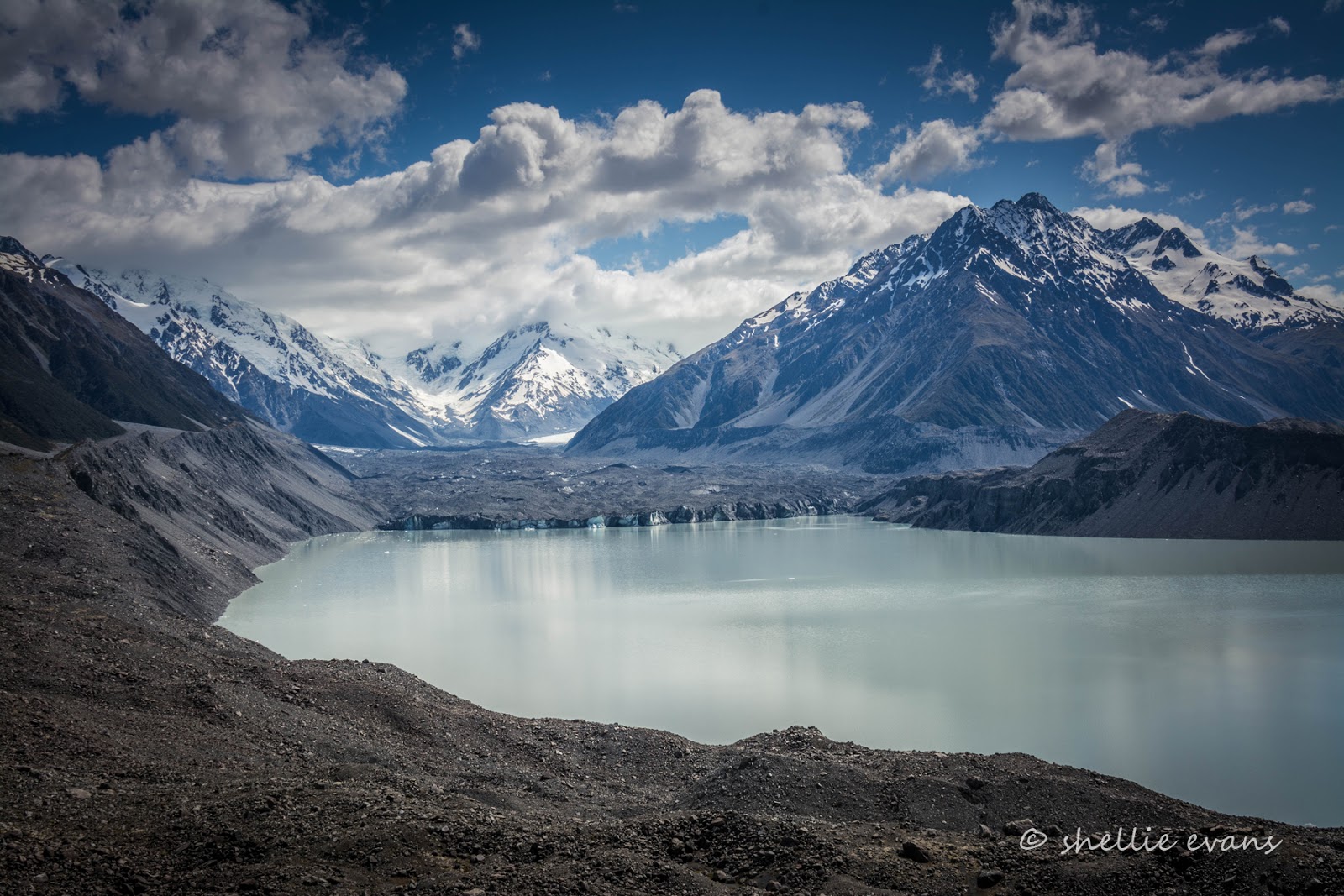
Finally we reach the top of the wall and there spread out in front of us is the magnificent Tasman Glacier and lake. What a stunning sight and what a contrast against the view down the relatively green valley just over our shoulder. It was worth the slog.


The dirty grey blue terminal face of the Tasman Glacier is easy to see and I can see a few icebergs floating in the lake, close to the wall.


At 24km long (and 600mtres deep) New Zealand’s longest glacier winds its way down the Southern Alps ending at the 18 square km terminal lake. Global warming has (and is) taking a toll on New Zealand glaciers, the Tasman Glacier is retreating at a rate of 500-800 metres a year. In recent years the glacier has changed from a 'melting' to a 'calving and melting' terminus, resulting in a terminal lake that is rapidly increasing in size. On either side of the terminal lake, lateral moraines rear up 100 metres to remind us of the scale and greatness the glacier has reached in previous times – the last ice age finishing in just 1890!


As the glacier retreats in length it also drops in height. This meltdown results in an accumulation of debris originating from within the glacier being left atop the huge river of ice. The layer of rock on top of the glacier provides some spectacular rock fall as the ice continually melts away from beneath it.

Although a surprise to many- David included, he’s not too keen on a muck-metal grey glacier- the messy array of dirty moraine on top of the Tasman Glacier isn't such a bad thing. The layer of rubble acts as an insulator for the ice below, protecting it from the harsh sun's rays and assisting in the preservation of what is undoubtedly the most precious resource on earth – water!


For those that would like to know the peak names on the panoramic shot above, here’s the information board (click to enlarge any of the photos for a more stunning vista)-


Below us we can see a tiny turquoise pool in the moraine on the side of the lake, this is what the Blue Lakes would have looked like all those years ago when glacier meltwater filtered through to them.


Across the lake and very near the Tasman River outlet there are more icebergs.


Just when you think you’re by yourself you look over your shoulder and a dozen people have arrived, including a tiny baby, all stunned into silence by the breathtaking views!


From the top we can see where the Tasman River leaves the lake and winds it's way down the valley, joining the Hooker River and other smaller rivers and streams along the way to eventually flow into Lake Pukaki, a good 20kms away.


The magnificent Tasman Valley, Aoraki/ Mt Cook National Park.


More selfies taken to send home to far away lands- but how impressive would this shot be to those that live in smog-clogged, muti-million people populated cities and/or non-mountainous countries alike. And the best bit? There was hardly any work in getting to this prime spot either.


Time to return to the carpark and head back to White Horse Hill to de-camp..


…back across the Hooker River with the Sealy Range behind…


…and a short diversion for a close up of the Heritage Hotel and the statue of New Zealand’s most famous mountaineer, Sir Edmund Hillary. There were far too many people milling about inside the hotel for my liking…


…so I grabbed a shot of the view that is seen from many of the hotel rooms- straight up the Hooker Valley to Mt Cook in the centre, except this day she has her head in the clouds. But what a view to wake up to on a clear day.


Then it’s back to the car-park to hitch up, and down to what must be one of the most scenic dump stations in New Zealand, to empty and top up the water.


Then off down the road, past beautiful Lake Pukaki, and back to civilization and the main road traffic chaos. After a stunning couple of days in the heart of the Southern Alps.