Showing posts with label moraine. Show all posts

Monday, February 8

Tasman Glacier & the Blue Lakes

Catch-up

We had one last walk to do in the national park before we headed back down the valley, a short walk to view the Tasman Lake & Glacier on the east side of Mt Cook. The forecast wild weather front hadn’t arrived overnight which was fortunate for us; it did arrive late in the afternoon by which time we were well on our way to our next stop.

We left ‘Out There’ in the carpark (with hi-vis vest on a large rock below out hitch just in case someone blocked us in before we returned- we need one of those pop-up orange cones) and drove back down Hooker Valley a short distance before crossing the single lane Hooker River bridge and following the Tasman Valley Road up the valley. Ahead of us is Mt Johnson with Mt Cook hidden to the left, to the left and below of the ‘Give Way’ sign you can see the Tasman Lake moraine wall that we’ll be climbing shortly.


We find a spot in the busy carpark and head up the path past the Blue Lake Shelter. There’s a group of people that appear to be very overdressed for such a short walk…I think they must be in a tramping group doing the round of walks in the area as I do recall seeing some of them on the Hooker Valley walk the day before.


The view back down the Tasman Valley is fabulous even from the beginning of the track.


It’s a fairly steep climb up dozens of stairs over a rise of 100 metres to the top of the moraine wall…


…but you can take your time and use the stunning views as an excuse to take a breather (she says as younger, fitter people fly past at pace)


As we climb higher one of the Blue Lakes comes into view.


And the spectacular view behind and down the valley is getting even better…


…further on the two smaller Blue Lakes appear. In the mid 1880s when the Blue Lakes were named, they were fed by turquoise glacial meltwater filtering through the moraine. The lakes were a popular swimming spot in the summer and skating rink in winter. The Tasman Glacier has now shrunk and water no longer flows from the glacier into the Blue Lakes. The warmer rainwater that now feeds the lakes supports green algae making the Blue Lakes green. They also now support a good population of native fish.


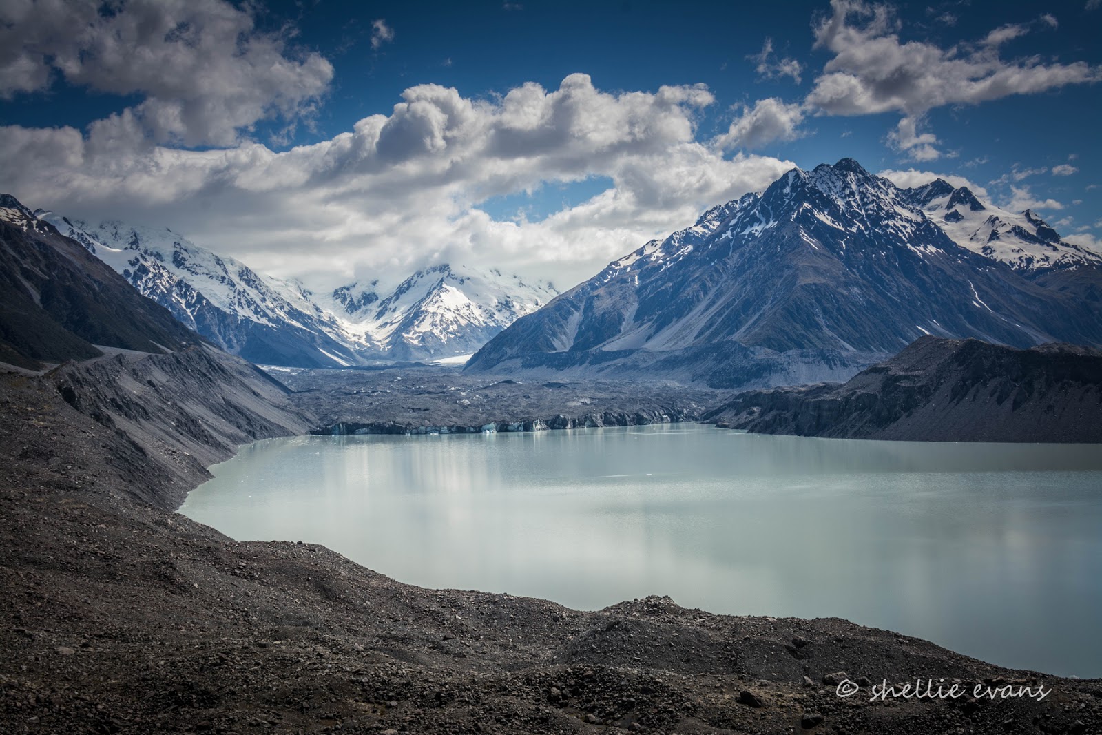
Finally we reach the top of the wall and there spread out in front of us is the magnificent Tasman Glacier and lake. What a stunning sight and what a contrast against the view down the relatively green valley just over our shoulder. It was worth the slog.


The dirty grey blue terminal face of the Tasman Glacier is easy to see and I can see a few icebergs floating in the lake, close to the wall.


At 24km long (and 600mtres deep) New Zealand’s longest glacier winds its way down the Southern Alps ending at the 18 square km terminal lake. Global warming has (and is) taking a toll on New Zealand glaciers, the Tasman Glacier is retreating at a rate of 500-800 metres a year. In recent years the glacier has changed from a 'melting' to a 'calving and melting' terminus, resulting in a terminal lake that is rapidly increasing in size. On either side of the terminal lake, lateral moraines rear up 100 metres to remind us of the scale and greatness the glacier has reached in previous times – the last ice age finishing in just 1890!

As the glacier retreats in length it also drops in height. This meltdown results in an accumulation of debris originating from within the glacier being left atop the huge river of ice. The layer of rock on top of the glacier provides some spectacular rock fall as the ice continually melts away from beneath it.

Although a surprise to many- David included, he’s not too keen on a muck-metal grey glacier- the messy array of dirty moraine on top of the Tasman Glacier isn't such a bad thing. The layer of rubble acts as an insulator for the ice below, protecting it from the harsh sun's rays and assisting in the preservation of what is undoubtedly the most precious resource on earth – water!


For those that would like to know the peak names on the panoramic shot above, here’s the information board (click to enlarge any of the photos for a more stunning vista)-


Below us we can see a tiny turquoise pool in the moraine on the side of the lake, this is what the Blue Lakes would have looked like all those years ago when glacier meltwater filtered through to them.


Across the lake and very near the Tasman River outlet there are more icebergs.


Just when you think you’re by yourself you look over your shoulder and a dozen people have arrived, including a tiny baby, all stunned into silence by the breathtaking views!


From the top we can see where the Tasman River leaves the lake and winds it's way down the valley, joining the Hooker River and other smaller rivers and streams along the way to eventually flow into Lake Pukaki, a good 20kms away.


The magnificent Tasman Valley, Aoraki/ Mt Cook National Park.


More selfies taken to send home to far away lands- but how impressive would this shot be to those that live in smog-clogged, muti-million people populated cities and/or non-mountainous countries alike. And the best bit? There was hardly any work in getting to this prime spot either.


Time to return to the carpark and head back to White Horse Hill to de-camp..


…back across the Hooker River with the Sealy Range behind…


…and a short diversion for a close up of the Heritage Hotel and the statue of New Zealand’s most famous mountaineer, Sir Edmund Hillary. There were far too many people milling about inside the hotel for my liking…


…so I grabbed a shot of the view that is seen from many of the hotel rooms- straight up the Hooker Valley to Mt Cook in the centre, except this day she has her head in the clouds. But what a view to wake up to on a clear day.


Then it’s back to the car-park to hitch up, and down to what must be one of the most scenic dump stations in New Zealand, to empty and top up the water.


Then off down the road, past beautiful Lake Pukaki, and back to civilization and the main road traffic chaos. After a stunning couple of days in the heart of the Southern Alps.


Thursday, January 28

Magical Mountains - Kea Point

This will be the last post for a few days. The rain has finally stopped (9 days give or take a couple of afternoons) and we're off to the wops and no reception again. 

Catch-up

I was so enthralled with the mountains and the beautiful scenery right outside the van I couldn’t sleep the first night we were parked up at the White Horse Hill DOC camp at Aoraki/Mt Cook National Park. This was the magical view from my bedroom window, I left the blind up so I could see Mt Sefton sparkling and shimmering in the moonlight at the end of the valley. In the end, with sleep eluding me, I thought I might as well make the most of it. I dressed and got my camera gear together and stepped outside to take some night shots in the peace and stillness of a calm and clear night. This one was taken at 2am!


The temperature was very mild considering the time and where we were, beside the Southern Alps, the night sky a beauty with a million twinkling stars above. Looking down the valley towards the Tasman River plain and Lake Pukaki.


I crept about the carpark trying to keep the gravel crunch of my footsteps to a minimum, there were a few sleeper vans parked in the day carpark with us. I’m sure if any of the others sleeping soundly in the cars had looked out and seen me, they’d wonder what the crazy lady was doing moving about their vehicles and shining a light over the 5th-wheeler. I did some light painting of the van with my head torch, watched the moon rise above the mountains behind me and took more photos of Mt Sefton in the beautiful moonlight.


I returned to bed but still couldn’t sleep and as I watched dawn approaching I was up again and back out with my camera to catch sunrise. I hadn’t seen Mt Cook yet but I knew it was visible from Kea Point and I was hoping to get there to catch the pink hue of sunrise on our tallest mountain.


I thought I’d walk to Kea Point, the 20 minute walking track exited the carpark right beside our van. But I took too long getting ready and taking photos of Mt Sefton again.  Before I knew it the sun was rising without me. Blast! Never mind, I managed to catch the pink hue on Mt Sefton instead. These were taken at 5:30am.


I hurried on up the track anyway, startling a number of rabbits along the way. The track passes through landscape that was formed in 1913 when a stream cut through from the Mulleur Glacier to the original Hermitage Hotel site, damaging the building and forcing the new hotel to be built further down the valley and off to the side. A bonus was that the hotel now has fantastic views of Mt Cook.


A short time later I rounded a corner to see my first close up view of the majestic Aoraki/Mt Cook towering above the ridge ahead of me, the sun warming it’s eastern slopes.


Beautiful Aoraki/Mt Cook lies in the Southern Alps, the mountain range that runs the length of the South Island, and is New Zealand tallest mountain at 3724 metres.


The Kea Point walk climbs gradually up through sub-alpine grasslands and scrub to finish at a lookout platform on the edge of the Mueller Glacier moraine wall.


The platform is high above the Mueller Glacier Lake, the opposite moraine wall and Mt Cook behind, are across the wide expanse.


Across the lake to the right and at the base of Mt Wakefield(2012m) is the Hooker River outlet, the river flows from the Hooker Glacier Lake which is at the top end of the Hooker Valley and at the base of the Hooker Glacier, on the west side of Mt Cook. The Tasman Glacier is on the east side.


There are stunning 360 degree views from the viewing deck.


There’s Mt Sefton(3151m) and The Footstool (the right hand peak) and the Mueller Glacier which is around the corner and out of view. High up on the sides of Mt Sefton I can see the dirty blue of glacial ice. There’s nothing here to give these photos scale but believe me everything is on a grand scale- extremely high and and very deep. A person in the valley below would just be a speck on the landscape.


Behind me I can see the track up to the Sealy Tarns, a gut-busting near vertical track to the top of the Mueller Ridge which takes 3-4 hours return for a fit person, everyone else it would be all day…if you made it. The track runs up the deep gully to a lower ridge and then you can see it tracking along the top, apparently there are some amazing views from up there but you won’t be seeing them from me anytime soon. I spot a moving dot of blue and zoom in to see a person stepping it out, the only sign of life I see for the next couple of hours.


But it’s Mt Cook that steals the scene and I can’t stop clicking especially when the clouds suddenly streak out from behind it.


I have the whole place to myself which is surprising, considering the amount of people back in the camp and the fact that it’s now approaching 7am on what is going to be a beautiful day. I sit there in the peace & quiet contemplating this magical place and soaking up the atmosphere and the cool mountain air. I’m also thinking about the climber that has been reported missing on Mt Cook a couple of days beforehand, he’s up there somewhere. And sadly his body was found a day or so later. Another life taken by a mountain that draws the adventurous in.


I set my tripod up to take a selfie….well you can’t visit Mt Cook for the very first time and not record the event can you? And sit there for another half an hour or so. I still can’t believe I have the place to myself or understand why nobody has arrived, I thought they’d at least be a photographer or two to catch the sunrise.


Finally after a couple hours by myself I head back down to camp and as I round a corner I spot two people coming up the track towards me…can you see them? On the far right.


I turn around after they have passed me and zoom in to take a shot of them approaching the top of the track and the view of Mt Cook.


Further down, the view opens up and the morning sun is already warming the Hermitage Hotel up across the valley.


The only other people I see before I get back home is this lovely couple who have only made it a short distance up the track before they’ve had to take a break. They are thinking of not continuing on but I encourage them to take it slowly and rest often, because there’s no way they’d want to miss the fantastic views at the other end. They chuckle and kid each other and want me to take a photo of them on their camera, which I do. Then I say goodbye and carry on, looking back just before I disappear around a bend to see that they’re still sitting there on the rock waving and laughing at me!


Sunday, April 6

Hollyford Valley

After setting up camp at Cascade Creek our first foray up the Milford Highway was to explore the 18km Hollyford Valley Road which leaves the Milford Road at Marians Corner.

It was a gorgeous day and our first stop was 3kms down the road at the top of Lake Gunn (where a small DOC camp is located) The reflections were perfect. Our camp is located at the other end of the lake through the forest. This camp was always full when we passed in the evenings, full of sleeper vans & motorhomes parked side by side in a small dirt carpark area & on the gravel foreshore. The sandflies were also very active.


At the top of the Hollyford Valley is The Divide, the lowest east-west pass in the Southern Alps and the start of the Routeburn, Caples & Greenstone tracks. The Key Summit walk also leaves from the carpark; we’ll do this on another day.

Travelling over the top of the pass and steeply down the other side and you soon get an idea of how spectacular the scenery is going to be from here into Milford. Jaw droppingly spectacular! We stopped at Pop’s View, a lookout just over the top (I saw Pop’s Cabin at Gunns Camp and suspect there is a connection) This is looking up the Hollyford Valley with the Humboldt Mountains behind.


In the other direction is the soaring Darran Mountain range with the Lake Marian hanging valley taking centre stage. East Peak is in the foreground and Mt Crosscut at the rear. You can’t see it but at the top of the valley is the alpine Lake Marian- we get to see it when we climb Key Summit. At the end of this post you’ll see photos from the Marian Cascade.


We turned into the Hollyford Road at the bottom of pass and drove right through to the lower end wanting to walk to Humboldt Falls first before slowly making our way back up the road exploring as we went.

The Hollyford Track, a 4 day tramping track, starts at the end of the road and ends at Martins Bay on the wild West Coast, this track is unusual in this area in that it has no alpine areas so can be walked year round. There’s a "short" (4-6hr return) walk to the Hidden Falls along the track but I decided to cheat and just take the reward of the swingbridge at the very beginning of the walk, it crossed the Humboldt Creek just as it joined the Hollyford River. There were others too, here just to walk back & forward over the bridge.


A 30 minute return, short steep climb from the carpark leads up to the impressive 200 metre high three tier cascade of the Humboldt Falls. Although David thought we should have been able to get much closer! He wanted to feel the spray in his face.


Not too far down the road was another swingbridge where we saw the same group of people checking it out. This one crosses the Hollyford River & is at the beginning of the Moraine Track. The track looked quite difficult, was narrow & very muddy with rocks & roots, I don’t think too many people walk it.


The Hollyford River was stunning with it’s glacier fed, aqua blue, ice cold, crystal clear (any more?) water tumbling over the white grey river rocks and boulders.


The next stop was to see who this historic grave sign was for. Along a short track and right on the edge of the river was the gravesite. I wonder where he came from & where he was going, and more importantly who found him. It would have been tough going exploring through the dense bush & crossing the multitude of rivers & streams all those years ago. At least his final resting place was in a beautiful location.


We stopped for a short visit at the quirky & slightly eccentric Gunns Camp, the Settlers Museum was closed. Gunn’s Camp was originally a roadman’s camp during the construction of the Milford Road. Davey Gunn bought the camp in 1952 and it passed to his son, Murray who ran it for 50 years. It’s now run by a charitable trust. Murray Gunn’s signpost brought a smile to my face especially the pointer at the bottom to himself & the one to heaven.


Murray obviously had a great sense of humour, there many signs of it around the buildings; a stand-alone gate with a sign “Sandfly Reserve, a bed spring on a tap labelled “spring water”, up ended gumboots(wellingtons) in a patch of grass with a sign “Last Irish sky diver to land here”, a computer mouse caught in a trap, the H Bomb mussel float, the list goes on.

Apparently Murray had a standard weather forecast for campers “Fair to fine with rain probable”- pretty accurate I would say!  Deer stalkers would occasionally shoot his horses by mistake so he wrote on the side of them with white paint, ‘Horse’. On the other side he’d write ‘Cow’. He said that was because most of the people coming into the valley were city slickers & couldn’t tell the difference. I wonder if he disposed of his dead horses in the bog down the road….


Just past the camp were the signs that a massive landslide had happened recently. In fact it was mid September last year, it covers 2 hectares and is up to 3 metres deep in places.Higher up the mountain side it was amazing to see how narrow the gash from where it had all come was. It would have probably been contained, as it came down, by a solid rock canyon higher up and then fanned out as it moved down to the gentler slope.

It was sad to see so many huge mature trees dead & dying, their roots smothered by the concrete like material. It looks like the landslide just reached the Hollyford River before petering out. I’m sure the road would have been closed for a good number of days isolating Gunns Camp.


Our final stop was at the Lake Marian Falls & the Lake Marian walking track which is a three hour return walk up quite a steep & difficult track. Remember the hanging valley photo back at the beginning? That is where the track heads to. We decided we’d do that walk later in the week if we had the time (and the inclination) and just walk the short track to the waterfall this time.


There was yet another swingbridge, crossing the beautiful Hollyford River and then a short walk through the rainforest with its emerald green fern & moss carpeted floor up to the Marian Falls or Cascade as I’ve seen them also called. A narrow gantry hugs the rock wall to the top of the cascade and then the track continues on up to the lake.


Marian Waterfall