Showing posts with label Historic Place. Show all posts

Thursday, September 4

Collingwood For Capital

We are now deep in the heart of whitebaiting country, we’ve moved onto Collingwood and are parked up at the Collingwood Camping Ground, overlooking the huge Ruataniwha Inlet with the Aorere River flowing past just below our front door step. That’s when it’s high tide. When it’s low, the vast expanse of water becomes a vast expanse of mud, sand & wood. That's up at the river bridge (bottom right) and at high tide the water is right up to the bank and over a metre deep.


The tide range here is once again huge, a massive amount of water is shifted with each tide. The rock wall along side us has had some recent work due to extra high tides and the wave action undermining the rocks so it is a little dusty; we need some rain to dampen it all down.


The Collingwood Camping Ground is the classic old style rustic Kiwi camping ground, a little rough around the edges but with a heart of gold. Bill & Shelley are very welcoming and nothing is too much trouble, the people staying here are friendly (well most are, some are a little obsessed with fishing) and they’re from all walks of life.


The day after we arrived one of the guys that is doing work on the tennis courts (which are being expanded & resurfaced at the moment) approached David. They walked back to the van & I thought he must have been interested in the 5th-Wheeler but David called to me to come and meet Mike whose wife was a regular follower of my blog! They live in Nelson and when we arrived the day before, Mike thought the van looked familiar. So thankyou Mike for saying hello and a big thankyou Mikes’s wife for following my blog, it’s nice to know that I’m not talking to myself!

Actually I know I’m not talking to myself because I do get plenty of comments posted & emails and I have recently passed 50,000 views. And I can’t put them all down to my Dad, even if he likes to dissect each post word by word! So it’s a big thankyou to all my regular readers too, I’m pleased you are enjoying following along on our journey with us.

In the last few days the camping ground has been filling up fast, most of the new arrivals are regulars and will be settled in here until the end of the whitebaiting season. They give the new season a couple of weeks to settle in before arriving and now they’re hoping for the big runs.


We’ve already said goodbye to one set of neighbours who came to fish over the weekend (above) and their place has now been taken by Pam & Gerald (we won’t forget their names- I have family from HB with the same names). They have been coming to Collingwood Camping Ground & the same site for the past 17 years and will be here until the end of October. We actually had to move sideways by about 2 metres after the other caravan left because there’s also another regular and his bus due in the next day or two, he’ll squeeze in on the other side of us. We are also the odd ones out in camp, the only ones that aren't here to fish.


The campground is a hive of activity just before the tide turns as the fishers prepare to head out. Most have small dinghies that are towed (or pushed) by quad bikes. They launch them at the boat ramp just outside the gate and head off towards islands at the mouth of the river where they’ll then be occupied for the next few hours as the tide pushes the white bait in and up the river and streams in the area. Down at the bridge are the fishers that don’t have boats, the gravel parking area is full of cars and motorhomes and people jostle for their spots along the river banks.


Some try their luck on the point, just up from our van, but it’s hard going there as the sand is very soft and swallows your boots in no time at all. Scoop, scoop, drag it in and check, scoop, scoop, drag it in….. These guys were the only ones out yesterday, the rest were grumbling & mumbling around camp. An easterly has been blowing for the last 2 days and the saying is “East is least, west is best”. 


And remember this photo from my White Gold#2 blog? This couple were freedom camping further up the coast, we stopped to check out a large flock of spoonbills and David walked out to say hello to them. They were fishing in amongst the reeds at the outlet of a tiny stream.


Just like herding cats! They try to scare the whitebait into the mouth of the net.


Great, that’ll be enough for at least……. half a fritter! The funny thing was that neither ate whitebait. They just like to freeze the bejesus out of themselves in the great outdoors for fun!


At least there was a chair for one of them should they tire.


Collingwood is a quiet one horse town (I should have grabbed the shot as the horse rode through) Just a main street with a couple of cafes, a small supermarket, a pub, a hairdresser, the Farewell Spit tour company, and a tiny museum amongst others. The Post Office building (c1902) is the largest and stands very grandly near the end of the street near the campground.


This inner estuary area above and below is virtually drained at low tide.


This is the view out over the Ruataniwha Inlet with the river in the centre. You can see why the guys with the boats have a jump on the bridge fishers. They scoop their nets from the low lying islands at the entrance to the river. The very prominent & unusual looking Mt Burnett is back right, at it’s base is NZ’s only dolomite quarry (dolomite is a type of limestone). David says the range looks like a reclining woman, if it does she's got a protruding belly button & a big belly! (maybe she's pregnant).


The above photo was taken from a road up behind the town, when we were looking for the indicated “Lookout”. We thought the lookout would be out over the bay but in fact after walking and then driving on a couple of wild goose chases, we finally realised the lookout was at the end of a track behind the historic cemetery and looked out over the farmed Aorere Valley in the total opposite direction (with the view nearly taken by the flax bushes in front, this was taken standing on the seat)


In 1857 a half a world away in England, a plan was drawn up for a town to be called Collingwood, named after Lord Admiral Collingwood who was Nelson’s 2nd in command at the Battle of Trafalgar. Collingwood took control after Nelson was killed. It was to be built further up the valley over the farmland that we can see from the lookout. It was proposed that Collingwood would become the nation’s capital as it was centrally located with a growing gold field nearby that would provide wealth & people to populate the district. But the gold field faded and the miners moved on to richer fields. Other areas went on to claim the capital status.

We spent an enjoyable hour scouting about the cemetery, reading the headstones and matching the identified graves with the list of people buried there (can you have an enjoyable time in a cemetery?) The cemetery was in use between 1857-1895, many of the deaths were children, as was the case back then. Quite a few others had drowned crossing the Aorere River including the magistrate, and the police sergeant.......I wonder if they were whitebaiting.

Friday, August 29

Totaranui- Abel Tasman National Park

As mentioned in the previous post we took a tiki-tour over to Totaranui to check out the DOC campground and have a look around the top end of the park which we’d only seen from the boat when we did a tour from Kaiteriteri a week or so ago.

The road was typical “off the beaten track” which we’re getting very used to travelling now; a narrow winding gravel road up and over a range. There were quite a number of slip repairs and a few very narrow sections with wash outs down into steep ravines below. Once over Pigeon Saddle and heading down the other side a small section of the bay at Totaranui came into view. Unfortunately it wasn’t a very nice day, it had rained all night with showers on & off all morning and the cloud hung low along the range.


Down at sea level it was a surprise to find this grand entrance, an avenue of trees leading to the beach & the DOC information centre. I had seen the trees from the boat and wondered how they came to be there. The trees, alternate London Plane & Macrocarpa, were planted in 1856 by the first European settler & landowner, Williams Gibbs. He wanted an imposing entrance for visitors arriving by sea. And of course this was the only way people arrived, there were no roads back then.

Gibbs established a farm of over 7000 acres and supplied Nelson with milk & dairy products. He also built two holiday cottages that he rented out to holiday makers. Even back then this coast was a popular holiday destination. Sadly the Macrocarpa looked to have succumbed to disease or old age as there were only large stumps in their spots!


The campground is huge, it is the most popular DOC campground in New Zealand and over the summer holiday period there are over 1000 people in camp. Today there was just us, a few pairs of Paradise Ducks, each with their own picnic table, and this couple asleep on the beach! I’m assuming they can’t afford the $20 to pitch their tent in the campground.

The campground is partitioned off into blocks, sheltered by native bush and lettered from A to Z with at least two-three dozen camp sites in each section. We walked right around the campground, the beach out front and along the estuary at the back. There was some great sites tucked out of the way but we decided that it would be better to stay here when there were a few more people around. We like it remote & wild & we like it without crowds but this was ridiculous, not a soul in site except for the sleeping beauties out front. Maybe we'll come back during the summer if we come this way again.


We found a picnic table that hadn’t been taken over by a pair of resident ducks (they were in the grass in front of us) and had our lunch overlooking the avenue of trees while being attacked by a hoard of sandflies; the first ones we’ve come across since summer.


And just to prove how popular this campground is, take a look at that number on the counter above the toilet door! And it only moved half a notch each door opening so wasn’t counting two for one.


Up the road and behind the estuary is the Ngarata Homestead. Ngarata was built in 1914 for the Pratt’s son Bert, the Pratts purchased the farm in 1892. William Gibbs’ original homestead was also located along this ridge but was burnt down around 1924 after which Ngarata became the main homestead.

Ngatara was built in the very modern (for the time) Californian Bungalow style and is one of the very first examples of this style in New Zealand. The homestead now belongs to the Crown who purchased the land & property in 1948, it’s maintained by DOC and is used for school educational camps.


The view from the extensive & broad veranda, The Avenue can be seen in the distance. Old photos on display show women in long flowing petticoats & skirts with parasols walking in the gardens and looking out from the veranda. What a grand but isolated life they would have lived. Nowadays the track for the Able Tasman Great Walk passes right by the house.


We left Totaranui and headed back up the hill and as we passed the turn-off to Awaroa (another remote camp on the Abel Tasman Walk) we decided we’d take a look down there, we backed up and turned down the track. Which was just as well because that was when we came across the motorhome that had slid off the road.


Once things were under control and the travellers were waiting for the tow truck, we continued on past them and down to the Awaroa Estuary. The road down was extremely narrow and once we got to the bottom there were two fords to cross and a whole lot of sand covering the road. This section was prone to flooding and going by all the debris, a flood had passed through recently.


From a grassy carpark beside the estuary we could see across to the DOC hut & a lodge located in the bush below the hill. Walkers on the Abel Tasman must cross this estuary at low tide, there is no high tide track like we had on the section we walked. Around the back of that hill and located on the beach are a number of baches (holiday homes), they can only be reached by water and their dinghies were lined up under the trees on the shoreline below the carpark. Talk about getting away from it all. Not only a 20km gravel road to drive but a 3km dinghy ride at high tide before you're home and hosed.

Tuesday, August 26

Pupu Hydro Walkway, Takaka

Located further up Pupu Valley from the Te Waikoropupu Springs is a rather interesting loop walk. The walk retraces  an old gold-mining water race, which has been reused for power generation from early last century. After a major fault developed in the early 1980s (what engineers call a “flashover”) the power station was abandoned. But due to one man’s determination and the hard work of many, the power station was fully restored along with the water race and headpond, and began re-generating power again in 1989.


The climb to the water race is a little steep and at times awkward for those less nimble footed. It felt like we were actually in the old water race at times but eventually after 30 minutes or so of steady zig-zag climbing we broke out onto a flat and level walkway that then followed the old disused gold mining water race ‘upstream’ along the side of the hill deeper into the valley. The complete water race stretches for 3.7 kilometres along the hillside and took 24 men eight months to complete.


About half way along we reached a lookout point beside the headpond & above the power station deep in the valley below. Here the pond sends the water through a debris collection screen and into a pipe that drops the water 107m to the powerhouse below.


From the headpond to the weir/intake it was 1.7km and this part canal/part aqueduct, which was an engineering masterpiece for its time, followed the steep contours of the hillside all the way. It had a narrow boardwalk running alongside it for most of the way. This was the section that was restored & rebuilt back in the 1980s.


For most of the way, trees & ferns covered our view out into the valley but occasionally an open area on the edge of a rocky cliff allowed us to see out. The water in the race was very fast flowing, it was crystal clear and there were plenty of  beautiful emerald green underwater plants swirling in the current. I looked carefully for koura (freshwater crayfish) along the way but didn’t spot any. Towards the end it became quite disconcerting walking along the narrow boardwalk, both of us had trouble keeping our balance right.


Once off the boardwalk the path opened up, wide enough to fit the tiny digger & bulldozer down which we saw tucked into the bush on the side. The digger is obviously used to clear the canal & the bulldozer to grade the path. Picnic tables were dotted here & there along the path along with marker posts counting down each 100 metres to the weir/intake (which were much appreciated!)
We finally made it to the intake and bridge over the creek where most of the water was diverted into the canal with just a small flow over the rocks and into the steep and narrow gorge below.


After lunch at the weir we headed on up the other side, steadily climbing for quite a way before levelling out and winding our way back around the hills on opposite side of the valley to those that we had just walked.


Helpful information boards were located along the way pointing out the water race across the valley, a waterfall up another valley and a path to a lookout that gave us views back down Pupu Valley towards Golden Bay & Pohara off in the distance.


Finally after 2.7kms we made it back down to the valley floor and the small power station building that had a viewing room and information boards inside. Hopefully you can read a little about the power station and the restoration.


We thoroughly enjoyed this walk even though we were both feeling a little weary afterwards, it was steep & awkward walking at the beginning and quite hard walking downhill on the rocky 4WD track on the way back. But there was plenty of interest and a variety of native forest, ferns & mosses along the way to make it worth the effort.

Once home we rested up on the beach steps with a glass of wine in hand, just in time to watch the sun go down.

Saturday, June 21

A Weekend in Waikouaiti

It was a fine day for exploring and our first stop was the beach just  a couple hundred metres down the road from the camp ground. They don’t only take their dogs for a walk along the beach around here.


Low tide, firm sand & a long sweeping crescent of a bay makes it ideal to exercise the race & harness horses from the local stables. The vehicle “towing” seven horses drove steadily up to the far left of the bay then turned and made it’s way back along in front of me as two trotters arrived and they all headed way out of sight down the other end of the bay.


About 20 minutes later they came back past me for another stretch up to the other end, the horses looking like they were having a good work-out. We can’t say we’re not seeing some unusual sights on our travels.


Our next stop was Karitane, the seaside settlement that we drove through yesterday morning when we took the scenic route along the coast. Karitane is located between the wide Waikouaiti River estuary and a smaller ocean beach, separated by the Huriawa Peninsula. This is the site of the historic Maori Pa a Te Wera (fortified village) and there are a number of tracks over the headland and points of interest with information boards telling the story of the Pa.


It was a surprise to come over the rise on one of the tracks along the ridge & see this natural arch along with a blowhole nearby. And in the centre of the peninsula just below the site of the whare (home), a fresh water spring. Obviously why this was the perfect site for a fortified village; able to see approaching enemies from four sides, fresh water & an endless supply of seafood.


The track continued on along the shore line back to Karitane, here a manmade breakwater guides boats into the estuary. At the far end opposite a small commercial wharf & located on an overgrown bank was this plaque commemorating a century of community service by Plunket. Of course! Karitane. It suddenly clicks and I realise that this is where Sir Truby King started the Karitane nurses & hospitals. It’s a bit of a strange place to put the plaque though.


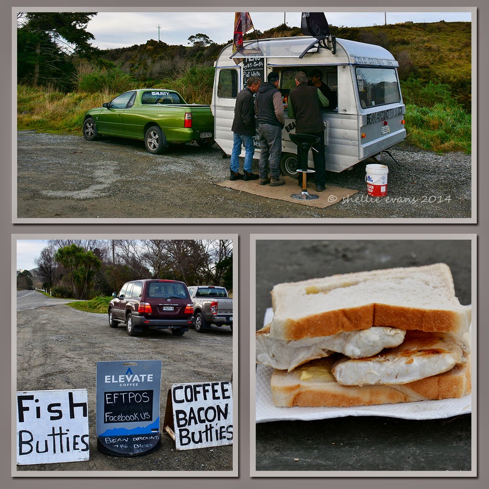
On our way to Karitane we passed this caravan in a layby beside the main highway, selling coffee & fish & bacon butties, it obviously sowed a big seed in David’s head because on our return he pulled in without warning & ordered a fish buttie for lunch (even though it was mid-afternoon & I had lunch with us!)


David was soon joined by two guys who were as impressed with the size of David’s fish buttie as he was. They turned out to be the two surfers we’d seen paddling across the river mouth when we were on the track. David enjoyed his buttie and another “on the road” kiwi experience!


We drove back into Waikouaiti village in search of the large estuary that we’d heard about which was just off the main road and in fact ran along the back of the campground. We found one of the entry walkways near the racetrack and as we pulled over a white heron (kotuku) lifted out of the channel beside the path. Too late for a photo but a great welcome. We could see plenty of ducks; mallards, grey, shovellers & paradise, a large flock of Canada geese, a few domestic geese, white faced herons, shags & pied stilts.


And feeding on the edge of the next pond three Royal Spoonbills (kotuku nutupapa).


Breeding spoonbills have yellow eyebrows and grow distinctive long white crest feathers (plumes) on the back of the head. This male already has his eyebrows.


I watched them for quite some time while they fed in the shallows near where I was standing. Like mine sweepers they all moved in unison sweeping their bill back and forward through the water. When they touched something, I’m assuming a fish or a crab, they rapidly chased it through the water before throwing their bill up in the air releasing the fish before catching it at the bcak of the bill and swallowing it fast.You can see a tiny fish in these two shots.


I was reluctant to move on but we had one more place to visit and the afternoon was drawing to a close. Further on from the estuary and towards the beach was another historic site. We drove to the end of the bay and continued on up a farm drive that ended near the historic Matanaka homestead.

The homestead itself is a private family home but we follow the well marked track for a few hundred metres through a stand of gum trees beside the public car park and a surprise awaits us. At the end of the track across a paddock with the ocean as a backdrop are a collection of stunning farm buildings.


These buildings belong to Otago's first farm which was established here at Matanaka in 1840 by Australian whaler Johnny Jones who had bought the land and an adjoining whaling station in 1838. There is a stable, a granary, a school house, a privy and a farm shed still standing today, all in their original positions. These are probably the oldest surviving farm buildings in NZ and are cared for by the historic places trust, they are rated Category I heritage structures.

The Shed
The buildings make great photography subjects but the nearby gum trees cast long shadows in the setting sun.

The Stables & Shed
Inside the granary is an old whaling boat and in the stables are old tack & saddles including a side saddle. The privy (top left, in the photo below, beside the granary) still had the boxed toilet with lift up lids (nailed down for obvious reasons), in fact it was one large box with three lids. Hmm.....imagine that " 'morning" " 'morning".....


Waikouaiti is turning out to be a great place to stop for the weekend. We realise that had we not had the issue with the van we would have passed through here not giving it a second thought.