Showing posts with label campground. Show all posts

Thursday, May 19

Boulders, Beaches & Big Trees- Northland's West Coast; Part 2

Continuing on from Part 1

Rangi Point Sand Dunes & entrance to the Hokianga Harbour
Two well known tourist destinations, Opononi & Omapere villages are on SH12  near the entrance to the Hokianga Harbour, both have beautiful sand beaches that can be accessed from the road side. 


Across the harbour at North Head, huge golden sand dunes dominate the landscape. Sandboarding  the dunes is a popular activity,  charter boats can supply boards and take you across to the dunes from the Opononi Wharf. 


Opononi became world famous in the mid-1950s when a bottle-nosed dolphin named Opo made friends with the locals and stayed in the harbour until her untimely death several months later. 


Thousands of New Zealanders flocked to see her, some driving  hundreds of kilometres over gravel winding roads to say hello, swim & play with her.  A bronze copy of the original commemorative statue of Opo straddled by a young boy stands in the main street & it’s still popular to have your photo taken alongside her. The original stone statue is now in a local museum.  

On our way south we stop at a Pakia Lookout to say goodbye to the Hokianga Harbour and head on down the coast, coastal views are now replaced with the magnificent kauri trees of the Waipoua Forest. 

Pakia Hill Lookout
The drive through the forest is an experience in itself. The towering forest canopy closes in overhead forming dark green tunnels and huge ancient kauris have formed natural gateways where vehicles must slow to pass through. 

The road edges are fringed with emerald green mosses & luxuriant ferns fronds, it’s cool and damp inside the forest and the outside temperature takes a dive.  

Waipoua Forest is the largest remaining tract of native forest in Northland and it’s also the home of Tane Mahuta, the country's largest kauri tree, which is approximately 2,000 years old and still growing. A short five minute walk through the cooling shade of the forest leads you to the awe-inspiring sight of the majestic Tane Mahuta. 

Love my wide angle lens; makes me appear very tall!
It’s hard to comprehend how big he is until you stand beneath him; it’s nearly 18 metres to the first branch, 51 metres to the top and with a 4.4 metres diameter, it’s clear to see why Tane Mahuta is called 'The Lord of the Forest'.  A  boardwalk & surrounding wooden fence protect the tree from disturbance, kauri have sensitive surface roots that can easily be damaged. 

To get a full view of Tane Mahuta, you can move further along the track, which then leads to another viewing platform. I had my wide angle lens so was able to capture most of Tane Mahuta from directly beneath him.

Taken from the 2nd platform, further away
A boot wash at the track entrance is to protect Tane Mahuta & his fellow brothers & sisters from kauri dieback which has already killed many of the large kauri in the forest. 

The Waipoua Campground (#423) is a great place to base yourself if you’re wanting to explore the local area & forest. 

It’s a basic campground set in amongst the bush beside a river, the bird life is prolific and kiwi can be heard calling at night.

Waipoua River
Further south and just 35 minutes from Dargaville are the Kai Iwi Lakes, a sparkling turquoise jewel in the crown of Northland’s natural attractions. 

Lake Taharoa, Kai Iwi Lakes
Kai Iwi Lakes, there are three, are white sand freshwater dune lakes created over 1.8 million years ago when they were formed by the accumulation of rainwater in depressions of sand. 

Promenade Point Campground, Kai Iwi Lakes
Underlying ironstone prevents the water from leaking away. The lakes have no known natural inlets or outlets, their main source of water is rain, and with a sand base the water is crystal clear. 

Lake Taharoa is the largest of lakes, it’s fringed by pure white sand and when the sun is shining the lake is a vivid blue & looks to have been dropped into place from a faraway tropical island. All that is missing are the waving palm fronds.

There are two camping areas at Lake Taharoa and they are both looked after by the Kaipara District Council; Pine Beach Campground (#430) at one end is the busier camp, it has powered & non-powered sites, toilets, showers and a playground and it’s also more exposed to the hot summer sun. 

The stunning white sand beach is popular with day trippers, many come with their boats & assorted  water toys.


The pine trees that give the camp its name have now gone and natural vegetation is slowly filling in the gaps.

Sunrise with silhouetted dead old man pines behind Pine Beach camp
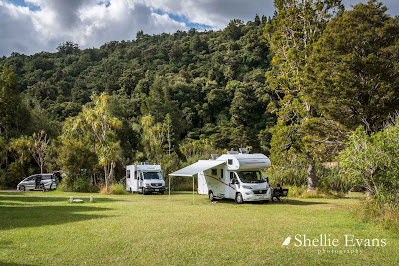
Promenade Point Campground (#427) at the other end of the lake is a more relaxed camping experience with large grassed areas and sites in amongst the lake side bush. 


It's where we spent several gloriously hot late summer days, and had the place to ourselves once the Waitangi Weekend crowds left.

There are shallow areas ideal for swimming at both camps and along the edges of the lake off the Taharoa Domain Road between the camps; you can also fish for rainbow trout or paddle a kayak. Hiking & biking tracks also circle the lakes.


I climbed the hill behind our camp ground to capture the sunset. The photo below is looking back over Lake Taharoa with our camp on the finger of land below the track & the Pines camp at the far end of the lake.


The view from the top of the hill looks out over farmland to the Tasman Sea beyond and a typically stunning west coast sunset.


To be continued...

Monday, October 15

Auckland Regional Parks & More- Part 2

Continuing on from Part 1

After lunch at Opahi Bay on the Mahurangi West side of the harbour, we drove back to Warkworth, back down Sandspit Road, past our turnoff, past Snells Beach and on along Mahurangi East Road. Then it was along Ridge Road twisting and turning through some magnificent homes with magnificent views  until we finally arrived at Scotts Landing on the tip of a narrow finger of land, one of two fingers that make up the Mahurangi East Regional Park.

We were just in time to see one of  Bio Marine's barges arrive at the slip to offload. 


They have several oyster farms in the Mahurangi Harbour; you can see one (centre) in this photo I took from the other side of the harbour (click to enlarge). You can also see Scotts Landing at water level, on the right, on the other side of the water, 35kms by road away.


These are Pacific Oysters and they are farmed in the inter-tidal zone of sheltered harbours and estuaries. Two tides a day wash over the racks that hold the caged oysters. When they are ready to be harvested, the baskets are removed and taken back to the factory to be emptied, then they're cleaned and returned with hatchery spat inside them. Wild spat are collected on timber sticks in the summer months and the sticks are then attached to racks in the inter-tidal zone too.


While David watched the unloading, I walked around the corner and along a short boardwalk to have a look at another magnificent historic homestead in a regional park.


This is Scott Homestead (hence Scott Point) which was once the hub of the area. Mahurangi Harbour had a busy past with timber milling, ship building and firewood cutting trades. 


How's this for a view from your front garden? 


Thomas Scott Jr built the Georgian style house in 1877 on the site where his father, a shipbuilder, ran an inn until it was destroyed by fire. 


I just loved the colour of the clivias under the pohutukawas in the front garden. Being protected from the sun, they were a deep orange.


From Scotts Landing we headed back towards home but not before I twisted David's arm to drive down to Martins Bay to check out the beach and the holiday park.


Martins Bay was another lovely east facing beach with a backdrop of huge pohutukawas; come summer and New Zealand's very own Christmas trees would be in full bloom, what a beautiful sight that would be.


The large camping ground just about filled the bay with hundreds of sites, it's great to see that the casual camping sites are located on the water front (bottom right).  


There are rows and rows of  permanent caravans, all tucked up for winter. This is obviously a very popular place in the summer. No doubt a few of them will be getting a good airing this coming long weekend.


And then there was some more arm twisting to convince David to drive along the waterfront at Snells Beach to check out the two freedom camping sites; he was getting weary and thinking of home.

This is  Snells Beach East where there's a 2 night maximum stay, it looks great but we'd only fit in at the far end otherwise we'd stick out too much for people to pass.


The Snells Beach West site looks to be the better one if we ever come back this way, it also looks like it may be a little quieter (allocated sites at the back of the carpark) with the added bonus of a boat ramp. This also has a two night maximum stay. 


We had the next day off and then the following day (and our final at Sandspit) we headed north to check out the last of the regional parks in the area; Tawharanui which is located at the end of the Takatu Peninsula just south of Omaha Beach.

We were travelling along a winding country road not too far from the end of the road when David suddenly exclaimed 'That's it!" as he pulled to a sudden stop. He had spotted his brother's old business 'Sandpiper Lodge', we hadn't seen it in over 25 years and we weren't exactly sure we'd recognise it or in fact if we were on the right road. We just knew it was in the general area. 

It's still a lodge but with a different name. I remember the estuary that the grounds border, we did some bird watching along the edge and we spotted out first and only Kookaburra, a fairly rare Aussie import that hasn't spread much further than the North Auckland area.


Finally after another short length of narrow and winding road we came over the top of a brow and there below us was Tawharanui Regional Park, another park, like Shakespear, that is protected by a predator proof fence.


There's not many (if any) places in New Zealand that you'd see this sign cautioning drivers to the existence of three rare birds; Pateke (Brown Teal ducks), Takahe (a little like an oversized pukeko and very rare, they were thought to be extinct not too many years ago) and Kiwi. Unfortunately we didn't see any of them; not that we went looking any further than out the car window! According to the DOC Ranger we spoke to, the Takahe are frequent visitors to the surrounding paddocks.


The park has several beaches and a lagoon along with a fairly large campground tucked in behind sand dunes; this camp is another one that has a 8 metre size restriction- I'm guessing because of the narrow road in and sharp drop down to the park. A marine reserve also borders the northern boundary of the park.


There are several walks over the headlands, around the lagoon and along the beaches. We walked along the boardwalk around the end of the lagoon until we reached this noisy fellow, a male Paradise Duck/Putangitangi (can he read?). Paradise Shelducks like to rest on high spots, some even high up in trees. It's likely he was warning his mate that we were approaching, she would have a nest somewhere near by in the reeds of the lagoon.


And that was that, a little bit of the North Auckland area explored. Though not nearly in enough detail but at least we managed to tiki-tour a few places. Onwards and upwards....


Sunday, May 13

Moreporks & Horses- East Cape; Part 1

Catch-up

We left Waipiro Bay and rather than back-track to Te Puia Springs we took the loop road back to the main road. It was only about 8kms but it was narrow, potholed and dusty. David very nearly turned around after 2-3kms but I convinced him we only had a short distance to cover before we were back on the highway.

We called into Ruatoria for lunch and supplies and then continued on, stopping in Tikitiki to take photos of another beautiful historic church. St Mary's Anglican Church is well known due to the beautiful Maori carvings and panelling inside but unfortunately the church has been closed to the public for many years so I'm unable to show you the interior. 


St Mary’s was completed in 1926 as a memorial to the local Ngati Porou soldiers who fought and died in the First World War. Standing high on the hill behind the church is the cenotaph.


There are Te Araroa signs all the way up the coast so I had to post at least one on here. Those that have been following my blog for awhile will know that I've posted many Te Araroa signs from the South Island's remote and sometimes snowed in interior in the past.  Of course those signs are for Te Araroa, New Zealand's Trail or the Long Pathway- the roughly 3000km walking trail from the top of the North Island to the bottom of the South.

This sign post is for the real McCoy- Te Araroa, the East Coast village. It's a pity that the trail doesn't pass through here, it would add a whole lot of money to the local economy but also a whole heap of kilometres to the trail.


Tikitiki is another tiny East Coast settlement with just a few houses and a number of long empty commercial buildings. It says a lot for the area that the only businesses that look to have survived are the RSA (with post boxes) and a barber's shop! Although that looks to have shut down too.  


Our next stop is at Moreports Nest in Te Araroa. This will be our home base for the next few days. We've finally reached the top of the East Coast and the most eastern settlement in New Zealand.


Moreporks Nest is a hidden gem and well worth an extended stay. They offer backpacker accommodation inside the homestead, tent sites on the front lawn and a large parking area at the entrance for self-contained RVs at $15 a night per van. And it lives up to its name; Moreporks gently  (or otherwise) 'more...pork' you to sleep from the pines up behind the campsite every night.

The 130 year old colonial home was originally situated in Gisborne, where it was once occupied by nuns and operated as a school. It was shifted to Te Araroa in 1985 and is slowly being restored to its former glory. A section of the top storey was removed when it arrived and is now one of the whanau's homes down the road.


There's a great communal kitchen and BBQ area at the back of the main house and laundry, toilets & showers available too. It's also one of the very few places around the coast where you can fill up with water; and lovely spring water at that. Most people are on tank supply and water is a valuable commodity for the locals. 


I do feel very sad for Moreporks Nest though, they are about to loose a fair bit of their trade. This is not good for any East Coast business where it is a daily struggle to survive. And the reason? There is a new NZMCA Park about to open just half a kilometre down the road, the digger was parked up ready to attack the paddock a few days after we left.

Te Araroa village is not very big and I know that having the NZMCA Park in town is going to bring a lot of other business to the settlement but sadly it's also going to take some away from Moreporks Nest. I hope people will still support Moreporks, it's a lovely place with charming hosts.

Site of the new Te Araroa NZMCA Park
Of course our first day of exploring was out to East Cape and the lighthouse. We first visited the lighthouse back in 2011 when we did a quick three day loop in our car from Tauranga up the Eastern Bay of Plenty, round the Cape and down to Gisborne, then back home through the Waioeka Gorge. David recalls the number of steps involved and is reluctant to commit to climbing them again. He comes along for the ride anyway, all 22kms and much of it gravel.


It's a beautiful sunny, calm autumn day but you can see from the hillside how ferocious the wind blows out here along the Cape road. The last time I saw bush sculptured like this was in South Westland on the West Coast near Haast. 


I get excited when, just as the road leaves the coast for a short distance to cross a river, I think I spy some horses on the beach. We turn around and head back and sure enough, there are horses resting on the sand near the water line. Two of them are cooling off by actually laying on the wet sand, did you spot them? 


The East Coast is well known for it's free-running horses, they're not actually wild horses although some appear to be wild by nature. They belong to local families and have either broken free from their paddocks (where fencing is not the best) or have been set free to roam at will and caught again when they're needed for breeding or riding. 

I took this photo a couple of days later when I headed back to the beach to see if I could find the horses again. This time there were a few extras in the group.


This photo was also taken on that second trip, as you can see the weather was turning but it made for a great moody shot.


About 6kms from the Cape we stopped to check out a very 'rustic' campground with one of the best views in the country.


East Coast Campground is really just a random, half finished building in a paddock with very few facilities. I'm sure the vision was there at the beginning- the Gisborne District mayor even opened it back in 2005- but it seems to have petered out over time. 


Now all it really is, is just a stunning place to park up for a night or two (self contained of course). I love the directions to the honesty box; arrows on the door frame leading in from outside up the edge and over to a slot in the wall!


We're nearly to the end of the road and ahead of us I can see East/Whangaokeno Island which sits just 2kms off  the Cape. The lighthouse and keepers house used to be on this island (a very lonely place for a family) but was shifted back to the mainland in 1922 because of access problems, earthquakes and landslips.


Around the next corner we can see the lighthouse high atop Otiki Hill, the sign ahead warns of cattle, perhaps that should have been horses.


Though these horses are all behind the flimsy fences that hold them all in the one large paddock...


...that contains all the old lighthouse keepers buildings.


There are horses galore of all different ages from new born foals, yearlings and mares (many seeming to be in foal too). 


A couple of the mares had two youngsters of different ages following along. I counted over 48 horses in total! They all seem to have come from a similar bloodline; a paddock full of chestnuts, palominos, creams and champagne horses. I didn't see a stallion amongst them although there must be one very near! I didn't look too hard though. 

I spoke to one of our hosts back at Moreporks later, asking her what happens to all the horses on the Coast. She told me that East Coast horses are actually highly sort after when they have horse sales because they breed them tough and they have a lot of stamina. I'd have to agree with that!


I could have stayed and watched the horses for ages, especially this little cutie; she kept close as Mum gently rocked back and forward near a pole. It wasn't until Mum stepped away that I realised she'd been scratching her bum on a broken clothes line pole! Don't you dig the foal's little punk-rocker mane tuft.


There was no point in delaying the obvious though, the time had come to tackle those steps, all 800 of them. And surprise, surprise, David decided he might as well climb them too, as I knew he would.


To be continued...