Showing posts with label regional. Show all posts

Sunday, November 4

Living on the Edge

Catch-up 

While we were at Uretiti DOC camp we did a tiki-tour south along the coast stopping at many of the beautiful east coast beaches along the way.

First up was Waipu Cove...


...which was also where I received a few strange looks as I walked slowly around the toilet block photographing the very detailed artwork on the building, which included the history of Waipu and pointed out local attractions including the Hen & Chicken Islands which seemed to be at their closest to coast here at Waipu Cove.


Next up and just over the hill from Waipu Cove was Langs Beach, a small seaside holiday settlement that looks to be filling up fast with permanent houses and larger holiday homes.


We stopped for lunch on the edge of the estuary and harbour at Mangawhai...


...and then drove around to the beautiful surf beach at Mangawhai Heads, the promontory you can see in the centre of the photo above.


It was a beautiful sunny day but with a chilly breeze blowing there weren't too many brave people in swimming. Taranga Island (the Hen) sits on the horizon with tiny Sail Rock silhouetted at the right hand end.


Out in front of the surf club and below the lookout is Sentinel Rock and the breakwater that forms the northern entrance to the Mangawhai Harbour.


I walked along in front of the surf club to a spot where I was able to see across the harbour entrance to the beautiful white sand dunes that form Mangawhai Spit.


At another lookout point near the carpark we were able to watch several boats fight their way home over the swift waters of an out-going tide.


From Mangawhai we drove inland a short distance before heading back towards the coast where there were some magnificent views out over the farmland to Bream Bay.


 Next stop is Te Arai Point and another stunning sparkling white sand surf beach...


...with the added benefit of a camping area. Te Arai Point is the most northerly of the Auckland Regional Parks and camping here is under the same terms & similar conditions to all of their parks. Book and pay and you'll then receive the gate padlock combination to gain access.


There's also the bonus of a dump station beside the park, although it would take a bit of careful manoeuvring to access it during wet weather and, with a bank on one side, bigger rigs may struggle depending on what side their outlet is located.


From the carpark a short track leads walkers to a tiny cove tucked in between two rocky points. This would be an ideal and safe swimming pool on a calm day at high tide.


David walked to one side of the cove...


...while I walked to the other. From my position I was also able to scan the beach to the south. There were several groups of fishermen trying their luck out on the rocky reef.


With one last look at this stunning beach we headed off back up the road and back to the main highway, crossing the Brynderwyns once again and forming a loop back to Uretiti.


We did stop in Kaiwaka so I could photograph St Pauls Church again. This was one of the first churches I photographed when we came north to see the family not long after we hit the road.


I was hoping for a better shot than my previous one; the church is in an awkward spot sitting up on a small plateau, surrounded by houses and with wires crisscrossing the air space around it.


But wait I have more! A very special sighting.

We stopped several times along the coast, checking estuaries and tidal streams for birdlife.  We saw the usual suspects; quite a number of New Zealand Dotterels/Tuturiwhatu in their rusty breasted breeding colours; including this one finding a tasty morsel to snack on.


A few dozen Bar-tailed Godwits/Kuaka, just home from an epic 13,000km journey from their breeding grounds in the Arctic tundra.


'It was a long flight, I'd just like to rest awhile...'
And in amongst the godwits, far out across the mudflats and in the middle of a channel there were three smaller waders. It wasn't until I processed my photos that I identified another long distance flyer and another first sighting to add to our virtual bird list; the Ruddy Turnstone.

This stocky little bird also flies to the Arctic tundra to breed before returning to the Southern Hemisphere in the summer. Most birds stop in Australia with only 1000-3000 continuing on to New Zealand. But, while this was a special sighting, it wasn't the special, SPECIAL sighting.


It was then that we had an OMG 'is it/isn't it, maybe, yes it is' moment. There, not too far ahead of us resting on the mudflats, were two tiny birds.


Two tiny birds living on the edge. These are Fairy Terns/Tara iti and with a population of around 45 individuals and just 12 breeding pairs, these are our most critically endangered endemic bird. Fairy terns are around 250mm long and weigh in at a mere 70gms, hence their name. In 1983 there were only 3-4 breeding pairs and the birds were headed for extinction. There are just 4 breeding sites in the upper North Island and the population has increased slowly with pest control, nest site monitoring and full time volunteer wardens looking out for the birds while they're nesting. 

We are thrilled to be able to say we saw Fairy Terns, and the best bit? We weren't even looking for them.


Nailed! Another one off the virtual list, and a very special little bird at that.


Monday, October 15

Auckland Regional Parks & More- Part 2

Continuing on from Part 1

After lunch at Opahi Bay on the Mahurangi West side of the harbour, we drove back to Warkworth, back down Sandspit Road, past our turnoff, past Snells Beach and on along Mahurangi East Road. Then it was along Ridge Road twisting and turning through some magnificent homes with magnificent views  until we finally arrived at Scotts Landing on the tip of a narrow finger of land, one of two fingers that make up the Mahurangi East Regional Park.

We were just in time to see one of  Bio Marine's barges arrive at the slip to offload. 


They have several oyster farms in the Mahurangi Harbour; you can see one (centre) in this photo I took from the other side of the harbour (click to enlarge). You can also see Scotts Landing at water level, on the right, on the other side of the water, 35kms by road away.


These are Pacific Oysters and they are farmed in the inter-tidal zone of sheltered harbours and estuaries. Two tides a day wash over the racks that hold the caged oysters. When they are ready to be harvested, the baskets are removed and taken back to the factory to be emptied, then they're cleaned and returned with hatchery spat inside them. Wild spat are collected on timber sticks in the summer months and the sticks are then attached to racks in the inter-tidal zone too.


While David watched the unloading, I walked around the corner and along a short boardwalk to have a look at another magnificent historic homestead in a regional park.


This is Scott Homestead (hence Scott Point) which was once the hub of the area. Mahurangi Harbour had a busy past with timber milling, ship building and firewood cutting trades. 


How's this for a view from your front garden? 


Thomas Scott Jr built the Georgian style house in 1877 on the site where his father, a shipbuilder, ran an inn until it was destroyed by fire. 


I just loved the colour of the clivias under the pohutukawas in the front garden. Being protected from the sun, they were a deep orange.


From Scotts Landing we headed back towards home but not before I twisted David's arm to drive down to Martins Bay to check out the beach and the holiday park.


Martins Bay was another lovely east facing beach with a backdrop of huge pohutukawas; come summer and New Zealand's very own Christmas trees would be in full bloom, what a beautiful sight that would be.


The large camping ground just about filled the bay with hundreds of sites, it's great to see that the casual camping sites are located on the water front (bottom right).  


There are rows and rows of  permanent caravans, all tucked up for winter. This is obviously a very popular place in the summer. No doubt a few of them will be getting a good airing this coming long weekend.


And then there was some more arm twisting to convince David to drive along the waterfront at Snells Beach to check out the two freedom camping sites; he was getting weary and thinking of home.

This is  Snells Beach East where there's a 2 night maximum stay, it looks great but we'd only fit in at the far end otherwise we'd stick out too much for people to pass.


The Snells Beach West site looks to be the better one if we ever come back this way, it also looks like it may be a little quieter (allocated sites at the back of the carpark) with the added bonus of a boat ramp. This also has a two night maximum stay. 


We had the next day off and then the following day (and our final at Sandspit) we headed north to check out the last of the regional parks in the area; Tawharanui which is located at the end of the Takatu Peninsula just south of Omaha Beach.

We were travelling along a winding country road not too far from the end of the road when David suddenly exclaimed 'That's it!" as he pulled to a sudden stop. He had spotted his brother's old business 'Sandpiper Lodge', we hadn't seen it in over 25 years and we weren't exactly sure we'd recognise it or in fact if we were on the right road. We just knew it was in the general area. 

It's still a lodge but with a different name. I remember the estuary that the grounds border, we did some bird watching along the edge and we spotted out first and only Kookaburra, a fairly rare Aussie import that hasn't spread much further than the North Auckland area.


Finally after another short length of narrow and winding road we came over the top of a brow and there below us was Tawharanui Regional Park, another park, like Shakespear, that is protected by a predator proof fence.


There's not many (if any) places in New Zealand that you'd see this sign cautioning drivers to the existence of three rare birds; Pateke (Brown Teal ducks), Takahe (a little like an oversized pukeko and very rare, they were thought to be extinct not too many years ago) and Kiwi. Unfortunately we didn't see any of them; not that we went looking any further than out the car window! According to the DOC Ranger we spoke to, the Takahe are frequent visitors to the surrounding paddocks.


The park has several beaches and a lagoon along with a fairly large campground tucked in behind sand dunes; this camp is another one that has a 8 metre size restriction- I'm guessing because of the narrow road in and sharp drop down to the park. A marine reserve also borders the northern boundary of the park.


There are several walks over the headlands, around the lagoon and along the beaches. We walked along the boardwalk around the end of the lagoon until we reached this noisy fellow, a male Paradise Duck/Putangitangi (can he read?). Paradise Shelducks like to rest on high spots, some even high up in trees. It's likely he was warning his mate that we were approaching, she would have a nest somewhere near by in the reeds of the lagoon.


And that was that, a little bit of the North Auckland area explored. Though not nearly in enough detail but at least we managed to tiki-tour a few places. Onwards and upwards....


Friday, October 12

Auckland Regional Parks & More- Part 1

Real-time

From our base at Sandspit we explored some of the Regional Parks that we couldn't visit with the rig on the back. Some of the camping grounds were closed due to ground conditions, others closed for winter and a couple had a size restriction.

Couldrey House- Wenderholm
Our first stop was back down SH1 at Wenderholm Regional Park which is just north of Waiwera off the Hibiscus Coast Highway. Many people will be familiar with Wenderholm, it's a peaceful oasis for a rest or lunch stop as you're heading in and out of Auckland. Although it's probably not so busy now that Northern Gateway Toll Road has by-passed the Park. 

There are many huge pohutukawas in the reserve and quite a number of historic trees, some were gifts to the owner from Sir George Grey (Governor of New Zealand) and planted as early as the 1860s.


Wenderholm opened in 1965 and was the first Auckland Regional Park. The Park is also a lovely place to have a picnic or BBQ, walk one of the many tracks or to camp, either at the the CSC overnight site (bottom right) or the new Schischka campground (which was closed). The public toilet block (below left) has to be one of the flashest I've seen in a park (don't forget to click on the photos to view enlarged)


Auckland politician Robert Graham was the first European owner in 1868 and built his homestead Wenderholm (winter home) here so that he had somewhere to stay while he spent time at his Waiwera thermal resort in winter. The house is now known as Couldrey House after the last private owner.


From Wenderholm we headed back up the road a few kms and onto the Mahurangi West Road which winds it's way along a ridge out to the coast. The Puhoi River separates Mahurangi West from Wenderholm. This is looking north east over the Mahurangi Harbour, much of the land across the water is the Mahurangi East/Snells Beach peninsula.


At the end of the road we drop down into Sullivans Bay (Otarawao Bay) part of the Mahurangi Regional Park. The park is divided into three fingers; Mahurangi West, Scott Point and Mahurangi East (which is only accessible by sea due to it being landlocked). The Park straddles the large and sheltered Mahurangi Harbour.


Maori lived here in large communities and there are several fortified  pa sites on strategic points around the reserve. A sea captain, John Sullivan, married a local Maori woman and settled at Sullivans Bay in the 1870s. Their descendants farmed the land for nearly a century and farming continues today. 

There is also a small campground in the bay for tenting and RVs under 8 metres (two photos, bottom left). We have a debate between ourselves quite regularly; is the 8 meters the length of your rig or the length of your van without tow or towed vehicles? I'll leave that for your conscience to decide. The road in is narrow and there are a few blind corners but nothing we wouldn't drive cautiously.


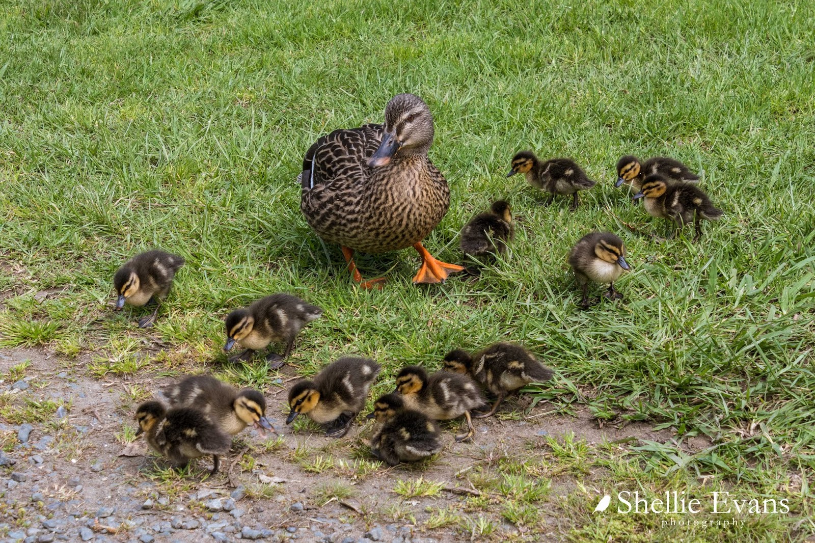
As we drove into the car park we spotted ahead of us, lots of  little black dots resting on the tarseal, spread from one side of the road to the other. At first I thought they were sun-baking sparrows and they'd fly off as we approached but no, they stayed put.

The 'sparrows' turned out to be THIRTEEN tiny ducklings. Their mother was frantically trying to herd them off the road when she saw us coming. It was lucky we slowed down for them, it would have been a disaster had another vehicle driven through unaware- squished ducklings everywhere!  I managed to take a photo of them all before they spread out again, once they were on the move they were darting here, there and everywhere. I have a feeling (from past experiences) thirteen ducklings would have soon become ten, then seven, then....


From Sullivans Bay, we headed back to the top, along the road a little....

Mahurangi East
...and then down into tiny secluded Opahi Bay which is just around the corner from Sullivans. We had lunch on the foreshore, surrounded by baches and holiday homes, many of them hanging off the steep sides of the gully.


I loved the dinghy rack beside the reserve; tenders for the dozens of yachts at moorings further around the point.


There was an old urupa (Maori cemetery) at the end of the bay, Ophai Bay has one of the pa sites mentioned earlier and much of the waterfront is Maori Owned.

We see so many old caravans on our travels, but this 'Super Freight' slide on is a new one on me. It looks like these are now play rooms for the grandkids perhaps.


At the other end of the bay, tucked in under the overhanging bush, and not likely to have seen the sun in years, is a small collection of caravans that have seen better days.


I guess families have holidayed here in summers past but going by the sorry state of them now, they'd need a lot of work to get them even slightly habitable. Pitching a tent would probably be a better option! 


To be continued....Part 2