Real-time
From our base at Sandspit we explored some of the Regional Parks that we couldn't visit with the rig on the back. Some of the camping grounds were closed due to ground conditions, others closed for winter and a couple had a size restriction.
 |
| Couldrey House- Wenderholm |
Our first stop was back down SH1 at Wenderholm Regional Park which is just north of Waiwera off the Hibiscus Coast Highway. Many people will be familiar with Wenderholm, it's a peaceful oasis for a rest or lunch stop as you're heading in and out of Auckland. Although it's probably not so busy now that Northern Gateway Toll Road has by-passed the Park.
There are many huge pohutukawas in the reserve and quite a number of historic trees, some were gifts to the owner from Sir George Grey (Governor of New Zealand) and planted as early as the 1860s.

Wenderholm opened in 1965 and was the first Auckland Regional Park. The Park is also a lovely place to have a picnic or BBQ, walk one of the many tracks or to camp, either at the the CSC overnight site (bottom right) or the new Schischka campground (which was closed). The public toilet block (below left) has to be one of the flashest I've seen in a park (don't forget to click on the photos to view enlarged)

Auckland politician Robert Graham was the first European owner in 1868 and built his homestead Wenderholm (winter home) here so that he had somewhere to stay while he spent time at his Waiwera thermal resort in winter. The house is now known as Couldrey House after the last private owner.


At the end of the road we drop down into Sullivans Bay (Otarawao Bay) part of the Mahurangi Regional Park. The park is divided into three fingers; Mahurangi West, Scott Point and Mahurangi East (which is only accessible by sea due to it being landlocked). The Park straddles the large and sheltered Mahurangi Harbour.

Maori lived here in large communities and there are several fortified pa sites on strategic points around the reserve. A sea captain, John Sullivan, married a local Maori woman and settled at Sullivans Bay in the 1870s. Their descendants farmed the land for nearly a century and farming continues today.
There is also a small campground in the bay for tenting and RVs under 8 metres (two photos, bottom left). We have a debate between ourselves quite regularly; is the 8 meters the length of your rig or the length of your van without tow or towed vehicles? I'll leave that for your conscience to decide. The road in is narrow and there are a few blind corners but nothing we wouldn't drive cautiously.

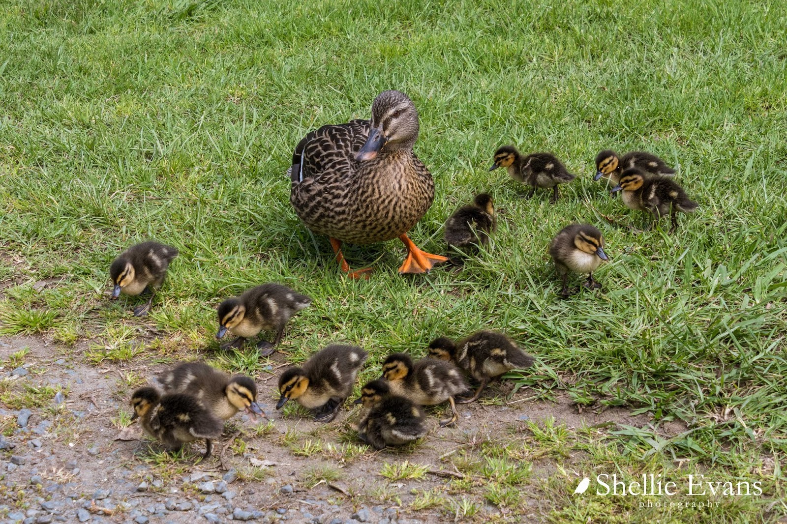
As we drove into the car park we spotted ahead of us, lots of little black dots resting on the tarseal, spread from one side of the road to the other. At first I thought they were sun-baking sparrows and they'd fly off as we approached but no, they stayed put.
The 'sparrows' turned out to be THIRTEEN tiny ducklings. Their mother was frantically trying to herd them off the road when she saw us coming. It was lucky we slowed down for them, it would have been a disaster had another vehicle driven through unaware- squished ducklings everywhere! I managed to take a photo of them all before they spread out again, once they were on the move they were darting here, there and everywhere. I have a feeling (from past experiences) thirteen ducklings would have soon become ten, then seven, then....
From Sullivans Bay, we headed back to the top, along the road a little....
 |
| Mahurangi East |

I loved the dinghy rack beside the reserve; tenders for the dozens of yachts at moorings further around the point.

There was an old urupa (Maori cemetery) at the end of the bay, Ophai Bay has one of the pa sites mentioned earlier and much of the waterfront is Maori Owned.
We see so many old caravans on our travels, but this 'Super Freight' slide on is a new one on me. It looks like these are now play rooms for the grandkids perhaps.

At the other end of the bay, tucked in under the overhanging bush, and not likely to have seen the sun in years, is a small collection of caravans that have seen better days.

I guess families have holidayed here in summers past but going by the sorry state of them now, they'd need a lot of work to get them even slightly habitable. Pitching a tent would probably be a better option!

To be continued....Part 2
No comments:
Post a Comment
Thank you for taking the time to leave a message, I love reading them! All comments are personally moderated by me and I will post and answer them as soon as possible, Shellie