Showing posts with label old. Show all posts

Friday, October 12

Auckland Regional Parks & More- Part 1

Real-time

From our base at Sandspit we explored some of the Regional Parks that we couldn't visit with the rig on the back. Some of the camping grounds were closed due to ground conditions, others closed for winter and a couple had a size restriction.

Couldrey House- Wenderholm
Our first stop was back down SH1 at Wenderholm Regional Park which is just north of Waiwera off the Hibiscus Coast Highway. Many people will be familiar with Wenderholm, it's a peaceful oasis for a rest or lunch stop as you're heading in and out of Auckland. Although it's probably not so busy now that Northern Gateway Toll Road has by-passed the Park. 

There are many huge pohutukawas in the reserve and quite a number of historic trees, some were gifts to the owner from Sir George Grey (Governor of New Zealand) and planted as early as the 1860s.


Wenderholm opened in 1965 and was the first Auckland Regional Park. The Park is also a lovely place to have a picnic or BBQ, walk one of the many tracks or to camp, either at the the CSC overnight site (bottom right) or the new Schischka campground (which was closed). The public toilet block (below left) has to be one of the flashest I've seen in a park (don't forget to click on the photos to view enlarged)


Auckland politician Robert Graham was the first European owner in 1868 and built his homestead Wenderholm (winter home) here so that he had somewhere to stay while he spent time at his Waiwera thermal resort in winter. The house is now known as Couldrey House after the last private owner.


From Wenderholm we headed back up the road a few kms and onto the Mahurangi West Road which winds it's way along a ridge out to the coast. The Puhoi River separates Mahurangi West from Wenderholm. This is looking north east over the Mahurangi Harbour, much of the land across the water is the Mahurangi East/Snells Beach peninsula.


At the end of the road we drop down into Sullivans Bay (Otarawao Bay) part of the Mahurangi Regional Park. The park is divided into three fingers; Mahurangi West, Scott Point and Mahurangi East (which is only accessible by sea due to it being landlocked). The Park straddles the large and sheltered Mahurangi Harbour.


Maori lived here in large communities and there are several fortified  pa sites on strategic points around the reserve. A sea captain, John Sullivan, married a local Maori woman and settled at Sullivans Bay in the 1870s. Their descendants farmed the land for nearly a century and farming continues today. 

There is also a small campground in the bay for tenting and RVs under 8 metres (two photos, bottom left). We have a debate between ourselves quite regularly; is the 8 meters the length of your rig or the length of your van without tow or towed vehicles? I'll leave that for your conscience to decide. The road in is narrow and there are a few blind corners but nothing we wouldn't drive cautiously.


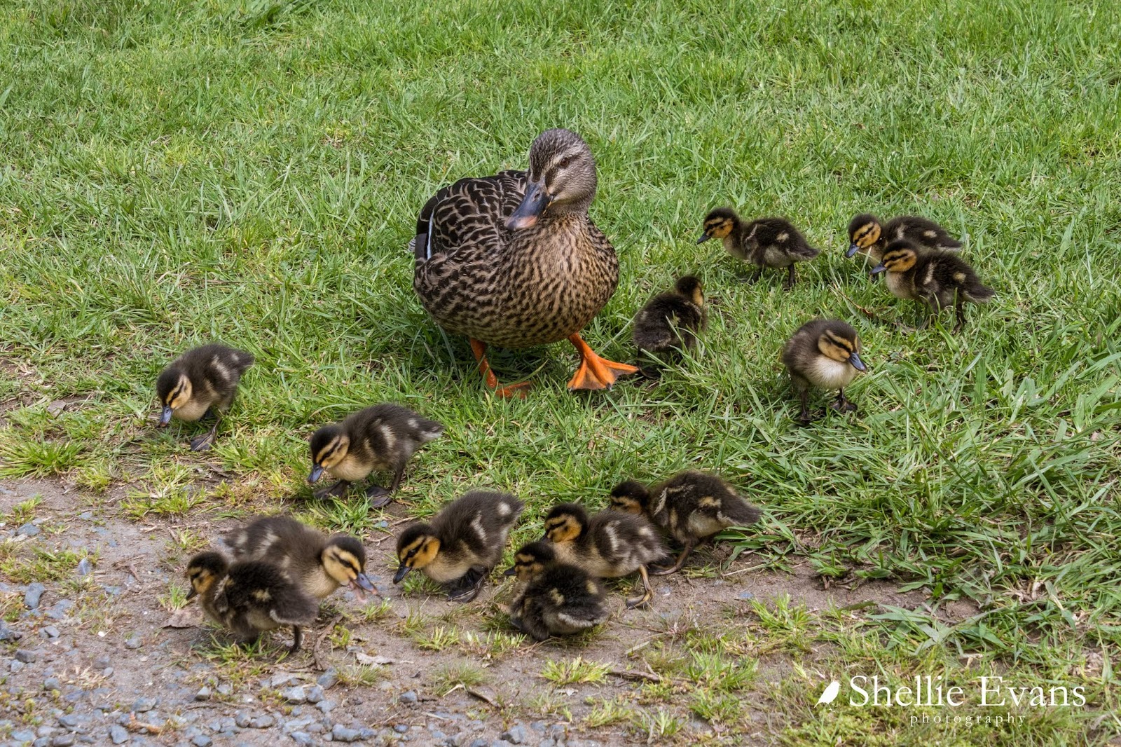
As we drove into the car park we spotted ahead of us, lots of  little black dots resting on the tarseal, spread from one side of the road to the other. At first I thought they were sun-baking sparrows and they'd fly off as we approached but no, they stayed put.

The 'sparrows' turned out to be THIRTEEN tiny ducklings. Their mother was frantically trying to herd them off the road when she saw us coming. It was lucky we slowed down for them, it would have been a disaster had another vehicle driven through unaware- squished ducklings everywhere!  I managed to take a photo of them all before they spread out again, once they were on the move they were darting here, there and everywhere. I have a feeling (from past experiences) thirteen ducklings would have soon become ten, then seven, then....

From Sullivans Bay, we headed back to the top, along the road a little....

Mahurangi East
...and then down into tiny secluded Opahi Bay which is just around the corner from Sullivans. We had lunch on the foreshore, surrounded by baches and holiday homes, many of them hanging off the steep sides of the gully.


I loved the dinghy rack beside the reserve; tenders for the dozens of yachts at moorings further around the point.


There was an old urupa (Maori cemetery) at the end of the bay, Ophai Bay has one of the pa sites mentioned earlier and much of the waterfront is Maori Owned.

We see so many old caravans on our travels, but this 'Super Freight' slide on is a new one on me. It looks like these are now play rooms for the grandkids perhaps.


At the other end of the bay, tucked in under the overhanging bush, and not likely to have seen the sun in years, is a small collection of caravans that have seen better days.


I guess families have holidayed here in summers past but going by the sorry state of them now, they'd need a lot of work to get them even slightly habitable. Pitching a tent would probably be a better option! 


To be continued....Part 2


Sunday, September 7

Farewell to Old Wharves

On the way home from the Archway Islands we stopped to do the short 5 minute walk to Cape Farewell; the carpark was the end of a road we had passed earlier in the day and still part of Puponga Farm Park.

Cape Farewell is the most northerly point on the South Island and is located just west of Farewell Spit. It was named by Captain James Cook in 1770 - it was the last land seen by his crew as they departed on their homeward voyage.


The sun would now be perfect to shoot the Archway Islands but it’s totally in the wrong position for the Cape (hence the sun spots on my lens). I just can’t win! Morning, with the sun rising would be perfect here! I know that the Farewell Spit tour stops here on the way to the Spit & I’m hoping that when we do the tour I’ll be able to get some better shots.


It’s fascinating seeing all the coloured rock layers in the cliffs that surround the Cape. There are a number of faultlines running through the area & I wonder how long the arch will last; a few dozen years or hundreds of years or perhaps thousands? Although it’s a wonder it is still standing, what with the wave action and earthquakes.


While standing on the platform looking over the edge we could hear seal pup cries from far below. It took a few moments to find them, frolicking about in the water and resting on rocks. One pup was having fun all by himself surfing in on the waves; he’d surf in, swim back out under the waves and surf back in again.

We walked up the hill a short way and looked over the edge of the cliffs as far as we dared. If we brought the grandkids here, they’d be tied to our sides!  “ Hey look Nana, I can do roly-polys down the hill!” Oops. Plop!


The walk up to Pillar Point Lighthouse looked far too strenuous, I think I can safely say we won’t be saving that for another time!


And with that, we can now say we have visited both the most northerly & most southerly points of the South Island. This is Slope Point at the south end of the Catlins which we visited back in January.


And now for a few random shots from the road trip;

Near the Cape carpark,  the iconic New Zealand Cabbage tree (alive this time).


This friendly peacock greeted us at both ends of the Archway Island walk. He was looking for hand-outs, poking his head inside the car door as soon as I opened it and following me around when he saw I was eating food. It’s hard to believe how magnificent the colours & patterns are on a peacock, how can nature produce such finery.


You’ll remember the whitebait couple we found beside the tiny stream on our way to the Arches? We had stopped to see this flock of Royal Spoonbills (Kotuku Ngutupapa), numbering 27 (or 28, we couldn't quite decide), this is the largest flock of spoonbills we’ve seen on our travels. They were very obliging and I was able to move in quite close. That was until I slipped off the log I was quietly sidling along on my behind. Then they took flight.


The tide was all the way out by the time we made our way home along the Golden Bay shoreline and the sand flats fully exposed, making for some interesting colours and patterns.


We stopped at Puponga (near the beginning of the curve to Farewell Spit), where I’d seen a sign post indicating there was an old wharf somewhere nearby. With the tide out the piles of the old Puponga Wharf were now exposed. The Puponga Wharf was used early last century by colliers to cart coal away from a number of mines in the area.  Because of the shallow bay the wharf was over half a mile long and was thought to be the longest in the Southern Hemisphere at the time. And even with it being so long, the channel had to be constantly dredged to give access to the 1000 ton ships. Eventually silting in the bay overtook the wharf, the mines closed and the piles from the wharf have slowly rotted away.


While I was taking photos of the wharf piles I could hear a low rumble off in the distance. Far out on the edge of the of the water I could see tiny little specs moving about. David had seen the movement too and was looking through the binoculars. I zoomed in on them to see that there were a couple of jeeps and half a dozen quad bikes towing trailers about. This is a zoomed in shot.


It was then that we realised that they must be harvesting cockles commercially. I’d seen a programme awhile ago on Country Calendar and when I checked it out I found that a company based nearby were collecting "Littleneck Clams" or what we used to call cockles. The harvesting looked pretty intrusive, a scoop collecting the mud, transporting it up a small conveyor belt of sorts, spitting out the cockles into a bin on the back. The quad bikes had a row of trailers on the back with the fast filling bags. This is the zoomed in shot now heavily cropped! And that's part of Farewell Spit in the background on the left.


And finally here are two more old decaying wharves. That shallow Golden Bay has a lot to answer for!

This is the old Collingwood Wharf, it’s located on the ocean side of the town, by the 1930s the wharf was “high & dry” (this is at near high tide). A new wharf was then built on the inside of the town in the estuary but that also silted up fast and by the mid 1940s could no longer be used commercially.


Back towards Takaka is the tiny settlement of Onekaka which was once a major industrial area. During the 1920-30s local iron ore was turned into pig-iron and iron pipes at the Onekaka Ironworks and shipped from Onekaka wharf. Between 1922 and 1935, over 80,000 tons of iron was produced, with up to 180 men being employed. These rusting & rotting piles are all that remains of the wharf built by the Onekaka Iron & Steel Company.


There are other remains of old wharves in the area which I haven’t managed to visit. Yet.


Thursday, June 12

Old Cromwell Town & Lowburn Colours

The construction of the Clyde Dam and filling of Lake Dunstan in the 1980s brought major changes to Cromwell. Two narrow gorges with their wild rivers, many acres of orchards & Cromwell’s original commercial centre were all drowned by the new Lake Dunstan.

The old town centre & historic bridge were not forgotten though, many of the original buildings were deconstructed & rebuilt further up the road to form part of a historic precinct at the end of Melmore Terrace and overlooking the Lake Dunstan. Other buildings already at the high end of the terrace were restored.

Resited- Jolly’s Grain Store- built pre 1880


Resited- London House- (Belfast Store) built 1880

 
I wonder how many children have clambered over Toby & his cart.
 

The Masonic Lodge was built in 1901 & still stands on it’s original site which was once the top end of Melmore Terrace.


Lake Dunstan, the Kawarau River arm, looking towards Bannockburn & the Carrick Range which we crossed over when we drove the Nevis.


Cromwell was once known as “The Junction” being that the Clutha & Kawarau Rivers met here in two deep & rugged gorges. As it turned out, an ideal site for a hydro lake to form behind the Clyde Dam which is many kilometres downstream.

And the historic bridge? A bridge that crossed the Clutha River & one I can’t add to my Clutha River Bridges because it’s 11 metres under water! It’s beneath the clear water in the top right photo below. There is a urban myth that there’s still a Mkl Zephyr parked on it. The new Cromwell Bridge can be seen at the back of the top left photo below.


Most of the buildings in the old town & surrounding area were demolished to make way for the new lake, others like the facade from the old Athenaeum in the bottom right photo were left as they were & filled in with soil. This gives a good indication of how far Melmore Terrace of the old town has been buried, only the top half of the building is exposed. Some of the stone work from the old school also remains (centre photo).

Where once the wild Kawarau River flowed there’s now a calm & beautiful recreation lake with the vineyards of Bannockburn reaching up the dry & rocky hills behind.


Cromwell has many orchards along with the vineyards, these Y shaped apricot trees provided me with some good colour along with plenty of leading lines.


You may remember that we stayed at Lowburn on the shores of Lake Dunstan twice while in the area. The autumn colours were showing on our first visit but by the time we returned three weeks later the yellow of the poplars had intensified to a deep rich gold and looked stunning against the blue skies.

On some mornings the fog rolled in early and then lifted, once the sun came up, to reveal these golden poplars & willows across the other side of the lake.


There was also a row of poplars along the back fence of a paddock over the road from the camp site that always looked fabulous backlit in the late afternoon sun.


And even more stunning from the sunny side. I loved the decreasing height of the trees as they moved up the hill.


Just along the road from the campsite and up a side road is the (new) settlement of Lowburn, you’ll remember from my "Collecting Water” blog that there’s a spring beside the hall that we use, this is the small pond, complete with white ducks, near the hall with “Sugarloaf” behind.


The dam construction affected Lowburn too, much of the original Lowburn flat was inundated by the creation of Lake Dunstan. The church and hall were relocated to this higher site, but the old bridge, the camping ground and the hotel are forever under Lake Dunstan.