Showing posts with label lowburn. Show all posts

Sunday, April 19

Cromwell- Out & About and Beyond

Catch-up (late October 2019)

Before we leave Cromwell I thought I'd share a few photos I took while out exploring.

A choppy Lake Dunstan on a wild and windy day, taken from just through the trees at the NZMCA Lowburn Park.


Looking down the lake towards Cromwell and the Carrick Range.


A storm front passing over the NZMCA Park at Lowburn, Cromwell. A new section of the cycle-way around the lake passes right behind the park.


Happy hour at Lowburn.


The many moods of Lake Dunstan, this time a calm & reflective day on the lake.


Looking across the lake towards Northburn and the Tarras-Cromwell highway.


We were waiting for news from our Winton family which may have meant we'd have to return to Southland. So once we had stayed our six night limit at the Lowburn NZMCA Park we moved down the road a couple of kilometres to the Lowburn Harbour freedom camping area which has also has a limit (3 nights). 

We have always stayed at Lowburn Harbour in the past but since the NZMCA Lowburn Park opened a few months earlier we'd taken to staying there on our visits. They are both great spots, although the freedom camping site can get very busy during the summer season.


The wind protected Lowburn Harbour inlet nearly always provides perfect reflection opportunities....


...with amazing cloud formations up above.


After using up our three night quota at Lowburn Harbour we moved another few kilometers down the lake to the NZMCA Rotary Glen Park which also has a three night limit. 


The calm early spring weather also provided me with some gorgeous photo opportunities of my favourite Cromwell location; the Inlet at Bannockburn. I try to visit The Inlet everytime we stop in Cromwell; the scene never changes, just the seasons. 

Click on the photo to enlarge and then scroll back & forward for a better comparison view.

October 2019
August, 2019
May, 2016
The Bannockburn Bridge over the Kawarau River.

October 2019
May, 2014
The Inlet at Bannockburn

October, 2019
August, 2019
May, 2016
October, 2019
August, 2019


I drove through to Frankton (Queenstown) for a day's shopping, stopping in the Kawarau Gorge along the way. And in fact I wasn't very impressed with the new shopping centre (or just didn't feel like shopping) so I spent most of my time taking photos there & back. 


The Chinese mining huts at the Kawarau Gorge Goldfields Mining Centre (shot across the river from where the above photo was taken).


Historic Roaring Meg Power Station in the Kawarau Gorge.


Kawarau River and bridge not far from the Nevis Bluff.


And in Queenstown, the Lower Shotover River and The Remarkables, taken from the historic Lower Shotover Bridge which was built in 1871 and was the first bridge to cross the Shotover. 


And finally a few photos from Old Cromwell Town which I visited a few days later. 


Thursday, October 31

Reflections & An Aurora in Cromwell

Catch-up

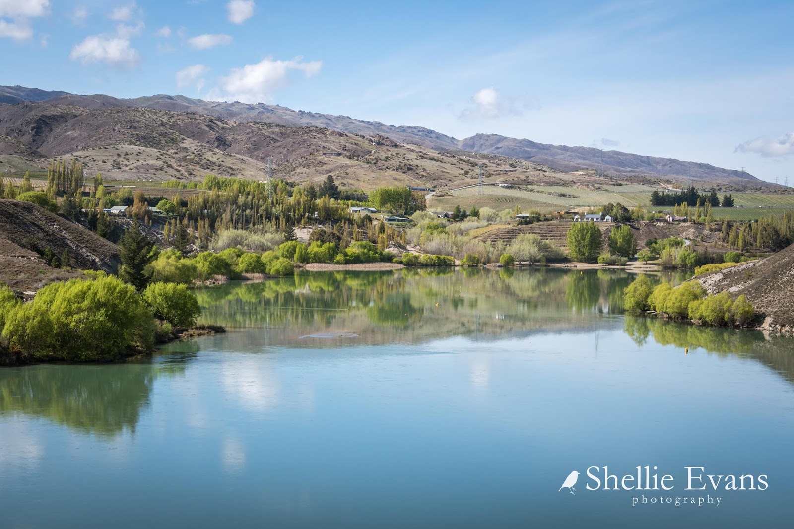
Cromwell has definitely become one of our favourite towns in Central Otago. And when we drive back in and see Lake Dunstan stretched out in front of us, looking spectacular in the winter sunshine, it feels a little like we're arriving home.


Other than a couple of vans visiting for one night, we once again had a NZMCA Park all to ourselves for the length of our stay.  A sure sign that summer is on its way is when the morning sun cleared the pines well before lunch time this visit, and there were a couple more hours of sunshine at the end of the day before it disappeared behind the plateau across the road.


The reflections on Lake Dunstan are amazing in the crisp, clear air of Central Otago. Here are a few more photos taken just through the trees from the park. Most days the lake was a millpond, the sun shone and the air was crisp, cold and still. This is looking down towards Cromwell town with the snow capped Carrick Range behind.


Northburn and the Dunstan Mountains across the lake-


And looking north up the lake towards Bendigo and Tarras-


It became apparent while we were in Ranfurly that my new laptop was even more power hungry than we'd anticipated and our 300watt inverter, which only ran our TV, was not coping very well with the extra work load. 

Fitted to the roof of our front locker, close to the batteries
So David ordered a 2000w inverter online and while we were in Cromwell we called in Ian from Hawk Services to fit it. Ian did an awesome job and we'd highly recommend his company should you need any electrical work done while in Central. It also was so much better that he does 'house calls' so we didn't even have to leave our site.


Ian came with his best buddy Alfred, a Golden Retriever/Standard Poodle cross, who enjoyed checking out all the rabbit holes. Once he tired of that he made himself right at home on our mat while he waited for Dad.


Ian also does Electrical Warrant of Fitnesses so with Alfred patiently waiting in the driving seat, I had a little play with Photoshop- can you see what I did?


Alfred is willing those rabbits to come close.


Late one evening, just after I had climbed into bed, I saw that I had an alert flashing on my phone. An alert to tell me that the Southern Lights were playing. Unfortunately I was late in seeing the message and Lady Aurora had already been dancing for a couple of hours. 

I was all tucked up, warm and snug in bed and thought to myself,  'No, I'll give it a miss tonight'. I lay there for a couple of minutes and then couldn't contain myself any longer. I was up, out of bed and at the door in flash checking outside to see if there was a clear sky. 

With no moon, the dark sky was a 360 degree mass of tiny sparkling stars with the Milky Way directly overhead; a perfect sky to view an aurora. Though I couldn't see any sign of it with my naked eye. Our door faced south so I grabbed my camera and took a couple of hand held shots from the top step, roughly in the direction I thought due south would be. 

Holy cow! I couldn't believe what I saw on the back of the camera, a brilliant green band above Cromwell town. All hell broke loose as I grabbed clothes left, right and centre, all the while trying to change my lens, grab my tripod, extra battery and head torch. I needed to get to the lake edge in front of the trees as fast as I could before the aurora died down.

Checking for the Aurora Australis (hand-held)
There are some benefits of staying in remote &/or deserted camps, it's very handy for night shots as there usually no light pollution from nearby suburbia (although Cromwell was right in the firing line this time) and it's just a matter of stepping outside the door to view a magic sight. Another big plus is that I don't need to worry about anyone seeing me in my weird get-up; fluffy white dressing gown, PJs plus trackies over the top tucked into thick socks pulled high, David's gumboots, fingerless gloves, woolly hat and a head torch! No wonder the rabbits scattered. 

Unfortunately I was in such a hurry to start shooting my first few shots were out of focus. There's a real art in getting your camera and settings fine tuned and focus sharp when it's pitch black. It doesn't help when you also need reading glasses to see the screen but not to see through the viewfinder. I've posted this out of focus shot because it's the one and only shot I have of the 'picket fence', the green single beams you can see above the green band. This was the last I saw of the fence, though the pink beams to the left danced back and forward for awhile longer.


Eventually I managed to get the focus and settings right. This also wasn't helped by the fact that it had been a couple of years since my last aurora photo shoot and it's easy to forget the finer setting details. But then again every aurora is different and so are the settings, it's trial and error for a little while. There are a few tips of shooting an aurora and a link to the Aurora Facebook page in this blog from my last big aurora- Absolutely Amazing Aurora

I entered this photo in the Naseby Night Sky competition a few weeks ago (for night skies over Central Otago) and I was thrilled to hear just the other day that I was placed second! That was a lovely surprise.


As the beams died down I spun my camera around on the tripod to capture a portrait shot of the Milky Way. I might have missed the main aurora show but I was pleased with the few shots I did take. Afterwards I turned everything off and just stood there embraced by the inky black stillness and in awe of the spectacular night sky above.


Once again it was time to move on to our next destination (fingers crossed that maybe one day, the Council's consent for the park will be increased from a maximum 6 night stay to 21 nights, the usual NZMCA Park allowance).


We headed north along Lake Dunstan towards Wanaka and as the upper Clutha Valley opened up, across the farmland my favourite snow covered Hawkdun Range was in clear view. Hard to believe we we were driving along it's base just a couple of weeks earlier.


Next stop- Glendhu Bay, Wanaka


Wednesday, August 28

45th Southern Parallel Track- Cromwell

Catch-up

Just a few hundred metres down the road from the Lowburn NZMCA Park in Cromwell is the 45th Southern Parallel, the line that marks the halfway point between the Equator and the South Pole.

Click the photo to enlarge
I've passed the sign and carpark many times, it's on SH6, the main Cromwell-Wanaka highway. And everytime I think to myself  'I must do that walk....one day'.


Most of the time when I'm passing it's a hot summer's day and when I glance up the track I think to myself, 'no thankyou, not today'. 


But finally the time has come, today is the day. It's a blue sky day and about  minus 4c in the shade! The 2km loop track starts by going straight up the face of Sugarloaf Terrace, a glacial outwash terrace (outwash is the meltwater that flows from a glacier). A few hundred steps make the climb a little easier...


...although tucked into the shade of a narrow gully, they are covered in frost today so I have to tread carefully. 


A well placed seat welcomes the weary at step #364 (I'm trusting in the sign because I lost count at about 160).


The road noise disappears and passing vehicles are shrinking as I climb higher and higher.


Finally the top is in sight...


...and I take another photo looking out over Lake Dunstan to Northburn on the other side. Taking photos is a good excuse to take a breather....I'm sure I have a photo from every dozen steps.


501 steps later and I reach the top where there's another seat and a pile of rocks. I think regular walkers must carry one of two down the steps to fill in gaps or pack against a loose step as they go.


There's a chilly wind blowing and even with the sun it's very cold on the top of the terrace. I head to the edge to check out the view.


The vegetation is very alien up here. What looks like a paddock of cow pats is actually the alpine plant Raoulia, commonly known as 'vegetable sheep'. Often the plants are 60-70cm (1-2 feet) high and they form densely compacted hard cushions, hence their name as they look like sheep from a distance. 

But this particular species of Raoulia are low growing and instead form large very flat mats. They are hardy plants that enjoy dry conditions and will take over at the expense of other vegetation especially where rabbits are a problem and have cleared the land of other plants.


From the edge of the terrace the view up Lake Dunstan is spectacular. I've used my wide angle lens to get as much of the view in as possible. The NZMCA Park is located just behind the first lot of brown trees on the lake edge, in front of the green pines. (click on the photo to enlarge)


When I zoom in on the Park, I can see 'Out There' all on her own.


Across the lake are the vineyards on Northburn and the Northburn tailings tucked in there somewhere, that's another walk I will do the next time we're in Cromwell.


To my right and at the far end of the lake is Cromwell.  The 45th Parallel marker pole is just ahead of me too. 


The row of pines in the photo above, grow up the edge of Sugarloaf, which if viewed from below at Lowburn Inlet, looks like a small hill. The pines are over the right hand edge (photo taken in 2014).


 I follow the track along the edge of the terrace...


 ...until I reach the marker pole. The track then drops down a narrow gully, which is in fact part of the old gold mining escavations and is full of tailings...


...but I continue on along the top until I reach the trig station at the top of Sugarloaf.


This is what I wanted to see. Lowburn Inlet below...


...Lowburn Harbour at the back and in the middle, the Lowburn freedom camping area.


And at the top of the inlet is the new Lowburn housing development on the slopes below Lowburn Terrace. I think I need to come back up here in autumn.


And here is a panorama of Lowburn, this is 6 photos stitched together. I saw a similar photo of this view on a building in town and that made my mind up that I needed to do the walk on this visit.


From the trig there's an unofficial track down the side of the terrace...


...and back into the gully and mining tailings...


From there it was down to the Inlet...


...and then back along the lake front and home.


Done & dusted and not that bad afterall!