Showing posts with label kuripapango. Show all posts

Saturday, February 10

Nine Weeks in Napier- Part 2; Two Camps

Catch-up

Continued on from Part 1

To help stave off cabin fever from being parked in suburbia for so long, we headed off on two short breaks away with extended family in their motorhomes. 

Adding a beach we missed on our 'Beach Hop South'  trip in late 2016, we headed to Ocean Beach just south of Hastings on Boxing Day for a few days. The road down to the beachside settlement is steep and narrow, but, unlike it was when I regularly visited the beach during my teens, it is now sealed.
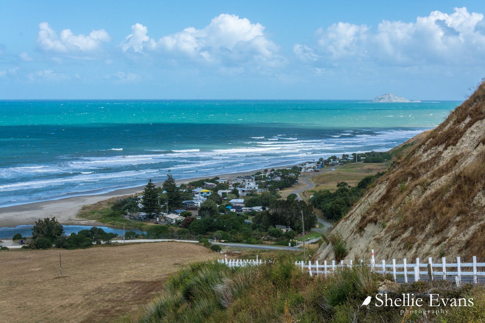

We set up camp in a large paddock courtesy of a local landowner. The wind was up and the weather forecast not too hot but hey, who needs sunny weather when you can rest, relax, laugh and enjoy the company of like-minded camping buddies who just happen to be family.  My two aunties, Pam & Joy (mum's sisters) and their husbands, Gerald & Kevin, are of similar age to me. Pam & Joy are more like sisters and when time and travel allow, we camp together. One occasion that stands out was a very memorable camp on the banks of the Tukituki River a few years ago.

The old surf lifesaving tower brings back a few memories too; I think I might have even been on that deck a few times in my youth! And not by invite either. 'Nough said.


The weather closed in not long after we arrived, it's hard to believe but there were over 600 people on the beach just the day before- Christmas Day was a cracker in the Bay. 


The cold and gusty southerly kept all but the most hardly away from the holiday hotspot.


Cute wee Meg (belonging to Pam & Gerald) was all kitted out for the wet weather. It was fun to have a energetic bundle of energy camping with us; sometimes I do miss not having a pet.


Though Meg wasn't too pleased to be shut inside our van when she spotted her Dad moving the motorhome. I think she really thought they were leaving without her, she shot out the door like greased lightening when I opened it.


This unusual camper with the pop up luton was staying near us too. A great idea for those that might get a little claustrophobic (and hot) sleeping in the roof space.


On the way home from the beach we stopped for a brief look at the 'infamous' Craggy Range walking track on Te Mata Peak. The track was very popular over the holiday period with dozens of people taking the opportunity of walking it before it is returned to its natural state....even though it was not open to the public and on private land.


Originally I was against the track and not just from the iwi perspective (they really should have been consulted- that was very bad of Hastings District Council). Te Mata Peak is an iconic landmark (also an Outstanding Natural Feature) and a very familiar sight to many people. The 2.4km track is a massive scar on an otherwise natural cliff face. 

Personally I wouldn't like to see trees and plants planted along it's edges as had been suggested- then there'd just be green zigzags up the hill- it would need similar grasses planted to soften the lines. The dry grass and exposed rock face is Te Mata Peak, that's a HB summer right there. Now having seen the track though, I am in two minds. I'm sure it would age in time and not be so noticeable. But would people respect the track? Already the corners were worn where people have cut them off, and then there are those 4WD marks up the side...but, will it be returned to it's natural state? Watch this space.

Click on the photo to see how many people were walking the track.
Our second break (and second visit) was to the DOC Camp at Kuripapango, 70kms up the Napier-Taihape Road at the foot of the 'Gentle Annie' a long and winding, slow haul up and over the Kaweka Ranges. 


We arrived a day earlier than the others and initially set up in the same place as we had done on our previous visit (see link above). But it was not to be. Sometimes things just don't flow as they should and after at least 30 minutes of maneuvering, changing and adding to the blocks to get the van level on the uneven ground, and then finally unhitching and setting up camp, we were invaded by thousands upon thousands of tiny native bees. 

Our new camp site under the kanuka but with not so many bees
The air was black with them, the ground even blacker. It sounded like heavy rain on the van as they pummeled the walls and roof. Not only had we parked across a flight path we had backed over a major hatch. They were emerging out of the ground by their hundreds and milling around in a great swirl near the front of our van. Much to David's disgust, it was time to move.

And the reason there were so many? If you look at the photos above you can see great dusky white swathes of kanuka, flowering across the mountain side and right through camp. Kanuka looks similar but is a totally different plant to the famous Manuka (tea-tree). Kanuka is endemic to New Zealand and doesn't produce the highly sought after Manuka honey.


These native bees are a solitary bee (even though the mass together), they don't have hives but dig nest holes in the ground where they take the pollen for their larvae to feed on. As we found out, a nesting area can be riddled with holes giving the impression of a colony and we had one right under the nose of the van. And yes, they do sting- a tiny needle prick that swells and itches. They don't bother you like honey bees but if caught between a rock and hard place (my foot and a croc and then a crooked elbow) they will sting.

Native bee with pollen on it's legs collecting from Kanuka flowers
The others arrived the next day to find that we'd parked where they usually do too! There were still plenty of bees but nowhere near as many as we'd encountered at the other site. We also had fun watching them dig and disappear into the nearby dirt. In the morning tiny piles of dry dirt indicated where they'd left their nests for the day.


The Kuripapango camp is also known as The Oxbow. An oxbow is where a river forms a loop around a land mass and here at Kuripapango the Ngaruroro River forms the loop around the campsite. Unfortunately the land the camp sits on is about 100 metres above the river and it’s a steep walk down to the river bed. 


It was a typical hot humid Hawkes Bay day when we arrived and after all our fluffing around setting up camp I was keen to head down to the river for a swim to cool off. But boy was the water cold, ice cold, it felt like it was straight off the snow. And no matter how many times I ducked under, it didn't warm up but at least it was refreshing.

David checking for trout
When the family arrived, including two of Pam & Geralds' grandchildren- Zara & Hunter, who often go camping and fishing with them- they also found the water too cold to swim in for long. Instead we headed upstream for a walk and for the kids to practice their fishing skills (legs and ankles covered to ward off the an influx of mossies). We saw plenty of trout but the fishers in the family only managed a couple of small fry that either got off or were released.

Zara finds the perfect seat to wait the trout out
Later Zara made pikelets for us on the BBQ while Hunter acted as waiter, handing them around with cream and raspberry jam. I think they have been watching too many cooking shows- we had to score them! Of course it was 10/10.


The weather Gods were against us once again and the next day dawned cold and misty. 


The weather didn't stop us from heading off to do some exploring. This is us driving through the cloud that had settled over the range. We squashed into the vehicles and set off to the end of nearby Lawrence Road to check out a swing bridge.


We stopped at Blowhard Bush (we've walked the track on a better day) on the way and walked into the Troglodyte Cave (means cave dweller, Kevin) to show the kids, and to look for wetas! 

Then we headed to the end of the road  where a long swingbridge crosses another well known Hawkes Bay river, the Tutaekuri. Those that wanted to, crossed back and forth over the bridge. We had no intention of doing the 3 hour tramp from here to another road end at Puketitiri, although I've added it to my 'must do' list (it's probably about 100km by road). There are also a number of tramping tracks that take you to several huts in the ranges. 


Remember to click on the photos to enlarge and view the slide show.

To be continued...

Saturday, January 20

Hitchin' A Ride

Real-time

I had to share this quick blog with you before it becomes history. As you know we're parked on the concrete pad beside Mum & Dads' house here in Napier. A self seeded swan plant (which Mum had been carefully nurturing) had sprouted from a crack in the concrete at the back of the pad and unfortunately when we backed the 5th-wheeler in, the rear of the van went right over the top of it and bent it nearly in half.


Rather than pull it out and have the tiny caterpillars on it die, we let it be, figuring that it was still getting some light and would probably survive. That was back in early December and from my kitchen window I'd often see monarch butterflies flying about hunting for the plant and then disappearing underneath.

We gave the plant a breather and the caterpillars some warm sunshine on their backs for a few days when we pulled out a week or so ago to head to Kuripapango for a few days.  I thought I'd better check underneath to see how the caterpillars were as I'd seen a few crystallises both green and hatched on the nearby fence railings. There were still quite a few caterpillars on the plant but it was more of a surprise to find seven green crystallises attached to the bottom of the van in various places.


We thought about removing them and super-gluing them to a stick so they could hatch in peace but in the end decided they'd be ok under there out of the weather and they'd probably have just as much movement as they would have had on a plant in the wind.

So seven extra passengers came with us on their very own 70km road trip to Kuripapango for a four day holiday. They shared their home away from home with thousands of native bees, a few birds, the odd possum, dozens of sandflies and many other flying insects. 


And seven, still green, passengers returned home with us, all in good health. Over the last few days they have been slowly turning black...


...and emerging from their crystallises. 


Which is just as well as David has been patiently waiting to water blast underneath.


I've now cut the plant off at its base to stop any more butterflies laying eggs before David gets under there. Mum has the plant in a jar of water with the few remaining caterpillars chomping their way through the last of the leaves. There's a funny but sad story there too- after carefully rescuing a fat caterpillar who was off to find a sheltered spot under the van to spin his magic, he then fell off the plant, through a gap in the table and onto the concrete.

Mum carefully returned him to a stable area in the plant but when we went to check on him later he'd headed off again. Mum and I hunted high and low for him; checking the window sills, other plants nearby, under the table the jar was on, everywhere, until suddenly Mum spotted green and black goo squelched out from under my shoe as I stood on the nearby rubber door mat. Hmmm....one fat caterpillar found. And lost.


Meanwhile I've been transferring the butterflies, as they hatch, to the runner bean plants so they can dry out their wings in a sheltered spot. I'm sure they must work on some sort of homing instinct though because it's not long before I see them circling around the back of the van and flying back underneath.


There's just one more chrysalis to hatch, he's turning black as I speak and should be gone by tomorrow evening. David can then get on with his maintenance.


Thursday, February 19

White Cliffs of…..Mangaweka

We said a final farewell to Kuripapango and turned right at the gate. Next stop Mangaweka.

We cross the Ngaruroro River for the last time and start the steady and slow climb up the “Gentle Annie’. From the top of the first climb we look back down on the river and can see part of the oxbow, the camp is around the far side of centre hill. Across the valley is Mt Kuripapango where you can clearly see the track I climbed  running up the ridge.


The ‘Gentle Annie’ was a lot longer than I remember with the road winding it’s way up, down and around for about 10kms. We were a little worried about hauling the van through the range but as it turned out it was a piece of cake compared with some of the roads we’ve travelled in the South Island. Although, going by some fellow RVers we spoke to in camp,  it’s a longer & steeper haul coming the other way, from west to east.

We had a great view of the Central Plateau mountains once we’d finally finished with climbing and were passing through rolling farmland. Some of the largest high country sheep stations in the North Island are located along the Napier-Taihape Road and other than the green crop paddocks the pasture looked bone dry. A long & hot summer has parched the land.


We stopped on the side of the road where I took this panorama looking south east, the Rangitikei River valley is somewhere down there.


We stopped to check out the historic Springvale Suspension Bridge, built in 1925 as the route from Taihape to Hastings became more popular, especially with farmers getting produce to the port in Napier.


And right along side is the new Springvale Bridge, built in 1970.


The reserve beside the bridges is a freedom camping area and would be a great place to stop for a night or two especially if you were a keen trout fisherman. We only stopped to check out the bridge this time. While there this tiny retro caravan on a big road trip pulled into the reserve. I’d seen it the night before camped at Kuripapango. It wasn’t going to be the last time we saw it either.


You can see here that the north facing slopes of the hills behind are very dry.


Further on down the road we speed past a large collection of farm buildings which belong to Erewhon Station, a very large sheep station (originally spelt Erehwon, the reverse of ‘nowhere’)- there’s also another Erewhon Station in the Canterbury high country, I wonder why, is there a connection? Other than both of them being out in the middle of nowhere. In the 1870s this Erewhon Station carried around 80,000 sheep. The wool was taken to Napier by packhorses or mules and quite a few were lost while negotiating the narrow track down and up the Ngaruroro River Gorge- now known as the ‘Gentle Annie’.


Just out of Taihape, David has to screech to a halt, when, as we round a corner, I spot this cute little church on a rise ahead of us. This is Opaea Maori Church, it's beside a marae.


We stopped in Taihape to dump the tanks (which, with careful management, lasted well over the two weeks at Kuripapango) and have a coffee at a cafe. Then we continued on south, now on State Highway One which, as it happens, wasn’t very busy. But it still felt like a 10 lane highway after two weeks out in the wops!

Finally we reached Mangaweka, a small settlement the rest of the country has left behind. Abandoned buildings litter the main street which was bypassed by SH1 back in the 1970s. Adventure tourism and farming are now the mainstays. Although Mangaweka is still famous (in NZ) for two things; a DC3 plane that is now tearooms & the beautiful white cliffs that form a gorge for the Rangitikei River.


We turn off the main road and head down towards the river where there are two camping grounds, one on either side of the river, the commercial campground is across the bridge. A more rustic one with limited amenities is in a reserve just before the bridge- the commercial campground collect the fees ($7pp per night)so there is some connection there. We’ve heard from several people that this one is a great place to stay.


There are two levels to the campground and we’re keen to park up on the lower level beside the river rather than up top where it’s just another grassy patch albeit with beautiful white cliffs as a backdrop.

The road down to the lower level is very narrow and overgrown but I walk ahead and we squeeze through. Luckily it’s soft branches that rub down our sides. Take note of the river level measuring stick! We’d have been outta there quick smart had it started to rain heavily!


Behind us the bridge crosses the river, we hear a gently ‘thump, thump’ as each vehicle crosses. It’s a one way bridge with wooden boards & there’s a 10kph speed restriction.


The Rangiteiki river starts on the eastern slopes of the Kaimanawa Mountains on the Central Plateau and flows southwest for around 185km. For much of it’s course the river flows through steep gorges with high papa rock (greywacke) cliffs. The river is very popular for fishing, canoeing, jet boating and white water rafting. Like the Ngaruroro, this river is running very low,  though we can see that it has crossed the gravel in front of our van very recently as there is still damp mud.

All the photos below have people in them, hard to believe but look carefully, that will give you an indication of the sheer height of the cliffs. They are very impressive and rise near vertical from the river. A sign in the campground warns not to swim underneath the cliffs (ignored by many), due to their soft structure. And not to be too concerned if you hear crashing sounds in the night, very few slips reach the water as the soft face breaks away on a regular basis.

There’s a fly fisherman in the middle left photo, I zoomed in & that’s him on the right. David went fishing both evenings we were at the camp; he hooked one small fish & landed a beauty which he released, much to the pleasure of tourist watching him from a nearby rock. It was a surprise there were any fish in the pool, it was near where everyone went swimming.


The following day we headed inland exploring (more on that in another blog) but stopped over the other side of the river to check out the commercial campground- a nice spot too- and the river & bridge from that side. This is looking towards our camp, you can see our van peeking out of the undergrowth and people down at the river’s edge.


The Mangaweka Bridge first took traffic across the river in 1904 but was never officially opened. The community have finally planned an  ‘Opening & Pioneer Day’ for 7th March, 2015, 111 years later. Better late than never!


It was a tight squeeze getting back out of the lower level but hey, we don’t do things by halves, we do push the boundaries occasionally but that gets us into some special spots.


We had a lovely two days at Mangaweka but we were both keen to get back on the road & head further south, getting ever closer to crossing back to the Mainland.


Wednesday, February 18

Fly Fishing

A few last photos from Kuripapango- David fly fishing the beautiful Ngaruroro River.


As you can see the water is a beautiful green colour and very clear. It makes it hard to fish as they see you coming, but David did manage to catch a few fish but they were all ‘catch & release’. As much as I wanted to have at least one trout for dinner, I was happy they were returned, they deserved to survive after escaping the masses at Waitangi weekend.


From the lookout at the Cameron Carpark, looking down the river towards the DOC camp which is up high around that last bend.


Farewell Kuripapango, we had a wonderful two weeks enjoying the solitude (which was most days even with all those people passing by) and getting back to nature.