Showing posts with label ward. Show all posts

Saturday, December 16

Earthquake- Ward Beach, Marlborough

Catch-up


There were even greater changes around Cape Campbell and down the coast at Ward Beach; closer to Kaikoura and the epicentre of the earthquake. That's the old high tide line at least 30-60cm (1-2 feet) above David's head and the new high-tide line where the green algae ends.

November 2017


Ward Beach, like Marfells DOC Camp, was a regular stop-off point for us before the November 2016 Kaikoura Earthquake. We often spent a few nights at one or the other on our way up State Highway 1 to catch the ferry or when heading south again after a North Island visit. After the 'quake and due to the major damage done to the road and rail network, SH1 was closed at Clarence, 45kms south of Ward. 

July 2014

High tide
The camping area is beside rugged & wild Ward Beach and is located on land that belongs to a local farmer. The site is actually right next door to the Ward Beach Reserve where no camping is allowed, but open the gate and drive on through & anyone with a CSC (certified self-contained) vehicle can camp on the other side of the fence for a small donation to the farmer, to be left in his letterbox back up the road.  

February 2015

Low tide
Once again I've been able to compare pre-'quake photos I had of Ward Beach with the ones I took when we visited the beach while staying at Marfells. I didn't have too many that are direct comparisons but you can still see a huge difference in the rocks that protect each side of the tiny beach (I have no idea why I didn't think to check the old ones out before the visit so I could take the new ones in the same spot!).

Remember to click the first photo to take you to a slide show and then use your back and forward arrows to view them enlarged and side by side.

November 2017- After the 'quake showing the rocks to the left of beach. In the two photos above you can see the same rocks before the event.


February 2015- down on the beach 


November 2017- This photo is a bit deceptive because the rocks you can see in the photo above are the rocks on the hard left and out of shot in the photo below. The rocks on the right were under water above.  


February 2015- before the earthquake a local crayfishing company launched their boats from a 'dozer at the beach most mornings. Since the 'quake, they have been unable to due to the shallow bay and exposed rocks. They have also been unable to get resource consent to launch them further up the coast. Sadly, they have become another one of the many businesses up and down the Kaikoura Coast that have suffered in the aftermath of the 'quake. 


November 2017- the vertical slabs of rocks on the right appear to be the same ones behind the boat in the photo above.


July 2014- On the right-hand side of the small beach the Flaxbourne River flows into the sea.


November 2017- you can certainly see the difference here after the 'quake, the gravel banks on both sides of the river and the rocky outcrop at the outlet have been pushed up...


...blocking off the river mouth- November 2017.


February 2015- before the 'quake and on the other side of the rivermouth looking back towards Ward Beach


February 2015- an arrow marks submerged rocks...


November 2017- that are now exposed.


And three more comparison shots.

Two photos from slightly different angles- February 2015


And the comparison shot- November 2017


It's not until we get up close to the rocks on the left side of the beach that it becomes apparent how far the earthquake has actually lifted the seabed. Before the 'quake most of these would have been under the water with just the tops of the bigger rocks sticking out in the wave zone.


The rocks now tower over us as we walk around them- before the 'quake we'd have had to wear wetsuits, fins and a snorkle to explore. Green algae grows below the new high tide line.


The rock David is examining is now 'beached' with no low tide mark on this side, yet the high tide line before the quake is 30-60mm above his head.


Up close, the remains of seaweed and shellfish cover the crumbling rock.


Dried stumps of seaweed...


...long dead shellfish hiding in their rocky holes and large carpets of barnacles are all that remain on the bleached rocks.


The rocky reef and papa rock platform at Ward Beach was once covered in great trails and thick forests of bull kelp that swirled back and forward in the waves, rising and falling with the tide. 

February 2015-


This was once home to a diverse coastal ecosystem; crayfish, paua (abalone), green-lipped mussels, other shellfish and fish lived and sought shelter in the channels and caves around the reef. 

And this was the heartbreaking sight that greeted locals in the days after the 'quake (photo supplied). 

November 2016


One year on and the coastal landscape has gone through another dramatic change from those early days after the Kaikoura Earthquake.

November 2017- taken from the same position as the photo above (coincidentally) 


I know that there were several RVers parked at Ward Beach (and Marfells) on the night of the 'quake; we met a couple who had been at the beach a few days later at our Franz Josef camp site- they were still visibly shaken. They had dashed as far away as they could from the continuous aftershocks, along broken roads and past crumbling buildings, to the West Coast.

They were still cleaning up their van after the violent jolt threw open their drawers, cupboards and fridge and dumped clothes, crockery and food in one big broken jumble on the floor. They had to climb over the pile, in the darkness, to get to the door to escape. After the initial big shake and with the worry of a tsunami, they gathered together with the other campers in the darkness and then all made their way back up the road to the farm homestead, cautiously checking for rock slides along the way. 

In time people will forget how the beach looked before the 'quake or not even be aware of the dramatic changes that happened back in the middle of a dark night in November 2016. It will still be a wild and beautiful beach with amazing sunrises. 

July 2014
And people will still come to steal a quiet moment, sitting in their cars mesmerized by the crashing waves or sheltered from howling wind. They'll still come to relax, fish or explore the rocky shoreline (now with even more rocks and pools) and should they know of it's history, marvel in wonder at Mother Nature's incredible force. 

July 2014


Saturday, August 22

Northbound along the Pacific Coast

An update post on our whereabouts; we’re moving quite quickly up the east coast heading for the top of the South Island at the moment.

Can you believe it? I didn’t take any photos while we were parked for 5 nights at Weedons in Christchurch. Probably because other than the day we arrived it was cold and wet for most of the time. I also spent alot of time catching up on photos and blog posts and didn’t want to add to the pile!
 
Typical Murphy’s Law though, the weather cleared as we hitched up to head out of Christchurch.We thought we might head to the NZMCA Park at Parnassus but it looked a little lonely & forlorn as we drove by, so we carried on, heading for Kaikoura.

Here’s us parked at the NZMCA Park which is beside the Kaikoura racecourse, it’s not the most photogenic site at ground level surrounded by loose boxes and open stalls but take the stairway up behind and the views are fabulous out over South Bay. The walkway crosses farmland behind and ends up in town, not on the Kaikoura Peninsula Walkway as I found out the last time we stopped here (there are plenty of links to click on in this post- they are the posts from our last visits)


We left the van hitched to the ute for the night, we often do that if we’re just staying overnight, it saves a little time in the morning. That was until I decided I should nip around the corner and out to Kean Point to check out the seals and especially the seal pups. There’s always adult or teenage seals at the point, lounging about in the carpark and over the boardwalk…


…and at this time of the year there are plenty of super cute seal pups wandering about or sleeping under the bushes. This slick little wet guy was keen to check me out and waddled along the bottom of the wall until he came to the steps which he then bounded up. He then decided to explore a puddle in the carpark and when I moved in to take a photo he mock charged me. He then charged a few others that approached him, he was having fun, he’d follow people along the road and when they stopped to say hello he’d charge them. Little tyke.


Then he decided to follow me up another stairway to where his playmates were sleeping under the bushes on a bank. He climbed over the concrete wall beside the steps, they are quite agile considering how awkward they look moving about and then made a nuisance of himself by clambering over the sleeping beauties. They didn’t seem to mind and either rolled over or curled back up to continue sleeping. Doesn’t the pup on the left look odd with it’s neck resting on a branch, he’s obviously had some good meals from Mum.

Other seals from the colony rested on the rock stacks beside the car park with the snow covered Kaikoura Range as a backdrop.


As I was driving back home I noticed the setting sun was causing some dark rays reaching down to the horizon out at sea. At first I thought it might have been my eyes and the angle I was looking through the glass of the car window. I pulled over to take some photos. These are called crepuscular rays, rays that stream through gaps in the clouds that are columns of sunlit air separated by darker cloud-shadowed regions. So in fact the darker lines aren’t the rays, they’re the cloud shadow, the lighter areas beside them are the rays.


The next day we stopped at a number of places of interest north of Kaikoura, the first was to check a rocky point where I’d seen dozens of Spotted Shags/Parekareka nesting the last time we passed by. There were just half a dozen early birds (cool- double entendre ;)) preparing their nests in the best spots; the deepest ledge on the vertical rock face.


I wonder how many chicks tumble over the edge and into the ocean below each season, last time I was here there were nests tucked into some very precarious spots on the wall above this prized ledge.


And of course the next stop had to be at Ohau Point to see the seal pup nursery at the waterfall. The last time we called here there were 50-60 pups clambering up the stream to the waterfall and swimming in the pool at the foot of the falls but it’s getting late in the season now and while there were dozens of bigger pups sunning themselves and sleeping on the rocks beside the sea there were only half a dozen smaller pups up near the waterfall and just one lone little guy swirling and flipping under the falls. This pair were keeping each other company near the stream, the one on the left wasn’t worried about me but his friend kept a wary eye(or two) on my movements.


So that’s what they mean about having eyes in the back of your head! And as you can see, they have HUGE eyes.


There’s a freedom camping area on the seaward side of the main highway at Paparoa Point, there’s also a seal colony nearby that ponged to high heaven and masses of tiny flies that had settled over the back of this caravan whose owners were certainly going to get a shock when they came home from exploring.


Our next stop over is at one our favourite places along the Marlborough/Canterbury coastline; the rugged and windswept Ward Beach. The camping area is part of a farm and is beside the Ward Reserve. An area has been cleared and fenced right above the beach and as long as you’re CSC (certified self-contained) and pay a donation to the farm owners, you’re welcome to stay.


There’s a garden of painted stones from visitors past and a pile of sturdy walking sticks at the gate. You’ll need a stick if you go for a walk, the beach is deep gravel and takes a bit of energy to walk over.


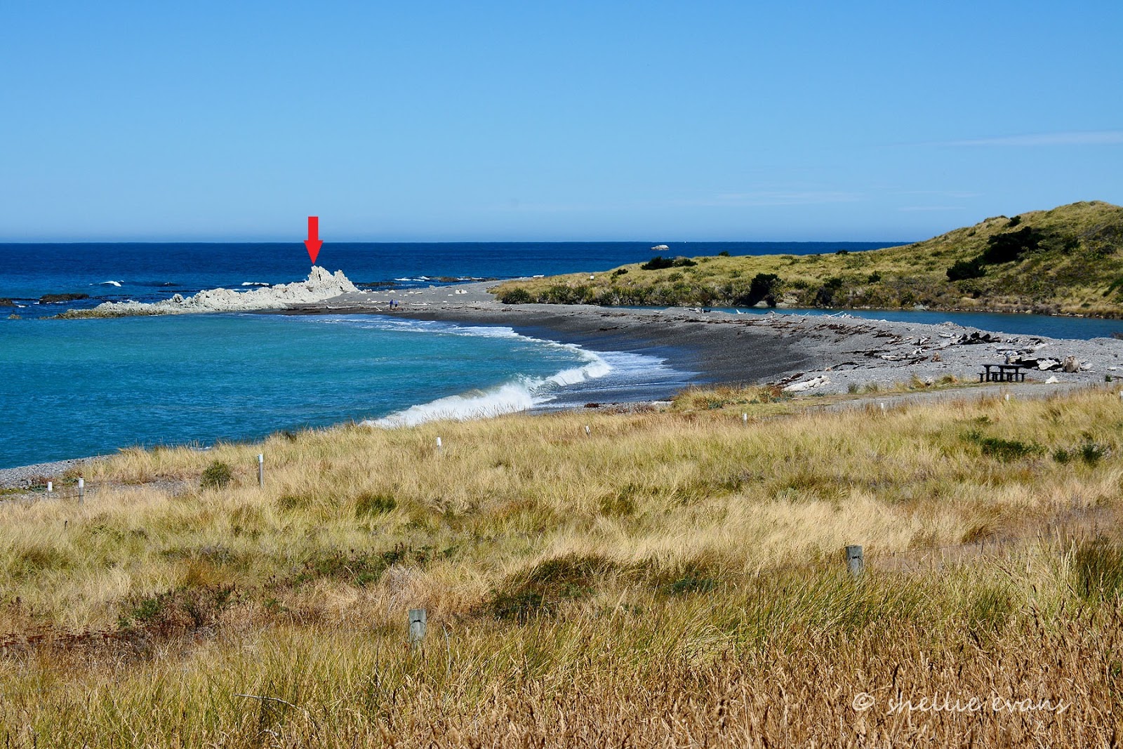
But its well worth a walk up the beach towards Cape Campbell where there are some huge limestone rock formations and a seal colony. We didn’t venture up there this time, I took this photo back in February….roll on summer!


I’ve been half-heartedly trying to catch the Aurora Australis (aka the Southern Lights) while we’ve been travelling the south but I either miss the night they play with spectacular colours for all to see with the naked eye or I forget to look to see what the prediction is when we are in a good viewing area. A couple of times I’ve found out too late or we’ve been parked in town or behind a hill or it’s way too cold or there’s no water for a reflection. Now that we’re moving north it’s getting harder to find the right area, I kicked myself last Saturday night (well actually Sunday morning) when we were parked at Kakanui on the cliff edge with a perfect view south and the lights put on a fantastic show…..while I slept on. I forgot all about it.

So I thought I might pick up a little of the lights from Ward beach if the call went out that the solar activity was increasing. So I set up the camera and waited….and waited. My activity alerts headed in the wrong direction, it was all quite on the southern front. I did get a few shots of the Milky Way and a little colour from around the edge of the huge hill in front of me but I’m thinking they are the light glare from Christchurch.


Now I’ll just have to wait until we’re back in down South to try again. I did do a shoot while we were in Winton, I drove around to the sports field on the edge of town where it was nice and dark, set my gear up and waited in the freezing cold with snow all around me. I didn’t last long, the first shots showed me that I had a two bloody power lines straight through the centre of the photo. Memo to ones self- check the view out before it gets dark.

Finally, after numerous visits to Ward Beach, we got to see the bulldozer launch the crayfishing boat off the beach. Every other stop the sea has been too rough. So when I heard a loud rumble early this morning I shot out of bed, threw on some clothes and grabbed my camera. The boats are stored in shed back up the road and the bulldozers are kept near where we’re parked.


Now you can see how loose the gravel is, and how hard the bulldozer has to work to tow the boat through.


The boat is backed into the water on the quiet side of the small bay and released from the cradle, it great to see it’s a cat (catamaran), perfect for the rough seas and a stable platform while they’re lifting and setting the cray pots (Ok Shellie, you’re not selling boats now)…


…the skipper then waits for the driver to park the ‘dozer….


…and board before they roar off up the coast.


We left before they returned and, not that they would have showed us, but I wonder what their catch was like. We stopped at one of the crayfish stalls on the main road north of Kaikoura the other day just to see how much they were charging. I nearly fell over, $78, SEVENTY EIGHT DOLLARS for the tiniest of crays a cray that looked more like a large prawn than a crayfish. And with two rental motorhomes and around six tourists eating a pile of crayfish on the table beside the stall they obviously have no trouble selling them.

We're now parked at another favourite of ours on the coast; the DOC Camp at Marfells Beach, just south of Seddon and beside the Grassmere Salt Lakes. Oh, it's a tough life...


Back to the Maniototo posts soon….


Monday, February 23

Back on the Mainland

Leaving Mangaweka we continued on heading south. We took SH54, the scenic route, turning off the main road at Vinegar Hill. At the bottom of Vinegar Hill is reserve beside the river where freedom camping is allowed. Luckily it wasn’t one I chose to stay at on our way through; it was a beautiful spot, a large grassy area under trees on the edge of the river sheltered by those ever present white cliffs. But the entrance was a narrow and low tunnel through thick bush, there would be no way anything larger than a small campervan would get through. More’s the pity, as I’m sure it would be a very popular spot- maybe that is why they keep the trees low!

The road's quite twisty with a lot of climbing as we wound our way up and over the many river plateaus that have formed over hundreds of thousands of years. The lookout at the top had 180 degree views looking west out over farmland. I should have done a panorama, this shot is looking north west, the direction we had come from.


Foxton Beach was our next stop, we’d decided on a camp ground as we needed to do some laundry, give the batteries a boost after being off the grid for over two weeks and have a decent long hot shower- even though there were signs everywhere stating “5 Minute Showers Only Please!”. We figured as we were the only ones in camp there’d be nobody lining up to use them.

Foxton Beach Campground is obviously a very busy camp in the height of the season, it’s large and sprawling. There are many semi permanent baches that looked to be owned (or leased) in the campground. Most have a caravan with a ‘lean to’ attached- I would say this must be part of the rules; able to be moved off the site and not leave a trace. Although looking at some of the more elaborate ones I guess that will never happen. Most have a quad bike garage attached too, the best mode of transport in beach communities. There are many batches for sale.


The camp is beside a river and on the edge of the beach but there is no easy access to the beach as there are a lot of high dunes between the sea and the camp. There’s also no access gates through the fence or tracks at the back of the camp. Instead a sandy vehicle track follows the river to it’s mouth and at low tide you can drive right around out onto the beach. We did.

There are plenty of signs regarding driving on the beach- it’s to be treated as a legal road, all drivers must be licensed, helmets must be worn if on a bike and the speed limit is 30kp/h. You also must stick to the hard sand, definitely no dune driving. It reminds us of Oreti Beach near Invercargill in the deep south, we had a lovely day there with the family back at the beginning of our travels. It looks like it must stretch as far too, disappearing over the horizon. We drive up the beach until we reach the Foxton Beach Surf Club where there is another entrance/exit to the beach.

We think about coming back in the morning and maybe doing a bit of fishing but I’ve been watching the weather and Friday is the best window of opportunity to have a calm Strait crossing;  a fine day between rough seas and high winds. Foxton fishing will have to wait.


We leave Foxton Thursday morning, heading for Evans Bay in central Wellington where we’ll stay the night before catching the 8am sailing with Bluebridge on Friday morning. We pull into Queen Elizabeth Park near Paekakariki for lunch, driving through the park to the beach front but stopping on the way to view the US Marine Memorial.


It’s a very interesting and informative memorial, there are six ‘hut’ walls with information panels on them, at the rear of the walls is another memorial, part of a LCVP (landing craft, vehicle & personnel) with the names of ten men that lost their lives in rough seas while on an exercise off the beach nearby.

Over 15,000 US Marines camped in the area during WWII, this was the training base for infantry regiments preparing to fight the Japanese in the Pacific and help defend NZ if it had been attacked. NZ solders were away fighting in North Africa & Europe and couldn’t be spared. British Prime Minister, Winston Churchill asked the US President Roosevelt to send a division of US Marine troops to NZ. The first US Marines arrived in mid 1942 and the last left in late 1943. Troops returned to Paekakariki for R&R after battles in the Pacific and were not always welcomed by the locals & the missing NZ troops who called the Marines 'bedroom commandos'. Over 500 marines married Kiwi women.


We made it safely through the Wellington City traffic and pulled into Evans Bay mid afternoon. What a transformation this free camping area has gone through since our last stop there, on our way to the North Island last November. Then it had only just been given the green light as an parking spot and we were the only ones in overnight. Fast forward 3 months and it was like Piccadilly Station, at last count around 10pm there were 27 vans & sleeper cars parked up- it’s meant to be for CSS vehicles (certified self-contained) but at least half of the overnighters were in cars that would not have been self-contained. I can see that this will be another site we’ll lose because people don’t follow the rules.

We had to ask a couple of vans to move as they parked outside the marked parks & too close to the corner which we had to pull around at 6am in the morning. One of them, a large motorhome, pulled in at around 11:30pm and parked mostly in the drive right in front of us. I don’t think David got an hours sleep all night, every vehicle he heard he was sure it was going to park right in front of us- I told him not to worry, I'd be happy to knock on their window at 5:30am. And before anybody asks, yes we’re taking up more space than most- it was all mostly clear when we arrived. We pulled into a double park but were overhanging too much. It is actually a large carpark but most wanted to park down our end away from the corner traffic noise I think.


We were up and gone just after 6am and were lined up to board the ferry by 6:30am, missing all the morning traffic through the city. David had no problems driving on, we were squashed into place between two large trucks near the front. We found ourselves a comfy seat upstairs and settled in for a boring 3 hours. I always forget to bring something to read and the movie wasn’t that great. I did go outside a number of times but between the diesel and cow poop smell (a stock truck was directly below the back deck) it wasn’t a pleasant experience. Mind you the strong coffee smell inside wasn’t much better. As I had hoped & planned for, it was a smooth crossing and not before time we were pulling into Picton once again.


We were hoping to call in and see friends in Picton before heading off but they were out of town for a few days. Initially we had planned on leaving the van at Nelson Lakes & then driving the Rainbow Road & Molesworth Station over two days, staying in Hanmer overnight, before picking the van up again and heading west. These plans were thrown into disarray when the Molesworth Station road was closed a few weeks ago due to the high fire risk because of the extreme drought situation over much of the South Island.

We decided to head east to Ward Beach for a few days, then catch our friends next week before heading west to Murchison. Some of you will remember Ward Beach from when we stayed there last July, in the middle of winter!

The transformation of the surrounding hills, since we last passed through this area, is amazing. It’s bone dry everywhere you look except, of course, for the bright green of the many vineyards.


There’s not much stock in the paddocks although I do see a few lonely (and hungry, no doubt) sheep & cattle here and there.


Near Dashwood Pass we can see where a grass fire has burnt out a large area. I recall when this happened back in January and the main highway was closed for a few hours as they fought the fire. Toady we’re stopped for a short time at road works.


Finally we pull into the camp site at Ward Beach, once again we’re surprised, it’s looking much more inviting than it was when we were here in winter- last time the sun (when it made an appearance) disappeared behind the hill before 3pm, now it's about 5:30pm.  It’s also amazing how a fine day can change your outlook. This time we’re not the only van in camp, there are 6 or 7 parked up and they come and go all weekend.


The land belongs to a local farmer and is right beside the beach reserve. All he asks for is a donation and you can stay for as long as you like. It’s strictly for CSS vehicles only and there is no fresh water available. It’s a beautiful spot and if you’re a keen diver, paua & crayfish can be found just off shore. This morning a pod of dolphins frolicked around the rocks offshore, we think they may have been the tiny and rare Hectors dolphins.

Here's the camp today and below it, the camp last July. The river on the right has now dried up and there's just a large stagnant pool near the rocky bank.


Next - Unfinished Business.
I wonder how many might know what we do next….