Showing posts with label whanganui. Show all posts

Tuesday, February 7

Bushy Park Forest Sanctuary, Kai Iwi, Whanganui

Surrounding the historic Bushy Park homestead is the 89 hectare Bushy Park Tarapuruhi Forest which is a Forest & Bird Project.  


The forest is a rare example of North Island temperate lowland forest. Lowland forests such as Bushy Park historically harboured the largest and most diverse communities of native and endemic plants and animals. 


Bushy Park Tarapuruhi is unusual in that it survived (most lowland forest was clear felled) and it is relatively unmodified; there has been no logging or burning of the main forest. It was also fenced to exclude domestic livestock in the mid/early 1900s and is now surrounded by a 4.8km pest & predator fence protecting the forest and birdlife from introduced mammals.

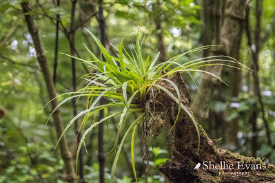
Astelia epiphyte 
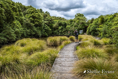
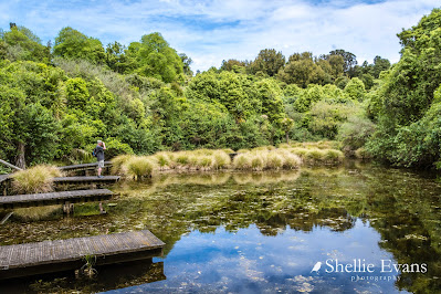
David searching for frogs. They were having their very own concert in the Bushy Parks wetland. But so typical of frogs, they stopped as soon as they spotted us.


I think the little jetties are so school & other education groups can check out the pond for bugs & insects.


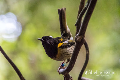
A male Hihi/Stitchbird on high alert. There's a feed station nearby & several males are trying to use it hence this one zipping about chasing them.

The stitchbird was both rare and poorly known about until the 1990s as few people had an opportunity to visit the single remnant population on Little Barrier Island. With careful management & conservation Hihi can now be seen at several protected sanctuaries.

The female Hihi/Stitchbird is hardly ever seen because the boys take over the feed stations. This one approached but was soon seen off (hence the blurry photo, you have got to be quick to capture them!).

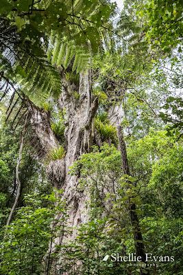
Ratanui the big rata tree of Tarapuruhi/Bushy Park is 36.2mtrs tall. Hard to believe that this rata started out as a small vine that grew up it's host tree and then sent out roots down to the ground, became established & slowly swallowed up its host (often a rimu). And look at all those 'widow makers', large clumps of the epiphyte astelia. Epiphytes growing on a tree that started life as an epiphyte.


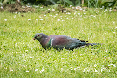
A big plump Kereru/Wood pigeon grazes on the homestead's front lawn. Our native pigeons often graze on the ground in large flocks, I once saw a group of around 50 or so birds in a paddock in Golden Bay. And if they're not grazing they are often being goof-balls, chasing each other, rolling over, doing mock attacks & aerobatics just off the ground.


There were so many Tieke/Saddleback in the forest, they were calling to each other, flying about & pulling apart rotting trees on the ground & scratching about in the forest litter but they are very hard to take a photo as it's so dark in the bush & they are so fast in amongst the tangle of undergrowth. So as I was checking out the homestead garden...


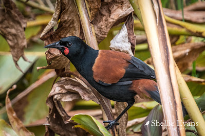
... I don't know who got the biggest fright, me or the Tieke when I heard some rustling in the undergrowth & crept up to see what it might be. And look who popped out!

Tieke are endemic (found only in NZ) and classed as 'relic'- a small population stabilised after declining. North Island Saddlebacks (and South Island Saddlebacks) are found only on predator free islands or in protected mainland sanctuaries. Because they are weak fliers & spend a lot of time on and near the ground they are easy prey for predators especially rats & stoats.

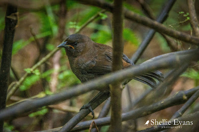
Did you know that the South Island Saddleback/Tieke has a different coloured juvenile to the North Island Tieke? South Island juveniles (commonly referred to as ‘jackbirds’) are covered entirely in chocolate brown plumage for their first year whereas North Island juveniles have the adult black plumage with the beginnings of the coloured saddle. 

Tieke/Saddleback Jackbird- Ulva Island, Rakiura/Stewart Island

The homestead's lower carpark is also a POP #4565 (park over property), with a maximum of 3 vehicles a night at $20 for two people ($7 extra person). We visited Bushy Park in the ute but thought it would be great to stay & wake up to a dawn chorus although I think our size rig would be borderline getting up the narrow drive & manoeuvring around in the carpark.  


Friday, January 27

Bushy Park Homestead, Whanganui

Let's see how this goes. As most of you will know or have gathered  I have been struggling to write blogs over the last couple of years. I have so much else happening with various social media accounts & websites to update plus photographs to take & process that my blogs have taken a back seat. I tend to usually write long & detailed blogs with lots of photos & this along with the research I need to do on the area I'm writing about usually ties me up for quite a number of hours over several days. 

I'm now going see if I can do shorter blogs with not so many photos & detail & post more frequently. Many of the blogs will follow a similar format to the photos & information I post on my Facebook page so there might be a bit of  doubling up but I know I have quite a number of followers that don't do Facebook so it'll be new to them. Fingers crossed this works otherwise I might have to put my blog to sleep for awhile. 

Bushy Park Homestead

Bushy Park Homestead

Bushy Park Homestead is an Edwardian-era homestead registered as a Category I heritage building by Heritage New Zealand. It is located in Bushy Park, near Kai Iwi, Whanganui, in the Manawatu-Whanganui region.

Entrance
Sitting Room
Formal Dinning Room
The 22-room Edwardian homestead, designed by Charles Tilleard Natusch, includes a 109 feet (33 m) long, 6 feet (1.8 m)-wide hall that runs the length of the residence, as well as wood panelling, carved mantels, and Art Deco lights.

Breakfast Room
Built by Russell and Bignell in 1906 at a cost of £4,566 for G. Frank Moore, a cattle and racehorse breeder, the residence and park were given to the Royal Forest and Bird Protection Society of New Zealand by Moore in 1962. The homestead, bird sanctuary, and rain forest have been managed by Bushy Park Homestead and Forest Trust since 1994.
Lounge
Bushy Park Homestead is a fully licenced five-bedroom bed and breakfast homestay and function venue.
Lounge
For a gold coin donation visitors can tour the homestead although if there are guests only one end of the house is open (there were guests when I had a look). You can also have a cold drink or Devonshire tea on the veranda.

Veranda View

Saturday, March 17

Mokau Landing- Lake Waikaremoana, East Coast

Catch-up

We left Lake Tutira Friday morning heading north up the East Coast towards our next stop. It's been a very long time since I've travelled SH2 north of Tutira, when I was younger it was the route to our family summer holidays at Mahia and I also used to visit a farm (and the Waikare Pub) at Putorino with friends whose family lived nearby. 

I was keen to see the familiar settlements along the way; Putorino, Kotemaori and Raupunga but most of all I was looking forward to seeing the Mohaka Viaduct again. And there it was as we rounded a corner; just as I remember it, one massive, slightly rickety looking viaduct spanning the mighty Mohaka River far below. 


With no lookout to stop at, it was a matter of grabbing a few photos as we approached the viaduct, went under it, then as we crossed the river and one last one just before we disappeared over the top on the other side. 

Once the 4th highest viaduct in the world and still the highest in Australasia, the 95 metre, NZ Heritage Grade 1 listed viaduct, was opened in 1937 and was in regular use until the Napier to Gisborne rail line was mothballed in 2012. Though, just in the last month or so, KiwiRail and the Labour Government have announced that towards the end of the year, logging trains will recommence using the line on weekends from Wairoa to Napier. That's going to give a few people who live along the line a bit of a fright as they once again get used to looking out for trains.


We stopped in Wairoa for a few supplies and then headed off to our next destination, keen to get there before the weather turned on us (it had been a dull grey day so far) and the weekend campers arrived. 

We were headed to the remote Mokau Landing DOC camp on the shores of Lake Waikaremoana, 77kms inland and deep inside Te Urewera National Park. We were holding out hope that the tarseal would last most of the way but it came as no surprise when it ran out with still 39kms to travel. 

Ignore the time to travel, there was a glitch in the system this day.
And now we wished it was raining, just a light sprinkle to deaden the dust! There were several short random sections of seal here and there though; some past farm homesteads for obviously reasons but others for no apparent reason. 

Much of the gravel road was deeply corrugated and I felt sorry for David as he cursed and mumbled under his breath. He'd spent the last few weeks polishing, painting underneath and cleaning the rig. By the time we arrived at the camp a thick layer of dust coated it  from top to bottom. 


There was no time to stop for photos at the top of the climb above the Tuai Power Station and Lake Whakamarino or looking down the other side to Lake Waikaremoana. I was hoping that I'd be able to return to Tuai at a more leisurely pace sometime during our stay.

Mum has a cousin, who with his family, lived at Tuai for many years. He was a local Maori elder/Kaumātua and a water taxi skipper for trampers on the lake's Great Walk. He was killed tragically in an quad bike accident a few years ago. During our stay I did manage to speak to several people who knew Noel well. Unfortunately I didn't get back to Tuai, the road and the weather kept us at Mokau.

Sign? What Sign?
It's 12kms from the Waikaremoana campground to the DOC camp at Mokau Landing. The road is even narrower and windier than we've already experienced. With very few places to pull over and many blind corners we were lucky to not have met anyone coming the other way.

This is State Highway 38 from Wairoa to Murupara and beyond. It finishes at Rainbow Mountain in the Rotorua District, a 200km long winding road, much of it gravel through a very remote and beautiful part of New Zealand. It's called the Te Urewera Rainbow Route and is touted to tourists as a stunning scenic drive. And it is. But I bet the tourists that drive it are very pleased when they reach the other end. You only want to do this road once in your lifetime. We have driven it- there and back- a very long time ago in our regular car. We have no intentions of repeating the exercise!


Finally we reach the turn off down into the Mokau Landing Camp. We're half way down the track before we realise that this is even narrower than the road. I got out to check around the blind corner, to make sure no one was heading up and when I looked back I could see David was suddenly more concerned with getting around the corner. There's no turning back now.


I needn't have worried about how busy the camp might have been over the weekend which was one of the reasons we left Tutira on Friday. Mokau is a large site with several areas to park- beside the Mokau Inlet and stream, at the back of the reserve, on the lake front or round the corner in a bush clearing tucked into another bay (a lovely spot but with no views of the lake). We set up right on the lake front and not far from the boat ramp.


There was one other couple and their caravan when we arrived and we had 3 or 4 others come in over the weekend and then we were on our own again for the rest of the week with the caravan couple (hi Chris & Bernard!) and one or two tourist campers in each night. Folk who just couldn't go any further after driving the Rainbow Road me thinks! So far we've seen none of the overcrowded camps in the North Island that many people have complained about. But then again, we tend to visit the more remote places or ones off the usual beaten track. We'll see how we go the further north we head.

Photos clockwise- Mokau Landing DOC Camp, Wairoa Anglers Lodge at the rear of the camp, lake front view, sunset at Lake Waikaremoana and a friendly White-faced heron/Matuku Moana who sunbathed each evening on a nearby clump of dirt.


The Panekire Bluffs are a prominent feature of Lake Waikaremoana and can be seen from many different vantage points around the lake. The Lake Waikaremoana Great Walk starts off to the left of the bluffs at Onepoto and passes along the ridgeline on the very first day of the 3-4 day walk. 


David had the Takacat up and ready to go not long after we arrived and contrary to a few comments from other fisherman about the fishing being hard, managed to catch four trout on two outings. Usually a catch & release fisherman, it was time to bring one home for dinner. In fact he bought two home in the end because I had a new recipe I wanted to try out. We smoked the other one. 


I went on a couple of exploratory trips with David in between his fishing...


...one to see a waterfall he'd found. He'd seen it in good light as the sun went down but by the time we arrived back, the sun had disappeared. And bobbing about in a little rubber dinghy is not conducive to getting a slow-mo shot of the water falling, but still, it was a lovely setting.

There was another reason we headed out in the boat several times with no particular place to visit; we had no cellphone or internet reception at the camp but if we motored out into the bay we managed to pick up a Vodafone signal. Normally having no reception wouldn't be a problem, we enjoy the break, but with two family birthdays during the week we were able to give them a call and wish them Happy Birthday while bobbing about on the water! (the red cord David is holding is the quick-cut line to the outboard).


On one trip we pulled onto this tiny beach to have lunch. David found quite a large abandoned camp site in the bush behind- grass flattened, neatly stacked woodpile, fire pit and a few missing trees; obviously a family has holidayed there over summer.


I thought I might like to walk a section of the last part of the Great Walk while David went fishing, but in the end I decided that part of the track wasn't too interesting though he did drop me off to check out the Whanganui Hut. Many of the Great Walk walkers get picked up by the water taxi near the hut and don't walk the last section to the road (you can see the road cutting around the bluff in the third photo below). 

I spoke to several walkers who had just arrived and I talked to a hunter who had returned to the hut with his catch; sadly an older fawn. He was a little embarrassed as he'd been after it's mother but instead shot the youngster when it stuck it's head out instead of the mother. The walkers were horrified that some one had been shooting nearby. He assured them that it was at least 500mtrs from the track as required by his permit but still, I'm not so sure I'd have felt safe with somebody shooting nearby. We're told that the Mokau camp is very busy during the 'roar' (April/May); can you imagine that! Not a good time to go camping if you don't like hunting.


Mokau Falls- this beautiful cascade of water is at the head of the Mokau Inlet, and feeds the lake via a short stream beside the camp. There's a viewing area back up on the road,  you can see the road bridge which passes over the stream on the other side of the inlet, in the photo.


The Mokau Inlet has a unique feature, there are in fact two waterfalls entering the inlet, the Tauwhare Falls are on the opposite side to the Mokau Falls and can only just be seen through the dense bush (not helped by the fact that the sun doesn't shine in there either). I couldn't see them but I could certainly hear them from the Mokau lookout. I had to drive over to the bridge to catch sight of them. That's the edge of the Mokau Falls at the bottom of the photo, a very cool edge for a waterfall. I wonder how many people have climbed down there and peered over the edge. 


Once I had finished taking photos of the waterfalls, I drove up to the top of the road hoping to get a view through the bush overlooking the campsite. This was my first stop; you can't see the camp, that's off to the right but it's overlooking the bay and the other finger of lake where we explored and where the hut is located. We didn't stop for lunch at the beach you can see, ours was not far around the next point.


 I stopped a few more times and finally managed to get a clear line of sight down to the camp.


Friday, September 12

Anatori - The End of the Road ; Part 1

Remember the three long Golden Bay roads I mentioned in a previous post?. Well, we've explored the two up the Cobb & Aorere Valleys and now we’re about to do the final one which also happens to be the longest one at 44kms. It’s also the most westerly road in South Island and probably the least travelled as there is nothing at the end of it other than a small settlement with a handful of houses. And even though we will follow the road down the west coast of the South Island, it’s still part of Golden Bay with no way through to the actual West Coast province.

It’s going to be a 116km round trip from Collingwood for us & mostly on a gravel road plus we’ll add another 20 kms to the total by taking a side road to check out the Kaihoka Lakes.


There are two small lakes in the Kaihoka Scenic Reserve and they are tucked in behind some dramatic coastal hills and bluffs, we can hear the rumble of the surf coming to us over some dunes at the top of the second lake.


A special feature of the lakes are the massed nikau palms which give the 10 minute walk between the lakes a tropical feel. The nikau also confirm we’re on the west coast now, where they are always a prominent feature.

The raft (below) was well made using mussel floats and was tethered just around a corner near the entrance to the walk, maybe the local kids use it or DOC to get to the other side of the lake. We've seen a lot of lost mussel floats on our travels; there’s a mussel farm out in the bay just north of Collingwood and they must break free on a regular basis. For some it’s finders keepers, others call the company who pay $10 for each recovered buoy.


We decide to drive to the end of Kaihoka Lakes Road as it’s skirts around the top western side of one of the largest estuaries in New Zealand, the Westhaven Estuary (Whanganui Inlet). Below is just a tiny section near Pecks Point, we’ll be following the road around the the edge of the estuary on the far side when we get back to the Anatori road.


The gravel road winds in and around the exposed mudflats for 6 of so kilometres, which, as I’ve said before, always feels like double the distance. There’s nothing much more than a farm at the end of the lakes road and they obviously get a few vehicles arriving at their farm gate as they've made a little turning bay with a helpful sign.


We head back to the Anatori road and start the journey south. It’s not long before this sign makes an appearance. Bloody hell, that’s a long way to wind!


Thankfully it’s actually an interesting winding road as it follows the estuary shoreline all the way, cutting across the many estuary ‘fingers’ over embankments and small bridges, where the mudflats reach far up into the hills and where rivers & streams enter. It comes as no surprise to see that the name of this road is Dry Road. Clouds of dust swirl behind us and I know David will be thinking about how much will be finding it’s way into the back.


This is looking across towards the Kaihoka Lakes Road, the farm gate was at about the low point in the hills, centre right.


There are a few isolated houses tucked up in the bush overlooking the estuary along the way and then, once again, we pass through a part of the Kahurangi National Park (kahu= hawk, rangi= God of the sky). At various spots we see three white herons (kotuku) feeding but they’re too far away to get any decent shots. We also pass the end of the Kaituna Track, that’s the track that started beside the Naked Possum Cafe in the Aorere Valley.


Finally I see the ocean's entrance to the estuary and we stop so I can get a shot. The NZ Post rural mail lady in her bright red car comes flying around the corner not long after and pulls to a stop to tell me it looks even better when the tide is in. Unfortunately by the time we return the sun is low and the tide has come and gone.

Up in the bush, high on the ridgeline, on the peninsula at the left side of the entrance is an exclusive luxury lodge, Westhaven Retreat. I only knew about it as the huge roof was catching the sun as we travelled past. I looked it up when we got back; a two night luxurious package in peak season; drive in, helicopter out will only set you back $4,770, and that is a discounted rate!


The estuary covers a total of 2648 hectares; 536 hectares at the southern end are a marine reserve with the remainder a Wildlife Management Reserve with limited access. The estuary is one of the least modified estuaries in New Zealand and a very important food source for wading birds and breeding ground for many fish species.

The old Mangarakau Wharf is within the marine reserve at the top end of the estuary.


We finally break free of the estuary & the winding road but not before meeting a fully laden stock truck & trailer on a tight bend in the bush. Thankfully we don’t have the 5th-wheeler on the back otherwise that would have been fun and games.

We follow alongside the Paturau River heading for the coast and passing the now familiar whitebaiters along the river banks; one in a small motorhome and two on their quad bikes. We cross over the bridge and take the indicated private road to the beach to have some lunch.


As you can see we were enjoying another fabulous sunny & mild day and it did really feel like summer as we sat on our chairs eating lunch, watching the world go by. This is a freedom camping area provided by the landowner but you must follow the rules, especially #3! A straight talking farmer with a sense of humour.


Originally we were going to bring the 5th-wheeler down to here for a few days but as it's turned out we've used Collingwood as our base and explored from there. It would be a great spot in the summer although exposed to the rough west coast weather.


Another two whitebaiters were near the river mouth, a couple, one on either side of the river (hedging their bets) with their friendly pooch patiently waiting.


To be continued....Part 2