Showing posts with label woolshed. Show all posts

Sunday, January 26

A Seriously Long Road Trip

Catch-up (Mid September, 2019)

While we were staying with our Southland family in Winton during September, I had the bright idea of doing a road trip to photograph the 'blossoms' in the fruit orchards of Central Otago. Never mind that it would be a 400km round trip and I was going by myself, it's no hardship at all as I love driving and I love being able to stop and take photos where and when I like. Not that David doesn't stop for me, but with the rig on the back it's often not possible or practical.

I left Winton at 7am in the cold pre-dawn light and enjoyed the quiet roads as I headed north passing through Dipton, Lumsden, Athol and Garston before making my first stop just north of Garston at my favourite woolshed...


...just as the sun reached over the nearby hills dispersing the fog that had settled in the valleys overnight.


Then it was on past Kingston around the edge Lake Whakatipu and up the 'Devils Staircase'; a winding cliff hugging road that is often bumper to bumper traffic with tour buses and tourist vehicles on the way to or coming back from Milford Sound (a 600km, 10hr round trip from Queenstown, and not one that should be undertaken lightly).


I drive through Frankton and head into the Kawarau Gorge. My next stop is at the historic 1880 Kawarau Suspension Bridge, the birth place of AJ Hackett's commercial bungy jumping. I stay long enough to watch a couple of jumpers; one extremely keen to do it, screaming and laughing with delight from the moment she stepped onto the platform, the other screaming and crying with fear!


Next stop in the gorge is at the Roaring Meg power station lookout. The Roaring Meg Stream tumbles down from the mountains above passing through two small power stations before exiting into the Kawarau River.


And the last stop in the gorge is at another favourite spot, a gravel pit that's a good stand-in for a lookout up the gorge.


And here's a comparison shot; I took this photo just a month later when spring was well on the way to turning the gorge a brilliant green.


My make-do lookout is just across the river from the replica Chinese village at Gees Flat, part of the Gold Fields Mining Centre. Sluiced terraces, tailing piles and the remains of huts can still be seen along the nearby steep edges of the gorge.


Once out the otherside of the gorge I'm approaching my blossom destination, Cromwell, 200km from home.  But after all that, there are not too many fruit trees in blossom in the orchards along the main highway, they have either finished flowering or the blooms are past their best. 

I can see several orchards smothered in pink blossoms away from the road but have no way of reaching them. Eventually I find a few trees and take some photos. I decide to carry on to Alexandra, 30kms away, another big fruit growing area in Central.


I grab a coffee & muffin from my favourite cafe in Cromwell, Fusee Rouge, and drive around to the Old Cromwell Town Lookout, above the confluence of the Kawarau and Clutha Rivers, to have them.


Then it's off through the Cromwell gorge towards Clyde...


...but not before I stop to check out the memorial plaque to the miners who first discovered gold here in the 1886 Dunstan gold rush.


I continue on to Clyde where I cross the Clutha River below the Clyde Dam bypassing Alexandra town centre because I know there are plenty of orchards along Earnscleugh Road on the opposite side of the river to town.


And I do find a few orchards in flower but I'm strangely not inspired, it's now the middle of the day and the light is harsh and I fail to get creative. Again I take a few shots and carry on my merry way east, I have plan...


I take a side road through Conroys Gully, it comes out at Butchers Dam on the highway heading east. I pass- what I think is a pear orchard in full blossom- just below a snow capped Old Man Range.


I stop at an unusually quiet Butchers Dam, there are no motorhomes or campervans at any of the freedom camping areas around the dam; it's just me and a few shags drying out on the nearby rocks on this chilly, blue sky, late winter's day.


Next stop is the old cob cottage at Fruitlands where some nosy cattle keep an eye on me from the paddock behind. Perhaps they think I have food for them. Much of the livestock in Southland and Otago is strip-fed over winter which means that after they have eaten the crop back to bare earth they have nothing to forage on while waiting for the next crop strip to be opened up or hay or silage to be delivered.


There are the remains of several other cob buildings nearby, this one looks quite substantial, it could have possibly been a homestead or a hotel.


I've decided to try the Roxburgh orchards for blossom. I'm driving further east and I know rather than retracing my steps, I can do a loop and head back to Winton by turning off at Ettrick, heading over the top of the hills past Heriot to Tapanui on to Gore and then across to Winton. 

Roxburgh has many roadside stalls which sell freshly picked fruit during the summer season, most are closed up as I pass by. Still more have disappeared altogether and others have been left to the elements while climbing creepers look to have swallowed a few too. 


There are a few orchards in blossom and this time they are more accessible...


...although once again the majority of them are white. The pink blossoms I do find are spent, pink must flower earlier than the white.


The afternoon is marching on but I do a quick calculation on distance & time and decide I'm going to carry on to Lawrence, 60kms further east from Roxburgh. There's another attraction that I'm aware of, it's only open for five weekends during spring and this just happens to be one of those weekends. But I do need to hurry along as the place I intend to visit closes at 4pm. 

The historic Hart's Black Horse Brewery at Weatherston, just outside Lawrence, is not only well known for it's ruins...


...it's also famous for the hundreds of thousands of daffodils that are planted over the nearby hillsides.


The daffodils were first planted in 1895 and it was thought that over 1 million bulbs were planted during the first few years, covering 10-15 acres of hillside behind the brewery. No expense was spared and  prices as high as £100 were paid for single bulbs from the Netherlands. Incredible when the average wage was only around £5.

People came from far & wide to see the daffodils when they were in bloom, the flowers were also picked by school children & sold for charity. In 1912 the first train excursions from Dunedin came; 2 trains of 13 carriages each organised by the Dunedin Horticultural Society.


More recently a charitable trust was formed with the aim of preserving and developing the site, which had fallen into disuse and disrepair. In 2005 the daffodil fields were once again opened up to public display, the first time in 50 years. After losing momentum the Trust was reformed in 2016 and with support and help from the people of Lawrence, the daffodil gardens were once again open for the public to view in 2017. 

The landowner prefers that the flowers aren't picked which in a way is a shame because I'm sure the money earnt from this would help in preserving the site, there is a $5 entry fee which goes to charity. 


I was pleased to have made the effort to visit, it had been on my 'must do, one day' list ever since we visited the brewery site in the middle of winter a few years ago and learnt of the daffodils. 

For those NZMCA members reading this, the property below the daffodil slopes is Paul & Glenice Kirkwood's Weatherston POP#8890, a delightful setting in the countryside and not too far from Lawrence & Gabriels Gully.


And that was it for me for the day, it was time to head home and with no dilly-dallying if I was to get there before dark. I drove 25kms back up the road to Raes Junction, turned left and headed south west towards Gore and then on to Winton arriving just as the sun dropped below the horizon. My 400km return trip to Cromwell ended up being a 500km round trip through Southland, Central Otago and Otago.

One last stop near Tapanui to photograph some little cuties

Thursday, September 27

An Open Sanctuary- Part 1; Shakespear Park

Real Time

To try and keep up to date, I'm going to do a few more short posts rather than wait until I have a stack of photos to process and then have to spend a couple of days writing up a long post. We'll see, but you know how it is, it's very hard to change a habit of a lifetime (well 6 years of blog writing anyway).

From Ardmore we carried on heading north towards our next destination...


...timing the drive through Auckland just right as there wasn't too much traffic on the motorways. It's been five years since we last saw the Sky Tower loom up ahead of us. 


Once across the Harbour Bridge and through the northern suburbs we headed out along the Whangaparaoa Peninsula where the locals have this flash (fairly new) control system to ease congestion during rush hour traffic. The middle lane changes direction depending on the traffic flow. Outside rush hour it becomes, as the sign says, a flush median. 

You might wonder why this was of interest to me; we used to have this over the causeway on Chapel Street in Tauranga for a number of years (before the expressway was built). We didn't have flash lights and signs though; ours were just road cones that were moved from one lane to the other during rush hour- it fixed the problem though! 


Twenty kilometres later we arrived at the tip of the peninsula; our next camp is through that pest proof fence. The automatic gates open as we approach; of course we have checked we have no stowaways onboard- you know us and our mouse traps; they are permanently set in the rig.


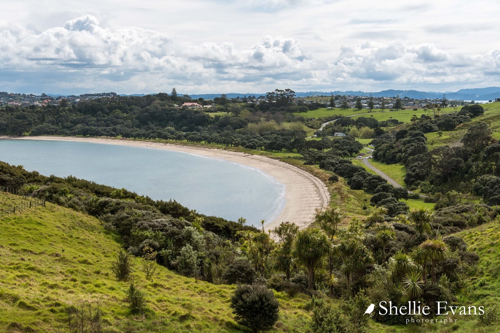
This is the stunning Shakespear Open Sanctuary, a 500ha Auckland Regional Park that was once a large farm at the end of the peninsula.


This is a ideal site for a sanctuary, a relatively short 1.7km predator proof fence runs across the narrow isthmus between Army Bay on the north side and Okoromai Bay on the south side while water borders the remaining three sides of the sanctuary. You can see the fence snaking down through the gully here on it's way to Okoromai Bay. Gulf Harbour houses overlook the bay.


Mr WH Shakespear purchased the farm in 1883 and built the family homestead overlooking Te Haruhi Bay in 1910, it's now a YMCA Lodge. The farm was purchased from the Shakespear family by the Auckland Regional Authority in 1967. The end of the peninsula was also an important defense site during WWII and the army acquired (and still has) 130ha at the northeastern tip which is fenced off.


The farm woolshed used to sit right in the middle and to the front of Te Haruhi Bay; obviously for ease of shipping sheep and wool from the farm.


The historic woolshed has now been shifted back from the water and sited below the homestead, you can see it mid right in this photo (click to enlarge), the homestead is higher up to the left. Our camping area is on the right side of the road above the cars you can see, You can just see the end of a caravan below one of the trees.


The Auckland Council run a website booking system for all of their 26 regional parks; bookings for camp sites and camping grounds, for accommodation in houses & baches within the parks, for functions inside buildings (such as the woolshed) and outside for picnics & parties at the numerous BBQs that are dotted around the park.

It's quite a long-winded and often confusing website to use but once you get the hang of it, it does work. It just takes a bit of time to organise things, and to get your bearings if you're unfamiliar with the parks and their layout.


We initially wanted to book at the campground (basic) in the park where you can stay for 7 nights, but it was closed because of the ground conditions. This only left us with the CSC (certified self-contained) camping area, which was fine except that there was a maximum of 3 nights only.


Once the booking is confirmed ($15pp per night here) the combination number to the gate into the camping area is sent via email- so you do need to be organised before hand if you're wanting to stay (or risk sitting outside a gate for a couple of hours waiting for confirmations and emails).

There are 4 hard stand areas to park on the side of the drive in the CSC area or you can park on the grass if the ground allows it. We had the place to ourselves the first night and then 2-3 vans for the next two nights. In the end I decided that I liked this area probably better than the other camp which was at the end of the bay.


It wasn't too far to walk across the grass, pass under the large pohutukawa trees lining the sand dunes, to reach the beach.


Where another world can be seen far across the water...

Sky Tower & Auckland CBD
... and Rangitoto Island in another direction. 


The bird life throughout the park is amazing....but more on that in the next blog.

To be continued....


Tuesday, October 4

Beach Hop South- Herbertville & the Pipi Bank

Real-time

Not far from Porangahau and on the way to our next beach destination we pass an iconic NZ tourist attraction, a place that unless you've in the area, is a very long way from nowhere. At 85 characters, this is the longest place name in New Zealand (and some say the world but that is often disputed). It belongs to a small unassuming hill on private farmland and luckily there is a signpost and information panel letting you know you have arrived, otherwise you might just drive straight on past!


I had a couple of goes at pronouncing it and it wasn't actually too hard if I broke it down into syllables or known words- although I'm guessing I didn't break them down or pronounce them correctly, but still I gave it a go. The Maori name translates to "the place where Tamatea, the man with the big knees, who slid, climbed and swallowed mountains, known as 'landeater’, played his flute to his loved one."  Locals simply call it Taumata Hill.


I'd been waiting to visit our next destination since we started the beach hop south. I've never been to Herbertville but I feel like I know it very well. 


Life time family friends of Mum & Dad lived in Herbertville for over 20 years, they owned the hotel and the campground and also had (and still have) a few properties in the village. By all accounts I think the village should have been renamed Sunnexville because according to the current owners of the hotel, the Sunnex family were very instrumental in helping the settlement survive and thrive. 


We met Lorraine & Art Bloom, the current owners, when we stopped in for a coffee. The couple have turned the old hotel into a combined bar, restaurant, cafe & small general store. They also have accommodation available and I have the feeling that their establishment would be a hive of activity over the summer months. 

You might remember the courtesy car from the Patangata Hotel early on in our Beach Hop, well this is Herbertville's version. For real! Apparently as part of the conditions of their liquor license a courtesy car must be available. It all makes sense now, we've seen some rather random and unusual courtesy cars in our travels but I think this one takes the cake! 


Anyway, I'm getting ahead of myself because before we visited the village we drove straight on through and out the other side to the beach, and then followed the gravel road down the coast a few kilometres until we reached Pipi Bank Station- what a cool name for a farm. For my overseas readers, pipi (pronounced pip-ee) is a shellfish that lives deep in the sand along many of NZ's beaches and which can be dug for at low tide. Cooked and eaten in pipi fritters! They are often packed together in dense patches, hence 'Pipi Bank'.


I had called ahead to the Station to ask permission to camp along the foreshore. Permission was granted as long as we didn't mind that the station's cows and calves were grazing the area and we didn't have a dog. I'm afraid no dogs are allowed at any time of the year.


We drove right to the end of the road checking out the numerous suitable camping areas and decided on one not far back up the road after turning around- it was reasonably level, close to the ocean, and had a minimal amount of fresh cow pats. It would seem the cows preferred these areas too.


In the winter we usually park so our slide-out is facing the view, that way we can sit at the table and watch the activity or take in the scenery from the warmth of our van. In the summer we usually have the door facing the view, then we can sit outside drinking (sometimes literally) in the spectacular views and enjoying the summer sun. I can't wait for summer because my bedside window is on the door side and I like to have it open to hear the sound of the ocean waves or a river passing close by.

That is Cape Turnagain, a prominent headland, on the other side of the bay. The cape was named by Captain James Cook in 1769, he sailed south to this point before deciding to turn and head north around New Zealand, hence the name.


And, it's not always the ocean view we see out the window. When you're out in the middle of nowhere it's a surprise to suddenly see a vehicle roaring past. Perfect and purposely fitted out for fishing I'd say. And in fact we later learnt that it was Lorraine & Art from the hotel- they were heading for the rabbit wall to check out the fishing. The rabbit wall is a wall of rocks on the beach which were put there to stop the rabbits from getting through. Though I'm not sure from what direction.


What a fantastic place to stay, we had the whole place to ourselves (well nearly if you don't count the local shepherds and fisher-people tearing by), wild, remote and rugged we both felt immediately at home. I went for a few walks down the beach at low tide.


Once I'd spotted a couple of rooks landing on the beach and I was hoping to catch them off guard by creeping along in the dune grasses, but we all got a fright when I stumbled upon them digging under a log. Rooks are quite common in the Hawkes Bay area but these are the first I've seen on this trip. 


I followed them up the beach for awhile but they always spotted me coming and flew further on. In the end I gave up and just took photos of the beach.


I found a number of mussel nurseries on the large rocks exposed at low tide, some interesting rock formations and the remains of  a vehicle tucked under a sand bank.


I walked home, back along the road...


...passing a few neighbours keeping a wary eye on me along the way.


And in fact every time I stepped outside or went for a walk I felt a hundred eyes following my every move...


I loved this little guy, that's him above trying to hide behind the road marker, he was giving the marker a hard time,  backing off and then running at and butting it as hard as he could. Except of course it kept bending over. It would bounce back and hit him in the face and he'd try again.


I hid behind the ute and he crept up on the van at one stage but then his mother saw me and called him and he raced off, kicking his heels up on the way.


When we returned to the village to check out the hotel, I took a few photos along the way- this is the memorial to the Herberts, early settlers after whom the town is named.  


In the late 1800s/early 1900s Herbertville used to be a thriving community. It had a large hotel, several shops, a police station and a blacksmiths. Schooners were beached on the vast expanse of shallow sandy beach on high tides and passengers and cargo unloaded. The ships would be refloated on the next high tide and carry on up the coast. Horse drawn coaches then made their way towards Dannevirke, 68km away. A memorial stands on the side of the road for past settlers; I think the cemetery is long gone, I couldn't see it anywhere.


The angle is a bit off here, there was a fence in my way, but it's interesting seeing the occupations and ages of past residents. This was just one side of the memorial (remember to click on the photos to enlarge)


The campground is pet friendly and also has 'permanent' sites which at $2500 for unlimited nights, per year, would make an excellent base for those that live on the road fulltime.


I love this bach, I could quite easily own this cutie.


And this old woolshed makes another excellent subject.


On our way home I stopped to take a photo of this grand old lady, the Burnview Station homestead. Burnview Station is just before Pipi Bank along the coast road.


We hadn't lingered in Herbertville as we actually had an appointment to keep- yes, in this most remote place we were due visitors! Lynn & Max have an Ultima 5th-wheeler too and have been following my blogs for a long while. The most amazing thing is that, Lynn had to drive over from Kimbolton in the Manawatu and collect Max who works at Weber and then come on out to Herbertville. They must have been really keen to see us- that is a bloody long way on very winding roads! 


It was great to meet them both, and we were treated to a some lovely goodies too. I didn't think the home-kill lamb chops would have looked quite the part in this shot, but they sure were tasty too.


Before we left the beach we drove to the top of the hill up the road. There's a track that goes all the way to Akitio, the next beach on our list south. Of course we wouldn't tow the 5th-wheeler over this track(although the bit we did cover would have been ok) but we wanted to see if the gate between the Akitio Station and Pipi Bank Station was open- we'd heard people do use the track with permission. The gate had a huge big padlock on it so there was no access to the uninvited today. 

Quintessential New Zealand- cabbage tree, surf beach, farm track, Ford utility (Ok, I put that in there for the Holden lovers). The view back down to the beach.


We had a lovely relaxing time at Pipi Bank but eventually it was time to head onto our next beach. 

Of course there were a couple of stops along the way; this family cemetery which is still being used by the Franklin family.


And a photo stop (only) at another country pub, the Wimbledon Tavern.