Showing posts with label fence. Show all posts

Thursday, September 27

An Open Sanctuary- Part 1; Shakespear Park

Real Time

To try and keep up to date, I'm going to do a few more short posts rather than wait until I have a stack of photos to process and then have to spend a couple of days writing up a long post. We'll see, but you know how it is, it's very hard to change a habit of a lifetime (well 6 years of blog writing anyway).

From Ardmore we carried on heading north towards our next destination...


...timing the drive through Auckland just right as there wasn't too much traffic on the motorways. It's been five years since we last saw the Sky Tower loom up ahead of us. 


Once across the Harbour Bridge and through the northern suburbs we headed out along the Whangaparaoa Peninsula where the locals have this flash (fairly new) control system to ease congestion during rush hour traffic. The middle lane changes direction depending on the traffic flow. Outside rush hour it becomes, as the sign says, a flush median. 

You might wonder why this was of interest to me; we used to have this over the causeway on Chapel Street in Tauranga for a number of years (before the expressway was built). We didn't have flash lights and signs though; ours were just road cones that were moved from one lane to the other during rush hour- it fixed the problem though! 


Twenty kilometres later we arrived at the tip of the peninsula; our next camp is through that pest proof fence. The automatic gates open as we approach; of course we have checked we have no stowaways onboard- you know us and our mouse traps; they are permanently set in the rig.


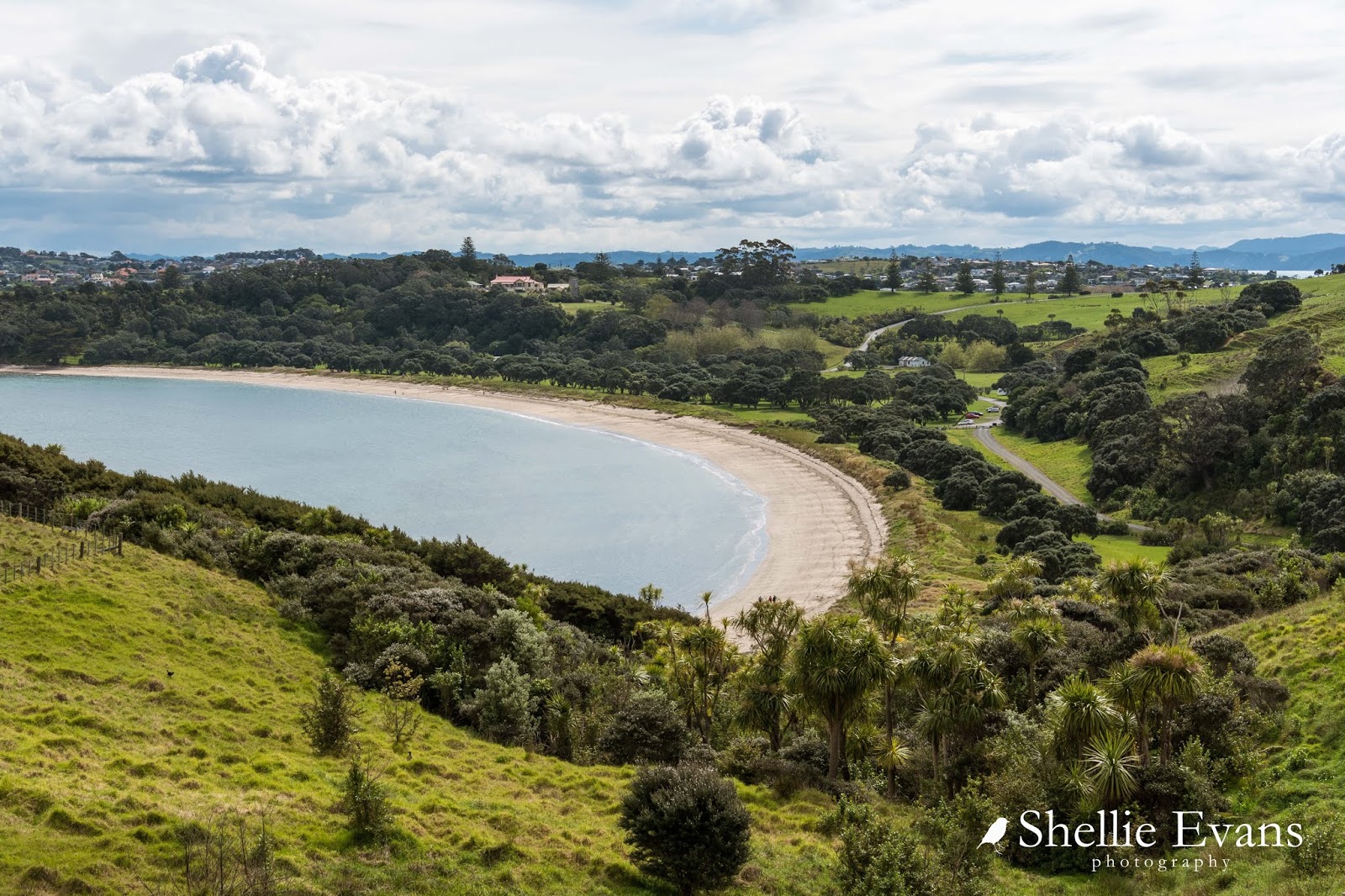
This is the stunning Shakespear Open Sanctuary, a 500ha Auckland Regional Park that was once a large farm at the end of the peninsula.


This is a ideal site for a sanctuary, a relatively short 1.7km predator proof fence runs across the narrow isthmus between Army Bay on the north side and Okoromai Bay on the south side while water borders the remaining three sides of the sanctuary. You can see the fence snaking down through the gully here on it's way to Okoromai Bay. Gulf Harbour houses overlook the bay.


Mr WH Shakespear purchased the farm in 1883 and built the family homestead overlooking Te Haruhi Bay in 1910, it's now a YMCA Lodge. The farm was purchased from the Shakespear family by the Auckland Regional Authority in 1967. The end of the peninsula was also an important defense site during WWII and the army acquired (and still has) 130ha at the northeastern tip which is fenced off.


The farm woolshed used to sit right in the middle and to the front of Te Haruhi Bay; obviously for ease of shipping sheep and wool from the farm.


The historic woolshed has now been shifted back from the water and sited below the homestead, you can see it mid right in this photo (click to enlarge), the homestead is higher up to the left. Our camping area is on the right side of the road above the cars you can see, You can just see the end of a caravan below one of the trees.

The Auckland Council run a website booking system for all of their 26 regional parks; bookings for camp sites and camping grounds, for accommodation in houses & baches within the parks, for functions inside buildings (such as the woolshed) and outside for picnics & parties at the numerous BBQs that are dotted around the park.

It's quite a long-winded and often confusing website to use but once you get the hang of it, it does work. It just takes a bit of time to organise things, and to get your bearings if you're unfamiliar with the parks and their layout.


We initially wanted to book at the campground (basic) in the park where you can stay for 7 nights, but it was closed because of the ground conditions. This only left us with the CSC (certified self-contained) camping area, which was fine except that there was a maximum of 3 nights only.


Once the booking is confirmed ($15pp per night here) the combination number to the gate into the camping area is sent via email- so you do need to be organised before hand if you're wanting to stay (or risk sitting outside a gate for a couple of hours waiting for confirmations and emails).

There are 4 hard stand areas to park on the side of the drive in the CSC area or you can park on the grass if the ground allows it. We had the place to ourselves the first night and then 2-3 vans for the next two nights. In the end I decided that I liked this area probably better than the other camp which was at the end of the bay.


It wasn't too far to walk across the grass, pass under the large pohutukawa trees lining the sand dunes, to reach the beach.


Where another world can be seen far across the water...

Sky Tower & Auckland CBD
... and Rangitoto Island in another direction. 


The bird life throughout the park is amazing....but more on that in the next blog.

To be continued....


Sunday, March 26

Macraes Giants- Otago; Part 1

Real-time

We went looking for giant lizards at Macraes Flat, instead we found a giant bird, a giant mine and a giant collection of pig skins!


We travelled through some new territory on the way to Macraes Flat, following the eastern end of the Otago Rail Trail which finishes (or starts, depending on which way you ride it) in Middlemarch. We stopped at the old Hyde Hotel where many bikers call in at the cafe for refreshments on their way through.


I also took the obligatory church photos (both now decommissioned) and one of the the old school, which is now a cyclists accommodation lodge.


A little further on we turn left and head up onto the rocky plateau ahead of us. We're on a bit of wild goose chase, one I don't hold out much hope in being successful in either. But we have all day ahead of us and nowhere we need to be in a hurry. And we have our home on the back, so we'll stop where and when the fancy takes us. 


We're looking for Grand Skinks and their slightly larger brothers the Otago Skink, they are New Zealand's largest lizard at 300mm (11 inches) long. They are very rare, very endangered and found only in three or four small areas in Otago, including in the Macraes Flat conservation area.


We've only ever seen them at Orokonui Ecosanctuary in Dunedin where they are successfully breeding- that's a young lizard riding on a parent's back with two juveniles on the rock below. The baby is about the size of the usual skinks people see in NZ.


I took these photos also at Orokonui- that's an adult top left and a baby bottom right and look how well camouflaged they are in the bush. You've probably guessed due to the lack of photos from elsewhere that we failed to find any skinks at Macraes Flat. Which actually isn't that surprising considering the fact that, in the end, we ran out of time and didn't even look! 


Here we are crossing the Taieri River for the upteenth time on our travels. This isn't surprising given that the river is 318km long and flows from the upper reaches of the Maniototo Valley, makes a dramatic U turn around the northern end of the Rock & Pillar Range and flows down through the Strath Taieri Valley (where we are) all the way to the ocean.


We've crossed back and forward over the Taieri River numerous times while exploring the Maniototo and Otago, we've been to the top in the Maniototo Valley and seen the Upper Taieri Scroll Plain where the river begins its journey (click to enlarge) and to the bottom, staying at Taieri Mouth not long after we started this journey and everywhere in between.


This beautiful old iron lattice truss bridge over the Taieri was built in 1879.


It was a long, slow and steady haul up onto the plateau where the views back over the valley to the Rock & Pillar Range behind were absolutely stunning. The Rock & Pillars rise to 1450m and are named for the impressive tors along the ridge. 


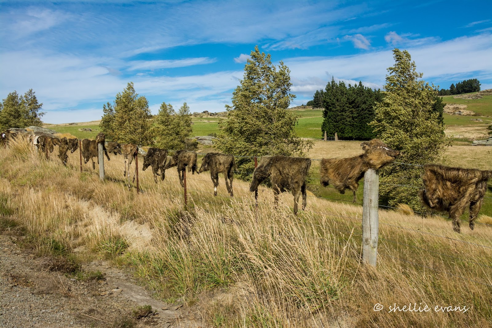
We pass many hundreds of tors on this side of the valley too, in fact we could still be in Central Otago as the landscape is so similar, and then travel on past farmland atop the Taieri Ridge. It took a few moments to register what we were seeing strung along the fenceline ahead of us as we passed here.  As far as the eye could see ahead... 


...and once we stopped, back behind us, at least a kilometre of animal skins! Collected over the past 20 years they are mostly wild pigs but deer, goat and wallaby skins are in there too, some complete with skulls. Eeuw!


There are many bizarre fences in New Zealand; Cadrona's famous bra fence, several shoe fences, a jandal (flip-flop) fence or two, bike fences, hubcap fences, number plate fences but now we've seen it all! No wussy collection here, this is a true Southern Man's fence! 


Further on, and as we drop down into the a huge basin of Macraes Flat, far across the valley we can see some terracing on the hills and steam rising from chimneys near what looks like a very large mine site (I've zoomed in here). I wonder if we'll get close...


Eventually we pull into the old gold mining settlement of Macraes (pop. 54). where there's neither sight nor sound of people about, even though it's a holiday Monday. In 2014 the settlement changed its name from Macraes Flat to Macraes so as to distinguish itself from the surrounding district.


We have lunch parked beside the old stables of the historic Stanley's Hotel (1882) which is across the road.


Stanley's Hotel was owned by Oceana Gold, the gold mining company that runs the nearby mine. In 2015 it was returned to the community in exchange for some impressive artwork....well one piece of impressive art, I'm not so sure about the others.


Located behind where we're parked is the Macrae Heritage & Arts Park and wetland, originally given to the community by the mine it has now been exchanged for the hotel, other heritage buildings, land and money. 


Eventually, I'm sure, the park will be given back to the community. I mean what's a gold mine going to do with a 9m high, 750kg big bird, a tussock planting and numerous large billboards (a very odd contribution if I must say so myself).


The bird on the other hand is a stunning sculpture and such a pity it's not seen by many people. You could drive straight through Macraes and not spot it, or even visit the settlement and not know of it tucked out the back.

With a 12m wingspan, it is of the long extinct Haast's Eagle, a bird that in reality weighed about 15kgs and had a wingspan of 3 metres. It was known to attack and eat moa, the sculpture is in attack mode here. As befitting a bird of this size the eagle was flown, beneath a helicopter, from sculptor Mark Hill's (son of jeweller Michael Hill) home in Arrowtown to Macraes in 2008. Now that would have been an impressive sight. 


This little dog's grave stone and plaque has been moved to near the entrance to the walkway around the wetland and sculpture park. What a sad little poem; David & I couldn't decide whether the driver ran back and forth over the dog until she died or just ran over her and killed her outright. Either way it was obviously a very traumatic time for her owner, and just before Christmas too.


I took a quick walk up the road to locate the local church, and as with many of NZ's abandoned or nearly abandoned country settlements, this is another church that has seen better days. This is the former St Patrick's Catholic Church, a Category 2 listed Historic Place building, now located in a horse paddock and in a sad state of disrepair.


To be continued... Part 2


Saturday, April 6

Stony Bay & Finishing the Coastal Walk

We had one more bit of exploring before we leave the tip of the peninsula; Port Charles & Stony Bay. Both of these along with Sandy Bay are located on the eastern side of the tip and to get to them we crossed over the range just north of Colville and then turned left at the only intersection for miles, turning right would have taken us back past Waikawau Bay and on to Kennedy Bay which then loops back to Coromandel township. We were going to do this road if we had of stayed at Waikawau  before heading south but we’ve heard it’s very corrugated & extremely winding towards the end & as we're not stopping at Waikawau, it now makes sense to head back to Coromandel township the way we came up, on the western side. 


Part of a "Shoe Fence" at the beginning of the climb over to Port Charles
It was only about 14kms from the intersection to Stony Bay but it might as well have been 44kms, Port Jackson’s road had nothing on this one for winding. After 5 kms & 150 corners I lost count & at least every 3rd or 4th one of those was a sharp blind one. The road winds itself through beautiful native bush that covers most of this side of the peninsula. This is the Moehau Range, it forms the backbone of the upper Coromandel Peninsula but runs steeply down to the coastline on this side. Mt Moehau at 892metres, is the highest peak on the peninsula & is of special significance to Maori.

 
Port Charles is the first of only two settlement we come across, population 150,  it’s located on the edge of a large enclosed deep harbour & it would seem fishing is the main activity here. There is also a large mussel farm at the entrance.

The road, which is not council maintained- got narrower & no less winding from Port Charles. A along the way there were tantalising glimpses of the rugged coastline. Finally we dropped down into Stony Bay & the end of the road.


A gate opened into the DOC campground and the other end of the Coromandel Walkway which we had half completed the other day from the other end- (read about it here)

Stony Bay, as the name implies is a beach of pebbles & boulders, very beautiful & surrounded with magnificent pohutukawas festooned with huge astelia epiphytes.
 
We had brought our tramping gear but hadn’t quite decided whether we’d do the walk or not but once we got there and saw that the track disappeared up the side of the hill & into the bush, a totally different scene than the other end, we decided we’d do it now that we were here. We’d walk to the lookout which was one steep climb away from Poley Bay, where we’d ended up coming in from the other side. We could now say we had walked the 7km track apart from that small section. In fact we’ve walked nearly double the distance considering we had to retrace our steps twice.
One of the large pohutukawa that line Stony Bay
It was overcast & rather grey but there were signs that the sun was going to break through, either way; rain or hot,  it didn’t matter as we were under the bush canopy most of the way. It certainly was beautiful, the path was lined with brilliant green ferns, pongas, mamakus and dozens of nikau palm. Some areas were certainly very tropical looking especially when the track crossed one of the numerous waterfalls. The path ran around the steep slopes that fell from the range above down to the rocky coast below, it weaved in and out of the valleys between each vertical ridge and & each turn back out to the ridge edge there was a waterfall. Although with no significant rain for months the falls were more of a trickle. It would be very magical after heavy rain & a little more difficult to cross I would think.
 
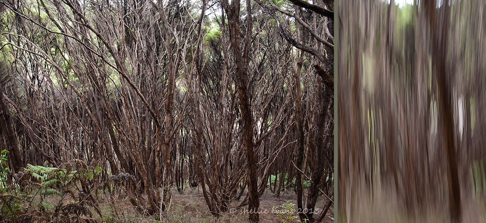
For quite a distance the track also passed through a manuka (tea tree) forest which was the highlight for me. It’s the first time I’ve seen such tall manuka, it’s usually shorter scrub but these were very tall and under the canopy were masses of relatively straight narrow trunks & branches.  On the ground grew bright green ferns which contrasted against the brown of the trunks. Looking down the steep slopes at the mass of branches gave me a touch of vertigo. I did some of my camera tricks too J
 
 
Throughout the bush and in fact all along the roadside are bright marker pointers written in various codes. These mark areas where there are pest traps or bait stations set. As most of this area is conservation land & many kiwi reside & have been released here, DOC obviously have an intensive pest eradication programme running.
That's NZ Mistletoe on the trunk
Two hours, 4.8kms and many tantalising views of the coastline & secluded bays later we finally reached the fork that led to the look out.
Centre photo- Mt Moehau
After a steep scramble up a slippery clay track we were greeted with fabulous views up & down the coast and out to Great Barrier Island. And there not very far away were the Pinnacles which were the prominent point of interest when we came in from the other end.
 
Port Charles harbour entrance is back centre

The track winds it's way back & forward over these ridges. Stony Bay is around the last point over by the green patches
We ate our lunch perched precariously on the side of the cliff. David also rescued a small stick insect that was being harassed by a wasp and then we were off again back to Stony Bay.  

It was a quicker trip back, our legs were starting to tire & by the time we reached the ute we were totally exhausted, we’d done nearly 10kms & shaved an hour of the return leg. I know this because David has an app on his phone called “My Track”, which keeps all the data. I have a few photos of him standing on various tracks looking at his cellphone. I kept thinking what’s he doing checking his phone so often. I’m thinking he’s looking for that elusive cell phone reception but he’s not, he’s checking the data. That is so typically my husband, I said he was a train-spotter ;)

We stopped in Sandy Bay just before the hill over to Port Charles for a well deserved coffee before heading home back over that winding road again. And with that we have done the northern tip of the Coromandel. We’ve got quite attached to this area & will be sad to leave.
Sandy Bay Baches