While David recuperated from his bout of shingles I took myself off on several tiki-tours around Northland, the first one on a several squiggly loops to check out a number of churches and historic places in the wider Waimate North area. Northland has a multitude of small & historic churches and I was keen to add a few more to my church photo collection.

My first stop was on SH1 just south of Ohaeawai, at the historic Pakaraka Anglican Church of the Holy Trinity and probably one of the most visited & photographed churches in Northland due to it's location on the main highway.

The church is Gothic Revival in style and the slim steeple is a replica of the original tower which blew down in a storm in 1946. The new steeple was erected in 2001, 55 years later. The Reverend Henry Williams, one of the first Anglican missionaries stationed in the Bay of Islands and later Archdeacon of Waimate, is buried in the cemetery.

The next church is located on a back street, not far along the road at Ohaeawai, which is a small settlement at the junction of SH1 & SH12. I believe this is an Anglican church but I could find no other reference to it and it's obviously taken a back seat to several other more historic & prominent churches in the area. Like many of the churches around New Zealand, this one is sadly heading to a state of disrepair...

...unlike the nearby Ohaeawai Hotel (locally know as The Crossroads) which looks to have recently had a fresh lick of paint. I bet this grand old lady could tell a few stories if only the walls could talk.

My next stop is at Te Waimate Mission where the remains of a model English village, built by missionaries is located. The Mission House, built in 1832, is the only survivor of three mission houses built in 1830 on behalf of the Church Missionary Society by the Reverend Samuel Marsden (click photo to enlarge)

The Mission House is also New Zealand's second oldest building. I felt a bit mean about not going inside to check it out; I was in a bit of a hurry. And especially as I was the only visitor in the grounds and the volunteer guide came outside to greet me. I had to tell him I was on a mission (no pun intended!)

Te Waimate was New Zealand's first farm and had a very famous visitor; scientist & evolutionist Charles Darwin stayed here for the Christmas of 1835.

Nearby and part of the mission station is St John the Baptist Church which was originally built in 1839 and then rebuilt in 1870 using materials from the first church. the new church was much smaller due to the drop in congregation numbers.

Located between the Mission House & the church is the Sunday School building, built in 1880

Not far down the road, and part of the original mission settlement are the remains of Bedggood Cottage & the Blacksmiths Shop.

The Blacksmiths shop collapsed in 1979 and was reconstructed in 1986 using the original building's materials.

From the mission I next headed to the historic St Michael's Anglican Church at Ngawha.

St Michaels Church was built in 1871 and is located on the site of Pene Taui's Pa, which is where Te Ruki Kawiti successfully defended the Pa against British forces in what is known as the Battle of Ohaeawai. It was built by local Maori as a symbol of peace and a tribute to Pakeha who had died in the battle.
On 1 July, 1845, almost 600 troops and 300 warriors of Tāmati Wāka Nene besieged about 100 men at a pā at Ōhaeawai led by Lieutenant Colonel Despard. Te Ruki Kawiti held off the attack on the highly intricate and fortified pā of Ngāti Rangi chief Pene Taui. The fortifications were ground-breaking in every way, and became one of the prototypes for gunfighter warfare in later engagements.
The pā had two palisades - including a strong inner fence made of puriri logs set almost two metres into the ground with five metres of log standing above ground. The solid palisades of the inner fence had withstood the artillery attack and remained intact, preventing the British from entering the pā. Meanwhile, the firing trenches proved devastatingly effective against the attackers. "Within seven minutes of the attack beginning, over 47 of the attackers lay dead with about 70 more injured. The attack was an unmitigated disaster."
By 8 July, the pā was found to have been abandoned and the defenders had disappeared into the night. Lieutenant Colonel Despard suffered a defeat. (extract from RNZ)

From St Michaels I headed down the highway towards Kaikohe, stopping to check out the Kaikohe Showgrounds & Equestrian Centre which is a NZMCA CAP (costs apply parking). It's where I thought we'd stop for our first night once David was ready to move and we'd left our friends in Kerikeri. It's a great site, well maintained and with lots of space. There's even a couple of sites with power.

The Showgrounds are on the corner of the road that leads to Ngawha Hot Springs so I drove off to take a look; I do love it when I'm on my own and I can pick & choose what to visit & where to stop. Poor David does get dragged down a few too many roads, it's nice not to feel guilty about it today.
Ngawha Pools- there are 16 of them- are fed by a natural geothermal spring and come in a range of temperatures including the 50 degree Bulldog pool which was closed (for obvious reasons!).
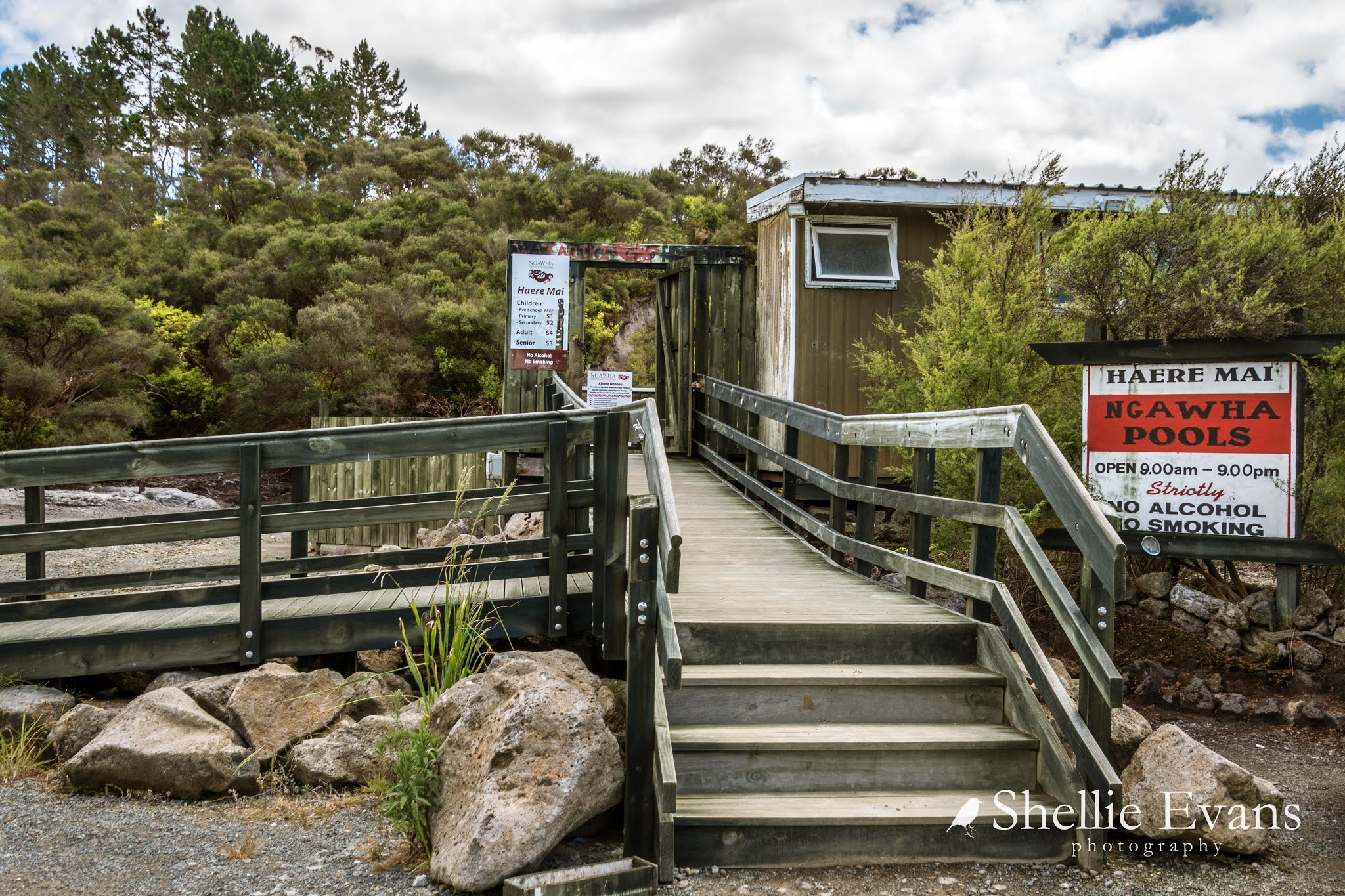
The Ngawha Pools will never look like this again, they are going through a major redevelopment and enhancement programme at the moment and have been closed from March 2020 until December 2020. Obviously the redevelopment was needed, the pools are very popular amongst both local & overseas tourists but it's a shame the unique character of the pools will be lost to flashy frontages and further health & safety features.

From Ngawha I drove into Kaikohe and up to the top of Monument Hill where there are great views out out over the surrounding farmland and from where I spotted the second to last church on my visit list today.

Monument Hill is named after the memorial that celebrates Hone Heke Ngapua who was the grandnephew of the war leader Hone Heke. Hone Heke(the warrior) retired & died in Kaikohe in 1850.

Hone Heke Ngapua (grandnephew) was a member of parliament & active supporter of the Maori parliamentary movement known as Kotahitanga (click on the photo to read)

 |
| Hone Heke Ngapua Memorial |
I drove down and along the highway to the Aperahama (Anglican) Church which was opened in 1885, the church I'd seen from Monument Hill. The church belongs to the Ngati Tautahi hapu (hapu= a division of a Maori tribe) & is essentially a Maori church although European families belonged to the congregation for many years.

The church was restored & repainted in 1964 and is not only significant because of it's age but also because of its association with the development of the Maori Anglican faith.


Information panels across the road from the church tell about the first battle in 1845 of the Northern Wars and the memorial in the cemetery to the 12 fallen British soldiers. The Twin Coast Cycle Trail passes the church which is just as well as these information panels often provide a lot more information than what can be found on the 'net, especially history on the lesser known churches and historic places.

I know I missed a few other churches on my road trip, and in particular the Catholic church just up the road from this St Catherines. I had marked down as many as I could but it was quite hard locating them once I was on the road. Especially when much of the area was out of range to Mr Google when I went to check!
I told myself that I had to leave some for our next visit to the north. From Okaihau, I took the most direct route back to Kerikeri. And didn't spare the horses, it had been a long day.


