Showing posts with label jetty. Show all posts

Tuesday, April 6

Waikawa & Cathedral Caves- Catlins

 Catch-up

Our next camp on our whistle-stop tour through the Catlins was at the NZMCA Park at Waikawa just a few kilometres from Curio Bay. 

Curio Bay & the Petrified Forest

I have tried several times over the years to catch a good sunrise from Curio Bay and just as I've done in the past, I was out the gate early and up at the lookout platform well before sun up. The cloud cover didn't look promising but you never can tell what it'll do and Murphy's Law suggests that if you don't drag your butt out of bed, it'll be the most magnificent sunrise you'd have seen in weeks. 

So there I was in pre-dawn gloom patiently waiting as the cloud slowly thickened up overhead and when I finally saw a golden glow appear on the horizon I sighed in disappointment, one more Catlins sunrise covered in cloud. Although once I processed the photos they didn't look too bad. And it was my only chance, the next two days were grey & overcast.

I drove over to the Curio Bay/Porpoise Bay Headland lookout afterwards & took a few more photos as the sun rose steadily behind the cloud cover. I didn't spend too much time there though as I wanted to see if there were any Hoiho/Yellow-eyed Penguins heading out to sea for the day. I've had several fantastic encounters with Hoiho in both bays but, although I heard them calling, none made an appearance this morning.


On the way back to camp, I stopped near the middle of Porpoise Bay to check for any Hector Dolphins in the wave line. All I found this time were several Red-billed gulls doing their morning ablutions in the stream. 


So with no luck on the bird & mammal front I hunted out some inanimate subjects; the jetty at Waikawa Wharf...


...and the old boat shed.


I made one more stop on the main road as I was heading home. To take a photo looking across the Waikawa River to the NZMCA Camp. This end of the river is very popular for whitebaiting, the old caravan on the slope below the park is a fisherman's hut.  


The NZMCA Park hasn't changed too much since our first visit 7-8 years ago; the front section has been graveled to cater for the ever increasing membership and parking sites are marked out on the perimeter fence (both of these my top two per hates about our parks!). I couldn't get over how much the planted native bush had grown, you could very nearly get lost in there. And the best thing? Technology had finally come to the park courtesy of a nearby cell tower. We had no problem getting internet reception this visit. 


We headed back to Curio Bay late one afternoon picking up Fish 'n Chips from the iconic Blue Cod Caravan in the village. Unfortunately it was frozen blue cod, not fresh as I was hoping, but tasty nonetheless.  


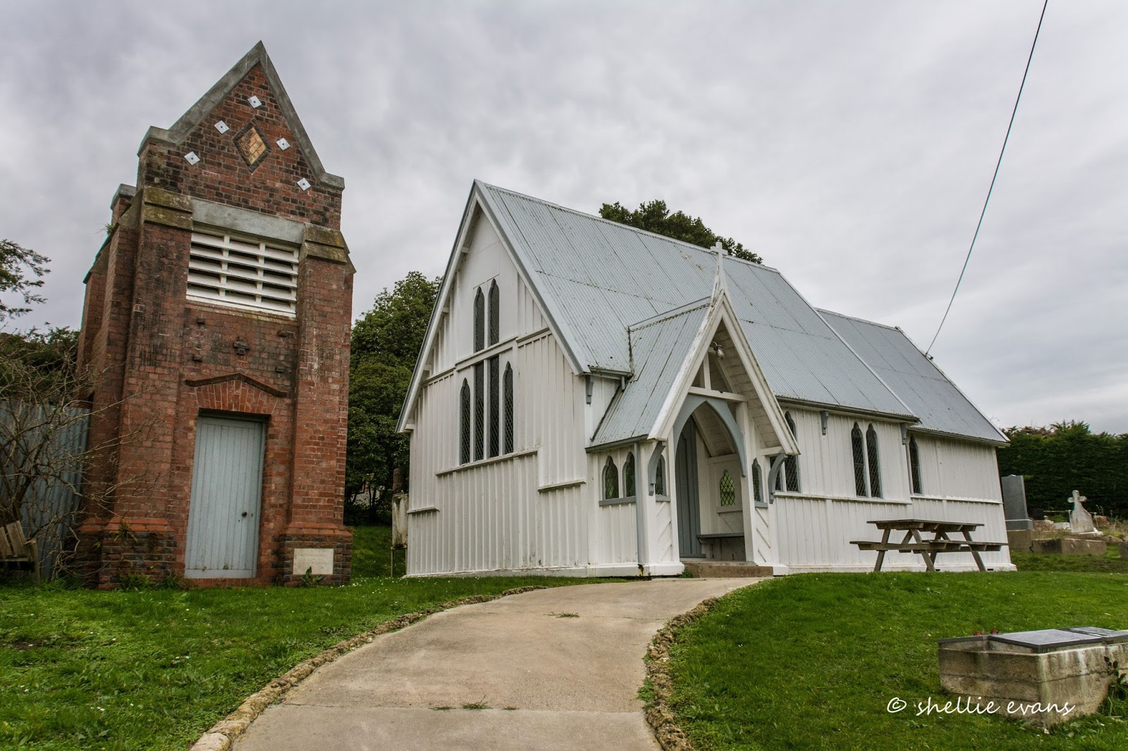
While we waited for our order I took more photos of St Mary's Anglican Church which is opposite the caravan. I do already have photos of this church but you never know the weather could be better in this shot so I always take the opportunity of adding to my pile of church photos.


It was a lovely summer's afternoon with a lot of visitors & swimmers making the most of the waves in Porpoise Bay.


On the other side of the headland we sat on the edge of the cliff above Curio Bay & ate our fish and chips as the waves surged in and out over the rocky platform far below.


It's quite mesmerising watching the waves come & go; crashing over the rocks and spreading out in a large white frothy fans, straightening out the long tangles of bull kelp and then dragging it all back over the edge shortly afterwards. Only for it to be repeated again on the next surge.


Access to the headland between the bays is through the Curio Bay Campground, where many of the sites are tucked into clearings between thick rows of large flax. There are a handful of small sites right...


...on the edge of a small cliff overlooking Curio Bay. It's a fab site with fantastic views but I wonder how many wake in the middle of the night wondering where the heck they are and then when they remember, wondering how safe they are as they hear waves crashing in on high tide just below their vans. 


We drove to the other end of Curio Bay, to where I had come for the sunrise shot, to check if there might be any Hoiho coming home with dinner for their chicks. 


Again, we'd seen several penguins crossing the Petrified Forest platform on one of our previous visits and while we could see the guano on several of the rocky ledges, no penguins made an appearance this time, either arriving home or chicks checking for their parents return. It was going to be no Yellow-eyed Penguins for me on this visit, I hope it was just the timing and not another worrying sign of their steady decline.


From Waikawa we also did a 30km trip up the coast to visit the Cathedral Caves again. We were going to pass the caves the next day as we moved further north, but it was easier leaving the 5th-wheeler parked up at the Park than tow it into the Caves carpark. 


The carpark is at the end of a 2km narrow single lane gravel track through native bush where it's just about impossible to pass if you meet a vehicle coming in the opposite direction. Having said that we were surprised to see a 5th-wheeler in the car park when we got back from the walk. Sometimes ignorance is bliss.


The Cathedral Caves are open two hours before low tide & one hour after so plan well in advance if  you are wanting to visit. You can check their website for opening hours & tide times (keep in mind that internet & cell phone reception is very patchy in the Catlins). The gate is firmly shut outside open hours. 


There's a 1km walk downhill to the beach through lovely native bush...


...and then along the beach to the caves, so a reasonable fitness is required (especially for the slog back up hill afterwards). Although check this photo out! One of our neighbours at the camp made it to the caves with the help of her Zimmer frame and a very patient husband who helped push it through the sand once they were on the beach. 


Cathedral Caves are located in cliffs at the northern end of Waipati Beach, a beautiful long golden sand beach. The two sea-formed caves, whose entrances are 40 metres apart are joined at the rear and measure about 200metres in length in total. They are up to 30 metres in height.


Over tens of thousands of years, crashing waves have gouged out the cliffs of 160 million year old sandstone. Near vertical fractures in the sandstone provided weak points for the waves to slowly dismantle the sandstone faces. Over time the overhanging rocks collapsed creating the caves we see today.


On this visit we were able to get around the point of the cliffs in between the waves and onto the next beach. This was the first time this area had been accessible for a few weeks due to the rough sea conditions according to the lady looking after the carpark & ticket hut. It was obviously going by the kelp attached to the bottom of the cliffs how much time the rock wall spent under water.


Knowing that we had walked around the point as the tide was still dropping, we walked right to the far end of the beach and back.


It was a bit disconcerting to see people still rounding the point and heading off up the beach when we were jumping waves to get back to the caves on our way back. 

We spent a bit of time checking out the few rock pools, some stranded on small platforms a few meters up off the ground. This hermit crab had a very old and unusual shell that looked have had a tough life with the gaps between the ridges worn down to leave spikes. I wonder how many habitants it had had over the years. We placed this one back in his crystal clear pool, hidden under a ledge, as there were a few people  also checking out the pools and we'd disturbed him enough. 


And then it was time to head back along the beach followed by the slow haul back up the path to the carpark. 


We had one more stop for the day, back down the main road a little way and up a side road to one of the many fabulous waterfalls in the Catlins; McLean Falls. The road in is gravel with a downhill section and sharp corner towards the end above the large carpark. 

It was pleasing to see that this section was being widened and the sharp corner cut off to allow bigger vehicles to easily drive in. You can tow your caravans & 5th-wheelers in there now without worrying about getting back out. We found out from the stop/go guy that quite a number of tour buses had been having issues climbing back up the hill around the sharp corner.


One thing I remember vividly of the falls on our first visit to the Catlins- which was also one of first areas we visited when we came to the South Island (and not long after we hit the road fulltime)- was the luxuriant & intense green ferns & mosses that carpeted the forest floor and draped off every available branch overhead as we walked to the falls.    


I can confirm that nothing has changed. The walk & the falls were just as I remembered them, none of the gloss had diminished even though I've now seen & photographed many, many more waterfalls & bush walks.

McLean Falls, Catlins

And with not many tourists visiting I had to be quick to capture this shot with some people in it to give the falls some perspective. You can also see why photographers enjoy slow shutter speeds when shooting water.


Friday, September 8

Port Hills- Dyers Pass and Gebbies Pass

Catch-up 

Before we left Christchurch I managed to do a quick tour over the Port Hills through Dyers Pass to Governors Bay and then back to Weddons via Gebbies Pass, roads we hadn't explored on any of our previous visits to the city. I was waiting for a fine day, but in the end I had to do it on another not-so-great day similar to the one I had when I explored Godley Head at the other end of the hills.

First stop was at the very busy Sign of the Kiwi cafe, an iconic Christchurch landmark; built in 1916-17 as a staging post and opening as a tearoom and rest house. The cafe was closed after the 2011 earthquake and didn't open again until January this year. Just a month later it came very close to being destroyed in the massive Port Hills fire.


I drove along the Summit Road and up to the top of Sugarloaf where another iconic Christchurch symbol is located; the radio & television communications tower.


From there the views are expansive out over the city, across the Canterbury Plains to the Southern Alps behind. In the foreground the regenerating hillside is slowly recovering after the devastating February fires raged out of control and burnt over 1650 hectares of the Port Hills. The Sign of the Kiwi is located just out of sight to the left, where the two sections of the Summit Road meet (click to enlarge).


Parts of the badly damaged Adventure Park including the chairlift can been seen across the valley.


The dead pine trees are slowly being removed.


The fires were ferocious and burned on both sides of Dyers Pass Road and also jumped the Summit road below and burnt up to where I'm standing.


Here's a photo taken during the fire from below, Sugarloaf and the communication tower can be seen at the back, on the left.


I carried on a short way past Sugarloaf until Governors Bay came into view down the inside of the Port Hills rim. I'm heading to the other side of that first finger of land and crossing over Gebbies Pass at the lowest point of the hills behind.


I then returned to Dyers Pass and drove down to Governors Bay, stopping to take a photo of the Governors Bay Jetty (see it in the photo above?) which looks a similar length to the well known Tolaga Bay wharf, north of Gisborne. It was closed and in need of repair; a noticeable section in the middle sagging into the tide.


Next stop was the historic St Cuthbert's Church which was built in 1860. 


It was extensively damaged in the September 2010 earthquake and had only just reopened after a major rebuild.


With the temperature dropping and the day not getting any brighter it was just a few quick stops at places of interest as I wound my way along the very tight and winding roads that follow along the edge of Governors Bay...


...until I reached the old Blacksmith building on the corner of Gebbies Pass Road where I turned inland... 


...and found two more churches to add to my collection- St Peters Anglican Church at Teddington...


...and the Anglican Church of the Epiphany in Gebbies Valley, which must have one of the most elaborate belfries in all of New Zealand's country churches.


And then it was home to Weedons, to pack and prepare to move on out.


Wednesday, July 6

Kaikoura to Winter Warmth

Real-time

With fine weather forecast for the next couple of days we left Kaikoura heading for one of our favourite spots, the DOC Campground at Marfells Beach. Over summer it's usually a toss up between Marfells and Ward Beach which isn't too far away. But over winter when the sun drops behind the hill early at Ward Beach the choice is a lot easier....unless it's blowing a gale. But then neither sites would be very nice.


Being the weekend, there were a few other like minder people already set up on the front row sites.


This didn't worry us as our favoured site is right at the end of the camping ground, which is a long thin area between the road and the beach. 


Except that our spot was fenced off so we went and made a mess in the next section. Actually we didn't but somebody had made a bit of a mess in the mud behind us.

Our site doesn't have any shelter shrubs so if the wind does get up we can get a bit of a battering. We were staying hitched up this time, so it would have been no issue to move if the wind did arrive.


It was great to be beside the ocean again, and lovely to have such warm weather; it almost felt like summer. Sunrise the next morning was beautiful as it rose up behind Cape Palliser across the Strait providing us with a silhouetted view of the North Island, our first sight in a quite a few months.


While I was taking my sunrise photos, a large dog came bounding up the beach barking it's head off at me, like this was her patch and what the hell was I doing in it. Her owner had slept in his car in the boat trailer carpark and we'd seen the dog wandering about the evening before. 

Being a DOC camp, dogs are banned, but once again there are people out there that choose to ignore the rules. I thumped my hand on the picnic table and told her to 'get home' in my gruffest voice. She did turn around but when I next looked she was making her way up a nearby track towards me. I made a hasty retreat inside.


Sunday morning in the fast lane.


There's also a couple of camping areas behind the front row and up on a rise overlooking the beach. It's here that I found Judy & Len who had already stopped by to say hello. They've been following my blog for awhile and got a surprise to see us arrive. It was lovely to meet you both and I hope you enjoyed Ward Beach.


I usually walk east along the beach to Mussel Point from where you can see Cape Campbell and lighthouse in the distance, but the first morning I walked west. There's a large jetty sticking out into Clifford Bay off in the distance and I've been meaning to walk to it everytime we've stopped at Marfells. It was such a lovely day I decided today was the day. 

You can certainly see where the prevailing wind comes from here on the bluff above the road, just before the camp. Part of these clay cliffs came down onto the road, closing it for a number of days, during the August, 2013 Seddon earthquake. There was a 4.3 magnitude earthquake near Seddon while we were at Marfells this time- we were walking on the beach and never felt it luckily.


I knew it was going to be quite a walk even though the jetty looked to be closer than it was. It turned out to be just over 3kms one way. Usually that wouldn't be a problem, but unfortunately I'd left my run too late and the tide was about 2/3rds of the way in. The nice firm sand I started walking on soon turned to 'very hard to walk on' soft, sinking sand as the tide pushed me up the beach. It was hard going.

Beach shelter
Half way along I made my way up into the dunes and found a 4WD track which was a tiny bit easier to walk along. And then that ran onto a firm farm track which followed the fence-line along the back of the dunes. Lake Grassmere and Dominion Salt's, salt ponds are on the other side of the fence. The ponds aren't the gorgeous pink colour that they are in late spring and early summer when the algae blooms. The link above is to a blog I did on the ponds and Marfells when we first visited the area over two years ago.


I knew I was getting close to the jetty when I popped up near this cool Land Rover. I'd seen it atop the dunes from way back. A guy was teaching his partner to surf cast.


It was then just a short walk to the jetty where another fisherman was trying his luck off the end of the structure. This is the old Dominion Salt Works jetty and it looks rather out of place, high and dry and stuck on a beach in the middle of a very large bay.


Clifford Bay was where the Government was looking at sending the Cook Strait ferries, shifting the terminal from Picton to the bay. Perhaps 'the powers that be' were thinking of using the jetty as part of the ferry terminal! 


Photos taken (another jetty to add to my bridge/jetty collection), it's time to retrace my steps. This time, all the way along the fence-line back to the road. The Land Rover was still in the dunes.


The only other people I saw on the walk were these two on their horses out for a lovely Sunday afternoon trek.


I found their vehicle back on the road. I'm not sure whether they stayed overnight but what a great way to see the countryside. A float to transport your steeds and a campervan to meet your needs. 


The sunset was stunning, a warm golden glow bathing the bay and silhouetting the Norfolk Pines in camp. It also highlighted how much salt spray was in the air.


The next morning I walked to Mussel Point (you can see the point in the breakfast photo) just a short 1.5km away but making sure I had plenty of firm sand this time!

Looking back towards camp
Along the way I spied this White-faced Heron/Matuku checking out clumps of seaweed...


...and a hundred or so Red-billed Gulls/Tarapunga squawking and squabbling as they sorted through a large patch of exposed seaweed. 


By the time I reached Mussel Point, the tide was on its way back in. There are good sized mussels on the rocks near the back, David has managed to get a good few when we've visited during the summer.


Further on from the point, the bay sweeps around to Cape Campbell and the prominent lighthouse on it's point.


That walk is also on my 'to-do list' but it'll have to wait until summer, it's another 5kms to the Cape and you have to time it right with the tides. The beach is blocked by the tide beneath the bluffs that I've just passed on my way to Mussel Point.


The weather clouded over mid afternoon so we decided to head to Blenheim, just a short distance away. We parked up at our regular stop-over, the Blenheim Racecourse where we have a 'secret' spot to park. It's sheltered and private....except on darts night which happened to be last night (through that door beneath the grandstand!). It's also not so good during winter as it takes awhile for the sun to make an appearance around the front of the grandstand. 


It was lovely to meet two Blenheim couples (separately) who went out of their way to come and say hello to us while we were parked at the racecourse. They follow my blog and belong to a couple of motorhome Facebook pages I contribute to. 

Hi Diane & Roger and Brenda & Robert, many thanks for stopping by and hopefully we'll meet up on the road somewhere in the future- and next time, hopefully, we'll be prepared for visitors!  We had a bit of a late start and I was still in the shower when the first couple came knocking and David was in the shower for the next couple! Such is life on the road. Where there's not much room to hide! 

The sunset that night was spectacular...


I love the way the swirl of the clouds mirrors the sweep of the branches; it's like the tree is painting the colours across the sky.


And today we've shifted again, we're now parked at a NZMCA CAP in Koromiko, which is just a short 8kms from Picton and a 3 hour ferry ride to some winter warmth! Now that was a surprise wasn't it? 

We're heading back to the North Island for a couple of months, to catch up with family and friends. We're a couple of months ahead of our original schedule but decided we'd visit over winter and come back south in early spring when nature will be all bright and breezy and hopefully the weather will be a little more settled. 


See you on the other side.