Well, that was a bit of a long unintended break and now I'm even more behind than I was before. We've been on the move quite a lot recently and it's been a little difficult catching up on photo processing and writing blogs at the same time as we've been 'Out There' exploring and I've been shooting even more photos.
I'll carry on and finish off a couple more blogs from our winter stay at Glendhu Bay, Lake Wanaka during August (which seems so long ago now that summer is on our doorstep) and then perhaps try doing a few blogs long on photos and short on words to catch up.
I had David drop me off at an entry point to the Millennium Track which follows the shoreline of Lake Wanaka from the town centre right around to Glendhu Bay, a distance of about 18kms. I thought the entry near the Roys Peak carpark was about half way but in fact it turned out to be quite a bit more and I ended up walking about 12kms.
 |
| Roys Bay looking back towards Wanaka town with Ruby Island in the centre. |
The entry track I take is off the Mt Aspiring-Glendhu Bay Road and crosses farmland passing by this derelict house (and perfect photographers subject) before reaching the lake.

Once on the track proper the views over the lake are stunning- this is looking towards The Peninsula (on the left), Dublin Bay and the Clutha River outlet.

The track is also an intermediate cycling trail and quite narrow in places so I need to keep a look out for cyclists too. Although I needn't have worried I have the track to myself for most of the way.

Looking up Lake Wanaka past Mou Tapu Island on the left to Mou Waho Island in the distance, this is the island we visited in our boat on a previous stay at Glendhu Bay. Mou Waho Island is famous amongst tourists because it has a quirky point of difference, you can read about it here, in my blog from our visit.

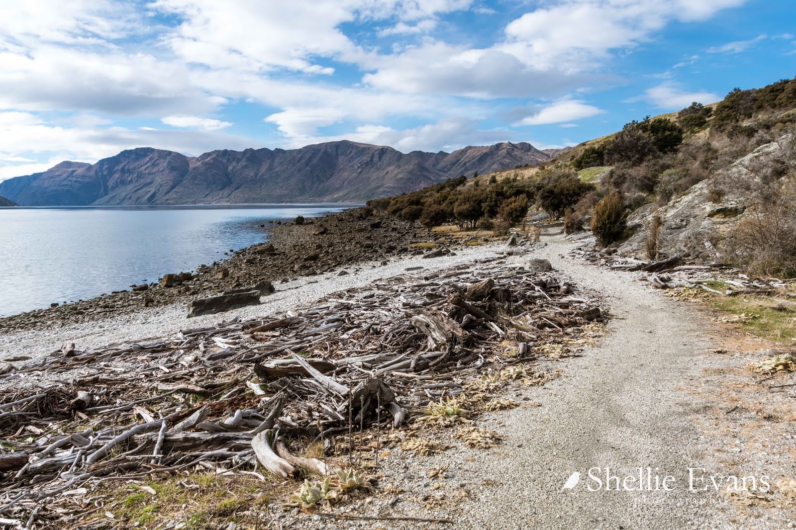
A sign post indicates that a short track down to a gravel beach has something interesting for me to see. When I get there there's just a information panel telling me a little of the history of the previous landowners. Of more interest to me is the driftwood hut someone has built.
A snow covered Roys Peak overlooks the lake and going by the number of cars in the carpark when we passed, there will be quite a few (unequipped) people fighting their way through the white stuff to reach the peak today.

I head back up to the track and as I climb higher, I can see the beach and the driftwood hut below me.


The views open up ahead of me as I round each bend A snow covered Mt Alta forms the backdrop to the western side of Lake Wanaka.

Below me the water is crystal clear and inviting. Some of the small beaches I pass would be ideal places to stop and have a cooling swim in the summer.


The clouds are rolling in over the mountains and I'm hoping I reach Glendhu Bay before a) they obliterate the view to Mt Aspiring, and b) any rain arrives.

Behind me I can now see Ironside's Hill named after the landowner, and the small Wellingtonia Pine atop it. The pine was planted on the summit in 1957 by the owner and is remarkable in that it remains a relatively small tree considering how old it is (the hill is also where Jim Ironside's ashes are scattered).

Around the next bend the perfect lunch spot appears before me; a picnic table on a small point with expansive views over the lake. I hurry down the side track to the table; I'm looking forward to having my lunch and also giving my wary legs a rest.

In the quite stillness I hear a boat coming long before they round the corner and speed across the water in front of me, as they head towards Wanaka.

After a long lunch and short rest I head back up to the main track and there's a little bit of consternation when I round the next corner and see that I still have a long way to walk; I can see the track running along the bottom of the hill on the otherside a large bay. The snow covered mountains behind, which include the Treble Cone Skifield, are the backdrop to Glendhu Bay.

I also see a couple of cyclists heading away from me, they must have passed me as I walked up the lunch track back to the main track.

Damper Bay is a much larger bay and would be a pleasant place to anchor a boat in, have a picnic and a swim. That's part of Roys Peak range up behind.

When I reach the middle of the bay it's obviously that people do spend their summers here, there's an abandoned campsite and a hut in the trees, it's a bit spooky so I don't hang about.

I wonder if this is where the owners of the farm that borders the bay (and friends) have holidayed over the years.

Some of the nearby tree plantings, including fruit trees in blossom (yay, spring is on it's way) indicate that there may have been a large homestead in the bay in days gone by.

Down close, Damper Bay beach is rather rugged with lots of diftwood and 'tide' lines indicating the frequent rise and fall of the lake due to the hydro dam activity on the Clutha River.


And then I spot the two cyclists heading back towards me, they're struggling to get up the slight rise, weaving from side to side as they push on. I wait until they reach me before I move. They stop to talk and I ask if they made it to Glendhu Bay. Yes they did they say. But I suspect, as I had only just seen them heading the other way, they made it around the last corner into the bay and then turned around and headed back. It's still about 3kms from the corner to the camp as I was about to find out.

The woman says she's only just started cycling with her husband and they had been told it was a fairly easy and level track. She was struggling with the climbs and some of the narrow sections along the cliff edges.


...as I finally see what must be the last corner...

...before I'm heading into Glendhu Bay. And unfortunately I can see that Mt Aspiring is being coy again and is hiding behind the clouds.


...until finally I can see Glendhu Bay camp and home across the water. Not too far now but I'm so tired and my legs ache. I call David up to see if he can come and get me when I reach the walkway carpark. I'm not worried about the last kilometre to the camp, I don't need to join the dots this time.

Well, at least that's what I think. David answers his phone and he's in the boat bobbing about over the far side of the bay! There's nothing for it but to continue on. One kilometre feels like three by the time I reach home. I drag myself to the van and can hardly lift my legs to pull by boots off as I sit on the step very weary. It was a awesome but tough 12kms in the middle of winter, especially when my fitness isn't the greatest. All the same it's a great feeling to reach the end. Mission accomplished!

A fews days later I stop at the Mt Aspiring View carpark so I can take a photo of that elusive mountain. It's that tiny peak way at the back on the right, in the V of the mountains in front. It's tiny because it's over 50kms away!

PS-and no that is not me on the rock!
This is why I like Southland so much, you get to see scenery you just can't see anywhere else.
ReplyDeleteYes, around every corner there's a different landscape and a bigger view. The South Island has so much diverse scenery done up in a tidy little package that's easy to explore.
DeleteThat walk is something that we are not fit enough to make, so Thank You Shellie for sharing those fabulous views with everyone.
ReplyDeleteThankyou for your kind words, pleased you enjoyed your virtual walk with me :)
Delete