Showing posts with label Haast beach. Show all posts

Friday, July 1

Curly Tree & Ship Creek Treats

Catch-up

We left Haast Beach Holiday Park after the long weekend and on another stunning day, with thoughts that we'll definitely be back to explore further over the summer months.

We cautiously approached the one way Haast River Bridge, which at 737 metres, is the longest single lane bridge in the Southern Hemisphere. There are two passing bays in the middle of the bridge should we meet anyone coming from the other direction, although with the 5th-wheeler on the back it would have been awkward slotting into them. Luckily we had the bridge to ourselves.


Our first port of call on our road trip north today is the Curly Tree Whitebait Company beside the Waita River. A sign points the way in and we hope we'll be able to turn around once we drive down the gravel track. The track actually leads into Waita's fishing settlement and a farm house and yard beside the river.


 In a shed, alongside the farmhouse, whitebait fritters (they call them patties here) are made and sold, along with whitebait itself, when it's in season or the freezer full. Curly Tree is a popular place and is well known amongst visitors who've read about it on travel websites. 


We've had whitebait from Curly Tree before, when we attended the Bluff Oyster Festival a couple of years ago. When we were all evacuated as a violent storm blew through, and after Curly Tree had driven over a thousand kilometres to get to Bluff- via the Lewis Pass, as Haast and Arthurs were closed due to the weather. This lady remembered it well, it was a disaster for them.

There was a collection of whitebait nets beside the shed, including a large box net which is the one that's fixed beside the  lifting whitebait stands I mentioned in earlier blogs. The fritter was fine (with a little mint sauce drizzled around the edges, another thing I learnt from Curly Tree at Bluff) although I never know what the fuss is about, give me Blue Cod any day.


I walked back along the track and met David at the entrance so I could take photos of the fishing huts. There's no need for burglar alarms or guard dogs here, I walked around a corner to come face to face with a monster bull and 5 of his mates, equally as big. 


I'm sure they are docile enough but I wasn't taking any chances and gave them a wide berth as I made my way to the rig. I figured the closest bull would be held fast for as long as it took me to reach the ute if he did decide to check me out; he was knee deep in a bog.


It's not often that we explore along the road we are travelling with the 5th-wheeler on the back. We usually park up and then radiate out exploring over the next few days, it's easier to get to some places and we don't have to worry about parking. But with alot less traffic on the road over winter most of the car parks and pull-ins can accommodate our size fine. 


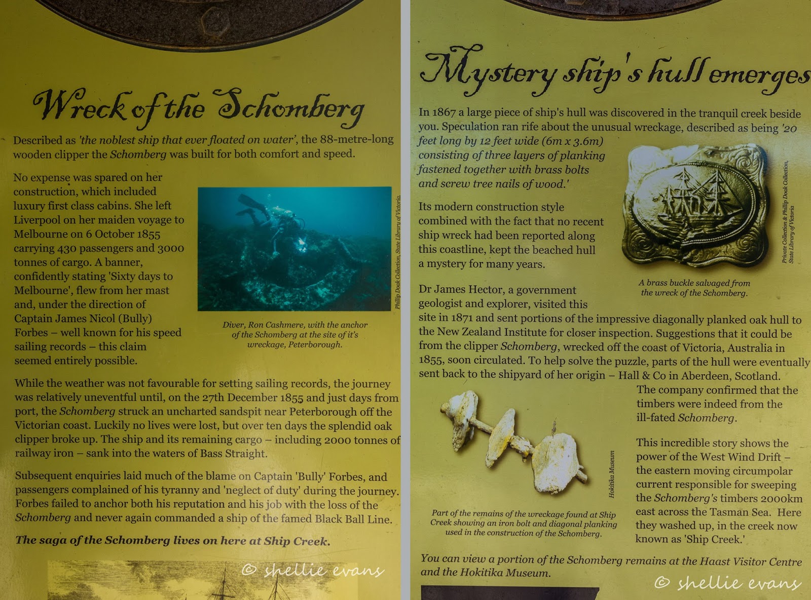
Our next stop is at Ship Creek. This has got to be one of the best short walk activities we've seen and is very well set out by DOC. I know I was impressed with the Hapuka Walk across the road from the Haast Beach campground but this was even better. Two totally different but stunning walks that showcase the many beautiful features of the West Coast's landscape.  A boardwalk leads us to a large shelter with a tower where...


...after climbing up a well fixed, standard aluminium ladder you get a panoramic view along the coast line south-west right around to Jackson Head in the distance, out over the carpark and to the swamp forest behind. 


On the pillar supports of the shelter there are a number of information panels explaining the reason for the Ship Creek name (click on the photo to enlarge). 


We decide to do the 1km, 30 minute Dune Lake Walk first. The boardwalk passes along the back of the dunes and we stop to check out the first of a number of interpretation panels along both walks. One of the reasons we'll be back in the summer is to see the Fiordland Crested Penguins/Tawaki that live on the Coast, they start arriving back in the spring to breed. Did you see the No' Dog' sign back at the carpark? No? Neither did that couple out on the beach! Grrrrr......


We leave the beach behind and follow the track into the bush where it winds its way through dense coastal forest stunted by the prevailing westerly wind, before climbing steps up onto a platform with more magnificent views and explanation panels.


We can now see the dune lake that gives the walk its name. 


I've included the panels again just because I know there are people out there (hi Dad) who like to have all the information. It would take me far too long to research and write my blurb on the subject and I'm in catch-up mode so I must move along! Also, you may not have noticed but the cream fishing crib back at Waita was named "'Drovers Rest' On the cattle track". Now you'll see why.


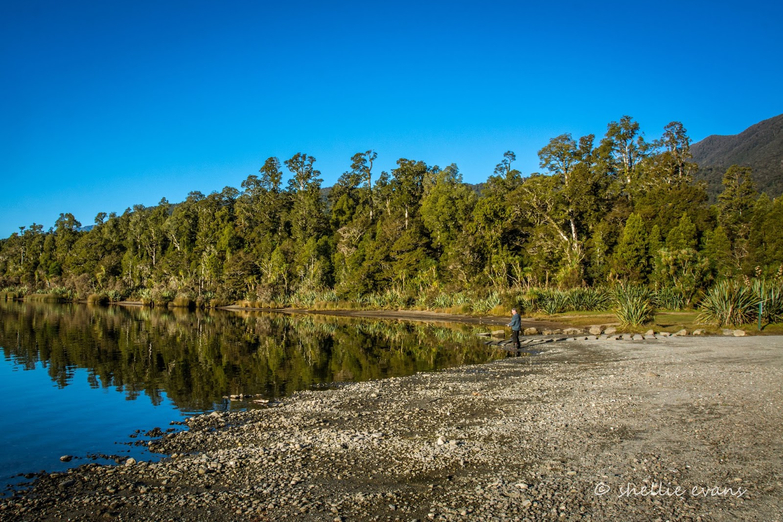
We leave the platform behind and follow the path on through the bush until we reach another boardwalk and the dune lake. There's one lonely Black Swan who makes a hasty retreat towards the reeds when he spots us. We don't see any other waterfowl.


The boardwalk skirts around the edge of the lake and winds up into the bush and up to another platform and more information. It was interesting reading about the water reeds/Kuta I must say, we usually only hear about flax being woven.


From the platform we can look down on the lake and see that there are still no birds in sight and that the black swan is still hiding. Personally I think this lake is a little slice of hidden paradise.


The track heads back towards the carpark and we're now passing through a magnificent emerald green forest, the understory draped in ferns, mosses and epiphytes. This is what a rain forest is all about. Small birds flit about, dart across the path or call from the canopy.


We pass back through the shelter and out to the other side heading for the second shorter Kahikatea Swamp Forest Walk, a 20 minute 800 metre walk.


The gravel track is wide and passes under the road bridge tracking up the side of Ship Creek whose dark tannin stained waters lay still and reflective. The path turns inland and becomes a winding boardwalk over the top of a dark soup-like swamp. Once again the forest trees are smothered in epiphytes and mosses. These are a few of the remaining Kahikatea (White Pine) left behind by pioneers of past.


We come to another platform deep within the swamp, with, what looks like a couple of large round crates as tables and one that someone has put on it's side. It's a wonder they haven't been thrown into the swamp, we think. Except that they are all fixed to the decking and don't move.


These are cheese crates made from the Kahikatea trees that were milled from the forests along the Coast. Back in 1769 Captain Cook thought the tall straight trunks of the Kahikatea would make ideal spars on sailing ships but the wood proved too soft. Settlers soon felled many trees as they drained the swamps, the land was flat and fertile and good for agriculture. Once dairy became established and product exported to England, the great Kahikatea forests came tumbling down, the pale and odorless timber was used for butter boxes and cheese crates to protect the exports.


We made our way around the swamp boardwalk loop and back onto the creek path, passing another deck with an impressive view of a lone Kahikatea standing very tall and alone. And not too far from the base of the mighty tree I spied another familiar sight, two tiny and slightly faded Blue Pinkgill mushrooms, not so rare on the West Coast but rare in the world; New Zealand and India are the only two countries where the blue fungi is found. 


I'd highly recommended both walks if you are travelling along the Coast road, and especially if you are visiting the West Coast for the first time or you have overseas guests with you. 

Our next stop is at Knights Point lookout. Knights Point (named after a road workers dog by the road gang) marks the meeting of the highway- road gangs worked from the south and north on the Coast road and Knights Point is roughly where they made a connection. A stone monument and plaque commemorate the achievement.  

There are more than enough 'love birds' holidaying in New Zealand at this time of the year; couples hand in hand on walks, couples smooching at picnic tables, couples cuddled up for selfies, couples sitting arm in arm on lone rocks looking wistfully out to sea, couples in motorhomes.....wait that's us.   


The lookout was boarded up and access closed and it looked to have been for awhile too. Obviously something's not safe on the overhanging deck. A pity because the views would have been stunning. I managed to take a photo between the greenery. 


We arrived at our overnight stop in the late afternoon. The DOC camp at Lake Paringa is just a short 60kms from our starting point. All those stops and walks have taken us most of the day to cover. That's the beauty of having no plans or itinerary, it's what we love about our life-style. Start and stop whenever and wherever you like.


Unfortunately as lovely as the camp is, the sites are all individually spaced out and set back into the reserve surrounded by bollards and far too small for our rig. There's no one else in the camp tonight so we decide that the best place to park is in the boat ramp carpark. I doubt there'll be an influx of boating traffic this evening.


The afternoon draws to a close and the reflections on the lake are beautiful.


Lake Paringa is a small horseshoe shaped lake with a large hill (or small mountain) at the centre point (out of picture, to the right). It was a shame, the sun sets earlier enough as it is at this time of the year, but it dropped behind the hill even earlier, and not long after we arrived.


Not before David got his spinning rod out and went fishing; having fun with a half a dozen or so small to pan sized trout and salmon. All caught and released of course. 


We woke to thick fog the next morning and a bone chilling cold- another reason we love this laid-back lifestyle, there's no reason to be up and off at the crack of dawn. It took a long while for the sun to even attempt to push through the pea soup...


...and then slowly but surely the mist lifted...


...with just enough blue sky & promise of some warmth for David to try out his luck again. 


More fun with some very sprightly fish and then it was time to hit the road again.


Friday, June 17

On The Edge of the Wilderness - South Westland

Real-time, back to the West Coast!

We based ourselves at the Haast Beach Holiday Park at Okuru so we could explore south to the end of the road (the tarsealed one). It was the long Queens Birthday weekend and as you can see we had brilliant weather.


Right across the road from the campground is the excellent Hapuka Estuary loop walk.


It's just a short 20 minute walk but it has all the features; flax, cabbage trees & kowhai trees around the edge of the estuary, several boardwalks over the wetland, even a small jetty for boats and kayaks, and then the track moves into thick luxuriant rain forest dripping with moss and epiphytes, with a lookout  over the estuary out to the coast. And there are lots of birds. 

This is one of the best short walks we have done and it's well worth the detour if you're passing by Haast township and not in a hurry- better in my opinion than any of the Haast Pass walks. We've added it to our must re-visit list; we'd love to see the kowhai and flax in flower, there would certainly be an overload of feeding birds then.


We headed south towards Jackson Bay passing through the small settlement of Hannahs Clearing along the way.


The road is long and straight and the rain forest forms a tunnel over the top of much of it. The road is also very undulating and the camber keeps pushing us to the side. We decide that this must be to help remove the rain from the road surface and the undulations are caused by the swampy ground underneath. 


We stop at each of the rivers as we pass to check for trout and reflections.This is the Waiatoto River where the water runs still and deep and the reflections are magnificent!


Actually it probably isn't that deep it's just the water is so dark it looks deep.


The Waiatoto River is formed by several small rivers which are fed by glaciers surrounding Mt Aspiring.


And, I'm thrilled to find out that the rivers south of the Haast turnoff are unique in that they have lift-up whitebait jetties. I've seen photos of these jetties but didn't realise there were so many on the rivers down south.


Looking like over-sized giraffes waiting to dip their heads into the water, the jetties stick out over the water at regular intervals along the river bank. They're patiently waiting on their owners return for the whitebait season which begins on September 1st along the Coast. I have some more photos and a separate blog post coming on the stands.


Our next stop is the Arawhata River where the road turns hard right to Jackson Bay or straight ahead onto a very long gravel road that ends about 65kms further south at Cascade/Red Hills deep within the National Park. We won't be heading all that way (although I'd love to do it some day), we'll just drive 10kms or so down the road to do a walk to a lake. 

We stop at the junction to talk to an old guy we've passed several  times along the main road, he's on a scooter puttering along stopping at regular intervals and disappearing into the bush. He's deaf and I can hear David shouting at him as I take photos of the bridge, the remains of another laying beside it and then a memorial that I find tucked into a clearing below the bridge- a tribute to a West Coaster, Jackson Bay Roadman and sole Jackson Bay resident for 7 years, Dan Greaney, 1900-1972. 

When I get back to the ute, David tells me that the guy is possum hunting, he has his traps in a wooden box on the back and he sets them, either at the same spots as DOC's pest lines or, he's using the same pink ribbon to mark his spots. He tells us he does it to keep busy and make a bit of pocket money from the fur although things are a bit lean at the moment. He curses the 1080 drops, and we decide to move on before we get into a debate on that subject. Especially a debate where you'd have to shout the odds loudly at him.


We head off down the Cascade road passing a large gravel pit full of SUVs with car trailers attached. We think this might be the 4WD club that are over on the Coast for the weekend and in fact they are, but not the same group that are staying in the cabins at our holiday park- now there's two lots of vehicles we have to watch out for on the road.

We're doing a walk to Lake Ellery. We pull into the car park which is beside a small stream that empties into the Arawhata River. The sun hasn't reached in under the canopy for a few days and there's ice on the swampy pools beside the park. 


There's also one very excited woman. She has found someone to help her start her car. This lovely lady, who has been having some 'me' time, has been tramping on many of the tracks along the West Coast. She had been up river for a few days and had returned this morning to find her car wouldn't start- it's no wonder, it is freezing cold out of the sun. 

We really are miles from nowhere but she is not concerned, she said if we hadn't arrived, she'd have walked to the main road and gone and found some help. As it was, it's Queens Birthday weekend and while David is getting her car going, the 4WDers from our camp go roaring past and another vehicle turns in with a boat on the back. She wouldn't have had to walk far. David finally fires the car into life and she is eternally grateful. And in another case of, it's 2 degrees removed not 6 in New Zealand, we find out she is from Whangarei and knows my brother-in-law very well.


The guys with boat pass under the bridge beside the car park and head up  Lake Ellery's outlet stream. The stream is very shallow but it looks like they'll be alright, the guy at the front has a spade to dig them out of trouble! 


We hear them come back downstream (the motor prop roaring it's head off when they hit some gravel riffles) while we're on the walk and the next time we see them, the boat is loaded to the gunwales with packs, tents, rods, guns and cooking equipment and there's a third person walking up the track with a huge pack on his back (which looks very strange considering it's a short dead end walk).


He tells us the boat is picking him up at the lake and they're heading to the top to go hunting and fishing for the weekend. The others had been up in the boat earlier to make sure they could get through. It's like Picadilly Station around here! We also pass another couple with 3 dogs on our way back down the track.

Not a great photo but you can see how full the boat is on their second trip!
It's a lovely walk (1hr return) through thick bush and there are some beautiful reflections on the stream when I can get close to the water.


But once again the track ends at a small platform and we can't get close to the lake shore to explore, just like our walk to Lake Sylvan near Glenorchy.


We leave the bush and head back to the main road and out to the coast at Jackson Bay. The hill above the road on the approach to the settlement is scarred with many huge slips. The debris, including large fallen trees, hangs off the wash outs or have been pushed over the bank and onto the beach below and there are 'no stopping' signs for about 500 metres. A major weather bomb hit the area back in February when 700mm of rain fell in 30 hours bringing the hillside down onto the road and cutting Jackson off for 10 days.

It all looks pretty benign today though and we find a group of surfcasters from Wanaka enjoying the beach.....oblivious to the destruction and 'no stopping' warnings behind them.


Jackson Bay is a quiet little fishing settlement, with crayfish boats moored close to the wharf and a couple of old fish processing factories nearby. Jackson Bay is the only natural deep water wharf on the West Coast.


The Cray Pot is a well known and popular restaurant which sits on the side of the road near the wharf but sadly for us is closed for the season- not that we would have paid the exorbitant crayfish prices that tourists are very happy to pay. Crayfish, fish & chips and other seafood dishes are usually available when it is open. There's a sign 50kms back at the Haast junction letting visitors (who hear about it through various travel sites) know that it is closed which is just as well. Imagine driving all that way for your lunch and finding it closed! There were some visitors there though, using the table to have their picnic lunch at which I thought was  a bit cheeky. 


I think the paint job and odd shaped building are meant to make it look like a crayfish. I'm not so sure they got that right but it sure does stand out.


We had one last short walk to do before returning to Okuru; over the headland from Jackson Bay to Ocean Beach. We thought about taking our lunch with us but decided we'd have it back at the ute when we returned. Which was just as well as when we got to the 'ocean beach' we discovered it was a large very rocky cove with the tide blocking access in both directions. Can you see David sitting back there with a glum look on his face? No golden sand beach here. 


This lonley grave on the foreshore of Jackson Bay is the earliest known European burial spot (1862) on the West Coast. The arum lilies that cover the site were planted by a local resident around 1900.


On the side of the road and tucked into thick bush back up the long straight between Jackson Bay & Neils Beach are the remains of a pioneer cemetery.


A short track leads to a small clearing and a number of grave sites that are slowly being reclaimed by the bush, it's very dark and quite spooky (I've lightened the photos considerably) So I shoot and run. David is surprised to see me back so quickly.


I love finding places that I know about but have never seen, it puts it into context when you actually see the area. Here we're passing through a well known Kiwi Sanctuary; the Haast Tokoeka Kiwi is very rare with an estimated population of  just 400 birds. 


The sun is dropping and we stop again at the Waiatoto River so I can get some golden hour photos and more reflections although the water has a little more movement now.  


The scenery is absolutely stunning and it's so quiet and peaceful....until we hear a roar approaching and a dozen vehicles with off-roaders on their trailers rumble over the one way bridge, the first group on their way home. Shortly after a dozen more 4WDs arrive at the bridge; the group from our camp.


Peace shattered we head back to the ute and off home, stopping a couple more times to check the rivers for trout and birds.