Showing posts with label piano flat. Show all posts

Tuesday, April 25

Unfinished Business- Across the Top

Catch-up

While we were staying in Ettrick and with fine weather forecast we decided to see if we could connect a 4WD road that we'd attempted to drive from the Piano Flat end earlier in the year.  


Waikaia Bush Road, which runs across the top of the Old Man Range from Piano Flat near Waikaia in Southland to Shingle Creek in Central Otago, is a public road that is closed for five months over winter. And for very good reason. The gates are locked due to the remoteness of the area and sub-alpine conditions up on the plateau. 


This is the range where a group of thirty eight 4WD enthusiasts got caught out in blizzard conditions last year and spent 24hours stuck in thick snow waiting to be rescued. And these are the snowcats that eventually rescued them. They were parked in a farm paddock at the bottom of the road.


We steadily climb up the track, stopping often to open and close farm gates as we go. My reward for the effort involved in climbing in and out of the ute is that I get to take plenty of photos! David gets to roll his eyes. He's such a patient man....most of the time. 

This is not too far up the road, looking back over the Roxburgh Dam. The track you can see on the south bank is part of the Roxburgh Gorge Cycle Trail- the section from the dam wall to Shingle Creek. It's an impressive trail with some magnificent scenery although I think the boat ride that joins two sections of the trail is more my idea of fun.


We climb higher and the views behind are fabulous although a little hazy. The road is smooth, dry and easy going but being clay, that can turn to custard at any hint of rain. We keep a close eye on a big dark cloud bank building up to the south.


Looking east to Roxburgh- this reminds me of the view we had when we drove (slipped and slid) to the top of the Bullock Track back in 2014. It heads up to the top of the same range but nearer Roxburgh and joins the Mt Benger track behind Ettrick, so Harry tells us when we're having a talk later.


And this is looking north-west towards Alexandra, centre left of the flat hill. That's the Clutha River wending its way to Lake Roxburgh, and the main highway mid right. I love the texture and colours of the tussock covered slopes on the hills in front of us. 


You can see from up here why this is called Flat Top Hill. It certainly didn't seen like that when we walked the track up and over the hill a couple of years ago. Flat Top Hill Conservation Park will be known to many RVers, Butchers Dam free camping area is part of the park.


 As we approach the top, the track starts to get lumpy with a few boggy patches and wash outs where water has flowed over it on it's long and convoluted descent to the Clutha River far below.


Valleys and gullies are thick with spongy brilliant green mosses where the crystal clear water flows or trickles through on it's way down the mountainside. Hardy merino sheep graze the far slopes in the top photo.


We're nearing the top and still going strong, 1366 meters at the summit. It's not only David's watch altimeter that says we're near, it's also very cold outside. There's been a significant change in temperature once we passed a thousand metres. 


On the top and we arrive at another gate and the entrance to the Kopuwai Conservation Area, a huge 16,780ha area that takes in Old Man Range and the nearby Old Woman Range. The remains of a old stone hut sit nearby, most probably a remnant from the gold mining days. Potters No. 2 gold diggings are not too far away. In the 'great snow' of 1863, thirty men from Potters lost their life trying to cross Old Man Range to safety. 


And this is looking towards Waikaia Valley and Piano Flat, off in the distance somewhere (see the map below for the pins showing how far we travelled up the road from both ends). It's looks like a pretty unassuming landscape but as we know, looks can be deceiving. Water creeps and flows across the tussock plateau, gathering in tarns and bogs and seeping out over the track. 


And because the plateau is relatively flat, the water gathers in pools on the road, some are shallow, others deep and thick with mud. The grader driver that we stopped to talk to when we started up this road from the Piano Flat end told us he'd pulled several vehicles out of bogs up on the top over the summer. He told us to drive through the bogs not around them, they're usually firm on the bottom whereas the sides are mud and boggy. 


But this 'shiny' won't be going any further today (and the AA Hut won't be added to my hut photo collection, even though it's only about a kilometre away). We passed through a few shallow bogs but they were becoming more frequent and muddier and we started to feel uncomfortable. We'd seen no one else during the trip and we were a little worried about getting stuck. We do have to be careful, our ute tows our home and if something happens to it, we ain't going anywhere fast. 


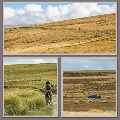
As if to rub salt into the wound, we're backing up when two trail bikes fly past us frightening the bejesus out of me as they roar off into the distance (you can't turn on these tracks, the tussock covers bumps and dips and more bogs). Back at the gate I see a blue spot off in the far distance down a side track. I zoom in and see a ute and tent; probably a hunter camped out and looking for deer. It is the beginning of the roar. We weren't alone after all.


We head home...unfinished business still unfinished.


The dark rain laden cloud has moved over the top of us now but it carries on past, up and over the top of the plateau behind without spilling a drop.


Below in the valley we can see the green patchwork of the stone fruit orchards Roxburgh is famous for. And way off and out of sight on the range across the valley is our favourite Lake Onslow.


About half way down we stop to check out this new installation over the top of a mountain stream. I have no idea how it works but it must monitor the water flow as the water eventually enters a small water canal that then winds it's way down to a farm pond at the bottom of the road. 

Perhaps it has to do with Central Otago's controversial new water allocation permits that need to be negotiated before 2021. Up until now the water drawn off has been under old mining permits which were issued as water rights by Mining Wardens under the Goldfiled Act (1858), long before data on flows and allocation were available.


It's hard to reconcile that there's a shortage of water in Central Otago, with many secondary rivers and streams running shallow or dry....


...when there's a huge volume of water flowing down the Clutha through its hydro dams on its way to the sea.

Roxburgh Dam 

Friday, February 24

Piano Flat Swingbridge Walk

Catch-up, I have a few posts to do before I continue on with Lake Onslow. This last one from Piano Flat and two or three left over from the Catlins and Winton earlier in the year. Hopefully I can get to do them over the next week while we take a break and spend a little of what's left of summer on the banks of a river in Central. I've had 4 swims in two days- that's 4 more than I've had in the last two years! I don't mind the +30c temperatures when I can cool down.


Back to Piano Flat- there was one more walk we wanted to do, a loop walk up one side of the Waikaia River to the Jack Egerton Swingbridge and back down the other. If you've been following my blogs for awhile you'll know that I 'collect' swingbridges, photos of course. They also provide a target, something to aim for on the longer walks. 

This was a 4 hour, 8km return walk according to the information and part of the walk was along the gravel road. We decided to drive to the walk exit point onto the road and then walk the 4km return section on the same side of the river. Which was just as well, as it was very tough going and took us 4 hours anyway.

We hadn't driven far up the road when we came across another digger, which we had to crawl behind until he moved a lot of debris off the road in front of him and found an area to move over...


...and once we got passed him we had to wait again while the tree trimmer machine finished sawing and moving his smaller branches off the road. You'll recall from our 4WD trip to the end of the road we had a chat with another digger driver clearing the road over the top of the range. You'll also remember that I mentioned the narrow bush tunnel formed over the road, well the chopper made short work of that. Talk about a road make-over! 

We pulled into a clearing beside a stream just in front of the machines, they had about 10kms of bush to trim ahead of them (and 12kms back down the other side). We headed off down the track beside Post Office Creek and after returning later in the day machines hadn't been back past.


It was a short distance down the track to the river, which looked absolutely stunning; quietly serene, with deep pools and large rocks...


...and in an unusual chartreuse green colour, highlighted even more where the sun shone..


Unfortunately the track was tough going, much of it had washouts into the river below...


...and debris laying across it (check the DOC orange arrow)...


... and tree slides over it. Most of it was from the recent (2 weeks before our visit) flash flood that swept down the valley. I don't even think we got to the halfway mark (1km) before we were questioning whether to go on or not. 1km doesn't sound like much but when you're constantly avoiding obstacles and watching where you step it can become very tiring. David was keen to turn around but the bridge spurred me on and we decided to carry on.


You can see flood debris caught in the bush beside David and above his head in the 2nd photo. This was a massive flood, the river bed isn't that narrow here and we're about 3 metres above the river.


As we move further up the river the number of fallen trees lining the edge grows.


The bird life was prolific and we had many visits from the local bush robins/toutouwai along the way. I'm guessing they hadn't seen anyone for awhile, they were all keen to check out any disturbed leaf litter or overturned log. 


From our vantage point high above the river and amongst the bush cover we saw several good sized trout...


...including this school doing circuits.


Finally, after what seemed an eternity but was actually only just under 2 hours, we caught sight of the swingbridge ahead of us and then as we got closer, below us. We had to slip and slide down to entrance level and be very careful not to slide even further over the edge of the rocks and into the river below. 


We found a safe ledge to sit on near the bridge and had a well earnt snack. I've been unable to find out who Jack Egerton is and why the bridge is named after him, so if anyone does know please leave a note in the comments (update- thanks to Geoff, we now know why, check the comments).


Of course after coming so far to see the bridge, I've then got to cross it. It doesn't look too bad here but it was actually quite intimidating, one of the scarier ones I've been on. 


It creaked and groaned and swung wildly- I kept having visions of all the trees passing under it during the storm and wondering if DOC had checked it out afterwards.


Holding on with one hand I still managed to take a few photos, this is looking downstream. David told me if he'd brought a rope he'd have climbed down into the river bed to give it some perspective. Yeah right.


 Looking upstream through the gorge, those are car sized boulders there.


And just to give it perspective, can you see David sitting on the ledge to the right? (click on the photo to enlarge) The water level during the flood was at least 8 metres high through here, there is debris caught in the trees where he's sitting.


Done and dusted, another swingbridge added to the bridge photo album. After a brief rest we headed off a little reluctantly, back down the track. We weren't looking forward to all that hard work again, traversing the track in reverse. It actually wasn't too bad as we pushed on without too many stops (although there were a couple of stumbles); we'd seen most of it on the way in. 

I even put my camera away in my pack which is unheard of, but not before taking this slightly out of focus photo of New Zealand's smallest bird (6-8cm), a female Rifleman/Titipounamu. They are often high up in the understory and flit fast between trees calling to their family as they go with a tiny high pitched peep-peep. They run fast, spiralling up and down the tree trunks, gripping small branches and twigs as they lean out to check for insects.


And I got my camera out again when we passed the pool with the large trout in it; he was in close and the water so clear.


Of course once we had completed the walk we were pretty pleased with ourselves that we'd done it. It was worth all the effort.

And now a few more photos because I won't be doing a blog on the extra day that we stayed at Piano Flat when we crossed the river from the campground and went birdwatching back up the track we'd walked a few days earlier. We had a few awesome finds.


Excitement! Fresh deer poo in the clearing across from where we parked.


I really wanted to sit up all night to catch them in spotlight but then I would have had to fight off these little buggers. Evans= 3, Mice =1. Although we think we caught the one that got away, he fell off the tyre and into the flexi bucket half full of water and drowned. They'd found my supply of wild bird seed!


Not far from the clearing and right in the middle of the track I found this dead New Zealand Long-tailed Bat/Pekapeka-tou-roa, possibly a dropped late night snack for a ruru/morepork (native owl) as one wing had a tear in it.This is our one and only native land mammal (although there are 3 species of bats), our other native mammals are all marine animals; dolphins, seals & whales. Bats are seldom seen and this was our very first sighting, albeit of a dead one.


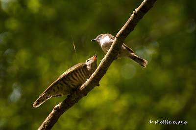
Possibly on a par with the bat was a good sighting and a long view of not one, but two Shining Cuckoo/Pipiwharauroa fledglings, squawking and chasing their frazzled foster Grey Warblers/Riroriro parents around the bush. Shining cuckoos are usually heard but seldom seen, they are masters of camouflage. The adults fly in from the Pacific Island in early spring, find a warbler's nest to lay their eggs and then swan around until it's time to migrate back there in autumn.


Two fledglings are rare as it takes a lot of work to feed them, especially when they are twice the size of their parent (photo is a little out of focus, I so need a faster lens).