Showing posts with label surf. Show all posts

April 29, 2019

Giant Dunes- Te Paki

Catch-up

From our base at the Tapotupotu Bay DOC camp ,we drove 15kms back down the main highway to visit one of the top tourist attractions in the Far North; the giant Te Paki Sand Dunes. A small inconspicuous sign post points the way down a short gravel side road to the dunes. Ahead of us, multiple clouds of dust indicate we're not the only ones visiting the dunes today and it doesn't take long for mounds of gleaming white sand to appear through the trees in front of us.


The dune carpark is busy and we're lucky to find a space, I've heard that on some days cars are parked haphazardly back along the road edge for a couple kilometres. 


The dunes are huge and from the carpark we can see a several groups of people, looking like tiny ants slowly making their way up the sides of the nearby dunes.


The Te Paki Sand Dunes are a coastal strip of ever changing sand 10km long, 1km wide and 150 metres high. The Te Paki Stream flows past in front of the carpark and heads for the coast through the middle of the dunes.


This entrepreneurial young guy from the local iwi (tribe) has the best job in the world he tells me, he says he travels the world from the back of his truck, meeting many different nationalities as he hires out sand boards to tourists that arrive to surf the dunes. He also has the gift of the gab and is well suited to his job.


I decide that it looks too much of an effort to climb to the top of the dunes and I also don't want to end up with sand in every nook & cranny so today I'll just sit and watch everyone else enjoy themselves. It's also very hot and the white sand is blinding, you definitely need sunglasses to cut out the glare.


Once people have crossed the stream (some leaving their shoes behind, they'll struggle walking over the hot sand), the climb begins easy enough but as they start climbing the steeper ridges it becomes a tough slog through the deep loose sand and I watch as feet and sometimes legs up to the knees are swallowed up by the sand with each laboured step. 

Some people decide it's just as much fun sliding down the slopes on the other side of the stream.


We have lunch at one of the picnic tables and watch as the keen ones make it to the top of the tallest dune. 


Once again I'm pleased I have my zoom lens (click on the photos to enlarge)-


Many wipe out soon after leaving the top, then it's a slow haul back up to the top.


It's recommended to take a scarf to wrap around you head; covering your ears, nose & mouth to stop the fine sand from getting in if you have a major wipe out. 


The Te Paki Stream cuts around the base of the nearby dunes as it heads to the sea. This wide braided stream bed is actually the 3km access track to the famous Ninety Mile Beach. If you've driven or taken a tour up the beach from Ahipara or any of the earlier access points, Te Paki Stream is also the last exit from the beach before Cape Reinga.


I'm disappointed when I see signs saying the track is temporarily closed due to a washout, I really want to drive through to the beach but David's not keen to take the ute anywhere there is salt water. While we're having a little discussion a Subaru shoots past us and off down the track.


I walk over and have a chat with my friendly entrepreneurial guy and he looks around furtively and then just to be sure he's not heard, he whispers from behind his hand that the track is fine for 4WDs. They (that's the royal they) have left the signs up to deter inexperienced overseas drivers in rental vehicles from driving through. He also mentions that he's been charging people a couple of hundred dollars to tow their vehicles out of the sand when they've ignored the signs & his warnings. 

I manage to convince David to at least see what's around the corner...


We follow other vehicles tracks, the sand is mostly firm and smooth although we can see where vehicles have taken a different track and become a little bogged. We meet a small tour van coming towards us, one of the occupants is standing atop a sand bank taking photos as they come through the water. The people from the Subaru that we'd seen heading down the track earlier, were now attacking the tallest dune from a different angle, clambering up the spine to the very top.

Rather than a washout, there's been a large sand slide over one section of the track at some stage. It's been packed down by passing vehicles but we still slip and slide through it before lurching out onto a very wide section of the stream bed. It's easy to follow the wrong tracks but we try to keep to the firmer wet sand until finally...


...we pop out onto Ninety Mile Beach.


Ninety Mile Beach is actually only 55 miles (88 kms) long. It is thought that European settlers named it because they knew their horses could travel up to 30 miles a day. Unfortunately they didn't account for the slower pace of travelling on sand.

Looking north to Scott Point and the top of 90 Mile Beach...


... and south along miles and miles of deserted coastline. Travel on the beach is recommended 3 hours after high tide. Most rental companies do not allow or insure their vehicles on the beach. There have been many instances of vehicles coming to grief along the beach in soft sand or being caught out by the tide which comes in a quite a pace.


David stops the ute where the fresh stream water dissipates into the sand, he's won't be going any closer to the salt water, so we walk down to the water's edge and check out a flock of seabirds resting along the wave line. You never know when you might spot an odd man out in amongst a regular flock of seabirds but today it's just a group of gulls and terns.


Another vehicle has come out from the stream bed and is quick to head south along the beach. I zoom in on it and in the background I can see clearly the tunnel in Matapia Island, a tiny island just offshore and the only one along the beach's length.


It's time for us to head back up the stream bed and once again it's difficult to follow the tracks and also remember which braiding we came through on the way down. One set of tracks cut through some soft sand and we're certain we didn't come this way earlier but we push on through and safely get to the other side. The Subaru has now gone from the base of the dunes and all they've left behind are dozens of footprints weaving their way up the dune. 


We stop alongside our mate at the truck to let him know he'll not be getting $200 from us today, wave cherrio and head on back to camp.


October 15, 2016

Beach Hop South- Lighthouse Walk, Castlepoint

Catch-up

I did ask you how many photos one can take of a lighthouse, didn't I? Well here's good selection of them for you. The weather forecast wasn't great so I was keen to do the lighthouse walk before it closed in. David was more keen to wash the dust, salt spray and road film off the vehicles so I headed off on my own, leaving him to his chores.

I love a beach like Castlepoint; when it's low tide (this is about half tide), there's a lovely wide sandy beach to walk along...


...and when it's high tide, the waves are crashing against the retaining boulders...


...in both directions


...and they come halfway up the access stairways.


At the end of the beach there's a wide sand bar that joins the mainland to the limestone reef that the lighthouse stands on. And although the sand is wet, the tide never comes right up to the boats.


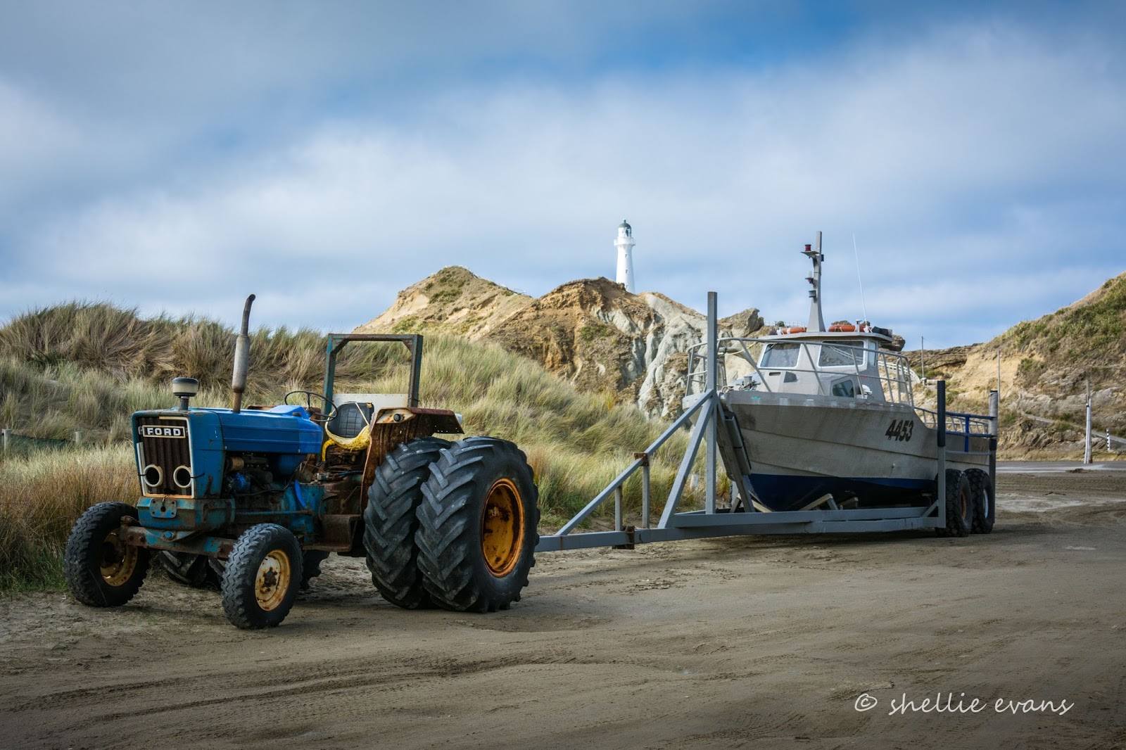
Looking like something out of a Mad Max movie, the commercial crayfishing boats are stored on the sand awaiting the next outing to retrieve their cray pots.


These are monster boats and classic Kiwi 'number 8 wire' ingenuity has been applied to the tow contraptions that haul them in and out of the water. 


We spoke to the owner of the boat below on another day (this unit looks like an old combine-harvester), and he told us about his business. It was hard work but lucrative when they could get out to check the pots. But more often than not, they weren't able to fish because of rough seas.


I kept missing the boats as they arrived back at base and were hauled out of the water; he told me he radioed ahead to his brother-in-law who then raced down to the tractor unit and backed it in and out. Which was obviously before I'd even thought about leaving the van and striding along the beach. I did manage to zoom in from the comfort of the van a couple of times though.


The baby of the group had a standard tractor.


I had Castlepoint to myself as I made my way across the sand (those are my footprints and this was taken on my way back!)...  


...towards the pathway up to the lighthouse. And although the tide might not cross the sandbar and join with the lagoon, there are signs warning to watch the tide, it does reach quite high and also if the sea is rough the waves can cut off the access at the bottom of the path.


It's very easy going up the path but there are a number of seats to rest at for the less agile. 


The view behind me is spectacular; that's Castle Rock at the back. Captain Cook named it for obviously reasons....well, obvious to him. Apparently it has similarities to the battlements of a castle. From the sea.


A panoramic shot of Castlepoint, this is 4 shots stitched together. 


This is a lovely lighthouse (I'm collecting lighthouses too)- its first light shone in January 1913. It was built to allow ships to make landfall on their voyage from Panama to Wellington and was one of the last attended stations to be built in New Zealand.


There's a worrying lack of barriers on the cliff edges around the lighthouse. I think I'd be firmly holding the hands of any children if they were with me. I spy half a dozen seals lounging around on the rocks far below.


Once past the lighthouse, a narrow stairway climbs to a point above.


I stop at every landing on the way up, not only to catch my breath- there's a brisk cold wind blowing- but to soak in that view behind. 


I still have the place to myself, and in fact I don't see another person on my travels. New Zealand like it used to be.


Castlepoint village; there's quite a number of homes on the hill behind the beach. Private & with stunning views, these can't be seen from the beachfront road below.


The stairway ends on a large platform that stretches along the top of the point and thankfully it's surrounded by a study fence. It also has magnificent 360 degree views.


I zoom in on the camping ground, and what do you know? I can just pick out David cleaning the van! So he's not telling fibs just to get out of a walk!


The cast iron lighthouse stands 23 metres high and is 52 metres above sea level. The light flashes 3 times every 30 seconds and can be seen for 26 nautical miles (48kms).


Another stairway leads you off the far end of the platform and down steep stairs to a huge rock platform on the ocean side of the point.  


Woah! This is scary stuff, it's a hundred foot drop over the edge into churning ocean below. There's a few metal screw eyes in the rocks; perhaps there used to be a wire barrier here or maybe someone uses them to anchor their rope when they go over the edge.

I'm thinking if I slipped and disappeared over the side, nobody would know. I'd be gone forever, no more photos, no more blogs. After David, I'm sure the next person to notice I was missing would be one of you! I just can't bring myself to look right the way over.


I carry on along the rocky platform and back towards the lighthouse, happy to have some dirt and vegetation separating me from that drop.

The lighthouse was fully automated in 1988 and the lighthouse keeper withdrawn. It is monitored by computer and Maritime NZ staff in Wellington.


I made my way back down to the sand bar...


...and around towards the sheltered lagoon...


...with the adventure movie name of Deliverance Cove; one of Captain Cook's better name choices. The tide lines indicate how far the lagoon reaches up the firm sand.


There's a large opening into the lagoon right below Castle Rock and also as the tide rises, waves break over two low rock barriers, filling the lagoon. 


I decide I'll wait for David to join me before exploring Deliverance Cove and Castle Rock. I make my way to the top of the large sand dunes behind me and find myself in the carpark- this is the carpark where you're allowed to freedom camp, and I can certainly see why you're likely to get sandblasted parking here. And look, there's a church for me to photograph.


A day or two later, David joined me for a repeat circuit (I did warn you there are plenty of photos, didn't I?) It's the weekend and there are a lot more people about. 


Boaties launch their boats into the safety of the lagoon before heading out to the open ocean through the entrance below Castle Rock. Other fishermen have scrambled up onto the rocky ridge that separates the lagoon from the sea. It's another terrifying drop down into the ocean swell on the other side, there are warning signs on the approach which are obviously ignored.- the fishing must be good.


A surfer makes his way along Deliverance Cove, past more vehicles and trailers awaiting the return of their boats...or high tide, whichever comes first. 'The Gap' a popular surfing break inside the sheltered waters of the lagoon, is flanked by Castle Rock and the imposing limestone reef that forms the east side of the lagoon.


As we make our way across the sandbar to the base of the lighthouse track, a scooter posse roars past us, heading down towards Castle Rock. It's not only a surprise to see them on the sand, but its also a long way to ride out from Masterton. They came prepared though, one has a spare tank of petrol strapped to his carrier.


I think I prefer the place to myself; I can't help feeling anxious when I see the places people venture.  


The view is still spectacular, and today the tide is further in.


I want to show David the drop into the sea at the bottom of the stairs but when he gets close, I can't stand it and beg him to move away. And stop fooling about, which he's now doing when he sees how agitated I am.


I think my fear is borne from once getting stuck on a cliff edge high above a boiling swirling white water cauldron of rough water at Mahia when I was a teenager. I'd followed my brother up a goat track without realising actually how steep the walls of the cove were. I was paralyzed with fear and can't remember how we got down in the end but the worse case scenario kept playing through my head for weeks afterwards.

It didn't help my case when the yound couple I'd seen earlier, suddenly appeared  below me as I was photographing the fishermen on the other point.


At least there was a ledge below the top edge along this part of the platform, I felt fine walking along along there.


 But I get vertigo just looking at this photo!


And for those that commented on not seeing my little stick man over winter; he makes a special appearance here, just for you. He was missing over winter because we were parked up with family much of the time and not out on cold walks in inclement weather.


As we were making our way back down the path, I spotted the young couple again. This time they were clambering up the rocks at the other end of point. I'm sure he was out to impress his girlfriend. He'd told me (when I took a photo for them earlier), that he was revisiting his childhood holiday destination and showing his friend the sights.


Back on the sand, I was lining up a reflection shot of the lighthouse in the tide when this girl came prancing through, photobombing my shot and disturbing the still water. No matter it wasn't a good reflection anyway and she wouldn't have realised. She only had eyes for the... 


...huge sand dune below the rock wall and her siblings playing on it. And there's another crazy couple stretching the boundaries. I need to move along before I really do have kittens.


The weather is closing in fast and this will be the last calm (and clear) view for a few days.


To be continued...yes, there's more! Can you tell we loved Castlepoint.