Showing posts with label tramp. Show all posts

February 05, 2014

Catlins River Walk

The Catlins River Walk follows the river from Tawanui (were we were camped) to The Wisp and is a one way five hour tramp. Unless you have a vehicle meet you at the other end (approximately 35kms by road) you do need to retrace your steps making this a 10 hour return hike through, at time, quite challenging terrain. The track crosses the river four times via swing bridges, the first being at "Franks Stream" a two & half hour walk away & the target for our walk.

Crown ferns crowd out the forest floor
The well defined track passes through some stunning forest scenery with beautiful Silver Beech trees as the canopy and smaller native bush, ferns & mosses filling the understory. Much of the track has exposed tree roots similar to the photo above. This makes for a very uneven surface to walk on & you have to constantly watch where you step for fear of breaking an ankle or slipping over. The track has quite a number of steep sections, a lot with steps although not all placed to match your step.


Any colour as long as it's green
It took us over three hours to reach the swing bridge due to the amount of times I had to stop to take photos. At every turn we were greeted by the beautiful colours of the bush & ferns. And then there were the many different species of colourful fungi, these are just a small selection of the different types. So many & such stunning colours. My favourite is the Purple Pouch Fungi & the black frilly one on the top row, although they are all amazing.
  
Towards the end of the section we were walking we nearly gave up wondering how much further we could manage as the track got rougher & rougher and we knew we'd have to return the same way. It was only a few days after our last tramp & I'd said then "no more for awhile!"


Sphagnum moss hung from the branches
We passed an American couple coming the other way that spurned us on. They had been dropped at the other end and were completing the full track from that direction. They would have been in their late seventies, the lady was, how can I say it, rather large & she obviously had a walking disability. They were quietly making their way up & over the many obstacles that were at this section, her with the help of two walking sticks, him with his hand at her elbow when he could fit beside her. I wondered if their accommodation hosts (a luxurious lodge) had warned them of the arduous walk it was going to be.

To make matters worse when I asked how they were getting back to their lodge once they reached the other end, they said "they were going to walk, it wasn't far". Far! It was another 4-5kms down a gravel road! That was pretty impressive, what had we to moan about! I also asked how far the swing bridge was & when they said about 30 minutes I halved that and took another 5 minutes off for good luck!
And sure enough within 10 minutes we spotted our reward. Usually it's a waterfall that's our treat but I'll take a swing bridge any day, especially "wire single person" only bridges like this one. 


We made our way down under the bridge where we had a welcome rest & a bite to eat before David went fishing for a short time. Within a couple of casts he'd hooked a brown trout that managed to spit the dummy & take off super fast. After about 20 minutes fishing time & knowing that we had a long walk back ahead of us we packed up and headed back down the track.


It was a long walk home although we covered it in just over two hours this time, our legs were turning to jelly & my feet were starting to really throb. Every muscle in my legs & thighs were starting to complain & my arm ached from holding my camera (which is quite heavy with it's big lens on) although I still managed to grab these quick shots of a rifleman that we found right back at the beginning of the track! The photo on the left gives an indication of how tiny these fast moving little birds are, they run up the trunks of trees grabbing insects on the way. These are still not good shots but I'm getting there!


Needless to say the following day was a day of rest! We both could hardly move about the van but at least we're getting fitter. I have a phone app that records the amount of steps I take each day, 10,000 is a good day of exercise. The last big walk we did was 16,500 steps, this one recorded 23,000 steps. David also has an app that tracks us & keeps track of the distance; it was a total of 10.5kms, a pretty good effort if I must say so myself!

January 27, 2014

Waipohatu Walk.....Tramp!

Monday morning & one week later we are still parked up at the Weir Beach Reserve! We keep saying we'll move on tomorrow, tomorrow comes & we decide to stay one more day & the "one more day" becomes two, then three, now four..... At this rate we'll never make it around the South Island!

We have been doing a lot of exploring and just enjoying the reserve. Over the weekend a few more families arrived to camp in their caravans and each night there has been an extra two or three sleeper vans, tents or motorhomes staying. And going by the amount of hire motorhomes & cars that we pass on the road it would seem that this place is a hidden gem not least because it's about the only place in the Catlins, so far, where we have been able to get phone reception.

A few days ago we visited the Waipohatu conservation area where there are a number of walking tracks. It The reserve is on the edge of the Waikawa Forest and is typical of the Catlins coastal forests. It was last logged in the 1960s but still has some remnants of the forest trees with the regenerating bush growing thick & fast underneath. The access roads are old saw milling roads and the carpark & picnic area, where an old Fordson Tractor log hauler still sits, was once a skid site where the logs were hauled to for transporting out.


There were two walks here, one a short 20 minute walking track through the bush, the other a 6.5km, 3 hour tramping track up to the waterfalls. We decided we'd walk the 20 minute track & then decide if we wanted to head further afield, which is what we did in the end as the longer track led off the end of the shorter walk. We were prepared for a longer hike although neither of us had our heavy duty tramping boots on just the easier to wear walking shoes. I also wasn't sure how my feet were going to cope. It's now been 6 months since my operation, the operation that was going to allow me to do all these long walks & tramps and I was keen to see how they stood up to it (no pun intended).


There were a number of bridges to cross and in places ponga logs had been laid as steps across boggy patches and up steep stretches. The bush was stunning, brilliant green with lots of tree & ground ferns & mosses. The water was stained with tannin that leaches out of the surrounding soil and leaf litter.


It was a steady climb all the way and the further we got into the bush the boggier it got. We were expecting it to dry out a little the higher we climbed but in just about every dip or low area the ground was a muddy mess. A lot of the time we managed to skirt around the edge of the mud but quite often the track was very narrow with a steep drop off at the edge or it was overgrown so there was no choice but to pick our way through the mud carefully placing each step in case we slipped.


With the promise of a waterfall at the end of the climb we kept on going although a couple of times we wondered if we should turn back. Until finally we got to the sign that told us there were an upper & lower waterfall. It's about now when you're totally buggered you wonder whether the steep descent down to the lower falls will be worth it (actually it's the steep climb out I was more concerned with).  And to make matters worse the higher falls was another separate climb up to & back. Ten minutes doesn't sound like much but when you're that bushed it's a bloody long time!


The track wound it's way down and around & over moss laden rocks to the lower falls which were stunning, although somebody could have removed that dead tree before we got there!


Long before we sighted the top falls we could hear the terrific roar of the cascading water, these were much higher, the water falling probably at least 30 metres into a small pool before being forced into two narrow gaps with a couple of huge boulders in the centre.


Unfortunately we couldn't see around the edge of the side rock to get a clear view of the waterfall; lean out too far & we would have been in the drink. The spray was also making it difficult to grab a quick look.


David tried to get across to the other side but the flat rocks were slippery & moss covered & the water deep, so he gave that away.


After the falls- which we rated 6/10 on our waterfall scale; 10 being "must see, fantastic, awesome" & 1 being "shouldn't have bothered, not worth the walk"- we had a rest & a bite to eat before heading on back to the car.

We were surprised at the lack of bird life we encountered on the walk although it was in the middle of the day so most would have been resting although we did get fleeting glimpses & we could hear quite a few, mainly grey warblers with two or three chicks in tow. But best of all we did get to see a couple of rare & very hard to spot (and photograph) rifleman, they move very fast and are so tiny, one of our smallest native birds. As you can see by the photo, I didn't manage to have my camera settings correct as I'd just finished shooting the waterfall when we spotted the birds. But with a bit of repair work at least I've got the evidence of a rifleman with a spider in it's bill.


After we left the waterfalls it was still a bit of climb upwards before the track turned and headed back down. And on this return leg the boggy patches became more frequent and the ponga stepping logs less so. Eventually the track broke out onto one of the old logging roads & it was all downhill from there, 1.2km straight down.


This was actually the toughest part as by then we were worn out and my feet were starting to really ache, also going downhill is extra hard on the knees. It was with much relief  when the road levelled out not far from the carpark. It actually took us over four hours in the end, in part because of how boggy the track was & stopping a number of times serching for birds. Our shoes were caked in mud but thankfully neither of us had slipped over or broken an ankle. And while my feet were very tender & sore, they came right after a night's rest so I'm thinking I'm good to go for our next tramp. Just not for a while.


April 06, 2013

Stony Bay & Finishing the Coastal Walk

We had one more bit of exploring before we leave the tip of the peninsula; Port Charles & Stony Bay. Both of these along with Sandy Bay are located on the eastern side of the tip and to get to them we crossed over the range just north of Colville and then turned left at the only intersection for miles, turning right would have taken us back past Waikawau Bay and on to Kennedy Bay which then loops back to Coromandel township. We were going to do this road if we had of stayed at Waikawau  before heading south but we’ve heard it’s very corrugated & extremely winding towards the end & as we're not stopping at Waikawau, it now makes sense to head back to Coromandel township the way we came up, on the western side. 


Part of a "Shoe Fence" at the beginning of the climb over to Port Charles
It was only about 14kms from the intersection to Stony Bay but it might as well have been 44kms, Port Jackson’s road had nothing on this one for winding. After 5 kms & 150 corners I lost count & at least every 3rd or 4th one of those was a sharp blind one. The road winds itself through beautiful native bush that covers most of this side of the peninsula. This is the Moehau Range, it forms the backbone of the upper Coromandel Peninsula but runs steeply down to the coastline on this side. Mt Moehau at 892metres, is the highest peak on the peninsula & is of special significance to Maori.

 
Port Charles is the first of only two settlement we come across, population 150,  it’s located on the edge of a large enclosed deep harbour & it would seem fishing is the main activity here. There is also a large mussel farm at the entrance.

The road, which is not council maintained- got narrower & no less winding from Port Charles. A along the way there were tantalising glimpses of the rugged coastline. Finally we dropped down into Stony Bay & the end of the road.


A gate opened into the DOC campground and the other end of the Coromandel Walkway which we had half completed the other day from the other end- (read about it here)

Stony Bay, as the name implies is a beach of pebbles & boulders, very beautiful & surrounded with magnificent pohutukawas festooned with huge astelia epiphytes.
 
We had brought our tramping gear but hadn’t quite decided whether we’d do the walk or not but once we got there and saw that the track disappeared up the side of the hill & into the bush, a totally different scene than the other end, we decided we’d do it now that we were here. We’d walk to the lookout which was one steep climb away from Poley Bay, where we’d ended up coming in from the other side. We could now say we had walked the 7km track apart from that small section. In fact we’ve walked nearly double the distance considering we had to retrace our steps twice.
One of the large pohutukawa that line Stony Bay
It was overcast & rather grey but there were signs that the sun was going to break through, either way; rain or hot,  it didn’t matter as we were under the bush canopy most of the way. It certainly was beautiful, the path was lined with brilliant green ferns, pongas, mamakus and dozens of nikau palm. Some areas were certainly very tropical looking especially when the track crossed one of the numerous waterfalls. The path ran around the steep slopes that fell from the range above down to the rocky coast below, it weaved in and out of the valleys between each vertical ridge and & each turn back out to the ridge edge there was a waterfall. Although with no significant rain for months the falls were more of a trickle. It would be very magical after heavy rain & a little more difficult to cross I would think.
 
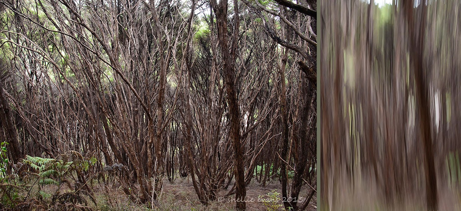
For quite a distance the track also passed through a manuka (tea tree) forest which was the highlight for me. It’s the first time I’ve seen such tall manuka, it’s usually shorter scrub but these were very tall and under the canopy were masses of relatively straight narrow trunks & branches.  On the ground grew bright green ferns which contrasted against the brown of the trunks. Looking down the steep slopes at the mass of branches gave me a touch of vertigo. I did some of my camera tricks too J
 
 
Throughout the bush and in fact all along the roadside are bright marker pointers written in various codes. These mark areas where there are pest traps or bait stations set. As most of this area is conservation land & many kiwi reside & have been released here, DOC obviously have an intensive pest eradication programme running.
That's NZ Mistletoe on the trunk
Two hours, 4.8kms and many tantalising views of the coastline & secluded bays later we finally reached the fork that led to the look out.
Centre photo- Mt Moehau
After a steep scramble up a slippery clay track we were greeted with fabulous views up & down the coast and out to Great Barrier Island. And there not very far away were the Pinnacles which were the prominent point of interest when we came in from the other end.
 
Port Charles harbour entrance is back centre

The track winds it's way back & forward over these ridges. Stony Bay is around the last point over by the green patches
We ate our lunch perched precariously on the side of the cliff. David also rescued a small stick insect that was being harassed by a wasp and then we were off again back to Stony Bay.  

It was a quicker trip back, our legs were starting to tire & by the time we reached the ute we were totally exhausted, we’d done nearly 10kms & shaved an hour of the return leg. I know this because David has an app on his phone called “My Track”, which keeps all the data. I have a few photos of him standing on various tracks looking at his cellphone. I kept thinking what’s he doing checking his phone so often. I’m thinking he’s looking for that elusive cell phone reception but he’s not, he’s checking the data. That is so typically my husband, I said he was a train-spotter ;)

We stopped in Sandy Bay just before the hill over to Port Charles for a well deserved coffee before heading home back over that winding road again. And with that we have done the northern tip of the Coromandel. We’ve got quite attached to this area & will be sad to leave.
Sandy Bay Baches


March 31, 2013

Coromandel Coastal Walkway


It was overcast today, ideal to walk part of the seven kilometre Coromandel Coastal Walkway which runs from Fletcher Bay, at the end of the road coming up the western side of the peninsula & Stony Bay, the end of the road on the eastern side. There is no road access right around the tip of the peninsula so this a great way to see this rugged & remote area. It’s a 56 kilometre drive over narrow & winding roads from one bay to the other so it is wise to either walk part of the way then return or if in a group, have a vehicle left at either end & swap keys when you meet on the track. Some even carry their tents & packs & stay overnight at either end, returning the next day.


The views are fabulous, the coastline steep & rugged with jagged rocks, offshore reefs, island & small wild rocky bays as far as you can see. This area is known as the Pinnacle Coast.


Click on the photo to see the rock fisherman in the first photo

The first section crosses the hilly farmland of the Colville Farm Park which was purchased by the Crown in the 1970s, with the intention of preserving the coastline & forested inland slopes for the benefit of all New Zealanders. It was a steady & steep climb through the first paddock where there was a large flock of sheep which had obviously decided they quite like to rest on the level track at night, most of our time was spent dodging large amounts of sheep poo.


The next open section we crossed is known as ‘The Six Foot Track’, an old bridle path constructed & used by pioneers with pick, shovel & wheelbarrow to join the two bays. Not far from here is a valley of flax that early settlers harvested for a mill that they had in Port Jackson where the fibres were dried, baled & shipped to Auckland. The tin shack set high up the slope is used by itinerant scrubcutters.


About an hour and a half after setting off the track passed through a large area of manuka scrub, then we started a steep descent down into Poley Bay which is a small compact cove with a shingle beach. This was going to be our turnaround point. Large pohutukawa, ferns & nikau palms dominated this section & it was a shame to see so many mamaku ferns (Black Tree Ferns) in various stages of dying. Apparently the endless summer as taken its toll on our native forests & especially with the ferns which need a lot of moisture & frequent rain.

 
We had a break & ate our lunch in Poley Bay and while we were sitting there a family came climbing over the rocks, they’d been exploring as the tide went out. It was a surprise to see them as it was a long way in and quite a strenuous hike to where we were. The two little boys were two & five & had walked the whole way. They were now headed back & Dad said as long as they didn’t push them they'd make it all by themselves. Although the wee one must have finally decided enough was enough as we caught a glimpse of them on the last section before home with the boy riding on his dad’s shoulders.

The climb out of Poley Bay was very steep and slow, we were both relieved to get back to the carpark at Fletchers Bay, especially as it had just started raining although that didn't seem to stop the campers from enjoying themselves.