Showing posts with label village. Show all posts

Tuesday, September 17

But Wait There's More- St Bathans

Catch-up

While at St Bathans I was determined to catch a sunrise over the lake. It was the middle of winter so I didn't have to get up too early; about 6:30am to be up at the lake just after seven. But while the late start was a bonus the bitterly cold temperatures outside weren't.  

Spot the Paradise Ducks floating near the edge
Several times through the night I'd open the door to check on the weather and each time a blast of freezing cold air would hit me. Nearly always the sky was crystal clear and inky black with a mass of twinkling stars reaching from one side of the horizon to the other. Perfect weather for a heavy frost each morning but not great for a sunrise; I needed a few clouds for the colour to bounce off. Each morning we woke to an icy frost and outside temperatures of -2c to -6c. Brrrrr.....

On the first morning when it looked like I might get a decent sunrise; by the time I reached the lake, heavy grey cloud had swallowed up what remained of the blue sky and blotted out any hope of colour.

I was waiting for something to poke it's head out of that hole, hopefully not a rat!
The cloud was quickly followed by thick fog and the temperature dropped sharply, if it could drop anymore, it was already about -2c. There was nothing for it but to head home to the warmth of the van.


A couple of days later I tried again, the conditions still weren't ideal but at least there was a little bit of wispy cloud streaking across the sky. 


The colour wasn't as brilliant as I'd hoped for, I think much of the initial intense colour was lost as the sun rose behind the Hawkdun Range before it popped over the top and filled our little corner of the valley.


On this morning I waited patiently as the sun inched its way down St Bathans Range, knowing that if the breeze stayed away there'd be some lovely reflections on the lake once it was light enough. I walked to the clay cliffs that overlook the lake and track down to the lake's edge. Once you could camp down at the lake edge but that's not allowed any more. 


A pair of Paradise Ducks (the same ones that were swimming on the lake earlier- see the 1st photo) were being chased by other ducks and landed on a pile of clay nearby. And then they spent the whole time honking and squawking at me. There'd be no chance of sneaking around the lake with a dozen or so Paradise ducks in residence, they make as much noise as though pesky Spurwing Plovers.


Afterwards I drove down to the lake and walked carefully around the edge of the lake clambering over gravel slides and more sticky clay until I could go no further.


The sun hadn't quite reached the lake but the reflections were amazing.


I've usually taken reflection photos from the tops of these cliffs on the other side of the lake so it was great to see them from a different angle.


I clicked away until my Paradise Duck pair returned to the lake and in the process disturbed the water. Soon afterwards there was a minor skirmish as three or four other ducks flew in to claim their territory.


I walked back to the carpark taking a few more photos of the cliffs below the village. You can certainly see why mining was stopped when the 'Glory Hole' got so close to the town.


Those ducks are following me around but at least they're not fighting this time!


The next day I headed back up to the lake for the golden hour; that hour of light before the sun sets,  when the light is soft and the shadows long. Though I left my run a little late, not allowing for the fact that the sun was going to disappear ahead of time behind St Bathans Range.

I quickly made my way along the cliffs, catching more beautiful reflections... 


...and making sure I captured the Post Office again in this brighter light (than the previous one I shot)


The light was perfect, the dark Blue Lake certainly living up to its name in this light.


You would think after so many visits to St Bathans, I would have realised what those black 'sticks' were on the cliffs opposite by now. I've always thought they were logs and wondered how they ended up there - ruining my perfect photos! I thought perhaps they were wildling pines that had been felled on the cliffs above and the trunks had then rolled (or were pushed) over the edge. 


Duh! After getting up close to them this time I now realise that they are rusted metal pipes, left over from the gold mining era.


Here are a couple more reflection photos...


This cream rock formation always reminds me of a resting dog or cat. 


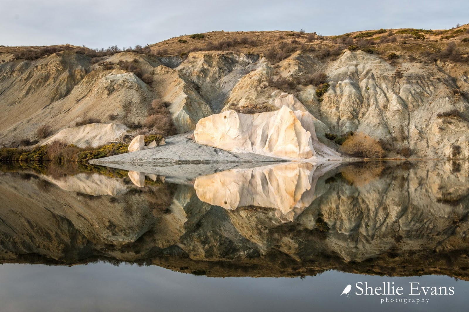
And to give you some perspective, that is a full size willow tree to the right of it (this photo was taken on my walk back after the sun had dropped)


I got about halfway down the lake before the sun finally disappeared behind the hills and it was time to turn around and head back to the ute.


But not before catching the last of the golden light at the top end of the lake.


And here's one last photo to make you smile. This is what happens when you set your self-timer too long.

'Are you going to click or what?'


Wednesday, July 20

Glacier Country- Franz Josef Glacier

Catch-up

Of course I couldn't do one without the other; so after completing the Fox Glacier walk, next on the agenda (after a few days rain) was Franz Josef Glacier,  which was just a short trip from the NZMCA Park, through the Franz Josef village...


...across the Waiho River bailey bridge, turn hard left...


...and up the access road for about 4kms, to another large carpark. Which is rather busy, probably due to the previous few days incessant rain and because Fox Glacier has been closed for a few days (due to flooding & a large rock fall). There's a tantalizing glimpse of the glacier from the car park this time, although that disappears as soon as I step onto the path.


The cardboard ranger is on duty once again and today he's telling me that I can get to within 750mtrs of the glacier and it'll be a 5.4km, 1 hour 30min, return walk. 


The first kilometre of  the well formed track passes through beautiful regenerating rainforest.


The soothing sound of a babbling stream accompanies me through the bush and in the distance I can hear the rumble of a large waterfall. The glacier comes back into view...


...and so does the source of the rumble. The track narrows and this looks to be a fairly new route as we skirt around the edge of  small mound. Trees close to the path have been trimmed, chopped or pushed over the edge out of the way.


Around the next bend is a major wash out and the old path disappears over the edge of a very large rock slide into the river below. This happened back in March when 158mm of rain fell over 24hrs. Further downstream the river burst through the stopbank and flooded one of the hotels just north of the village.


Once past the new section, the track opens up and there's a clear view up the valley to the glacier. This is where those that are less nimble can walk to for a view, after which the track drops down into the river bed, crosses a side stream and weaves up the valley.


The source of the side stream are the very impressive Trident Falls which are tucked around the rock wall on the right in the above photo.


I don't have my tripod with me but manage to take a few reasonable slow shutter-speed shots to smooth the water.


The track now officially becomes a 'route', where marker posts mark the way and can change depending on what's happening to the surrounding environment. Although it still looks like a track to me. 


Far across the river I can see two swingbridges, I've zoomed in on them here but they are hardly visible from where I'm standing. They're on the Roberts Point Track, a 12.5km return tramping track for experienced and well equipped trampers, that ends high above the glacier. Just like Fox, there are plenty of warning signs about the track, a handful of tourists have lost their lives on it; either slipping down sheer rock walls or trying to take a short cut across the river.


The Waiho River is flowing fast after the recent rain; there's a person on the track ahead of me to give you some perspective.


Looking downstream, with a peep of the Trident Falls on the point.


You may have noticed that there are no photos of David ahead of, or behind me today. That's because I'm doing the walk by myself, he decided to have the day off. So I had to find myself a new subject to include in the shots and luckily this guy obliged. He didn't know it of course but I'm sure he wouldn't have minded.


And I'm always happy to include others when they helpfully appeared in frame just as I click...


The track wound it's way up...


...and down piles of rock and sediment left behind by the glacier as it's retreated.


I thought the most amazing sight, other than the glacier itself, was the huge block of ice covered in moraine...


...on the edge of the track and left behind by the retreating glacier. Slowly, slowly disappearing into the rubble.


Finally I reach the lookout where the huge terminal face of Franz Josef Glacier towers over us. Remember, it's still 750 metres away. The river flows from the terminal face through some deep scars in the rocky valley and is also joined by numerous waterfalls cascading down the vertical rock walls.


Franz Josef Glacier, at 12kms long, is just 1km shorter than Fox Glacier and is fed by a 20 square kilometre nevé (snow accumulation area), while Fox's nevé, you'll remember, is a massive 36 square kilometres.


And there's that ranger again, he does get around.


These signs are at the beginning of both the glacier walks- they obviously had a few complaints and I can see why. The constant sound of helicopters passing high overhead distracts from the spectacular and relatively peaceful landscape even though they're not that loud, more like an annoying mosquito buzzing in your ear. But it's a means to an end and many visitors enjoy the close up experience of flying over and walking on the glacier. It's also the reason drones are banned from the glacier valleys.


I did enjoy watching the helicopters fly in though and they did look just like tiny mosquitoes. This should give you an idea of how big the glacier is. That's the helicopter flying in from the right- (remember to click on the photos to enlarge)


Little red dot- centre right (now that's a wow moment, isn't it?)


I kept thinking it was surely going to hit the glacier as it moved in...


...for a closer look (both them and me)...


And then landed on the glacier where it disappeared out of sight for perhaps two minutes...


...before rising, sweeping across the rock face, up, off and out to the left...


...to be replaced by another helicopter that either came in from the back of the glacier like this one, or followed the same route as the previous one, up the valley. A 20 minute flight, with snow landing, will set you back a cool $235 per person! There are various other longer options available, with prices to suit of course.


Cloud started to roll in over the top of the surrounding mountains and the glacier...


...and it was time to head back down the valley.


Cloud was filling the glacier valley as I passed the last lookout (or first, depending on which way you're heading). And by the time I reached the carpark, the glacier had totally disappeared. Those people that I passed, heading up the track, would have been out of luck and wondering at what they missed. Such is the fickle nature of this alpine environment.


Now which glacier would you visit if you only have time to walk to one? It's a question often asked on a travel forum I frequent. I'm afraid I can't choose one over the other, they are both stunning walks through some magnificent scenery to view two very impressive glaciers. You decide.