Before we left Christchurch I managed to do a quick tour over the Port Hills through Dyers Pass to Governors Bay and then back to Weddons via Gebbies Pass, roads we hadn't explored on any of our previous visits to the city. I was waiting for a fine day, but in the end I had to do it on another not-so-great day similar to the one I had when I explored Godley Head at the other end of the hills.
First stop was at the very busy Sign of the Kiwi cafe, an iconic Christchurch landmark; built in 1916-17 as a staging post and opening as a tearoom and rest house. The cafe was closed after the 2011 earthquake and didn't open again until January this year. Just a month later it came very close to being destroyed in the massive Port Hills fire.
I drove along the Summit Road and up to the top of Sugarloaf where another iconic Christchurch symbol is located; the radio & television communications tower.
From there the views are expansive out over the city, across the Canterbury Plains to the Southern Alps behind. In the foreground the regenerating hillside is slowly recovering after the devastating February fires raged out of control and burnt over 1650 hectares of the Port Hills. The Sign of the Kiwi is located just out of sight to the left, where the two sections of the Summit Road meet (click to enlarge).
Parts of the badly damaged Adventure Park including the chairlift can been seen across the valley.
The dead pine trees are slowly being removed.
The fires were ferocious and burned on both sides of Dyers Pass Road and also jumped the Summit road below and burnt up to where I'm standing.
Here's a photo taken during the fire from below, Sugarloaf and the communication tower can be seen at the back, on the left.
I carried on a short way past Sugarloaf until Governors Bay came into view down the inside of the Port Hills rim. I'm heading to the other side of that first finger of land and crossing over Gebbies Pass at the lowest point of the hills behind.
I then returned to Dyers Pass and drove down to Governors Bay, stopping to take a photo of the Governors Bay Jetty (see it in the photo above?) which looks a similar length to the well known Tolaga Bay wharf, north of Gisborne. It was closed and in need of repair; a noticeable section in the middle sagging into the tide.
Next stop was the historic St Cuthbert's Church which was built in 1860.
It was extensively damaged in the September 2010 earthquake and had only just reopened after a major rebuild.
With the temperature dropping and the day not getting any brighter it was just a few quick stops at places of interest as I wound my way along the very tight and winding roads that follow along the edge of Governors Bay...
...until I reached the old Blacksmith building on the corner of Gebbies Pass Road where I turned inland...
...and found two more churches to add to my collection- St Peters Anglican Church at Teddington...
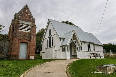
...and the Anglican Church of the Epiphany in Gebbies Valley, which must have one of the most elaborate belfries in all of New Zealand's country churches.
And then it was home to Weedons, to pack and prepare to move on out.


Thank you Shellie I so much love you pictures it looks so different with the ferocity of the fires and earthquakes since I was young.The time we visited was the time a young prince visited the same place at the Blacksmith's if I remember rightly but I did not like the drive down the road at all.
ReplyDeleteThankyou zephyr, I'm pleased you enjoyed the photos and reminiscing. I don't blame you for not liking that road, is not an easy one to travel- the locals of course whizz through there like they haven't a care in the world.
DeleteShelly did you know Margaret Mahy use own that point you referring at her oldest daughter Penny owns it now and lives there,we lived for 30 years in Governorsbay and right next to the Mahy's.Nice photos by the way
ReplyDeleteNo. I didn't know that Ton, thanks for letting me know. What a lovely spot to live although I'm not so sure I'd enjoy travelling the Pass into Christchurch that often. Glad you enjoyed the photos.
Delete