Showing posts with label summit road. Show all posts

Friday, September 8

Port Hills- Dyers Pass and Gebbies Pass

Catch-up 

Before we left Christchurch I managed to do a quick tour over the Port Hills through Dyers Pass to Governors Bay and then back to Weddons via Gebbies Pass, roads we hadn't explored on any of our previous visits to the city. I was waiting for a fine day, but in the end I had to do it on another not-so-great day similar to the one I had when I explored Godley Head at the other end of the hills.

First stop was at the very busy Sign of the Kiwi cafe, an iconic Christchurch landmark; built in 1916-17 as a staging post and opening as a tearoom and rest house. The cafe was closed after the 2011 earthquake and didn't open again until January this year. Just a month later it came very close to being destroyed in the massive Port Hills fire.


I drove along the Summit Road and up to the top of Sugarloaf where another iconic Christchurch symbol is located; the radio & television communications tower.


From there the views are expansive out over the city, across the Canterbury Plains to the Southern Alps behind. In the foreground the regenerating hillside is slowly recovering after the devastating February fires raged out of control and burnt over 1650 hectares of the Port Hills. The Sign of the Kiwi is located just out of sight to the left, where the two sections of the Summit Road meet (click to enlarge).


Parts of the badly damaged Adventure Park including the chairlift can been seen across the valley.


The dead pine trees are slowly being removed.


The fires were ferocious and burned on both sides of Dyers Pass Road and also jumped the Summit road below and burnt up to where I'm standing.


Here's a photo taken during the fire from below, Sugarloaf and the communication tower can be seen at the back, on the left.


I carried on a short way past Sugarloaf until Governors Bay came into view down the inside of the Port Hills rim. I'm heading to the other side of that first finger of land and crossing over Gebbies Pass at the lowest point of the hills behind.


I then returned to Dyers Pass and drove down to Governors Bay, stopping to take a photo of the Governors Bay Jetty (see it in the photo above?) which looks a similar length to the well known Tolaga Bay wharf, north of Gisborne. It was closed and in need of repair; a noticeable section in the middle sagging into the tide.


Next stop was the historic St Cuthbert's Church which was built in 1860. 


It was extensively damaged in the September 2010 earthquake and had only just reopened after a major rebuild.


With the temperature dropping and the day not getting any brighter it was just a few quick stops at places of interest as I wound my way along the very tight and winding roads that follow along the edge of Governors Bay...


...until I reached the old Blacksmith building on the corner of Gebbies Pass Road where I turned inland... 


...and found two more churches to add to my collection- St Peters Anglican Church at Teddington...


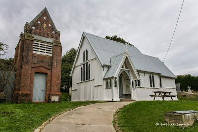
...and the Anglican Church of the Epiphany in Gebbies Valley, which must have one of the most elaborate belfries in all of New Zealand's country churches.


And then it was home to Weedons, to pack and prepare to move on out.


Tuesday, August 1

Godley Head Defence Site, Christchurch

Catch-up

From Lake Opuha we headed to one of our regular NZMCA Parks; Weedons on the southern boundary of Christchurch city where we were welcomed by a number of stunning sunrises. 


This was one of the sunrise views looking south, away from the rising sun. It was quite strange with a distinct band separating fluffy cloud from the blue sky beyond.


Of course spectacular sunrises are usually followed by an overcast or rainy day and so it was the case for most of our time in Christchurch. 


We've visited Christchurch numerous times but usually use our stay as a rest period and to catch up on chores in the city. I was hoping for a sunny day when I headed off to explore Sumner Beach, a coastal seaside suburb 30kms away on the eastern side of  the city and also to do a tiki-tour to Godley Head and travel the Summit Road on the Port Hills overlooking Christchurch.

Sumner Beach & Cave Rock
It was not to be though, instead a smoky haze hung over the city on a bitterly cold day. At the top of a short steep drive up Evans Pass Road, I stopped to take a photo overlooking Sumner below and across to South New Brighton and New Brighton. You can see the New Brighton Pier poking out into the sea in the middle distance.


The views along the Summit Road are spectacular, so close and yet so far from the bustling city below. I'm heading to Godley Head Park at the tip of the northern side of the entrance to Lyttelton Harbour. It's a 10km drive from Sumner to Godley Head and while the road is narrow, it's sealed all the way and not a particularly difficult road to drive; just don't get distracted by the views, it's a very long way down. And watch for oncoming traffic, it's mostly one way.

You can see part of the road cutting along the top of the hill in the photo below. There are a couple of sharp switchbacks in the Evans Pass Road that you'd need to watch in a bigger vehicle- we wouldn't probably be able to get our fifth-wheeler around them. 


I stopped often to take in the views. In the photo below one of the many walking and mountain bike tracks that criss-cross the Port Hills can be seen, this one is between Godley Head and Taylors Mistake. Across the secluded Taylors Mistake Bay are the earthquake sacred cliffs of Scarborough Hill and beyond that, Sumner Beach. 


The road weaves its way from one side to the other along the top of the headland, this is looking down into Lyttelton Harbour on the inside, the port and township of Lyttelton are tucked around the corner at the far right. The harbour entrance is to the left and across the water is Diamond Harbour.


Godley Head is the most complete WW11 coastal defence site in New Zealand today. It's now a public park administered by DOC (Dept. of Conservation). Click on the photos to enlarge if you'd like to read more.


The plotting room, miniature range & engine room buildings are still located on the hillside above the entrance to the harbour.


It really was a bitterly cold day with what I'm sure was a sub-zero wind chill factor, so it was a surprise to see people as mad as me visiting the park. I passed a guy carrying a load of photographic gear on my way down to the buildings. He told me he'd been doing a photoshoot, I found his model still at the buildings, she was taking a few selfies herself, and freezing in the process. 


I've included a photo of each of the buildings with their information board because I know there are a few people out there who'd like to read about the background (remember to click on the photo to enlarge).

The Battery Plotting Room-


The latrines would have had the best views in the whole base-


The Engine Room- 


This was the most fascinating building, like a big boys game of Battleships (which I guess it was)
The Miniature Range-


Back near the carpark were a collection of hatches, pipes and shafts-


Perhaps one of my readers will know more about these- 


Further towards the tip of  Godley Head and overlooking the ocean are the remaining buildings from the Military Camp. It is also now a DOC Camp and would be a great place to stay in the summer, especially with all the walking and biking tracks that weave their way up, down and over the headland. Bookings are essential; once your fees are paid you're sent the combination number for the lock on the gate. Dogs on a lead are welcome too. 


 I walked down to the handful of buildings; some are well looked after, others not so much.


The battery compound was closed off, the two photos of the small grey gun emplacements above are part of the compound that I took through the fence.


I also took this photo (black & white) looking across the Lyttelton Harbour entrance to the headlands that form the north side of Banks Peninsula.


Back in the ute, with the heater turned up to full, I headed back towards Evans Pass Road (the lower road) but carried on along Summit Road. Can you can see a small white dot? That's a car coming down the road. 


I stopped a few more times to take photos, the haze over the city hadn't improved but the wind had picked up considerably. The Avon and Heathcote Rivers flow through the city and empty into the estuary here.


With so many walkers and bikers in the Port Hills I'm sure this is a welcome relief to passersby. Supplied courtesy of a resident on Summit Road.


I was hoping to drive right along the Summit Road and drop down into Lyttelton but it was closed beyond Mt Pleasant Road so I drove back down to sea level and headed home (I believe it was closed initially because of the earthquake but now permanently, to allow a safer environment for bikers and walkers in the area).


Monday, July 7

Around the Bays- Pigeon Bay

Banks Peninsula comprises of two extinct volcanoes which were active less than half a million years ago. The two craters have since enlarged many times their original size due to erosion and water flow, then around 15,000 years ago when the sea level rose dramatically, the craters were flooded, these now form the two main harbours of Akaroa & Lyttelton. Many smaller bays & coves indent the remainder of the coastline.

The Summit Road, a very popular “Tourist Drive” runs around the Akaroa crater rim affording spectacular views of the harbour and surrounding valleys and ridges. There is also a Summit Road around the Lyttleton Harbour; we are leaving that side of the peninsula for another time.


Two days after the snow fall we thought it would be safe enough to travel the summit road and visit some of the bays on the northern side of the peninsula. We stopped at The Hilltop, a hotel & cafe at the top of the long climb (from both directions; Christchurch & Akaroa) A light covering of snow still lay on the ground and the surrounding peaks. We started along Summit Road and straight away became concerned at the possibility of black ice. In fact this wasn’t black it was just plain old ice (bottom left), sheltered from the elements it had started to melt and then refroze. We eased our way through it carefully and were then relived to see that most of the snow had melted further on.


There were many vantage points along the road to check out the spectacular views of the harbour and bays down below, including Duvauchelle Bay and our camp ground.


Our first port of call was Pigeon Bay, the road dropping sharply down to the bay from the Summit Road. The roads down to the bays may only be 6-8kms long but they take a while to navigate. Steep, narrow & with dozens of hairpin bends you have to take your time & hope that you don’t meet anybody coming up.

Pigeon Bay is a small settlement, just a few baches & farm buildings at the head of the bay. Oh and a church. We drove around to the end of the road where we could see a jetty & some boat sheds, coming across this deserted camping ground on the way. It was like stepping back into the 1970s with these closed up old retro caravans, an overgrown tennis court complete with rusty fence, an old wash tub set up with wringer in the centre, concrete table & chairs arranged to watch the sunset and a notice board informing us we could stay for $10 a night. I’m sure in the summer time this place would be pumping but today it was deserted, it was quite eerie wandering about. Like everybody had been nuked! 


At least the boat club had a decent building but still nobody about, the holiday home right on the side of the road looking straight down the bay was closed up, we were tempted to sit and have our lunch in their Cape Cod chairs but thought better of it.


Instead of heading back up the road out of Pigeon Bay, David drove around to the otherside of the bay, the camp caretaker, Glen, had told him about a road that would take us out to the head of the bay on the west side. The road we were on continued on all the way through to Port Levy, it was another narrow, steep & winding road and not recommended for motorhomes or towing.

After a few kilometres we turned off onto a gravel road, actually more of a gravel track. It climbed steeply up the side of ridge, with a sheer drop on the drivers side down into the valley below. This is at the top looking back towards Pigeon Bay settlement at the end of the bay, the jetty and boat sheds are across the water.  I spied this house out on the point, what a fabulous place to live, looking straight down the bay.


Once on the top we weaved our way back & forward across farm land crossing many cattle stops heading for the small point we could see ahead of us.


As we got nearer we realised that there was a tiny sheltered cove with farm buildings on the left of the point. This bay is called Little Pigeon Bay. We stopped at the top of the road just through the gates. Even though it was a public road we didn’t want to disturb the people we could see down at a house near the beach getting ready to go sailing.


The view over Pigeon Bay to Wakaroa Point was breathtaking. Right along the otherside we could see the tiny track of the Pigeon Bay Walkway which is a five hour return walk through farmland out to the point.


Looking back towards Pigeon Bay settlement, with mussel floats from a mussel farm in the waters below.


After a short while we headed back up the road passing the young farmer & his wife driving in. Luckily they were at the top of the steep road otherwise that would have been fun. No passing, a 100 metre drop & him with a trailer on the back. He told us the house at the beach was a bach & was rented out for holidays. We passed a large homestead along the way, all closed up and overgrown but not that old, well probably 1950ish but still in good condition. We’ve seen a few like this on our travels, obviously just too far away from civilization.


This sheep must have one of the best views in New Zealand. In the background you can see the walkway track cutting through the slope just up from the water.


After safely negotiating the steep road again, this time with me on the scary side, we stopped in the valley to watch dozens of wood pigeons (kereru) in a feeding frenzy amongst the flowering tree lucerne. Great big bumble footed clumsy birds jumping from bush to bush bending the tiny supple branches over under their weight. Pigeon Bay of course!

Bird on a Wire