Showing posts with label akaroa. Show all posts

October 14, 2021

A Visit to the Mainland

Catch-up; March 2021

Back in late March, Royalty arrived in the high country. Family Royalty that is. Mum & Dad who came to check out Night Sky Cottages for themselves. They flew into Christchurch from Napier on a direct flight and I met them at the airport after catching a bus from Twizel. We hired a car and I drove them back to the cottages, they hadn't been in the South Island for many years so it was great for them to sit back & enjoy the scenery.

For the first ten days we relaxed at the cottages and fitted in day trips (complete with a picnic lunches) around the Mackenzie Country. One of our first trips was to Aoraki/Mt Cook National Park.
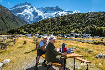
Mt Sefton & White Horse Hill Campground- Aoraki/Mt Cook
The weather was fabulous, we'd timed the visit just right, not too cold nor too hot. Just stunning blue bird days. 


It was an especially calm day when we visited Lake Ohau &  the Ohau River weir, the water crystal clear.
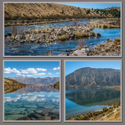
T-Ohau River, Left- Ohau River outlet, Right-Lake Ohau & Ben Ohau
Looks like Banksy's been visiting the high country too. Rude Kids- on one of the canal towers 


I took them to see some of my my favourite places- Lake Ruataniwha


Oahu C Camp Lagoon at Lake Benmore; autumn was just around the corner.


We took the long way back to Christchurch; down the Waitaki Valley to Oamaru, checking the dams out as we went and stopping at Kurow for lunch & a hot drink on the way.


Followed by a pit stop at Duntroon where the art on the toilet block brought a smile to our face. The A2O Cycle Trail (Alps to Ocean) passes down the valley too. There's now a new toilet block nearby but I think they've left this there as well.


While Mum & Dad rested up at the Oamaru Air BnB we'd booked for the night, I took myself on a walking tour of the Oamaru Public Gardens which I thoroughly enjoyed, especially the colourful blooms in the hothouse.


The next day we headed off to Christchurch, first stop just up the road at the Rainbow Sweets factory shop. Just for a look of course. We all have a sweet tooth although I think Mum & I take the family cake for scoffing our loot in no time at all. Dad tends to make his last a few weeks (if Mum doesn't find his stash). Half an hour & several large bags of sweets later we made it back to the car. 


Our next stop was Riverstone Castle, one of my favourite places to visit whenever I am passing. I knew Mum & Dad would enjoy a visit too.


We had a lovely lunch at Riverstone Kitchen before exploring the gardens & shops. Dad looked very pleased with his favourite Blue Cod & chips ('rabbit food' passed over to me). I had great delight in letting him know that this particular dish was our 'takeaways' back in the original Level 4 & 3  lockdown last year. We spent that Lockdown just down the road at the Glenavy Waitaki Holiday Park & Riverstone Kitchen supplied takeaway fish 'n chips when we moved to Level 3. 


Mum was in her element, she had a craft shop at Bay View in Hawkes Bay for many years and spent her 'retirement years' selling at craft markets. She even met and had a natter with the owner, Dot, who was unpacking stock. 


For the next few nights we stayed at an Air BnB in Rolleston (near Weedons NZMCA Park, where David was due to arrive from Twizel with the 5th-wheeler a couple of days later).

Dad wanted to do a tiki tour of Akaroa Peninsula, he hadn't been on the road around the top of the rim before. We stopped at Little River for a morning coffee and then I turned off at the summit and travelled clockwise around the top. Which was just as well when Mum saw how far down it was on some of the road edges on the inside or when I pulled over to show them the view.
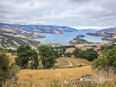
Akaroa Harbour, Banks Peninsula

Once down from the top we had lunch & an icecream in Akaroa township before heading home.


When planning the trip I had asked Dad if he wanted to visit some of his old haunts; he's a born & bred South Islander. At the time he'd said no he wasn't fussed but once we were in Christchurch we decided we couldn't get this close & not check his old hometown out. He was born in Woodend just north of Christchurch, went to school in Woodend and also spent some time in Sefton just a little further north before his family shifted north to Havelock North in Hawkes Bay.
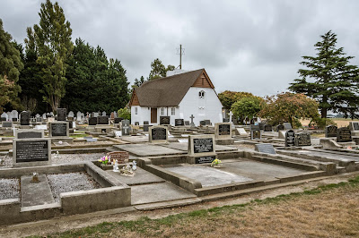
St Barnabas Anglican Church, Woodend

So we did the obligatory tour, stopping at the family church (which is on the main highway) and finding many of his Eder relations on the cemetery burial list. Next stop was Dad's primary school, then locating his old house (with add-ons) down a back road & checking out the cenotaph roll of honour for relatives & finding his Uncle Jim Eder listed there. 

Then it was off to Sefton where some of his cousins still live. We drove a few more back roads, Dad giving us a running commentary of who lived where & what went on there before finding our way back onto the main road near Saltwater Creek where he used to go white-baiting with his cousin. Funnily enough the rest area beside the creek is where we often stop for lunch or a cup-of-tea break when we're travelling. 


And then before we knew it it was time for them to fly home. We all had a lovely time and for me it was great to spend some quality time with Mum & Dad and show them around our new home province. 


July 13, 2014

Lands End, Banks Peninsula

I bet you didn’t know New Zealand had a Lands End, well not quite, but it does have a Lands End Road. It’s an isolated gravel road (another one) that runs along a ridge out to the point on the south side of the entrance to Akaroa Harbour. To reach it, one must first wind one’s way around the bays on the south side of the harbour, passing through settlements with the familiar names of French Farm Bay & Wainui.

It is usually just past Wainui that most people would turn around and retrace their steps back to tarseal & civilization. A U turn is normally performed just below the sign that reads ‘Road suitable for 4WD only, no campervans or towing’. Not us, we drive on, climbing sharply up & up we go, until we finally break out of the bush and discover this magnificent view down the harbour and out the heads.


Before we disappear over the top we pull up and take in the 360 degree views up the harbour, Akaroa is in the first bay on the right, Wainui on the left & Duvauchelle is up at the head of the harbour.


And now that we are higher up we can see down to the coastline below and can see five salmon pens that belong to the Akaroa Salmon Farm. Through the binoculars we can see a boat nearby and men working at the nets.


At the top we turn into Lands End Road but decide after just a couple of hundred metres to turn around. It’s blowing a howling southerly gale and quite miserable outside, the tussock is shimmering in waves as the wind sweeps across the ridge & I just about get blown off my feet when I get out to take a photo. And even though it doesn’t look like it here the road runs a fair distance along the top. Looking at the map we can see it doesn’t quite reach the point so we’ll not achieve much by driving to the end.


We head south west along the top of the hills, easing our way around Bossu Peak until we now have a view down both sides; the harbour & Akaroa township on the inside…..


…and Peraki Bay and the Pacific Ocean on the sea side.

 
In this photo taken from Akaroa township you can see the ridge we are travelling along and Bossu Peak. You can see the line of the road just below the top of the ridge.
 
 
There are many coves & inlets along the southern side of the peninsula, the valleys are narrow & steep as you would expect from an extinct volcano. There are a handful of houses in some of the bigger valleys and from the sign posts we see that there are at least two farm stations on this wild & windswept side.

We see a car parked up, the only one we come across while up the top.
I think this must be the highest  “No Beach Access” sign I have ever seen. I can’t imagine that anybody up here would be looking for a beach. I’m assuming it would be great diving & fishing down there in the coves & I suspect that this is the reason the sign is there. As you can see the sun was low, I thought I’d leave my shadow in there to add interest!   The green bush area is a DOC reserve and this was where we saw the one & only car on the whole road. It was parked near where I am standing but there was nobody in sight. We assume they must have been down in the reserve although there was no walking tracks, just a predator fence. Maybe he was checking that out.


The road along the ridge….


….and as we start to drop down the other side


Looking back towards Bossu Peak (712m) on the left & Carews Peak (794m) in the middle & some of the road we have just travelled.


It’s about here that we hit snow again, I check ahead at the first section, the white stuff is soft (as it should be) but the tracks are ice & I nearly slip arse over kite when I step out onto it. I walk ahead urging David to bear right as there’s a steep drop off on the left. At the next section David goes to check & nearly ends up on his butt in the snow. I don’t think he believed me before. It’s treacherous, one wrong step and you’re over in an instant. It fascinates me that I can see a cycle track through the snow. You got to be keen to cycle all the way up here.


There are two roads that can take us back down to the valley floor & the settlement of Little River on this side, the recommended one is on the other side of the last section of snow, you can see it running along the face of the hill below. You can also see the outline of the Southern Alps top right, Lake Ellesmere in the centre, the Pacific Ocean and Kaitorete Spit on the top left and the dirty brown sliver in the sunshine middle right is Lake Forsyth near Little River.


We decide that the last section of snow ahead of us is too icy to drive on so we turn around and head back along the road a few hundred metres to the start of the other track. Talk about steep and narrow and with dozens of short switchbacks, it’s just about a vertical drop. No wonder this is not the recommended track. If we’d met anybody coming up we both would have been in trouble, the track was barely wide enough for the ute & with no areas to pass, one of us would have had to back up & I’m positive it wouldn’t have been us. Finally down on the lower slopes the road levelled out and we found ourselves in Okuti Valley where there was quite a number of secluded houses tucked into the hillside in amongst the bush.

At the end of the valley road is Little River, where we stop for a coffee. It was a Saturday and the cafe was full of city folk; cyclists, bikers & lunchalot ladies- lycra, leathers & pearls! Little River is obviously the destination for weekend warriors! It felt rather strange knowing that just a short while ago we were up above Little River, high in the sky exploring a wild & isolated area with not a soul in sight and here just a few hundred metres below us was the noise & chatter of civilization. I wonder if they know what they are missing.

Top- Silo Stay, ecofriendly Little River accommodation. My first thought was ‘I hope they are insulated’ (they are, with natural wool). A rather strange concept to my mind and I’m not sure they’re in the right area. Perhaps they are hoping to attract cyclists of the cycle trail.
Bottom left- Historic Little River Railway Station
Bottom right- St John the Evangelist Catholic Church, Little River. Another casualty of the Christchurch Earthquakes.


After our coffee we drive out to Birdlings Flat & the Kaitorete Spit to have a look, you’ll remember the spit separates the huge Lake Ellesmere from the ocean. The road along the spit is 18kms long and after seeing that it flat and  barren & there’s not much of interest that we can see, we turned around after about 5kms.


Boy racers obviously know about this strip of tarseal going by the amount of wheelie marks on the road. Heading back down the straight, Te Oka Peak (685m) on Banks Peninsula ahead of us. We didn’t quite reach the top of that peak, turning down the steep track just before it.

 
Right beside the spit and on the edge of Lake Ellesmere is the Kaituna Lagoon and when we drove past it on our way to Banks Peninsula the other day we spotted three white herons(Kotuku) feeding near the road. We drove back to the lagoon to see if we could spot them again. We pulled into the carpark after seeing one white heron feeding beside the cycle track that ran through the middle of the lagoon. As we walked up the track fourteen Royal Spoonbills flew in and started feeding and then we spotted what looked like a small white heron with the larger one. I couldn’t contain my excitement when I realised that it was a Little Egret, another very rare visitor to New Zealand.

“The little egret is a small, hyperactive ‘white heron’ with a slender black bill. First recorded in New Zealand in 1944, there are 2-3 little egrets present here most years, with single birds often staying at the same site for many consecutive years.
Little egrets are scarce annual migrants to New Zealand, arriving in autumn and departing in early spring, with some individuals remaining over summer. They are usually seen as single birds, with the largest New Zealand flock being five birds.” - NZBirdsOnLine

In this shot below there are five species; 3 herons- the White Heron, the White Faced Heron (can you spot it?) & the Little Egret, Royal Spoonbills & Black Swan.


Top left- Here you can see the size comparison between the White Heron & the Little Egret
Top right- The Little Egret takes flight
Bottom left- Little Egret, unfortunately he was very flighty and I couldn’t get too close. It was still very windy & I think this helped me get some shots at least. I’m sure he would have flown sooner if there had been no wind.
Bottom right & centre- White Heron (Kotuku)


The Royal Spoonbills decided they didn’t want their photo taken either.

July 07, 2014

Around the Bays- Pigeon Bay

Banks Peninsula comprises of two extinct volcanoes which were active less than half a million years ago. The two craters have since enlarged many times their original size due to erosion and water flow, then around 15,000 years ago when the sea level rose dramatically, the craters were flooded, these now form the two main harbours of Akaroa & Lyttelton. Many smaller bays & coves indent the remainder of the coastline.

The Summit Road, a very popular “Tourist Drive” runs around the Akaroa crater rim affording spectacular views of the harbour and surrounding valleys and ridges. There is also a Summit Road around the Lyttleton Harbour; we are leaving that side of the peninsula for another time.


Two days after the snow fall we thought it would be safe enough to travel the summit road and visit some of the bays on the northern side of the peninsula. We stopped at The Hilltop, a hotel & cafe at the top of the long climb (from both directions; Christchurch & Akaroa) A light covering of snow still lay on the ground and the surrounding peaks. We started along Summit Road and straight away became concerned at the possibility of black ice. In fact this wasn’t black it was just plain old ice (bottom left), sheltered from the elements it had started to melt and then refroze. We eased our way through it carefully and were then relived to see that most of the snow had melted further on.


There were many vantage points along the road to check out the spectacular views of the harbour and bays down below, including Duvauchelle Bay and our camp ground.


Our first port of call was Pigeon Bay, the road dropping sharply down to the bay from the Summit Road. The roads down to the bays may only be 6-8kms long but they take a while to navigate. Steep, narrow & with dozens of hairpin bends you have to take your time & hope that you don’t meet anybody coming up.

Pigeon Bay is a small settlement, just a few baches & farm buildings at the head of the bay. Oh and a church. We drove around to the end of the road where we could see a jetty & some boat sheds, coming across this deserted camping ground on the way. It was like stepping back into the 1970s with these closed up old retro caravans, an overgrown tennis court complete with rusty fence, an old wash tub set up with wringer in the centre, concrete table & chairs arranged to watch the sunset and a notice board informing us we could stay for $10 a night. I’m sure in the summer time this place would be pumping but today it was deserted, it was quite eerie wandering about. Like everybody had been nuked! 


At least the boat club had a decent building but still nobody about, the holiday home right on the side of the road looking straight down the bay was closed up, we were tempted to sit and have our lunch in their Cape Cod chairs but thought better of it.


Instead of heading back up the road out of Pigeon Bay, David drove around to the otherside of the bay, the camp caretaker, Glen, had told him about a road that would take us out to the head of the bay on the west side. The road we were on continued on all the way through to Port Levy, it was another narrow, steep & winding road and not recommended for motorhomes or towing.

After a few kilometres we turned off onto a gravel road, actually more of a gravel track. It climbed steeply up the side of ridge, with a sheer drop on the drivers side down into the valley below. This is at the top looking back towards Pigeon Bay settlement at the end of the bay, the jetty and boat sheds are across the water.  I spied this house out on the point, what a fabulous place to live, looking straight down the bay.


Once on the top we weaved our way back & forward across farm land crossing many cattle stops heading for the small point we could see ahead of us.


As we got nearer we realised that there was a tiny sheltered cove with farm buildings on the left of the point. This bay is called Little Pigeon Bay. We stopped at the top of the road just through the gates. Even though it was a public road we didn’t want to disturb the people we could see down at a house near the beach getting ready to go sailing.


The view over Pigeon Bay to Wakaroa Point was breathtaking. Right along the otherside we could see the tiny track of the Pigeon Bay Walkway which is a five hour return walk through farmland out to the point.


Looking back towards Pigeon Bay settlement, with mussel floats from a mussel farm in the waters below.


After a short while we headed back up the road passing the young farmer & his wife driving in. Luckily they were at the top of the steep road otherwise that would have been fun. No passing, a 100 metre drop & him with a trailer on the back. He told us the house at the beach was a bach & was rented out for holidays. We passed a large homestead along the way, all closed up and overgrown but not that old, well probably 1950ish but still in good condition. We’ve seen a few like this on our travels, obviously just too far away from civilization.


This sheep must have one of the best views in New Zealand. In the background you can see the walkway track cutting through the slope just up from the water.


After safely negotiating the steep road again, this time with me on the scary side, we stopped in the valley to watch dozens of wood pigeons (kereru) in a feeding frenzy amongst the flowering tree lucerne. Great big bumble footed clumsy birds jumping from bush to bush bending the tiny supple branches over under their weight. Pigeon Bay of course!

Bird on a Wire