Showing posts with label Cavalli Islands. Show all posts

Sunday, March 17

Mahinepua Peninsula Walkway- Northland

Catch-up

The Mahinepua Peninsula Walkway track leaves the beach at the north end of Mahinepua Bay. I'd highly recommend this walk if you are in the area visiting or camping. It is one of the most stunning short walks I've done, with fabulous views over a spectacular and dramatic coastline.


The 3km (one way) DOC walking track weaves it's way along the narrow spine of the peninsula to a trig point at the far end. There is access to a number of small coves during the first half of the walk, ideal places to stop for a quick swim or a picnic lunch.


The walk starts innocuously enough, through a small pine plantation and alongside private property. I thought it was very kind of DOC to send in the lawnmower and weed-eater workers a day ahead of my walk, the track was in pristine condition.


The track proper starts on the seaward side and then climbs a little way winding around a small bluff back to the bay side of the peninsula and through a stand of large overhanging Pohutukawa trees...


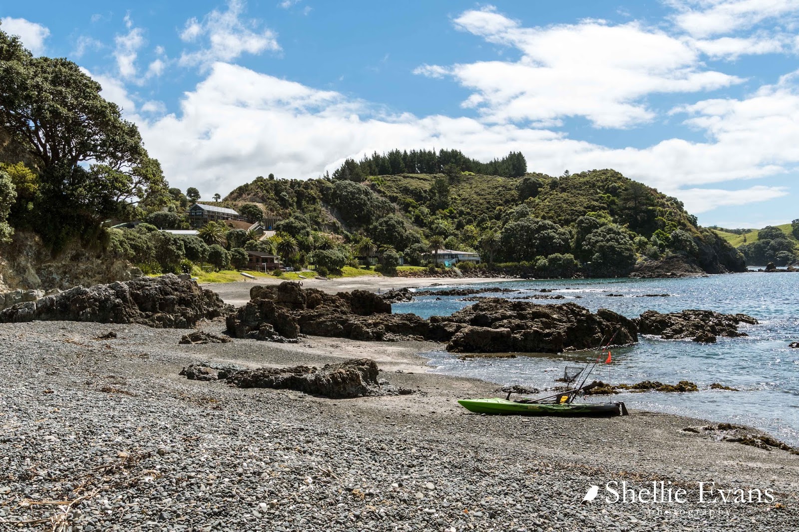
...before breaking out into the open where there are magnificent views back to the campsite and beach at Mahinepua.


Outer Mahinepua Bay and the Cavalli Islands are ahead as the track...


...drops down to one of  the sheltered coves. From here I can also see the track winding it's way around the next hill....


...and up a steep stairway in the distance which is where I spot a person ahead of me disappearing over the top (click photo to enlarge)


Down in the cove the flax bushes are in flower and a few tui are flying about fighting each other for the nectar. I love early summer when the tall plump flower spikes are shooting skywards from the middle of the bushes. Blue waters, golden sand and flowering flax must be one of New Zealand's most iconic sights.


There was a tui on this bush but he departed before I could capture him so you've got the flower spike instead!


The view back towards camp gets even better from the top of the next climb; that's the cove below now from the other side.


Once the track reaches the stairway, which is on the ocean side of the peninsula...


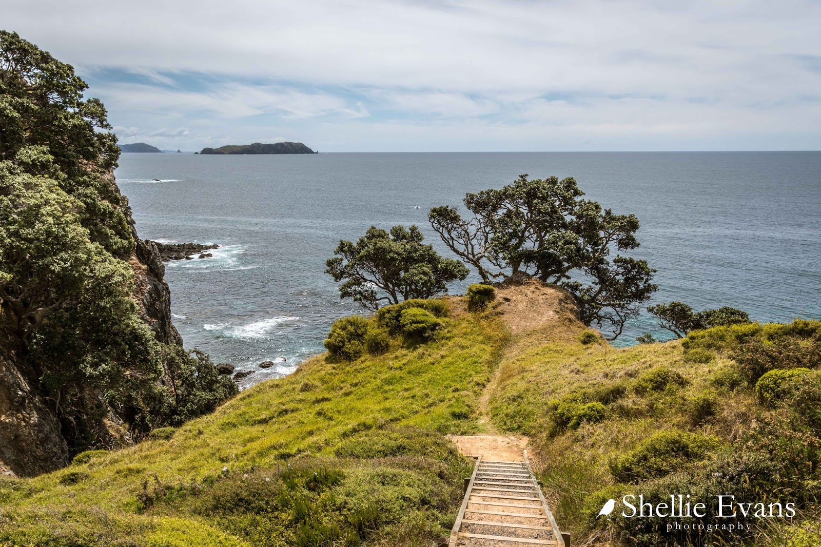
...the views are spectacular looking north along a rugged coast, the cliffs drop into the deep emerald green sea with swirling white water rising and falling around the many small reefs and rock stacks dotted along the shoreline.


The higher you climb the better the view back to camp gets...


And towards the top of the stairs you can also see up the coast towards Whangaroa Bay & Harbour; the large island is Stephenson Island/Mahinepua Island which is just off Tauranga Bay.


There's a beautiful stand of Mamaku (Black Tree Fern) with their feathery lime green fronds spread wide through the regenerating bush on the inside of the peninsula...


...just before another short sharp climb to the top where the scrub has been tortured into shape by the prevailing winds racing up the cliffs from the sea below.


And from the top, the highest point on the walk, there are now magnificent views along the coastline looking north.


Towards the end of the track there's a short loop option which I take.


It adds more interest to the 'there & back' track and only another 5 minutes to the complete walk. I'm still pretty chuffed that DOC have been in to do the track as it would have been tough walking in the long grass with all the seed heads and black pollen floating about.


There are more reefs and rock stacks below and also sudden drop-offs from edge of the track, care would need to be taken if you had children with you.


It's not long before the end of the track and the final destination comes into view; Pakuru Point & Omiru Trig which is up on the top right beside the red dirt (wait, have I walked to Aussie?) 


I took the left hand track at the fork which proved to be the better option as it was mostly downhill until it joined up with the main track again where there's a very conveniently placed seat. From here you can also see the two islands that sit just off the tip of the peninsula; Motuekaiti & Motueka (Flat Island)


Then it was just a short uphill section to the trig station...


... and from there I could see back along the peninsula, the side track I'd taken in clear view.


Just ahead of the trig, a sign warned of dangers ahead. Of course me being me (inquisitive &/or nosy), I wanted to know what the danger was and what was on the otherside of those bushes....like dozens of other people by the look of all the footprints in the red dust.


I squeeze through the bush, scratching my arm on a broken branch in the process (punishment) and come to an abrupt halt. Ahead of me are the two islands and the last thin spine of the peninsula which looks to be slippery red rock layered in dust and with steep sides. This area would be treacherous in the wet. Though today, if I was younger and my balance better (and I had someone with me),  I'd probably attempt to walk along there but then again that is why I have a very good zoom lens...


I don't have to do the hard (or scary) yards, I just zoom in on the point. And then spot that Motuekaiti Island had some large Phoenix Palms and Norfolk Pines (both non-natives) growing near a sheltered bay.


I would say that there was once a colonial homestead/holiday home in this quite sheltered bay and the palms were planted in the gardens.


I had lunch back at the seat and then headed for home, passing the only two people I saw on the track (other than the guy disappearing over the top earlier).


The following photos may look similar to some of the earlier ones but I'm now shooting with my wide angle lens so the views are even more spectacular as they take in a much wider vista, they are also a slightly different colour due to the lens I'm using and the tone is shoots. 


And finally back overlooking the camp and sheltered waters of Mahinepua Bay. It was a fabulous walk and well worth doing if you are able to, if not than you've walked it vicariously with me! 


Monday, March 4

Matauri Bay- Northland

Catch-up

Once again I have struggled to keep up with my blogs, we've just had the most amazing summer up north and have only just returned to familiar territory (Mt Maunganui) where I don't feel the need to get 'Out There' every spare moment and shoot anything that moves (or not as the case may be). I shall now try and post regularly and catch-up a little before the next adventure begins.

And a side note; I couldn't not mention that this blog post is number 800. Yes, you read right, 800 blogs! My first one 'How it all began'  was dated August 2012, six and half years ago. And what adventures we've been on since then. Of course I probably could have doubled that number because my blogs aren't like other blogs; meant to be short & concise. Most of them are short stories! I've also recently passed 900,000 clicks (views), roll on one million!


We said a fond farewell to Kerikeri and headed north (little knowing we would be returning for an unplanned and lengthy stay in the not too distant future).


It was just 30kms to our next stop at the Matuari Bay Holiday Park where we parked beachfront, right on the edge of  the beautiful sheltered sandy beach of Matuari Bay...


...but not before having to do a 20 point turn with the rig on the back after Mr TomTom led us astray. 
He very rarely gets it wrong, or if he does I usually pick it up well in advance, but not this day. Mr TomTom decided to take us via the local whanau camp at the southern end of the bay. It didn't help that we had to continue on to find a wider area in the track to turn around after spotting the sign . I'm sure I saw several smirks on the faces of a group of locals sitting in the nearby shade. 


It was still early summer and other than a handful of full-timers in their last weeks of  wintering over at the camp, the holiday park was virtually deserted. Just us...


....a couple of hundred ever present, eagle eyed gulls...

'What do you think Charlie, you think they'll have food?'
...and several dozen rabbits who made themselves at home underneath and around our van; this one taking time out beside our power pole and letting me walk around outside without bounding off at the slightest movement.


I suspect that in fact we were intruding into their home territory, several baby rabbits lived under the caravan-come-cabin we were parked beside. It was fun to watch them out the tinted lounge window chasing each other, jumping and high kicking before racing back under the caravan as fast as they could when they spotted any movement.

A Rustic Kiwi Cabin
A few tourists arrived each evening to stay the night. These ones seemed to be so enamoured with their surroundings, they sat outside their van long after nightfall, wrapped up against chilly night air, reading their e-readers while soaking up the inky blackness and the stunning night sky. They were still there at 11pm when I stepped outside to check the rig over before going to bed.


At the north end of the camp and on the otherside of a small headland is tiny rocky Putataua Bay, an ideal place to snorkel, fish or launch a small boat or kayak from.


A walking track to the top of the headland leaves the camp beside Putataua Bay, it's a short sharp walk to the top but rest stops can be taken at the gaps in the pohutukawa trees that line the track. The views over the camp, the beach and out over Matauri Bay are magnificent.


The views from the top are also just as spectacular overlooking the Cavalli Passage & Cavalli Islands. In another life we spent a night anchored in Horseshoe Bay- the bigger bay to the right- while we were en-route to Whangaroa Harbour. The island doesn't look so big from up here.


The most important feature and the reason most people walk the track though, is to see the clifftop memorial to the Greenpeace ship, the Rainbow Warrior. The Rainbow Warrior, after being bombed by the French while it was moored at Marsden Wharf in Auckland (1985)- and with the loss of one life- was sunk beside the Cavalli Islands and now provides an artificial reef for divers.


A nearby boulder sculpture has engravings of the islands and a brass inlay indicating the resting place of the Rainbow Warrior (which is at the north end of the islands)


Just in front of the memorial, the cliffs drop away to the ocean below, there's only a small shin high wooden railing so do be careful if you have children with you.


Here's a pano of Matauri Bay, the campground and Putataua Bay.


I walked up the track several times during our stay, it also seemed to be a track that many of the locals walked for exercise; I captured this group of friends walking back along the beach one evening.


With the Cavalli Islands just 3kms offshore, Matauri Bay provides an excellent launching point for fishing and diving boats to be launched including local diving companies who take divers out to the Rainbow Warrior wreck.


I walked along the beach several times during our stay, capturing more 'friends'; a group of Black-backed gulls...


....the silky smooth sand and some amazing cloud formations.


At the south end of the bay, nestled below Matauri Hill on a rise overlooking the beach, is the historic Samuel Marsden Memorial Church (1896) named in honour of the missionary's arrival in the bay.


After Marsden's arrival on December 20th, 1814, he travelled down to Rangihoua and preached his first sermon on Christmas Day, 1814. You'll recall we visited Rangihoua Heritage Park & the Marsden Cross Walkway in the last blog.


Of course being on the east coast the sunrises were spectacular and always different, and being early summer, not too early at around 6am.


The sunsets weren't half bad either; the top 3 shown below are sunrises, the bottom 3 are the coral coloured hues of sunset.


Before long it was time to head off again, back on the road slowly making our way to the top of the North Island. Not far past the turnoff to Matauri Bay there's a lookout that gives a great view of the bay and islands.


Next up- Mahinepua and Tauranga Bay