Showing posts with label flax. Show all posts

March 17, 2019

Mahinepua Peninsula Walkway- Northland

Catch-up

The Mahinepua Peninsula Walkway track leaves the beach at the north end of Mahinepua Bay. I'd highly recommend this walk if you are in the area visiting or camping. It is one of the most stunning short walks I've done, with fabulous views over a spectacular and dramatic coastline.


The 3km (one way) DOC walking track weaves it's way along the narrow spine of the peninsula to a trig point at the far end. There is access to a number of small coves during the first half of the walk, ideal places to stop for a quick swim or a picnic lunch.


The walk starts innocuously enough, through a small pine plantation and alongside private property. I thought it was very kind of DOC to send in the lawnmower and weed-eater workers a day ahead of my walk, the track was in pristine condition.


The track proper starts on the seaward side and then climbs a little way winding around a small bluff back to the bay side of the peninsula and through a stand of large overhanging Pohutukawa trees...


...before breaking out into the open where there are magnificent views back to the campsite and beach at Mahinepua.


Outer Mahinepua Bay and the Cavalli Islands are ahead as the track...


...drops down to one of  the sheltered coves. From here I can also see the track winding it's way around the next hill....


...and up a steep stairway in the distance which is where I spot a person ahead of me disappearing over the top (click photo to enlarge)


Down in the cove the flax bushes are in flower and a few tui are flying about fighting each other for the nectar. I love early summer when the tall plump flower spikes are shooting skywards from the middle of the bushes. Blue waters, golden sand and flowering flax must be one of New Zealand's most iconic sights.


There was a tui on this bush but he departed before I could capture him so you've got the flower spike instead!


The view back towards camp gets even better from the top of the next climb; that's the cove below now from the other side.


Once the track reaches the stairway, which is on the ocean side of the peninsula...
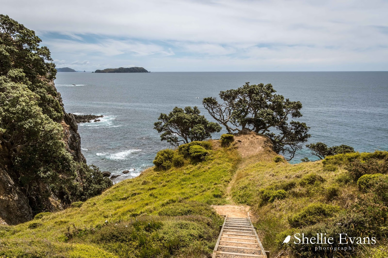

...the views are spectacular looking north along a rugged coast, the cliffs drop into the deep emerald green sea with swirling white water rising and falling around the many small reefs and rock stacks dotted along the shoreline.


The higher you climb the better the view back to camp gets...


And towards the top of the stairs you can also see up the coast towards Whangaroa Bay & Harbour; the large island is Stephenson Island/Mahinepua Island which is just off Tauranga Bay.


There's a beautiful stand of Mamaku (Black Tree Fern) with their feathery lime green fronds spread wide through the regenerating bush on the inside of the peninsula...


...just before another short sharp climb to the top where the scrub has been tortured into shape by the prevailing winds racing up the cliffs from the sea below.


And from the top, the highest point on the walk, there are now magnificent views along the coastline looking north.


Towards the end of the track there's a short loop option which I take.


It adds more interest to the 'there & back' track and only another 5 minutes to the complete walk. I'm still pretty chuffed that DOC have been in to do the track as it would have been tough walking in the long grass with all the seed heads and black pollen floating about.


There are more reefs and rock stacks below and also sudden drop-offs from edge of the track, care would need to be taken if you had children with you.


It's not long before the end of the track and the final destination comes into view; Pakuru Point & Omiru Trig which is up on the top right beside the red dirt (wait, have I walked to Aussie?) 


I took the left hand track at the fork which proved to be the better option as it was mostly downhill until it joined up with the main track again where there's a very conveniently placed seat. From here you can also see the two islands that sit just off the tip of the peninsula; Motuekaiti & Motueka (Flat Island)


Then it was just a short uphill section to the trig station...


... and from there I could see back along the peninsula, the side track I'd taken in clear view.


Just ahead of the trig, a sign warned of dangers ahead. Of course me being me (inquisitive &/or nosy), I wanted to know what the danger was and what was on the otherside of those bushes....like dozens of other people by the look of all the footprints in the red dust.


I squeeze through the bush, scratching my arm on a broken branch in the process (punishment) and come to an abrupt halt. Ahead of me are the two islands and the last thin spine of the peninsula which looks to be slippery red rock layered in dust and with steep sides. This area would be treacherous in the wet. Though today, if I was younger and my balance better (and I had someone with me),  I'd probably attempt to walk along there but then again that is why I have a very good zoom lens...


I don't have to do the hard (or scary) yards, I just zoom in on the point. And then spot that Motuekaiti Island had some large Phoenix Palms and Norfolk Pines (both non-natives) growing near a sheltered bay.


I would say that there was once a colonial homestead/holiday home in this quite sheltered bay and the palms were planted in the gardens.


I had lunch back at the seat and then headed for home, passing the only two people I saw on the track (other than the guy disappearing over the top earlier).


The following photos may look similar to some of the earlier ones but I'm now shooting with my wide angle lens so the views are even more spectacular as they take in a much wider vista, they are also a slightly different colour due to the lens I'm using and the tone is shoots. 


And finally back overlooking the camp and sheltered waters of Mahinepua Bay. It was a fabulous walk and well worth doing if you are able to, if not than you've walked it vicariously with me! 


April 16, 2015

Punakaiki- Pancakes & Blowholes

Continuing on with our journey down the Coast-

We left Westport just as the rain started to fall and it really hasn’t stopped much since. As the locals say- ‘you can’t have a rainforest without the rain’. But then I’ve also heard them complaining too!

I spotted this poem on a cafe wall which just about sums it up-
Rain
It rained and rained and rained
The average fall was well maintained
And when the tracks were simple bogs
It started raining cats and dogs
After a drought of half an hour
We had a most refreshing shower
And the most curious thing of all
A gentle rain began to fall
Next day but one was fairly dry
Save for one deluge from the sky
Which wetted the party to the skin
And then at last the rain set in
                                                       Anonymous
We’ve cursed it the odd day, but mostly we’ve just got on with it. Because we have no time frame it’s just a matter of sitting out the rainy days (great for catching up on blogs) and venturing out in between showers. One bonus is that we’ve had plenty of rain water to top up our drinking water containers and our house water tanks have been full to overflowing many times.

We made our way down the coast passing through some amazing coastal scenery- the bits we could see between downpours.


I kept reminding myself that we’ll be back this way someday before we bring this journey to an end. But there will be one beach that I’ll return to very soon- a very special beach that not too many people know about. I’m hoping I’ll visit it when we return to Greymouth after we’re finished with Hokitika (which, for those that are directionally challenged is south of Greymouth so we’ll be doubling back to Greymouth for a few days and then crossing over the Divide via Arthurs Pass).

Hokitika will be as far south as we’ll travel the West Coast this time- we'll come up from the bottom of the island to complete it later in the year. We need to get to Christchurch to have some servicing done before the onset of winter…..although I think we missed the memo that says it’s already started! There’s snow on them thar hills.

I’ve passed through Punakaiki twice in my lifetime stopping for a short visit both times, one I can’t remember and the second time was when David and I caught the TransAlpine train across to Greymouth from Christchurch about 17 years ago and then we headed north and over Lewis Pass to Hanmer Springs for a short break. I can hardly remember that visit to Punakaiki either- just a few snippets here and there but one of them was the amount of Nikau Palms that lined the road- Punakaiki didn’t disappoint this time either.


There wasn't too much traffic on the road and when we did pass a vehicle it was mainly hire campervans, so it was a surprise to suddenly round a corner and find a lot of activity in the carparks and on the roadside as we passed the entrance to Punakaiki Rocks.  We’re definitely in tourist country now. We also had our first foreign tourist driver episode (which for my overseas readers has been a major issue in NZ over the summer) where a driver had stopped in the his tracks on a narrow winding section of the road and was backing up. Not pulling over to the left and waiting to do a U turn, just backing up, up a winding hill. Luckily we saw his reverse lights and were able to pull up well in advance. I gave him a polite smile as we passed.....yeah right!

We planned to stop at a CAP (costs apply parking), a NZMCA park over property in Punakaiki for a few nights and we found it just south of the Rocks and right beside the Punakaiki Resort. We were familiar with the resort, we stayed there not long after it opened and when it was known as the Punakaiki Eco Resort, now we were sharing the same beach. The CAP was a great place to stay, a large raised gravel area that had obviously been prepared for subdivision, very close to the blowhole & local walks, and with a wild west coast beach just through the flax bushes. It was just a pity it rained solid for 2 out of the 3 days we stayed, and rained on and off on the 3rd day. But we did get to witness a very impressive thunder storm and light show out over the ocean one night.


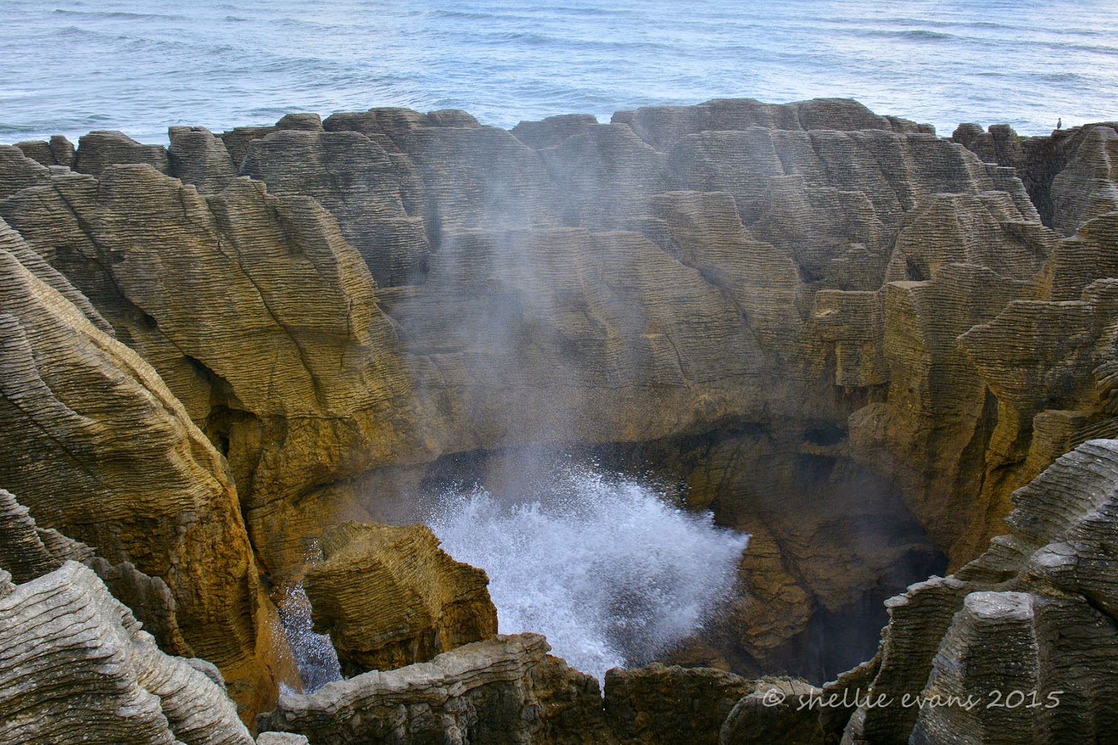
Of course our first visit had to be to the famous Pancake Rocks and Blowhole at Dolomite Point, which are located just off the main highway at Punakaiki. The 20 minute loop walk starts out in native rainforest with many Nikau Palms before passing through dense flax and coastal vegetation as it nears the rugged coastline.


There are numerous formations and smaller blowholes in amongst the rocks before you get to the main iconic blowhole, Putai. This surge pool is called the Devil’s Cauldron and at high tide it lives up to its name as the waves gush in from the sea channel and break against the rock sides getting bigger and higher as the tide rises.


 From the information panel-
Looking like giant pancakes the unusual limestone formations were formed 30 million years ago from minute fragments of dead marine creatures and plants that landed on the seabed about 2 km below the surface. Immense water pressure caused the fragments to solidify in hard and soft layers. Gradually seismic action lifted the limestone above the seabed. Mildly acidic rain, wind and seawater sculpted the bizarre shapes.

The main attraction, is of course, Putai – the largest blowhole – where on stormy days the seawater swells upwards from the rocks in a giant wall of spray. Coinciding high tide with a westerly wind is the best time to visit the blowholes as then the water is forced through underneath the rocks and up into the blowholes producing huge plumes of sea water.

Today, it wasn’t quite high tide and there was no wind but the sea was still a little rough (from the storm overnight), so we managed to see a few reasonable blows.


The Chimney Pot Blowhole-


The walkways, railings, platforms and information panels have been very well done and I’m sure the many hundreds of visitors that walk the track every day, leave feeling they’ve seen an impressive and unique landscape and also learnt a little about how it was formed. Of course a good show by Putai would be the icing on the cake but I don’t think it’s totally necessary to be impressed by this spectacular coastline.

If you look closely, you can see our van parked up near the beach in the background of the photo on the top right. That’s how close we were to the Pancake Rocks.


After the blowholes the track carries on around the edge of the rocks and at one point disappears down through a narrow rocky gap before climbing up the other side….


…to a lookout point, looking north up the coast. It’s late afternoon and the sun makes a brief appearance….along with a rainbow over the top of the rainforest.


There is another well known walking track just up the road from the Pancake Rocks that is also well worth a visit. The Truman Track begins again in a beautiful sub-tropical rainforest of ferns, nikau palms & rimu trees with this coastal tarn (is there such a thing?) right beside the carpark.


As the track nears the coast it passes through dense coastal flax again before emerging onto a headland with stunning views up and down the coast. At this point my memory is jogged; I knew David & I had visited an area before, where we’d climbed down onto a beach underneath a cliff overhang- I thought it was back at the Rocks but that was clearly impossible when I saw how rugged that area was. This was the spot!


A stairway leads down the north side of the headland to a gravel beach with cliffs, caves, a waterfall, more amazing rock formations and what looks like an extinct blowhole. The beach is accessible only at low tide and even then it’s quite scary with the rough seas and crashing waves. I leave David in the cold wind, scanning the ocean for seabirds while I climb down over the boulders and under the tiny waterfalls that are dripping off the rocks above.


I want to take a photo of the waterfall that looks like it’s flowing out of the rock wall at the far end of the beach.


I take a few slow shutter shots to get a silky ribbon of water, but the wind is blowing hard and most of the shots have the water flow at a weird angle.