Showing posts with label Chinese. Show all posts

Friday, September 9

Moa Creek Cemetery- Ida Valley

Catch-up, late March 2016

A few days after our Upper Manorburn road trip we did another long day travelling a circuit that took in the Ida and Manuherikia Valleys in Central Otago. We'd travelled both valleys on previous visits but there were a few places we hadn't stopped at before, and one place that had been closed which we'd put on our 'must visit on a return trip' list (I have a few of those!). It was a lovely warm late summer's day which also made it much more pleasant exploring. 

Here's the first of a few 'shorter' blogs on the trip (yeah right), we stopped at a number of places and they all deserve their own spot in the limelight.

Moa Creek Hotel (former)
Our first stop was at Moa Creek, we've stopped here and passed by on a number of occasions on our way to Poolburn Dam. The old Moa Creek Hotel stands on the corner of  Poolburn Road. I'd looked for the Moa Creek Cemetery previously but couldn't locate it. This time I wasn't leaving until I found it. 

There are no sign-posts but by scanning the nearby paddocks with my binos, I located a tiny hill with, what looked like headstones on top, with an information shelter roof at the base. Problem though, it was across a large paddock of knee-high (and higher in some places) lucerne with no visible track. 


There was nothing for it but to 'bushwhack' a route through on a more or less direct line, which was fine until I came to a large boggy patch and then a pond, both surrounded by lucerne double the height. I heard a few scurrying noises as I moved through the crop, a duck flew out once, but I tried not to think about what the others might be. Heavy dew made it hard going and soon my legs and boots were soaked. Eventually the soil soured, the crop thinned and was patchy near the cemetery, making it much easier to walk.
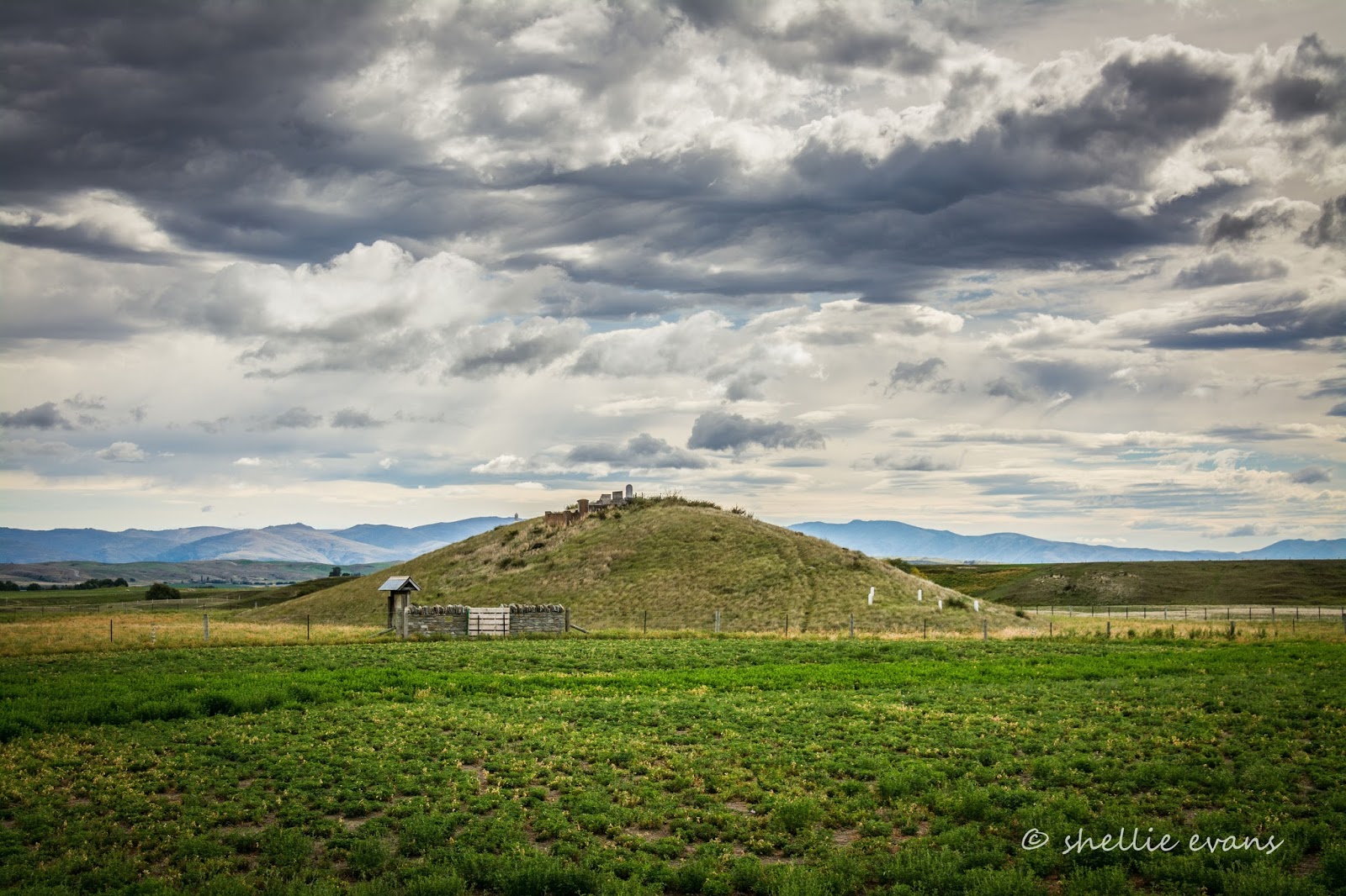

After 30 years of neglect and with the threat of the historic cemetery being reclaimed by the land, a restoration project was instigated in 2010 by the descendants of those buried in the cemetery.


Although it would seem that the lovely wrought-iron gate is not stock proof- a pallet protecting the entry into the cemetery!


I hope you can read the information panels- they're not the best quality but I know there's a few people out there who like to know all the background history- hi Dad!  (Click on the photo to enlarge).


As is also the case with many of the early cemeteries, the Chinese had their own section, here it's at the foot of the hill.


Some of the Chinese headstones were located at the Alexandra Museum and were returned to their original positions.


At the top of the hill the graves don't look towards Moa Creek...


... they face north, taking in the magnificent view right up the Ida Valley to the Hawkdun Range.


A wrought-iron fence surrounds the MacIntosh family plot which takes a commanding position on top and at the front of the hill.


Stabilization of MacIntosh Memorial Column was done as part of the restoration work.
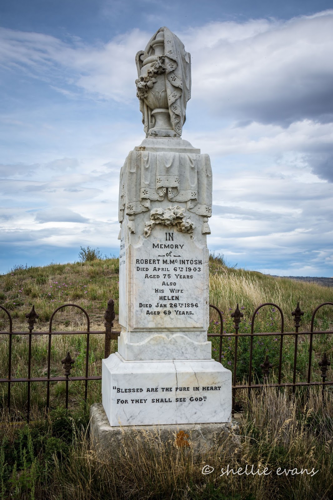

Some of the grave sites still need a bit of work and it's a shame the weeds and rabbits have made themselves at home around and under the plots. It'll not be long before the cemetery succumbs to the ravages of time once again.


New Zealand's pioneer families certainly had a lot of heartache.


It's just as well some of the headstones have holes drilled in the stone to form the letters, it looks like a dark filling was then inserted in the letters (which has now fallen out of most of them). It's a pity this wasn't done on a lot of the headstones I've seen at old cemeteries where the words (and history) have long faded away.


I took a few last photos and fought my way back through the lucerne to the road where David was patiently waiting for me.


We headed off, north up the east side of Ida Valley coming across a flock of sheep being moved, along the way.


The dogs were whistled in to push the sheep over to the left and the shepherd called out that we'd be right to head along the verge to get past them. 


Trouble is, once the dogs set about barking, the sheep took off at a gallop and stretched so far out that we had to take evasive action to miss a deep overgrown drain that suddenly sprung up in front of us towards the end. A sharp yank of the steering wheel to the left by 'Possum Bourne' and we just cleared the culvert, very nearly bowling a couple of sheep in the process. 


Leaving the flock behind we carried on up the road passing the historic Ida Valley Station woolshed on the way.


Our next stop was at the famous Idaburn Dam which looked totally different to our last visit when it was full of water and nearly frozen solid.


It was a shock to actually see how shallow the pond was and to even see half a dozen sheep grazing on the surface towards the back.


The ice had started to melt around the edges on our last visit and we were concerned about people walking on it or attempting to skate (we could see recent blade marks). But having now seen the depth, it wouldn't have been so bad after-all if they had fallen through the ice while skating (just cold legs & a bruised ego).

A Frozen Idaburn Dam- August 2015
The Idaburn Dam appears in a number of TV ads and is often shown when there’s a hoar frost in the Maniototo. It’s also the home of the Roaring Game, that ancient Scottish sport of curling and is famous for the Bonspiel, the grand tournament which occurs when (and only when) the ice reaches 14cm thickness. That’s when the Ice Masters put out the call to curlers nationwide to come and play within 48hrs- an event I'd love to capture. Perhaps next winter we'll be somewhere close and I'll hear the call too.


Saturday, May 10

“The Nevis”- There & Back: Part 1

You will remember that we drove the Upper Nevis when we did the 4WD safari over Nokomai Station back in February. After we left Arrowtown we planned to stay in Cromwell (beside the lake again) for a few days so we could explore the Lower Nevis & the Nevis Gorge before we left the area. We were hoping for a fine day but with rain forecast we decided to drive it the afternoon we arrived at Lowburn, it was dry but with high cloud and haze.

The north end of the Nevis Road starts out the back of Bannockburn where it climbs sharply up Long Gully on the Carrick Range. Along the way we pass Dead Horse Pinch; many horses didn’t make it up this steep incline when pulling wagonloads of mining dredge pieces up into the valley. The high altitude Nevis Valley, was first settled by pastoral farmers in the late 1850s & then my gold miners in the 1860s.


Looking back from the top of the range we can see all the way up the Upper Clutha Valley, including Cromwell and Lake Dunstan. The Pisa Range is to the left, the Dunstan Mountains to the right & according to the signpost & a farmer who stopped to tell us, Mt Cook and the Southern Alps can be seen at the top left of the lake. On a clear day. Which it wasn’t.


At the summit- Duffers Saddle1300m; it was considerably colder at the top with a few snow patches in the lee of the rock stacks left over from the heavy fall that the region had a week or so ago. Behind the schist rocks which are known as “The Two Sisters” are the Remarkables.


The dry tussock landscape is covered in clumps of speargrass & dotted with huge & wonderfully shaped schist tors.


The road is dry and dusty as it snakes its way across the top of the saddle and then drops dramatically down into the valley below.


The Nevis River and the Lower Nevis Valley stretch out in front of us. The valley consists of two sections, each is about 6kms long separated by a 4km gorge. We can see the beginning of the gorge at the far end. The second section is where we made it to when we came in from the other end.


In the photo below, the road can be seen running along the lower ridge at the right. Much of the high country seen across the valley belongs to Ben Nevis Station and up behind the station is Ben Nevis itself, which is 2234m high. We’ve actually spent a bit of time at another Ben Nevis, Ben Nevis (1344m) is near Fort William in Scotland and is the highest peak in the British Isles. We were there for the Downhill Mountain Bike Championships a few years ago when we had a team racing our 2Stage Bikes. NZ’s Ben Nevis is a baby amongst our mountain peaks, our highest mountain is Mt Cook (3754m) which would be a giant at nearly three times the height of Scotland’s Ben Nevis.


Down in the valley there are very few signs of settlement over 150 years ago when up to 600 people lived along the river in two settlements. An abandoned house & a prospector & his caravan on the river not too far from the bridge; we saw the claim sign nailed to a pole at the roadside, are reminders of present day habitation while a stone wall is all that’s left of the “Nevis Crossing Hotel”, it now forms part of the Ben Nevis Station’s cattle yards and across the river a few broken stone walls are the only signs of buildings from the Nevis Crossing settlement all that time ago.

The Nevis River bridge dates from 1904 and replaced the original bridge which was swept away by great sheets of ice after the Nevis thawed when the river froze in 1903. This was & is still is a harsh and unforgiving environment especially in winter. A cluster of stone & wood buildings behind a woolshed belong to Ben Nevis Station. Cattle gathered on the road ahead of us as we approached the woolshed & when I get out to take a photo of the buildings two farm dogs come bounding down the driveway to see who had stopped. They give the cattle a quick burst around the paddock & then retreated back up the drive, satisfied they were still the boss.


Further along the road we take a short detour to the lonely Nevis Cemetery set up a slight rise with the huge expanse of the valley stretched out in front of the graves, Pioneer land owners and miners laid to rest overlooking the land they worked & loved. The silence of the valley filled the still air.


That was until far off in the distance we could here a vehicle approaching, the farmer who had stopped to tell us about Mt Cook. He must have stopped somewhere along the way.


We are now approaching the Lower Nevis Settlement, the main town of the valley from 1863 to 1953, though only a few buildings now remain. Over half of the original settlement was destroyed as a result of dredging operations in the early 1900s. This earth & corrugated homestead is obviously still looked after if not lived in going by the huge mown front yard, perhaps its now used as a “fishermans retreat”.


Just a little further on are the remains of Elliot’s Nevis Hotel, which was destroyed by fire in 1917 and another homestead, a 1903 wooden & corrugated house which is still being lived in by the descendants of the Adie family, early settlers of the valley. And its now that we see that “the farmer” that stopped to tell us about Mt Cook lives in the homestead.

And across the road he has a well manicured yard that contains many relics from the early gold mining period and settlement of the valley. This is also a POP, a park over property for motorhomers who decide to drive the road in their motorhomes. Most sized vans would be able to get to this point in the valley if coming in from the Cromwell end although the steep climb up the Carrick Range might foil a few. More adventurous souls in smaller vans could venture further on into the gorge and out the other end to Garston but this would only be during summer and after a long dry period as there are many fords to cross at the top end of the road (see the link at the top of this post if you're wanting to check out the full road)


The Adie family still have a claim which lies on the slopes behind the house in Stewart Gully, we can see the sculptured sluice markings from the road. There are many signs of the wide spread gold mining throughout the valley from the sluice marks along the slopes to the piles of tailings the dredges have left along the river terraces. Because of the harsh environment and the way the ground has been left after the mining has finished the land has has not restored itself; rabbits & briar bushes have taken over where the tussock has refused to grow.

David found this quite distressing, the destruction of an environment because of man’s greed, nowadays it wouldn’t happen, the land would have to be restored to its former state. If a permit to mine was in fact granted. It didn’t worry me so much, this is part of our history and it’s great that we can still see how things were achieved and marvel at the tenacity of our forefathers.


To be continued.......Part 2

Sunday, May 4

A “Shiny” Trip to Macetown

Since arriving in Arrowtown I have had one particular activity at the top of our “must do” list; taking the ute on a 4WD expedition to the remains of the historic gold mining settlement of Macetown which is located deep in the mountains, 15kms from Arrowtown up the Arrow Gorge. The only way of visiting Macetown is by walking (6-8hrs one way), by mountainbike or horse (3-4hrs) or by 4WD following the Arrow River through the gorge for 1-2hrs.

For those that haven’t read this blog, a “shiny” is what the dedicated 4WD drivers, with their off-road 4WDs, call our “shiny” 4WD vehicles, ones that are usually driven on the road and are only occasionally taken off-road and mostly never see any mud.

Those signs read "Back Country Road Deep Fords" & "Council Road Maintenance Ends Here"
We had a few days free between the rally & before the family arrived and I had been keeping a keen eye on the weather as I knew we wouldn’t be able to do the trip after rainfall  because of river level. I also wanted a sunny day for my photos; Macetown, like Arrowtown, has lots of  autumn colour too.

So with Tuesday’s weather forecast looking great we were up early with picnic lunch packed, gear in the ute firmly secured & my DOC “Visiting Macetown” information booklet, which I had bought especially for the trip, at the ready, we headed off down the road to the river below town which is where the 4WD track begins with the first crossing of the Arrow River.


It was about here that David wondered how many fords there were to cross. “Oh, hadn’t I told you how many?”, “I’m sure I did….. well now let me see….” as I read from the booklet “The main limitations to year-round visits to Macetown are the depth of the 22 fords in the Arrow River and mud, & ice during winter. From spring to early summer, the river normally runs high from snow melt. It is usually at it’s lowest…….. “TWENTY TWO?!!!!” he shouted, “that means 44 crossings there & back?” “Bloody hell!” I didn’t like to tell him that most of the track is single lane with few passing opportunities and some of it follows along the edge of high bluffs with sheer drop offs into the gorge below (a bit similar to the road into Skippers Canyon)

We set off up the deeply pot holed & bumpy dirt track beside the river, we assumed that it must have been so rough because, being so close to town, a lot of vehicles would cross the ford and drive a little way down the track out of curiosity. It got a little better but not much and within a couple of minutes we were onto another ford, and then another & before long we’d crossed five.


They weren’t easy fords either, the river was flowing fast and there were plenty of deep holes & big rocks littered the riverbed. Generally it was shallow enough but there were no defined areas to cross and we had to get out at each ford to plan the path we’d take. If it had been summer, it would have been easier to wade through & walk ahead of the ute but with the recent snow fall the water was ice cold. Some crossings were actually driving up the river for 50-60 metres before finding the track out. The sun glare off the water was also making it hard to see the large rocks and in the shade it was ten times worse.


You’ll remember the water pipe that cut across the paddock where we were parked for the rally, well here it is again. Tracking down the river cutting from side to side carrying water to the farms in the Arrow basin. It was about here that I had that uncanny feeling somebody was watching us. I looked up and I spotted the cycle track running along the edge of the gorge high up above us. And then I spotted the cyclists.


We took our time and managed to cover a couple of kilometres before resting on a shingle flat while we let a digger pass by. A digger! Not quite what you expect to see up an isolated (except for the cyclists) river gorge. David spoke to him and he said he was only going as far as the next pipe crossing to clear some trees, he told us the river was low but there were some deep holes & big rocks to avoid (nothing new there). He then trundled off up the middle of the river shifting rocks as he went. He would have been great to follow if he’d of been going all the way.


Three more fords crossed and we caught up to the digger.


While we waited for him to clear the slip (and a few boulders) we had a “round table” and decided that with eight fords down & 14 still to go and then having to repeat them all again on the way home it was just going to be too tough & quite stressful. David was worried that he was going to cause damage to the sills or underneath the ute on the rocks and also the holes in the river were getting a little deeper and more frequent. The sun would have gone from the gorge on the way home making the river harder to read & we were worried we’d get stuck & not be able to get help. So deciding “discretion is the better part of valour” & this “shiny” chickened out. We turned around and headed for home. And it was just as well as it was very difficult trying to read the fords on the way back too, they looked totally different coming from the other direction.

While we were checking out one crossing I looked back at the ute to see a tiny bird flitting about, landing on the mirror, clinging to the wipers & flying at the side windows. It was a female tomtit (miromiro) and I thought she might have been chasing bugs, they are usually in the bush, quite timid and don’t hang around when you spot them but this little one stayed put when I walked back towards her. And it was then that I realised she was attacking & trying to chase her reflection in the mirror, in the window glass and even in the paintwork. She had her hackles up and was flitting about not quite knowing who to chase next! I guess that was my consolation prize!


Maybe we’ll revisit the trip another time when we’re in Arrowtown. We were both disappointed but knew we’d made the right decision. I’ve heard that in spring Macetown in surrounded by thousands of daffodil flowers, bulbs that were planted by miners that have spread out far & wide. Now that would be a fabulous sight. Maybe we’ll have to walk in (I don't think so) or maybe in the summer I'll walk ahead of the ute across the fords.

In the meantime we had to make do with the partly rebuilt Arrowtown Chinese gold miner settlement just below the town on the banks of Bush Creek, a tributary of the Arrow River. This was made far more enjoyable by the fact that the family had arrived and the kids were keen to explore, racing here there and everywhere.


Ruby & Ollie enjoying the autumn leaves.