Showing posts with label domain. Show all posts

September 12, 2019

Blue Lake- St Bathans

Catch-up

The next few blogs are going to be a bit of a photofest (so don't forget to click on the photos to enlarge them) due to the fact that we spent seven days at one of my favourite Central Otago locations...

Blue Lake, St Bathans, Central Otago
... the tiny man-made Blue Lake at St Bathans. We set up in the nearby DOC Camp...


...once we managed to squeeze through the gate.


This is out third visit to the DOC Camp and once again we have it to ourselves. The Blue Lake and St Bathans village are just a short walk away (on the left up behind the ute). 

We woke to fog on a couple of mornings but we mostly had beautiful sunny blue sky days with several heavy frosts. We still had to wrap up warm when venturing outside as the temperatures hovered around 4-5c for most of the day before dropping back into the negatives again once the sun set. Our diesel heaters certainly earnt their keep, keeping us toasty warm during the day. 


A St Bathans' rugby scrum- 


The DOC Camp is beside the St Bathans Domain where the rugby goalposts (from a bygone era) are still standing. A mob of sheep were being held in the paddock for a few days before being shifted to the St Bathans Station woolshed to be shorn. A large tractor & silage trailer did the rounds every morning dropping silage for these sheep and another lot across the road.


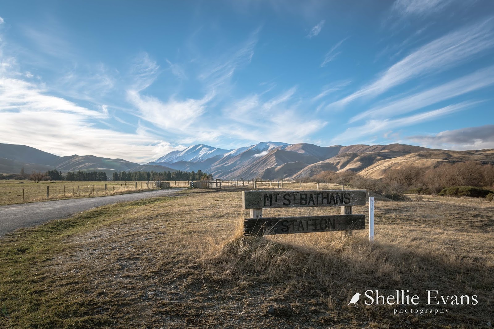
The snow dusted Mt St Bathans is a prominent feature in this quiet back corner of 
Manuherikia Valley.

Further down the road another mob of sheep that belong to a different station are being wintered over in a strip feed paddock. These are hardy merinos and in this light (late afternoon) they certainly blend into their surroundings.


And on another day they still blend in, this time with the soil. The snow covered Hawkdun Range forms a backdrop to the valley.


Present day St Bathans, now part of the Otago Goldfields Park administered by DOC, is a remnant of an old gold mining town originally named Dunstan Creek. The historic Vulcan Hotel is at the centre of the village; it's also for sale if anyone fancies themselves as a publican.

The shamrock on the front facade is a relic from the times of rivalry between the mainly Irish settlers from St Bathans and the Welsh settlers from Cambrian just down the road. The rivalry was known locally as “The War of the Roses” and at one time the acrimony between the villages was quite bitter. In the 1990s the hotel was put into a trust with shares owned by locals who lease out the hotel. There is also purported to be a friendly ghost in Room 1 of the hotel.


Gold was discovered here in 1863 and over 2834 kilos of gold was extracted from the three largest mining operations. By 1864 1000 people lived in Dunstan Creek with a further 1000 in surrounding area including around 50 Chinese miners who lived in caves excavated in the local cliffs.


Dunstan Creek was changed to St Bathans in 1866 after miners requested the original name, given by the first surveyor of the district, be re-instated. By the late 1860s St Bathans was well established with 15 hotels, a number of gambling and dance halls and many businesses. Nowadays the Vulcan Hotel is all that remains of the hotels.

This is one of the most unusual Post Office building I’ve seen in a small town, and rather an imposing one at that. This one opened in 1909 and replaced an earlier small ‘dog box’ that began business in 1864. The building is now owned by DOC.


St Alban of the Martyr Church sits up on a slope overlooking the 'Glory Hole'. The original church blew down in a severe gale in 1870 and it’s replacement met a similar fate in 1883 (the wind must really blow in these parts).


Frederick Dalgety, founder of the stock and station agency Dalgety & Co, and then owner of Hawkdun Station bought the quarter acre section on which the church stood. He then arranged for a new church to be shipped out in sections from Britain, one of the first prefabricated buildings in New Zealand. He imported every item for the church including altar cloths and kneelers. And yet looking at the church and it’s corrugated iron exterior you would swear it was totally kiwi.


It's amazing the things you find when you're walking the streets of a deserted village.


Of course the main subject of my visit was the Blue Lake. Before gold was discovered at St Bathans in 1863, the 120 metre high Kildare Hill stood where the Blue Lake is now located. 


The hill was named after their home country by the Irishmen who made the original find. Sluicing whittled the hill down to become first the Kildare Basin, and as it sunk further it became known as the Glory Hole, celebrating the riches it yielded.


The Kildare Hill Claim became the site of the deepest hydraulic elevating operation in the world, an operation that would eventually turn a 120 metre hill into a 68 metre hole over 800 metres long. 


The hydraulic elevator acted like a giant vacuum cleaner, sucking water and gravel out of the pit to where it could be worked for gold.


Mining was halted in 1934 because the sides of the pit were getting too close to the town and once abandoned, the Glory Hole filled with water that became a striking blue colour, due to the high mineral content of the surrounding tailings. Hence today’s Blue Lake. Although much of the colour has been lost now that the minerals aren't leeching quite so bad.


And when there's not a whisper of a breeze, the water's still and the right light catches the clay cliffs, the golden reeds and grasses and the bare trees, the lake provides perfect mirror reflections; one of my favourite photographic genres.


These photos were taken on the first evening when I thought I'd just drive up and reacquaint myself with the lake and just maybe the conditions might be right. And how right they turned out to be. On arrival there was a gentle breeze, if you look at the photo at the beginning of the blog you can see the slightly ruffled water.


I took a few shots from the top of the cliff near the carpark and then drove down to the lake edge and from there watched as the breeze departed and the lake became a millpond.


I quickly drove back up to the top and hurried along the path that winds it's way in and out of the tailings to the far end of the lake. And because I knew from previous visits where the best spots were to catch the reflections, I was able take a few short cuts right to the edge of the cliffs which involved in some cases, carefully climbing a slippery slope of wet tailings. Luckily I was wearing gumboots as anything off the gravel path was either a muddy bog or thick gluggy clay. 


I had to hurry from one spot to the next as the sun dropped behind the mountain range and the light began to fade.


Eventually I gave up on the chase and headed back to the carpark, stopping in the middle of the narrow stream that rushes down the edge of the reserve. No matter how hard I tried I could not budge the clay, in the end I had to rip some leaves off the Lamb's Ear and scrape the sticky stuff off, my hands immersed in the freezing water. 

As I headed back up the path I caught sight of one of the buildings in the village catching the last of the winter sunshine. What I love about this photo is the fact that this cute little cottage is in fact the side profile of the second storey of the post office!


Later on as the temperature took a tumble, the clouds  provided the perfect backdrop for a brilliant sunset.


August 20, 2017

World Famous in New Zealand- Canterbury

Catch-up
There & Back- Mt Somers to...

I'm about to take you on a quick a tour along the inland road through mid-Canterbury. As mentioned earlier our first stop was at Mt Somers where they have a very cool general store.


We stayed at the Mt Somers Holiday Park while we explored the Ashburton Lakes area; we'd decided we'd have power whenever the opportunity presented itself during the next couple of weeks. Sometimes in winter you just want to be able to flick a switch without the worries of watching the solar or running the generator.  The ground was soft from all the recent rain but we were able to park in another area, between cabins, which was a lot firmer. It's a very quiet time of the year for everyone in the village; I think we saw just one campervan during our stay.


The Holiday Park was next door to the Domain where there's also a camping area (with power & soft ground too); we'd already decided to support a local business, and not that the money mattered, the Holiday Park was just $7 dearer. The Domain also has a small museum and next door the old Mt Somers Musterers/Trampers Hut which was shifted to the Domain when DOC build a new hut on the Mt Somers Walkway. It's kitted out with pre 1960s farming and tramping gear.


Of course I did a little tiki-tour around the village taking photos and adding a couple more churches to my collection (one of them at the bottom left, above ) and an old farm homestead now a barn; and looking very much like one of our old farm barns. 

But this work-of-art (below) must take the prize for the most creative and unusual hedge I've ever seen. Imagine the work that goes into keeping that in shape. I found this from a Stuff article while researching-

I follow the trimmed arrows to the door of the designer, who describes it as a gardening whimsy.
He does not want to give his name, but the hedge hides an impressive garden.
"It was a boring piece of hedge to cut every six months, so I thought I'd try to make it interesting," he says. "If I was going to do it again, I think I'd be a bit more adventurous."
The hedge has become an attraction in Mt Somers.
"If I had a dollar for everyone who has stopped to take a photo I'd be a rich man."

That's one more dollar not in his pocket...


On my way to Mt Hutt a couple of days earlier I stopped at Staveley and Alfred Forest to take photos in the village including the old Staveley School in front of Mt Somers, the church, hall and old dairy factory. At Alfred Forest I found more sculptured moa beside their hall, similar to the ones I saw at Moa Flat.


Staveley is world famous in New Zealand- Lynda Topp, one half of the much-loved musical and comic duo, The Topp Twins, has a lodge & bar/cafe in the tiny village. The Lodge is just past the church in the photo above and just a few metres from Staveley Store, the old general store which is now a cafe & farm store and is owned and run by Mt Somers Station. 


And not by Lynda Topp as you may have thought if you spotted the ute parked outside! No, Lynda must have been inside having a coffee (her cafe is shut over winter). I didn't go in to check, I was star-struck just seeing her vehicle. And I didn't want to dawdle, I had Mt Hutt to traverse! 


But I really was star-struck the next day when we stopped in at the cafe for morning tea on our way north and who should arrive not long after? Lynda Topp of course! So I surreptitiously took a photo of her while pretending to take one of David eating. I then cut him out of it! I suppose I should have said hello but I was a little shy (yep, that's me) and I also didn't want to intrude.


The next camp site I had in mind was the Rakaia Gorge Camping Ground ($8.50pp, children free) which is on a stunning site, right on the edge overlooking the Rakaia River.


It's a large landscaped  area with plenty of grassed sheltered alcoves for camping in but unfortunately all but the area beside the road was closed off for winter. And once again the photos do not tell the whole story; it's freezing cold with a bitter wind blowing and much of the area that is available has boggy ground and muddy tracks through it, with a heavy frost still laying on the ground in the shade. 

And along with that there's the traffic noise and passing motorists are calling in to use the public toilets, just enough negatives for us to decided to give it a miss and carry on up the road. I really wanted that river view so we'll have to return in the summer. 


We stopped next at Glentunnel and had a look at the holiday park there but it was in the shade down in a dip beside a river and didn't look that inviting. Some days things just don't feel right or go well. Usually there'd be nothing wrong with these places but when you having a bad day travelling, you're having a bad day.

We carried on to Sheffield, checked out a CAP parking site there, which didn't appeal either, and then cheered ourselves up by having a pie for lunch from the famous Sheffield Pie Shop. As I walked to the shop I took a cellphone photo just as a head popped out the door. I said when I stepped inside, 'I took a photo of the baker then?'  The lady said excitedly "No and you're Shellie! I saw your rig go past and I said to the others, I wonder if that's Shellie who has a blog and posts photos on Facebook, I show them to my husband every night!' So it's not just the pies that are famous in Sheffield! 


Our next stop is Springfield- famous for it's 6 tonne Simpson's doughnut- where we check out yet another Domain campground. We're wanting power but it's wet, boggy and in the shade where the power points are so we hit the road again. We head back down the road, back through Sheffield and turn north. At this rate we'll be popping out the end of the inland road well in advance of our intended two weeks exploring the high country.


We cross over the Waimakariri River, another one of the wide braided Canterbury rivers...


...pass through Oxford and head to a camping ground just out of town, one that's been on my radar for awhile.


Ashley Gorge Holiday Park is a very popular camping ground....in the summer. In the winter it's a very deserted camp. Probably because it's tucked into a narrow valley and is in the shade all day! 


Three days of frost was still on the ground when we arrived (the rain washed that away overnight), it was absolutely freezing but we'd been travelling all day and we didn't want to go any further. So we cranked up the diesel heaters, drew the blinds and settled in for the night; we'd head off again in the morning.

Perhaps had we seen this sign just outside the camp before we went in we may have just carried on!


The next day dawned cold, wet and miserable so we decided to dig in and have another day at Ashley Gorge. There was no point shifting, it was going to be cold, wet and miserable everywhere. We wrapped up warm and did the short walk to the back of the camp to check out the gorge and back along the river to road bridge before heading back to the van. It was just too cold to be outdoors.


There was another reason I wanted to stop in Oxford. I wanted to meet a famous Little Owl named Oscar who lives at Oxford Bird Rescue. I have been following Oscar on OBR's Facebook page for a very long time and was looking forward to saying hello. Oscar is an ambassador for all his feathered friends, he is blind and spends a lot of his time visiting schools and other groups encouraging conservation. 

Little Owls are not endemic to NZ but have naturalised after being introduced from Germany in the early 1900s. They are only found in the South Island and very common in the drier open eastern areas of the island, preferring open pastureland and hedgerows to native bush. Unlike our endemic owl the Morepork/Ruru, Little Owls are often active during the day as well as the night. We've yet to see one in the wild but there are quite a lot of them in Christchurch's Hagley Park and around the Sumner cliffs.


We left Ashley Gorge the next day and headed north once again, off towards Rangiora, Rangiora on the outskirts of Christchurch! Twenty kilometers later we pulled to a grinding halt. Neither of us wanted to return to Christchurch just yet. We tossed a few ideas around, and dismissed most of them for various reasons (this is very unusual as we usually have a destination in mind before we pull out). 

In the end we decided to turn around and head back towards Oxford, back over the Waimakariri, back through Glentunnel, back past the Rakaia camp and we hang a left opposite Mt Hutt Station. And that is how we found ourselves back in Methven waiting for  a snow storm to arrive in a couple of days.


And this time we stay put for over a week, relaxing and enjoying a friendly camp and village.


October 08, 2016

Beach Hop South- Akitio & Pongaroa

Real-time

Our next destination is Akitio Beach but before turning onto Route 52 we took a short detour up the road to Weber so I could photograph the church. Weber is another small farming community similar to many that we've passed through on our way south;  a handful of houses, a rugby field & hall, a school, a war memorial and a church and that's life in a small country settlement. There's also what looks to have once been the hotel that's now a private residence.


We turn around and head back to Route 52. Route 52, once a state highway (SH52), is a meandering 200km rural country road that links Waipukurau to Masterton. It is the only road access to many of the large hill country farms along the east coast. Nowadays it is also 'sold' as one of the cycling routes on the NZ Cycle Trails.

There are many farm ponds and dams along the road and as we pass I'm always scanning for waterfowl- various species of ducks, NZ scaups, black swans, pukekos, the ever present turkeys, pied stilts and spur-wing plovers are common. On a few occasions I've also spied a pair of tiny NZ Dabchicks/Weweia- these are also known as NZ Grebe and are a relative to my favourite Australasian Crested Grebes which are only found in the South Island. Dabchicks also carry their chicks on their backs like the Crested Grebe (see the link above for my photos from last summer). 

This pond was close to the road and I managed to sneak up the Dabchicks before they saw me and took off.


We're now in the Wairarapa where the pea weevil was discovered back in July. All commercial and home gardeners are banned from growing peas or moving pea plant material out of the area for the next two years in a bid to rid the area of the nasty pest that's threatening the livelihood of many NZ pea crop farmers. 

Commercial crops, worth about $15 million to the local economy, were grown by around 120 pea farms in the area so it will be a huge loss to the Wairarapa region. Not dissimilar to the PSA threat which kiwifruit growers had to contend with. I wondered if Sweet Peas were part of the ban, but apparently not.


The weather was fast deteriorating on our way south and we tossed up whether to head out to Akitio Beach or carry on further down the coast. It's 30km to Akitio from Route 52 and while there is a loop road, part of that was gravel which usually wouldn't be an issue, but as David had just cleaned the vehicles he wasn't keen on getting them dirty again that quick. So it was going to be there and back on the same road.

Akitio was deserted with not a soul in sight other than one lonely fisherman way out on the sand bar beside the river mouth. 


We drove to the campground (there's no freedom camping beach side), it was quite a small camp and with the weather as it was and just starting to rain, it didn't look too inviting. We turned around and drove back along the beachfront, parking on the reserve in front of the baches to have lunch and decide what to do.


I loved this busy cottage we parked near, with all it's plants, pots, knick-knacks and flotsam, it looks like permanent residents live here.


There's no shortage of driftwood at Akitio.


Even the huge sand bar separating the river from the sea was covered in wood. There must be some very rough seas along this coast and many logs and trees washed down the river.


After lunch we decided to head back to Route 52 and stop in Pongaroa for the night. I'm sure if the sun was shining and the weather was more conducive we'd have stopped for a night but we were both happy to keep moving. 

On the way out we stopped near the bridge over the river so I could take a photo of this gorgeous homestead. This belongs to Marainanga Station, and it's for sale if anyone is interested.


I'd visited Akitio with some friends as a teenager, we'd stayed with the brother of one friend on Akitio Station (he was a shepherd). All I have is the memory of driving forever (from Napier) to get to Akitio, so I was keen to see if I could recall anything of the beach. Nope. Nothing. I also have a girlfriend whose parents farmed near Pongaroa and she tells me we visited Akitio too. It still didn't ring any bells. 

Close to the river bridge there were three large homesteads and one woolshed on view, the other sheds were tucked down the back of the drives. I'm not too sure which station the woolshed and the homestead on the left belong to but the one of the right is Akitio Station Homestead.


We stop for a photo beside the very impressive sculpture, made from railway sleepers, at the entrance to Akitio Station.


And then carry on back along the same road, winding our way through the same scenery and farms, passing the same sheep and same farmers still in their yards docking and sorting their flocks. Farmers who must be thinking "I'm sure we just saw that going the other way an hour or so ago". A sixty kilometre detour is nothing to us tiki-tourers.

There's a lovely dump-station in Pongaroa (can you have a lovely dump-station?) - it's not something you expect to find out in the back-blocks but very much appreciated all the same. We empty all our tanks and fill with fresh water and then head to...


...the Pongaroa Domain, where it's just us and the birds for the night. 


A small donation is required if you are staying and it's $10 extra a night for power and access to the toilets & a shower- there's a small ensuite beside the club rooms. The camping area overlooks the Pongaroa Domain and rugby field where I'm sure there has been many a great match over the years- today there are only sheep & their lambs. I was told by one of the residents, that back when he was a lad (and I'd say he was pushing 90), Pongaroa had four rugby teams made up of mainly station hands. And that one of the farm stations reached from here to the coast!


We decided to plug into the power and give the van a boost, the only problem being the slope we had to park on to reach the power plug. I think it's the first time ever I've been able to walk beneath the nose without ducking! We did look a little strange bow high but I'm sure the only person who noticed was David.


On the other side of the row of pine trees behind us were more sheep and their lambs- I found these two little cuties keeping warm in their wooly jumpers and nibbling on the grasses. Their mum nowhere in sight when they spotted me, they took off over the brow looking for her. 


I thoroughly enjoyed our short stay at the Domain, I'd have to say that the variety of birds in the tiny area was amazing. A number of tui were visiting, and chasing each other out of the small kowhai tree beside the van...


...half a dozen hefty Kereru/NZ Woodpigeons were defying gravity and doing acrobatics in the nearby tree lucerne...


...a Scared Kingfisher/Kotere was using the fence posts as a launching pad to collect grasshoppers and other bugs out of the grass beside the carpark. A Spur-wing Plover pair and their two chicks were feeding on the rugby field and letting everyone know of my whereabouts as I crept about trying to get a few good shots. 

Half a dozen rooks roosted in the pines nearby and a dozen swallows swooped and dived around the clubrooms. I also saw a pair of reasonably rare kakariki/NZ Parakeet fly by. And the best sighting of all was a first for the season; a Shining Cuckoo/pÄ«pÄ«wharauroa who most people only hear but never see (super zoom shot on the bottom right, but evidence all the same!). They have only just flown back in from the Pacific Islands for the breeding season- watch out Grey Warblers, your nests will be invaded very soon.


It has been lovely to see how many Kowhai trees there are scattered about the farmland, along streambeds and through the bush on our travels south. And they're all flowering at the moment so there are brilliant splashes of yellow across the landscape. It's unusual to have such a bright NZ native tree and of course they're supplying lots of food to our nectar loving native birds and honey bees.


Before we left Pongaroa later the next morning, I shot out in the ute to take my church photos and check the little village out. This church is now a pre-school and as I maneuvered to get a better shot these two pet lambs gave me away by baaing loudly and racing up and down the fence line looking for a feed.


It was while I was taking photos of some of the historic buildings around the village that I met my 90 year old local man and his huge, big fat cat; they came out to the gate across the road from the Our Lady of the Rosary church. He told me he'd lived in Pongaroa all his life and things just weren't the same anymore. And did I know that the railway was once coming to Pongaroa from Masterton and if it had, it would be a bustling country town similar to and replacing Pahiatua.


He followed me down the road, chatting away, as I took a photo of the Puketoi Lodge, for the Historic Places Trust...


...and then told me not to miss the memorial to Pongaroa's most famous son and Nobel prize winner, Maurice Wilkins. I had wondered what on earth the unusual sculpture of three stones on the corner of the main street were for (click photo to enlarge).


When I asked him if he might know my girlfriend's parents who used to live nearby, my lovely old gentleman farmer told me, that as a volunteer fireman, he had been involved in rescuing Joe from the back of the farm after a farm bike accident. It certainly is a small world.

He also didn't forget to tell me that the big pile of burnt rubble and timber on the corner opposite the three stones used to be the general store and had only recently been razed to the ground under very suspicious circumstances. It was also rumoured there was $10,000 of jewels lost in the ashes. Small town talk is still alive and kicking.

Other than the pub the rest of these Pongaroa buildings were empty. The grand concrete entrance is to some long forgotten park.


Our next stop is Masterton 90kms away, to fuel up and buy a few groceries before we head to our next beach Castlepoint. There are no fuel pumps in Pongaroa and we haven't seen many since leaving Napier. When David asks the rural postie, who is checking his phone beside the dump station, he tells David a local farmer will happily 'see you right' if you're in a jam. We'll be fine, but what a friendly bunch of people we're meeting on our travels.

The map is getting very cluttered- you can access the actual map by clicking on the little square box on the right at the top- hover over it and it will say 'View larger map', then click to open.