There’s a range of options available to walk the Abel Tasman National Park Great Walk. The whole track can be walked as a multi-day(3-4) tramp staying in DOC huts overnight along the way or in your tent if you have carried it with you. Or there are multiple day walk options available where you select the section of the track you’d like to walk and then catch a tour or a water taxi to the start of that section, walk it and catch a water taxi home.
We decided on a tour with Abel Tasman Sea Shuttles and to do the walk from Medlands Bay to Anchorage, an 11.5km walk that included a number of points of interest along the way. Before we were dropped off at Medlands Bay, the tour took us up to Totaranui, which is the furthest north the tour boats go and nearly to the top edge of the park.
Along with seven walkers, & four people on the boat for just the tour, there were eight overseas tourists doing a kayak/walk combination. Their kayaks were loaded in the back of the catamaran and we off-loaded them not too long after, at Apple Tree Bay, one of the first big bays in the park.
Our boat tour started with a visit to the Adele Island seal colony. Of course we had already seen the seals when we visited in our dinghy a week or so ago but it didn’t matter, I can never get enough of seals & especially seal pups of which there were quite a few on this visit (with their funny faces) . Most of the adults were out fishing & the pups were out sunning themselves and playing in the water. Looking back towards Kaiteriteri as we crossed Astrolabe Roadstead to the island I could see that there was snow atop Hoary Head (Mt Campbell to the left) which are both in the Kahurangi National Park.
Further on into the park, it was a surprise to see many holidays homes dotted along the bays and in the bush. Even though this is a national park there are quite a few areas that are still privately owned. These are only able to be accessed by water and now it makes sense that there is a sea barge permanently moored in our little bay; its how supplies are transported to these houses. I’ve seen various household goods being loaded on the barge while we’ve been parked at Kaiteriteri including beds, mattresses and a kitchen sink!
Just yesterday we watched as three Devan tanks were loaded onto the barge. Now that brought back memories. Today they came back on the barge with a "Pete's Takeaways" truck full of ........ unmentionable stuff. They must be cleaning out the septic tanks somewhere up the line.
As we passed through Torrent Bay the skipper pointed us in the direction of the entrance to the estuary and told us to take note of where we were in the boat; quite close to the beach. Because the next time we would see this bay the tide would be out, the estuary empty and the bay totally exposed. The tidal range on the Abel Tasman coast is one of NZ’s largest and can be up to 5 metres (around 15 feet).
The sculptured granite Tonga Arches are one of the highlights of the coastline and a destination for kayakers and tour boats. A few weddings have also taken place in the largest arch- at low tide I hope! Approaching the headland, it looks like any other along the coast.
But as we move in closer the arches are revealed.
Must have been a small wedding party….…..in fact the wedding takes place out on the exposed sand (at low tide) in front of the biggest arch.
We passed many Spotted Shag rookeries along the way, many of them perched on near vertical rock faces like the ones we saw on Adele Island from our dinghy.
Large granite boulders and rocky headlands separate each of the many golden sand bays that make up the park but this one was a whopper! It looked like a rock in waiting, waiting to be Spilt Apple Rock II.
“I’m the king of the castle” says the Black Backed Gull atop the cairn someone had left on the boulder.
Totaranui Beach DOC camp was our turn-a-round point on the tour. The camp at Totaranui is DOC’s largest & most popular camp in NZ and can hold over 800 people at the height of the summer season. It is accessed from Takaka via a very winding & narrow gravel road. It sounds a lot like the road to Port Jackson on the Coromandel in the North Island.
It’s also one of only a few DOC camps that are not on our DOC camp pass. Once we move over to Golden Bay we are hoping to stay at the camp for a few days(or do a day trip if we can't get the van there) so it was great to see the area, if only from the water. There is also a large estuary at the far right end of the beach and a few more day walks that can be done from this end.
Our next stop after turning around and heading back down the coast was our drop off point, Medlands Bay, a tiny little sheltered cove in the corner of the bigger Bark Bay. All seven hikers aboard were doing this section of the walk, as we disembarked two of our fellow walkers had already removed their boots & rushed down to the water to have a paddle & splash about. Obviously pleased to have arrived in this little piece of paradise, even if the water was ice cold!
To be continued…….Part 2
Tiki Tour - New Zealand slang
1. a sight-seeing journey with no particular destination in mind.
2. taking the scenic route to a destination.
3. to wander aimlessly.
Showing posts with label head. Show all posts
August 12, 2014
Abel Tasman Walk- Part 1: The Boat Trip
Labels:
anchorage,
arch,
arches,
bay,
beach,
great walk,
head,
hoary,
island,
kaiteriteri,
kayak,
medlands,
national,
park,
Tasman/Nelson,
tonga,
torrent,
totaranui
June 16, 2014
Baldwin & the Mole, Dunedin
After 4 days of dreary weather the rain finally stopped and we decided to do a little tiki-touring before it returned. It was overcast and bitterly cold but at least it was dry. We’d already decided not to “do” Otago Peninsula on this trip, we’d be back & we really wanted to explore the peninsula, renowned for its wildlife, during spring, summer or maybe even autumn when there was going to be more nature activity and when it was also drier. So we followed the road up the other side of Otago Harbour, the north side, heading for the Mole at Aramoana.
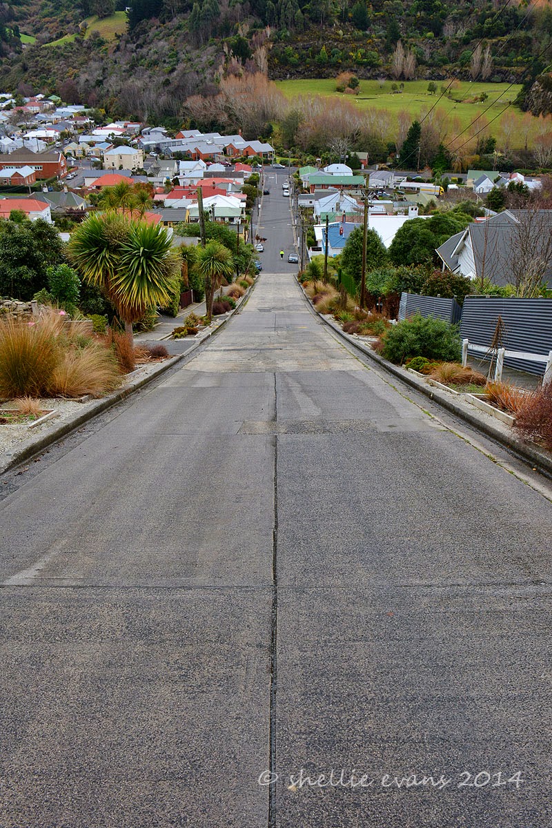
But not before a slight diversion to the steepest street in the world (according to the Guinness Book of Records), Baldwin Street is 161 metres long and climbs a vertical height of 47.22 metres which is an average gradient of 1 in 3.41. At it’s steepest section the gradient is 1 in 2.86. It looks very deceptive from the bottom but once you start the climb you’re made very aware of how steep it actually is.
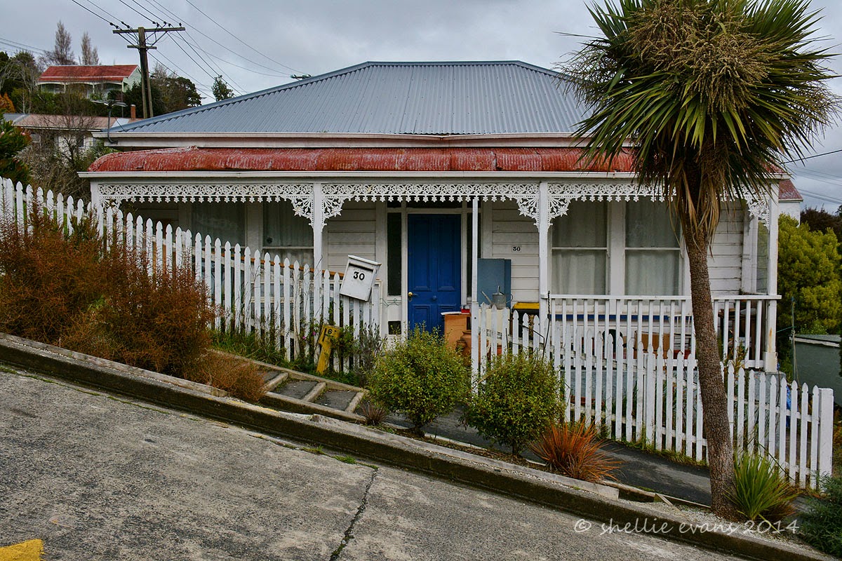
I loved the old single story houses on the road, they really gave an indication of how steep the street is with their sides disappearing into the hillside. I also smiled at the “No Junk Mail” stickers, especially at the top. Poor posties, you’d think that if they had to walk this road everyday then at least the residents could accept a few pieces of junk mail.
Half way up I managed to waylay a local for a bit of a chit-chat for a good 5 minutes while I secretly recovered my breath. And if you look closely at the cars down in the valley you’ll see a familiar face sitting in a Ford ute reading his iPad paper, piker!
The prize at the top; a much appreciated water fountain & a seat to rest the shaking legs. And darn. I forgot the Jaffas!
We followed the road on up the valley from Baldwin Street then turned sharply at the Upper Junction dropping quickly down to Roseneath on the harbours edge. This was the view from the top looking out towards the entrance and across the water to Taiaroa Head on the tip of Otago Peninsula.
We had a quick drive through the wharf area at Port Chalmers but it was just too cold & windy to linger and our tummies were starting to grumble. We stopped just around the corner from the Port at Carey’s Bay Hotel (built in 1847), in Carey’s Bay (surprise, surprise) for lunch, enjoying the warmth of roaring fire while we had Blue Cod (for him) and Seafood Chowder (for me), both of which we thoroughly enjoyed.
We also enjoyed the company of a delightful older couple who arrived just after us but had the window table reserved so had the best seat in the house. They told us they come to the restaurant regularly and always have the window seat, they obviously make a occasion of it as they ordered up large, both wine & food. Although you’d think that as they come so often the lady would know what she might like to eat & what was on the menu. She just couldn’t decide on what to have and sent the waitress away a couple of times while she dithered further. In the end she ordered salmon but I have the feeling it was still a spur of the moment choice, because as the waitress walked away. she whispered to her husband “I had that last time, didn’t I? Oh well…..”
Suitably replete, we continued on around the harbour’s edge. The road is very narrow in places and falls off a sharp edge into the water, being high tide it felt like we were about to drive into the harbour in some places, the corners are very tight. Along the way I spotted a shag on one of the beacons that looked unfamiliar, it had a pure white front and white wing strip.
We turned around and crawled back slowly along the road, stopping just short of the beacon. A Little Black Shag was poised to fly but it was the one underneath that we were keen to see up close. I grabbed a couple of shots (still too far away to get a good close-up) but good enough to identify when we got home. It turned out to be a Stewart Island Shag (Kawau), found only in southern New Zealand & with a population of fewer than 5000 birds. Another bird I can add to my Twitchers list!
Finally after a long & winding 27kms, we arrived at the very end of the harbour & the Aramoana Mole. The Mole is a 1200 metre long man made breakwater that keeps the main channel clear of silt & sand. There’s also 5 ships that have been scuttled along the length of the Mole adding to the breakwater & making suitable diving wrecks too. I walked a short way along the breakwater but the icy wind was whipping through making it quite unbearable so I quickly returned to the warm ute where David was waiting for me (he’s not silly).
Across the harbour was the lighthouse on Taiaroa Head, I looked to see if I could see any albatross soaring on the thermals but no such luck. They will just have to wait until we return.
Tucked into the sand dunes near the Mole, and with no obvious sign that it is there, is a memorial to the victims of New Zealand’s worst mass shooting & most horrific crime. Twenty four years ago this tiny sleepy seaside village was ripped apart when David Gray went on a murderous 24 hour rampage shooting dead 13 people, including children and the local police sergeant. I am sure many New Zealanders can remember exactly where they were or what they were doing as the event unfolded. A bit like knowing where you were when JFK was assassinated. I was visiting Napier & was shopping in Taradale when I heard the news on the car radio. I was so upset that I went to a phone box (no mobile phones then) and called David in Tauranga to get some comfort & hear a familiar voice.
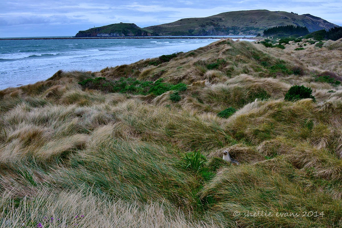
We drive to the north end of beach and climb to the top of sand dunes, the wind is still blowing fiercely on shore and look who we disturb from his slumber, sheltering in the dunes.
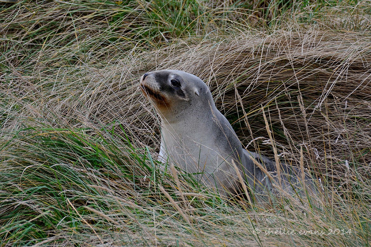
A very well camouflaged NZ Sealion (Whakahao), he’s been sleeping for awhile as he’s bone dry & blends into the sand tussock very well.
He also looks very comical with his “chocolate” lips- must be the fish oil that has stained his mouth.
He decides to investigate us further and making hard work of it, slithers & slides through the grass towards us, climbing up a bank before deciding that’s too much like hard work and rolling back down into the dip where he promptly goes back to sleep.
Another car arrives in the carpark and the lone occupant makes his way down the track to the beach before heading north on a walk. The Keyhole Rock towers above him. I imagine his surprise if he came across our sealion on the track. The long sand tussock would cover a sleeping sealion quite easily. I wonder who would get the biggest fright.
We decide to head for home before it gets any colder and along the road we catch up to the dredging ship that was near the Mole when we arrived. The channel must run very close to the edge of the harbour here as the ship looked huge. I’d love to see the cruise ships arriving, they would tower over the roadway and I bet the passengers would get an impressive view of the countryside.
This little cottage amazed me, located on a tiny ribbon of land tucked between the harbour & the road. And being renovated by the look of it too. I’m not sure I’d like the traffic whizzing by so close & at quite a speed and I wonder about the waves when the wind gets up.
But not before a slight diversion to the steepest street in the world (according to the Guinness Book of Records), Baldwin Street is 161 metres long and climbs a vertical height of 47.22 metres which is an average gradient of 1 in 3.41. At it’s steepest section the gradient is 1 in 2.86. It looks very deceptive from the bottom but once you start the climb you’re made very aware of how steep it actually is.
I loved the old single story houses on the road, they really gave an indication of how steep the street is with their sides disappearing into the hillside. I also smiled at the “No Junk Mail” stickers, especially at the top. Poor posties, you’d think that if they had to walk this road everyday then at least the residents could accept a few pieces of junk mail.
Half way up I managed to waylay a local for a bit of a chit-chat for a good 5 minutes while I secretly recovered my breath. And if you look closely at the cars down in the valley you’ll see a familiar face sitting in a Ford ute reading his iPad paper, piker!
The prize at the top; a much appreciated water fountain & a seat to rest the shaking legs. And darn. I forgot the Jaffas!
We followed the road on up the valley from Baldwin Street then turned sharply at the Upper Junction dropping quickly down to Roseneath on the harbours edge. This was the view from the top looking out towards the entrance and across the water to Taiaroa Head on the tip of Otago Peninsula.
We had a quick drive through the wharf area at Port Chalmers but it was just too cold & windy to linger and our tummies were starting to grumble. We stopped just around the corner from the Port at Carey’s Bay Hotel (built in 1847), in Carey’s Bay (surprise, surprise) for lunch, enjoying the warmth of roaring fire while we had Blue Cod (for him) and Seafood Chowder (for me), both of which we thoroughly enjoyed.
We also enjoyed the company of a delightful older couple who arrived just after us but had the window table reserved so had the best seat in the house. They told us they come to the restaurant regularly and always have the window seat, they obviously make a occasion of it as they ordered up large, both wine & food. Although you’d think that as they come so often the lady would know what she might like to eat & what was on the menu. She just couldn’t decide on what to have and sent the waitress away a couple of times while she dithered further. In the end she ordered salmon but I have the feeling it was still a spur of the moment choice, because as the waitress walked away. she whispered to her husband “I had that last time, didn’t I? Oh well…..”
Suitably replete, we continued on around the harbour’s edge. The road is very narrow in places and falls off a sharp edge into the water, being high tide it felt like we were about to drive into the harbour in some places, the corners are very tight. Along the way I spotted a shag on one of the beacons that looked unfamiliar, it had a pure white front and white wing strip.
We turned around and crawled back slowly along the road, stopping just short of the beacon. A Little Black Shag was poised to fly but it was the one underneath that we were keen to see up close. I grabbed a couple of shots (still too far away to get a good close-up) but good enough to identify when we got home. It turned out to be a Stewart Island Shag (Kawau), found only in southern New Zealand & with a population of fewer than 5000 birds. Another bird I can add to my Twitchers list!
Finally after a long & winding 27kms, we arrived at the very end of the harbour & the Aramoana Mole. The Mole is a 1200 metre long man made breakwater that keeps the main channel clear of silt & sand. There’s also 5 ships that have been scuttled along the length of the Mole adding to the breakwater & making suitable diving wrecks too. I walked a short way along the breakwater but the icy wind was whipping through making it quite unbearable so I quickly returned to the warm ute where David was waiting for me (he’s not silly).
Across the harbour was the lighthouse on Taiaroa Head, I looked to see if I could see any albatross soaring on the thermals but no such luck. They will just have to wait until we return.
Tucked into the sand dunes near the Mole, and with no obvious sign that it is there, is a memorial to the victims of New Zealand’s worst mass shooting & most horrific crime. Twenty four years ago this tiny sleepy seaside village was ripped apart when David Gray went on a murderous 24 hour rampage shooting dead 13 people, including children and the local police sergeant. I am sure many New Zealanders can remember exactly where they were or what they were doing as the event unfolded. A bit like knowing where you were when JFK was assassinated. I was visiting Napier & was shopping in Taradale when I heard the news on the car radio. I was so upset that I went to a phone box (no mobile phones then) and called David in Tauranga to get some comfort & hear a familiar voice.
We drive to the north end of beach and climb to the top of sand dunes, the wind is still blowing fiercely on shore and look who we disturb from his slumber, sheltering in the dunes.
A very well camouflaged NZ Sealion (Whakahao), he’s been sleeping for awhile as he’s bone dry & blends into the sand tussock very well.
He also looks very comical with his “chocolate” lips- must be the fish oil that has stained his mouth.
He decides to investigate us further and making hard work of it, slithers & slides through the grass towards us, climbing up a bank before deciding that’s too much like hard work and rolling back down into the dip where he promptly goes back to sleep.
Another car arrives in the carpark and the lone occupant makes his way down the track to the beach before heading north on a walk. The Keyhole Rock towers above him. I imagine his surprise if he came across our sealion on the track. The long sand tussock would cover a sleeping sealion quite easily. I wonder who would get the biggest fright.
We decide to head for home before it gets any colder and along the road we catch up to the dredging ship that was near the Mole when we arrived. The channel must run very close to the edge of the harbour here as the ship looked huge. I’d love to see the cruise ships arriving, they would tower over the roadway and I bet the passengers would get an impressive view of the countryside.
This little cottage amazed me, located on a tiny ribbon of land tucked between the harbour & the road. And being renovated by the look of it too. I’m not sure I’d like the traffic whizzing by so close & at quite a speed and I wonder about the waves when the wind gets up.
Labels:
aramoana,
Baldwin. street,
Bird,
careys bay,
chalmers,
Day Trip,
Dunedin,
harbour,
head,
keyhole,
lighthouse,
memorial,
mole,
Otago,
port,
sealion,
shag,
steepest,
taiaroa,
world
Subscribe to:
Posts (Atom)