Showing posts with label kayak. Show all posts

Sunday, September 10

Snow at Hanmer Springs

Catch-up

From Christchurch we made our way north to the NZMCA Park at Hanmer Springs- parking in our preferred 'secret' spot, up on the old road that passes through the site- less traffic noise, solid ground and a view. 


This must be our 4th or 5th visit to Hanmer so we don't have too much exploring to do but I did take a walk down the Hanmer River (which passes the rear of the park) to where it exits into the Waiau River. From there I was able to get a river bed view of the historic Waiau Ferry Bridge; a one way bridge and the only way into Hanmer. I waited for the jet boat to return- it takes tourists up the Waiau River- but gave up after 15 minutes or so. 


With snow once again forecast we decided to stay put for a few days before tackling Lewis Pass, the new alternative route between Picton & Christchurch. For my overseas readers, the alternative route is a 480km, 7-8 hour 'detour' caused by the November 14th Kaikoura earthquake which damaged the main State Highway along the coast- a route that took about 3hours. 


We had  a few neighbours overnight, and now you can see why we park up on the road, especially in winter!


And right on schedule (although not as much as I'd hoped for) the snow arrived overnight.


We'd left the flexi buckets out overnight after collecting water off the roof when it rained the previous afternoon...


...which was not a good idea, there was a thick layer of ice over the top which we had to break up to get to the water underneath.


It's the busiest we've seen the Hanmer Park, even in the summer. The alternate route passes Hanmer, so it's become a very convenient overnight stop for NZMCA members.


The day before the snow arrived we did a tiki-tour over Jacks Pass (at the back of Hanmer) and down to the Clarence River. We've explored the road in both directions a few times before but not when there has been snow about. 


We've been up to Lake Tennyson and come in from St Arnaud on the Rainbow Road so today we turned right following the river along the Molesworth Road which leads to the Molesworth Station and through to Blenheim at the other end. And that's a road half closed sign- it means the road is closed somewhere further on but not right here. Yes. Seriously. You learn these things after awhile. It also stops Joe Blog explorer/tourist from venturing any further, he's too scared. Which in turn means if it is really closed then no one will have to come rescue him when he tries to go off road in his 2WD rental through the snow.


The scenery was once again stunning. Blue sky ahead...


...and dark clouds looming behind.


A few kilometres down the road we spotted a car backed in off the road and two guys taking their kayaks off the roof.  Kayaks is not what you expect to see in the middle of a snow covered landscape!


But they were the reason I then found myself following David up the road in a random vehicle! The guys talked us into taking their car and trailer 10 kms up the road to where they'd haul out after kayaking down the Clarence.


It saved them driving their car to their exit point and then biking back to the kayaks. One of them said to his mate "See, I told you someone would come along, o ye of little faith!" 


It suited me just fine! I  was able to stop and take a few photos along the way.


Hmm.....now where did David go? 


Oh there you are! Waiting for me a a gate and wondering if this was where they wanted us to leave their car. 


We checked the river and decided there was no way they could haul their kayaks out of the narrow gorge below us, so we carried on.


Until we got to the Clarence River Bridge. This is near the confluence of the Clarence & Acheron Rivers, the historic Acheron Accomodation House and the road proper through Molesworth Station.


I waited until David walked out on the bridge to get a shot...
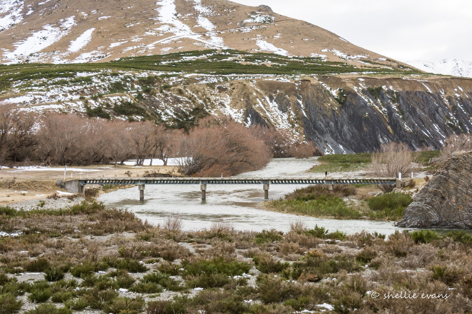

...and then carried on to pick him up at what happens to also be the boundary between Canterbury and Marlborough. Unfortunately, this is as far as we'll go today, there's locked chain across the bridge and I suspect there's a locked gate further on. We haven't driven the Molesworth road yet (it's closed over winter) but we've planned twice before and both times we had to abandon the trip; the first time the road was closed due to high fire risk and the second time the Kaikoura earthquake foiled our attempt. Maybe we'll get it done this summer when it reopens at the end of October.


We left the kayaker's car at the bridge and headed back along the road craning our necks to see if we could spot them everytime the river came into view. 


It was a fluke that we saw them when we did, from an area high above the river where we could watch them approaching...


...and then paddle through the riffles and off round the bend at the far end. David called to them as they went past to let them know the car was waiting for them at the bridge. Job done.


We carried on, heading straight into the bad weather we'd seen earlier rolling over the mountains behind us.


These two photos were taken just 1 hour apart- the one below I took as I followed David up the road.


We toyed with the idea of taking Jollies Pass Road back to Hanmer instead of Jacks Pass which was a little further on, we've crossed it before and it is a lot more rugged and you do need 4WD but it's doable. In the end the decision was made for us; it had a locked bar across the road just around the first bend. 


So it was back over Jacks Pass to Hanmer and what a difference two hours made to that journey! These two photos were taken at the top of the pass which actually sounds worse than it is. Jacks Pass isn't actually that bad, it's just a short climb up and then through the mountains that form a backdrop to Hanmer. 

But look at how quickly New Zealand mountain weather closes in on you; this is what catches tourists (and a few New Zealanders) out.


It was thick cloud and heavy rain all the way down the other side into the village. It was time to head home and crank up the deisel heaters.


Friday, October 16

Magical Mohaka

As another stunning day at the Mohaka draws to a close we've been marveling at the lack of people walking past our front door. Five weeks parked along side the Mount Main Beach boardwalk has made us keen to get back to more isolated camping areas. We're seeing these magic spots through wondrous eyes again; how lucky are we to live in this wonderful country?


Although we're not entirely on our own here at Glenfalls. Bright and early just as the sun popped its head over the hill behind us and while there was still dew on the ground, we heard a whole lot of commotion this morning. Twenty or so kayakers from a school camp came running past us chanting and calling out, heading to the tents of another school camp further down the river. The second camp had only just surfaced as the first group ran around their tents whooping and shouting before running back to their kayaks...


...hauling them down to the water and climbing in....


....where they paddled into their groups with an instructor or two, and after a brief few words left to paddle downstream (yesterday they paddled down from the Mohaka Bridge on the Napier-Taupo Road to Glenfalls).


Today they were headed to Everetts DOC camp, another camp further down the river to haul out. Everetts is about 15 or so kms up the road. The group below were waiting for the first lot to pass through the rapids at the end of the camp, I couldn't see that they were waving at me until I moved the camera away form my eye. I thought I was being sneaky taking it from our door while they were looking the other way.


Both school groups were gone for most of the day and being a Friday, once they returned, it was all hands on deck to de-camped, pack the vehicles and head home. 


After the kayakers disappeared downstream, leaving the deep pool just off the beach free and undisturbed, David thought he might just see if there was a fish or two lurking in there.


And while I was watching him throw his second or third cast... 'bang'...he hooked the biggest fish we've seen at Glenfalls, in fact one of the biggest trout we've seen for a long while. It leapt into the air and just as quick said 'bugger you' as it spat the dummy landing with a big splash back in the water. It must have been mighty pleased with itself as it leapt again and again as it swam off at speed down the river. No smoked trout for dinner tonight.


That piqued David's interest and he was straight back to the van, out with the waders, boots, net etc and he was off.


Hmmm.....not quite the fish we had in mind. Times two. Still no smoked trout for dinner.


I left him doing what he does best and went exploring further down to the other end of the camp.


I've never seen Glenfalls so green and so lush, spring is definitely in the air. And while I waited as David worked his way slowly up river, I watched so many different birds coming and going from the trees and nearby clay cliffs, building nests and collecting food; swallows, thrushes, black birds, sparrows, yellowhammer, kingfisher, tui, warblers and the highlight, a shining cuckoo. What busy little creatures they all are.


Now here is a photo that won't warm a fisherman's heart. Stock are a major problem around waterways in NZ and there is a big push to fence streams and rivers so cattle and sheep can't foul and damage the banks and riverbeds. This is the first time we've seen stock at Glenfalls and while there are just 4 heifers grazing through the DOC Camp their presence is everywhere, hoof prints and cow pats cover the entire area. 


They are rather cute cows though, they've obviously been hand reared as they are quite friendly and inquisitive, taking grass from my hand and sniffing and checking out all the motorhomes and tents around the camp. This morning there were great big sandy hoof prints across our mat with big sandy smears on the table & in one of the chairs where one of them has licked and sniffed.

This afternoon they visited the neighbours...'Hello? Anybody home, coffee time, we have the milk?'.....or.... 'knock, knock, time to moooove along please'...


And here's us with the neighbours, we spent happy hour chasing the sun across the park. Although I think we got left behind in the end. And these aren't just any neighbours, these are very special neighbours. 


Jo and John are from Palmerston North and arrived at Glenfalls not too long after us yesterday, they were here because of a blog Jo had read, a blog that just happened to be written by yours truly! They couldn't believe it when they pulled in and saw us here. And when David wandered across to say hello later in the afternoon, they were able to say before he could open his mouth, 'hello David, we know all about you and Shellie'. How cool is that. Or how scary.... ;) 

And that's not all. Another couple in a hire camper pulled in this afternoon and while talking to David as he was fishing, mentioned that they'd seen us at the Mount a couple of weeks ago. They now have a link to my blog and a few more tips on what to see in the South Island when they head there next week.

Maybe we're not quite as isolated as we thought...


Thursday, August 14

Abel Tasman Walk- Part 2: The Walk

Once off the boat (Part 1) we had a short climb out of the Medlands Bay to the main track junction. We would be meeting the boat again at Anchorage at 3:30pm, it was now 11:30am and 11.5km seemed a very long way after watching the contours of the hills from the boat as we travelled up the coastline.


Taking the amount of time we had available and the distance we had to cover on board, David was off at full stride ahead of me. I lingered to take a photo of Medlands Bay, the walkers that had raced off the boat to paddle in the water, still exploring by the rocks. It was a steady climb for the first kilometre or so and then the track levelled out and wound it’s way in and out of numerous narrow gullies.


We passed a couple of side tracks along the way, one down to Sandfly Bay where the Falls River snakes around the dunes to the sea. The golden sand, clear blue water and deep green of the bush made for some beautiful vistas. As wonderful as the boat trip along the coast is, you really don't get an idea of how stunning this coast is until you’re walking alongside it. The section of the walk that we are covering is also the most varied.


The 47m long Falls River swing bridge is one of the interest (highlight) points along this section of the track. It was also the area where we met 3 or 4 groups of trampers coming from the other direction. A lot of walkers have probably never encountered a swing bridge before and we could hear quite a bit of hilarity going on as we approached, shouts and laughter filled the air as some rocked the bridge as others crossed.

It was a bit like Piccadilly Station with all the comings and goings. We passed, & were passed by, quite a number of people walking the track in both directions. For us this was a small negative point; we have been too spoilt by having many of our walks to ourselves. I’m not sure I’d like to walk the track in the height of summer when there would be dozens of people walking the track from both directions. And having now seen dozens of swing bridges the Falls River Bridge failed to impress although the river looked interesting with it’s large piles of flood strewn logs and emerald green still waters.


Stunning Frenchman’s Bay lagoon was next to come into view. Unfortunately we couldn’t have the best of both worlds on this walk; we wanted it to be low tide so we could cross Torrent Bay estuary further on but it would have been great to have viewed this lagoon at high tide. When the tide is in, the lagoon is a very beautiful clear mint green colour. Nearly all promotional & a lot of advertising material for the Abel Tasman National Park feature people kayaking on this lagoon.


Half Way Pool would look very inviting if it was the middle of a hot summer but today it was an ice cold deep green pool tucked into the shade under the ferns. I’m assuming that the pool is roughly half way if you’re walking the whole 55km track.


Finally after three hours we found ourselves at the top of a bluff overlooking Torrent Bay & the estuary with our destination Anchorage in the top left of the photo. In the previous post I mentioned the 5 metre tide range along this coast, our skipper told us to take note of where the water level was as we motored along just off the beach. At the time the estuary was full of water too.


As you can see there’s quite a large holiday settlement at Torrent Bay and the track runs through the village with plenty of “keep out”  & “private” signs to make you feel welcome. I suppose I shouldn’t be so cynical, all of these holiday homes (that can only be accessed by boat) are closed up for winter & I’m sure there are plenty of trampers who may try to take advantage of the decks & BBQ tables available in the yards to take a rest or in fact they may even have more sinister intentions in mind.....comfy beds?

The two young ladies in the photo were from South America and had caught up to and passed us on the track. I’m not too sure whether they saw much of the track though, as they were talking non-stop the whole way. We could hear them approaching us from a good distance & once they passed we could hear them for a long time afterwards. We were stopped searching for a bird when they passed us. I couldn’t help myself and asked if they had seen any birds. “No, no we haven’t” one of them answered. I wonder why!

Much later these two decided they’d walk the remainder of the track back to Marahau, the southern start point of the walk and another 4hrs further on, after finding out when they boarded our boat in Anchorage that is was returning to Kaiteriteri. Other water taxis had already left Anchorage. This would have been fine, earlier in the day but it was 3:30pm & getting very cold. It also gets dark around 6pm so they would have been walking the track in the dark without torches. The skipper was concerned, he radioed up other boats but they were already full or not in the area, but the girls insisted and off they went.


As we took in the views we spotted our boat making it’s way into Anchorage, where it anchored waiting there until we all arrived at the beach. The buildings in the trees behind are the new DOC hut and the staff quarters (with the solar panels).

In the estuary photo below, top right, you may just be able to see a tiny dot crossing the sand flats. That’s where we were headed, taking the short cut across the sand to re-join the track on the other side. Before then though, we made our way down the track and out onto the beach before walking through the village and finding a picnic table beside the empty estuary to have a leisurely lunch at. Because we were going to take the short cut across the estuary, we had about an hour and half up our sleeve before we were to meet the boat.


High & dry in Torrent Bay estuary.


After lunch we headed off down the village “road” to locate the track that branched off the main route for the estuary crossing. I must say that there is plenty of informative signage all the way along the track with good indications of how far and how long you have to walk to get to various points.


I had chosen the Medlands Bay to Anchorage section of the Able Tasman Great Walk because I wanted to walk across the estuary and luckily the tides were in sync with the day we did it, you can cross the estuary two hours either side of low tide. Many walkers don’t have a choice and have to walk the high tide route adding another 3.7kms to the walk. The extra distance wasn’t the reason I wanted to do the estuary, I just thought it was a chance to do something a little different on a walk.

Even though the tide was out, the estuary would still involve crossing two shallow streams. We rolled our pant legs up and crossed in our water proof boots but the woman ahead of us had the right idea. After finding out that my boots weren’t waterproof afterall, I suggested that David might like to do the same for me for the next stream. I can’t repeat what he said! I’m not sure these two had the right footwear on, we caught them up as she doubled her distance walked by trying to dodge all the muddy & wet patches on the way to the hard ground.


Finally 3.5 hours (including stops along the way) & 7.8km later we made it to the beach at Anchorage. We saved ourselves 3.7km by crossing the estuary and had about 30 minutes to wait before our boat picked us up. Of course if we had to have walked the high tide route we would not have stopped so long for lunch.

There were quite a few small few groups of people dotted along the beach, resting up & waiting for their water taxis, including the group that had been on our boat with the kayaks this morning. We’d dropped them at Apple Tree Bay earlier and after they had done their kayak tour around Adele & Fisherman Islands they had walked over to Anchorage.


While we were waiting I walked around the bay to check out the new (Oct 2013) 34-bunk DOC hut that replaced an older 24-bunk version. It’s located in a fabulous spot, north facing, tucked into the lush bush, a few steps from a beautiful golden sand beach and surrounded by native landscaping & grassed areas with plenty of deck space and picnic tables in the grounds, it has many more features than all of the huts we’ve seen put together! What more could you want……for us, private ensuite rooms. We just don’t fancy bunking down with dozens of unknown people for the night, hence the reason we do day walks only.

The Abel Tasman Walk is one of the country’s most popular Great Walks (there are 9 in total), last year it was walked by 29,000 people and Anchorage Hut is the first and busiest of the four huts on the 54.4 kilometre track. Of course not all 29,000 people stay at the hut but many visit it on their way past or while waiting for water taxis.


One of the smaller water taxis collecting walkers from Anchorage. No wet feet today but I wonder how they would fare boarding in a rough sea.


Not long after, our boat pulled in and we boarded along with about 15 others all heading back to Kaiteriteri. With the sun gone it was a cold wait for these two kayakers who we stopped to pick up in Apple Tree Bay, they had stayed out longer than the others who had walked over to Anchorage.


I’m pleased I’ve now walked a section of the Abel Tasman Track. I can see why it is so popular, it has beautiful golden beaches, stunning coastal scenery, lush fern laden native bush & thick manuka forests along with many tidal estuaries & coves and while we both thoroughly enjoyed the day, it would have been even nicer to have not shared it with so many people. Selfish aren’t we?