Showing posts with label jacks pass. Show all posts

Sunday, September 10

Snow at Hanmer Springs

Catch-up

From Christchurch we made our way north to the NZMCA Park at Hanmer Springs- parking in our preferred 'secret' spot, up on the old road that passes through the site- less traffic noise, solid ground and a view. 


This must be our 4th or 5th visit to Hanmer so we don't have too much exploring to do but I did take a walk down the Hanmer River (which passes the rear of the park) to where it exits into the Waiau River. From there I was able to get a river bed view of the historic Waiau Ferry Bridge; a one way bridge and the only way into Hanmer. I waited for the jet boat to return- it takes tourists up the Waiau River- but gave up after 15 minutes or so. 


With snow once again forecast we decided to stay put for a few days before tackling Lewis Pass, the new alternative route between Picton & Christchurch. For my overseas readers, the alternative route is a 480km, 7-8 hour 'detour' caused by the November 14th Kaikoura earthquake which damaged the main State Highway along the coast- a route that took about 3hours. 


We had  a few neighbours overnight, and now you can see why we park up on the road, especially in winter!


And right on schedule (although not as much as I'd hoped for) the snow arrived overnight.


We'd left the flexi buckets out overnight after collecting water off the roof when it rained the previous afternoon...


...which was not a good idea, there was a thick layer of ice over the top which we had to break up to get to the water underneath.


It's the busiest we've seen the Hanmer Park, even in the summer. The alternate route passes Hanmer, so it's become a very convenient overnight stop for NZMCA members.


The day before the snow arrived we did a tiki-tour over Jacks Pass (at the back of Hanmer) and down to the Clarence River. We've explored the road in both directions a few times before but not when there has been snow about. 


We've been up to Lake Tennyson and come in from St Arnaud on the Rainbow Road so today we turned right following the river along the Molesworth Road which leads to the Molesworth Station and through to Blenheim at the other end. And that's a road half closed sign- it means the road is closed somewhere further on but not right here. Yes. Seriously. You learn these things after awhile. It also stops Joe Blog explorer/tourist from venturing any further, he's too scared. Which in turn means if it is really closed then no one will have to come rescue him when he tries to go off road in his 2WD rental through the snow.


The scenery was once again stunning. Blue sky ahead...


...and dark clouds looming behind.


A few kilometres down the road we spotted a car backed in off the road and two guys taking their kayaks off the roof.  Kayaks is not what you expect to see in the middle of a snow covered landscape!


But they were the reason I then found myself following David up the road in a random vehicle! The guys talked us into taking their car and trailer 10 kms up the road to where they'd haul out after kayaking down the Clarence.


It saved them driving their car to their exit point and then biking back to the kayaks. One of them said to his mate "See, I told you someone would come along, o ye of little faith!" 


It suited me just fine! I  was able to stop and take a few photos along the way.


Hmm.....now where did David go? 


Oh there you are! Waiting for me a a gate and wondering if this was where they wanted us to leave their car. 


We checked the river and decided there was no way they could haul their kayaks out of the narrow gorge below us, so we carried on.


Until we got to the Clarence River Bridge. This is near the confluence of the Clarence & Acheron Rivers, the historic Acheron Accomodation House and the road proper through Molesworth Station.


I waited until David walked out on the bridge to get a shot...
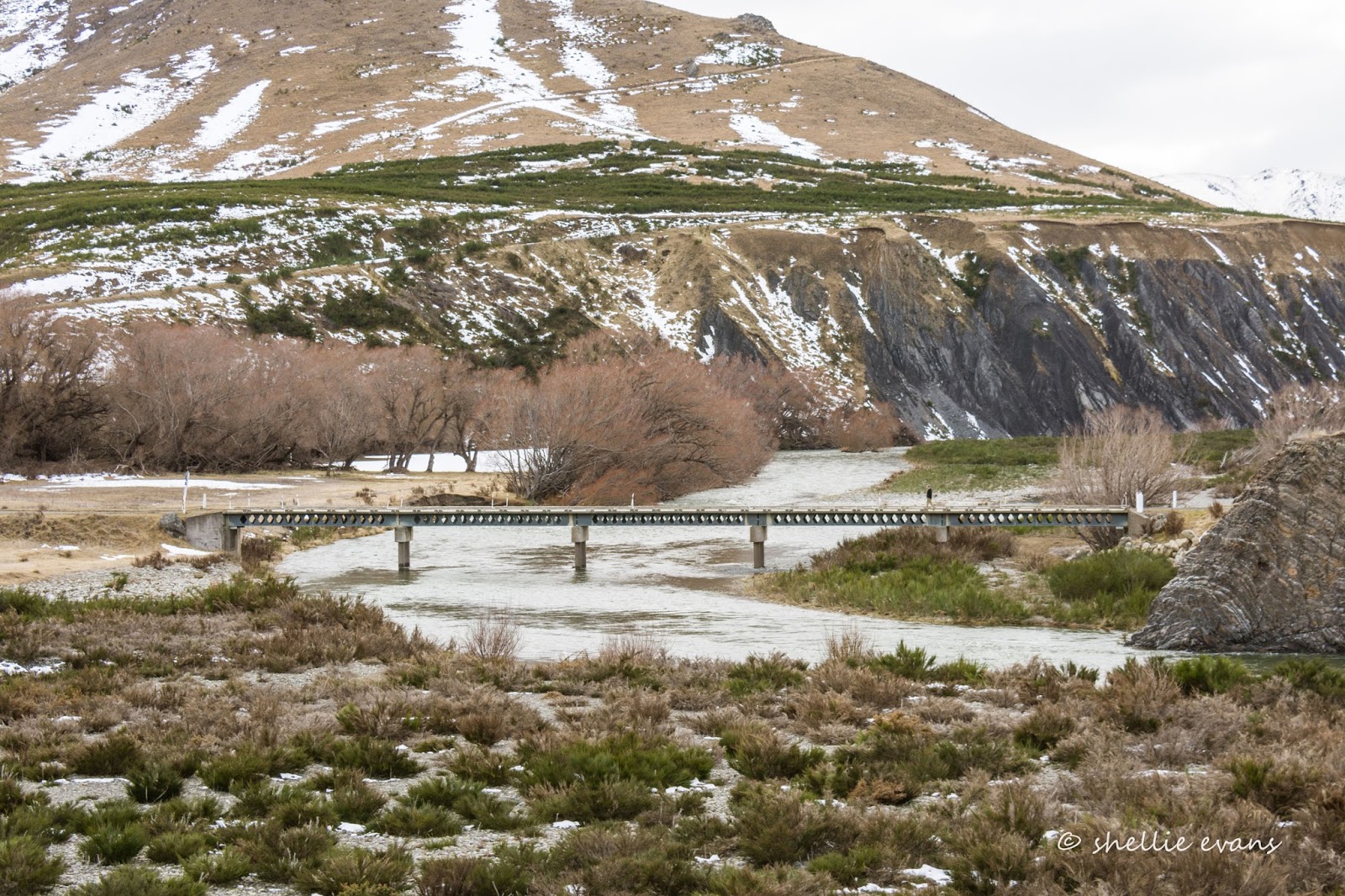

...and then carried on to pick him up at what happens to also be the boundary between Canterbury and Marlborough. Unfortunately, this is as far as we'll go today, there's locked chain across the bridge and I suspect there's a locked gate further on. We haven't driven the Molesworth road yet (it's closed over winter) but we've planned twice before and both times we had to abandon the trip; the first time the road was closed due to high fire risk and the second time the Kaikoura earthquake foiled our attempt. Maybe we'll get it done this summer when it reopens at the end of October.


We left the kayaker's car at the bridge and headed back along the road craning our necks to see if we could spot them everytime the river came into view. 


It was a fluke that we saw them when we did, from an area high above the river where we could watch them approaching...


...and then paddle through the riffles and off round the bend at the far end. David called to them as they went past to let them know the car was waiting for them at the bridge. Job done.


We carried on, heading straight into the bad weather we'd seen earlier rolling over the mountains behind us.


These two photos were taken just 1 hour apart- the one below I took as I followed David up the road.


We toyed with the idea of taking Jollies Pass Road back to Hanmer instead of Jacks Pass which was a little further on, we've crossed it before and it is a lot more rugged and you do need 4WD but it's doable. In the end the decision was made for us; it had a locked bar across the road just around the first bend. 


So it was back over Jacks Pass to Hanmer and what a difference two hours made to that journey! These two photos were taken at the top of the pass which actually sounds worse than it is. Jacks Pass isn't actually that bad, it's just a short climb up and then through the mountains that form a backdrop to Hanmer. 

But look at how quickly New Zealand mountain weather closes in on you; this is what catches tourists (and a few New Zealanders) out.


It was thick cloud and heavy rain all the way down the other side into the village. It was time to head home and crank up the deisel heaters.


Tuesday, July 15

Plenty of Pylons – Lake Tennyson

After we left Banks Peninsula we spent another couple of days back at the NZMCA Park in Weedons, Christchurch before once again hitting the road heading north. If we keep this up we’re not going to make Nelson before spring!

Our next stop was Hanmer Springs, the alpine resort village in North Canterbury. David had a special birthday to celebrate & I thought it would be nice to have a bit of time relaxing at the hot pools and David could also have a massage; he’s been missing his regular weekly massage that he used to have back in Tauranga. I forgot that it was school holidays! Chaos reigned. But I’ll come to that blog later.

To escape the masses we took a drive out to Lake Tennyson. Lake Tennyson is located 40km from Hanmer, on the well known Rainbow Road, a 112km wilderness 4WD road trip through sub-alpine country. The road starts behind Hanmer Springs and exits at the Nelson Lakes passing first through Molesworth Station, the huge (well in fact the largest) station in New Zealand & then Rainbow Station. This is not to be confused with the 207km Acheron Road which also traverses Molesworth Station and is the more well known journey. Both roads are closed over winter, the access gates locked from April to December although the Rainbow Road gate is much closer to St Arnard (Nelson Lakes) so you can travel it from Hanmer for about 76kms (as long as there is no snow)

Right behind Hanmer Village are two passes that take you over the Hanmer Range into the Clarence River Valley. Jacks Pass is the more popular route to take, Jollies Pass is only recommended for 4WD. We thought we’d take Jacks on the way over & Jollies on the way back. Jacks Pass was deeply corrugated, one of the worst gravel roads we’ve struck in our travels. David wonders how often they grade it, as going by the traffic we pass, it's a well used road. There are dozens of forest & mountain cycle & walking tracks on the range and we see plenty of cars with bikes of all sizes piled up on bike racks behind the cars or on trailers and roofs. The Hanmer Skifield is also over the range and up near the St James Conservation Area but as there has been hardly any snow this winter, it’s hasn’t opened yet.


Jacks Pass
Just before we pull over at the top of the Pass we come across a hiker with his Golden Retriever beside him, walking down the road. I recognise that it’s Mark Inglis, the well known mountaineer that lost both his legs after they became frost bitten while he was trapped in a snow cave on Mt Cook for 13 days back in 1982. He had his carbon fibre prosthetic legs on and looked to be managing the corrugations better than David did. I know he lives in Hanmer & is training for another overseas mountaineering expedition at the moment. He has a quest spot on Radio New Zealand quite often.


Heading down the Jacks Pass to the Clarence Valley
Once over the top we follow the Clarence River along Tophouse Road towards the old St James homestead & the start of the St James Cycle Trail. And we’re back into tussock grasslands, one of my favourite landscapes. The old rabbit proof fence borders  the road, there’s more about it further on.


We really are so lucky in New Zealand. There are so many wonderful walking, tramping & cycling tracks around NZ & especially out in the remote back country. It’s just a shame that there aren’t more people who can access some of these awesome trails. The 65km two day St James Cycle Trail (more of a mountainbike run looking at some of the route) is located in the St James Conservation Area, along with a number of other trails, there are also natural hot springs located near the trail at a couple of points which would be great for those over worked muscles.

St James Conservation Area covers 78,000 ha of native beech forest, tussock plains, rivers, lakes & mountains. It was once one of the largest operating cattle/sheep stations in the country & was purchased by the government in 2008 to protect it & open it up to recreation & tourism.


The cycle trail starts and finishes at Maling Pass or St James Station Homestead. We stop at the entrance to the old St James Station to have a look at the abandoned buildings left behind, including the woolshed, stables, cook house and the remains of the old homestead.


Going by the amount of old dog kennels scattered around underneath the gnarly old macrocapa shelterbelt they had a lot of farm dogs on this station.


And the farm dogs obviously had as hard a life as the settlers on this remote and rugged station.


We carry on up the road heading towards snow capped mountains with the weather looking like its about to close in on us. Other than two cars (without people) in the St James carpark we pass no one else until we return to Hanmer.

Two rows of pylons march down the river valley, here the wires catch the sun looking like a giant spider has passed through ahead of us.


Looking back to St James & the good weather.


A Pylon montage! I know that pylons are usually unsightly but beauty is in the eye of the beholder. These photos wouldn’t be as interesting without them.


The historic Fowlers Pass Track hut sits just off the road, a section of the cycle/tramping track runs up the valley from here.


Fowlers Pass (1296m) connects Fowlers Hut with Stanley Vale & Lake Guyon huts. The track has river crossings, scree slopes & in winter snow can make travel difficult. The area is also prone to avalanches. So not your average Sunday ride or walk.


The road we are on is reasonable, though there are a few repaired patches where the river, in flood, has come sweeping around a corner and washed it away. There’s also a high section that has been cut through a gravel slope, big rocks are scattered over it and we hope none decide to dislodge while we’re passing through.

Near the Maling Pass section of the St James Cycle Trail (the other start/finish point) we open the gate and enter Molesworth Station crossing the Clarence River for the first time.  This photo is actually taken on our way back out.


Not long afterwards we turn onto a track that will take us to Lake Tennyson. It’s a nice surprise to see that there’s a shelter with a table & bench that we can have lunch at. David (Stickman) first checks out the river to see if there are any trout, this is the Clarence River outlet from the lake.


Lake Tennyson is quite beautiful even though shrouded in rain and cloud,  it’s surrounded by tussock & alpine ground cover with a few stands of beech forest on the far shoreline. It’s a surprise to see a number of shags resting on a log on the lake edge just across the outlet & to hear ever-present & noisy Spur-winged Plovers kicking up a fuss at our arrival.


Inside the shelter there are a number of information boards.


Most of them tell about the struggle the area has had with rabbits. How the owner of Molesworth Station introduced wagonloads of cats he brought in from Christchurch, to try & control the rabbits. And that rabbits were the direct reason that Molesworth Station was returned to the crown in 1938. And all about 128km Waiau Rabbit Fence was “one of the most perfect rabbit fences in the world” (that’s the one I mentioned back at the top). I hope you can read some of the information, click on the photo to see a larger version.

Curried Rabbit anyone?


As we have our lunch the cloud lifts and the light rain stops, the lake becomes a millpond and we can now see the rugged slopes on the mountains behind. But it’s getting cold and it’s time to head home.


We weave our way back down the valley through the multitude of pylons and back into sunny weather.


We carry on past Jacks Pass and try our luck over Jollies Pass back to Hanmer. We had a bit of a laugh as we approached and saw where one row of pylons disappeared over the range. A very long time ago, we did a trip to the West Coast on the trans-alpine rail car, we hired a 4WD SUV and drove back to Christchurch via Lewis Pass, stopping at Hanmer for a few days.


We drove over Jacks Pass to look at the river and thought we’d return via Jollies Pass. Back then I don’t think the signage was a good as it is nowadays because just below this row of pylons there was a track which we thought must have been the pass, we’d been told it was 4WD only. We followed it up & up, I know it doesn’t look that steep from here, but believe me when you’re in the passenger seat looking straight down off the edge of a narrow mountain track with many washouts, it’s very scary.

The track got narrower, the rocks bigger & the ruts deeper. There was nowhere to turn around so we had to keep going. It was with some relief that the track finally ran out beneath a pylon right up on top & there was a small flat area full of rocks that we managed to turn around in and head back down. We decided Jacks Pass was all we could manage. It wasn’t until we were talking to a person at the information centre that we learnt we’d followed a pylon service track, a track that was only suitable for quad bikes. What greenhorns!

Today we drove on past the now overgrown pylon track and found the Jollies Pass track further on, we’d been told it was icy & slippery but we found most of it was fine, with a few slippery sections on the Hanmer side. It was, in fact, a lot smoother to cross than the corrugated Jacks Pass.

The view over the Hanmer Basin with Hanmer Springs village centre right.


Crossing Jollies Pass with a patchwork of forestry operations going not too far from Hanmer.