Showing posts with label pylon. Show all posts

Tuesday, March 10

Rainbow Road- Part 3: The Return Journey

I know you’re thinking, what more is there to write about the Rainbow Road after Parts 1 & 2. But if you've been following my blog for awhile, and/or know me well, then you’ll know that I'll still have plenty to write about and alot more photos to share.

We leave Lake Tennyson behind us for the second time on our travels and head back along the valley towards that horribly corrugated climb up to Island Saddle again.


Not far along we see a motorbike approaching from the distance and as we get closer to each other a calf makes a break across the road in front of us; there’s a small herd of cows and calves resting under the pylon, this one has suddenly realised his mother has crossed over and disappeared out of sight. I can see why the road is shut at night; black cattle + black night= kapow!


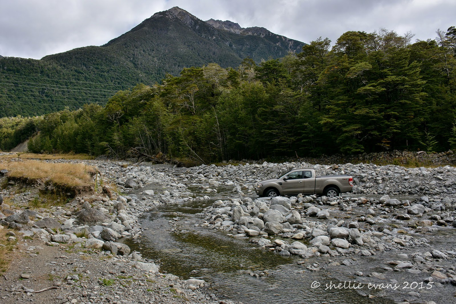
Towards the end of Island Gully, we take a short track that leads off the road to a DOC hut (4 bunks) overlooking the Wairau River. I’m thinking it’s a bloody long way to walk to collect water just as David points out a very narrow channel of water flowing through the tussock just below the sign. Honestly, if the sign wasn’t there you’d hardly know there was water close by.


It is here that I get my first bumble bee sting. Introduced borage grows profusely along the Rainbow Road, the blue flowers attracting many bees and whenever I step out of the car I’m suddenly surrounded by bumble bees. They don’t usually worry me and I prefer them to the persistent biting sandflies but today I’m wearing a bright blue top (duh!) and more than the usual number of bees are attracted to me. I raise my arms to take a photo and when I put them back down a bumble bee gets caught underneath one and gives me a zap. I don’t think they die like bees or wasps because he flew away once I quickly lifted my arm. He left behind an angry red welt that has been annoying me ever since!

This is my ‘bee’ photo- looking back towards the road we can see that massive ‘rock’ with its many scree slides that I mentioned in Part 2. On the left hand side, the slide has reached and crossed the road. I wonder how many times the road has to be graded to clear it.


Those ever present pylons line the road through this part. They are obviously popular with the cattle, as small groups rest underneath most of them- maybe they get a bit of energy from them….or perhaps they like the barrier the legs form; there are a number of huge Angus bulls wandering between the groups and I spotted one chasing a calf.


Just past Rag & Famish Creek (I’d love to know how that got its name) David gave a shout as he spotted what looked like a quail, running off the side of the road. I was looking in the wrong direction so didn’t see it but he also thought it was too big for a quail. Straight away I said I bet it was a Chukor. We pulled over and by the time I got out, the bird had reappeared and was running flat stick along the edge of the road away from us. And right behind her, running just as fast were 5 chicks. Our first sighting of a Chukor Partridge!

Chukor were introduced from Asia, as game birds in the 1920s and are only found in the South Island high country from Marlborough to Otago. They inhabit dry hill country, open scrub and tussock lands with scree slopes & rock outcrops east of the Southern Alps and up to 2,000 metres. We’re in the perfect country to spot them!


We attempt to  stalk them up the road but the mother flies across and up onto the slope behind. I was surprised to see the chicks fly after her albeit very low to the ground and landing quite a distance from her. She finds herself a rock to stand on and calls out to the chicks to hurry on up  ‘chuck-er…chuck-er…chuckar-chuckar’ , hence the name. I climb the slope a distance away from them and then move across above them in an attempt to find them hiding in the matagouri where we saw them disappear.

David is back on the road shouting directions (spot him? bottom left, bottom photo) but I think they've made a run for it and crossed into thicker scrub. We decide it’s time to move on and then, wouldn’t you know it, as I make my way back down the steep slope, gingerly picking my way around the needle sharp matagouri & rosehips, I flush the birds from under a bush I had stopped beside to check the route down. Of course I don’t have my camera ready and they fly off deeper into the scrub. Oh well, at least I got a few shots when we first arrived. Another bird to tick off our list.


We reach the boundary gate between the two stations; Molesworth & Rainbow and I spot a sign on a stake nearby. ‘Kikiwa 64km’. I googled to find out a bit more about it and while there isn’t much information it looks like it’s an area near St Arnaud and may have something to do with the transmission lines.


Now back on the private part of the Rainbow Road, there’s a noticeable difference between the two sections; the amount of gravel on the road (less), the narrowness of the road and the plants growing over the edge and along the middle of the road- more like a farm track which makes it an even better driving experience.


We approach the gravel slide with the washout again and have no trouble passing over it. Perhaps the station should use some of this gravel on their road.


We pass back through ‘Hells Gate’ the narrow gorge, failing to see where the fishermen have gone to, but spotting the tents of the cyclists who have set up camp for the night. Out the other side and the alpine scenery suddenly gives way to shaded beech forest reaching down the mountain sides. As we round a corner I spot a sign in the muddy bog off to the side. It would seem others have not been so fortunate in getting around the corner in one piece.


Finally we see the old Rainbow Homestead ahead of us, I open the gate and the lady who collected our toll this morning comes out to greet us. I chat to her for a minute or so; she tells me her family have worked on Rainbow Station for three generations, she loves the valley and enjoys being out here with her dogs & horses during the few months the road is open. Her husband comes out regularly and they live in Murchison over winter. She says she never gets lonely as there are plenty of people passing through each day.


She also tells us to make sure we stop at the swing-bridge further down the valley, it’s really beautiful. The sun has disappeared behind the mountains and it’s getting a little chilly but we stop for one last time to check it out. The swing-bridge crosses the Wairau and is the beginning of the Lees Creek tramping route which passes through a narrow valley and up to open flats higher up the Raglan Range, where there’s also a DOC hut.


There’s a steep stairway up the rock face at the end of the bridge and when I look back to take a photo I see David at the other end bent over swatting at sandflies. I wait for him to stand up but he disappears back up to the road, the sandflies getting the better of him. I cross back over the bridge and see that the rain is coming. The forecast for the next few days is heavy rain, we definitely chose the best day to do our road trip.


Back on the seal and guess what we come across at least half a dozen times? 1001 sheep making their way, at a steady pace, back to the front paddock.


We arrived back at camp around 6pm, the return journey taking us two and a half hours. We travelled 146km there and back- St Arnaud to Lake Tennyson and passed through three districts; Tasman, Marlborough & Canterbury.  The total length of the Rainbow Road from St Arnaud to Hanmer Springs is 112km but as we’d already driven the other end we only went as far as the lake.

And although it was quite tiring (for both driver & passenger) we thoroughly enjoyed exploring the iconic Rainbow Road with it’s magnificent scenery and incredible mountain ranges. The road itself wasn't too bad but I can imagine it cutting up rough at the slightest hint of bad weather. It’s definitely 4WD territory in a number of places but nothing too major.


Sunday, March 8

The Long & Dusty Rainbow Road- Part 1

While we're at Lake Rotoiti it was an ideal opportunity to drive the Rainbow Road, a 112km partly private gravel road that connects St Arnaud to Hanmer Springs. Originally we were going to drive the loop- the Rainbow Road & the Molesworth Road together, staying in Hanmer overnight. But the Molesworth has been closed for the season due to the extreme fire risk in Marlborough. The Rainbow Road was still open and as it’s only open from late December until Easter each year it made sense to drive it now.

We had already driven a section of the Rainbow Road; from Hanmer to Lake Tennyson, when we were in Hanmer Springs last July. This time we would drive the 73km to Lake Tennyson from the St Arnaud end, have lunch and then return via the same route, making it a very long 146km road trip.

We had also driven to the Rainbow Skifield turnoff when we were here at the Lakes last November so we knew that the first 26km of the road was sealed.

Along the way we came across the Rainbow Station farm manager shifting a large flock of sheep, we stopped to talk to him and he told us he shifts them everyday. He pushes them high up the valley in the morning and by the next morning they are back down at the homestead having found their way around the ends of a couple of fences (over the river & up in the bush) that should be blocking their path. He tells us that the feed is much better down at the homestead but he wants them up the top to clear it out before winter. Why he doesn't just add to the fence ends I have no idea. It will be interesting to see where the sheep are when we return later in the afternoon.


There are around a dozen ford crossings along the sealed section of the road, there are some interesting names and we stop to take a photo at the best one. Most of the crossings are dry at this time of the year with just a bit of rubble over the concrete pad.


It’s about here that I need to mention that the Rainbow Road is a hydro road and has only come about because of the route that the pylons take carrying power from Canterbury through to the Nelson & Buller regions, and as such, there are plenty of pylons in the photos. There’s very little chance of taking a photo without at least one making an appearance so I figured it’s best to embrace the pylons rather than try to shoot around them.

It might now be a hydro road (built in the 1950s) but a very long time ago it was part of the overland routes used by Maori and later used by high country graziers moving mobs of sheep between the regions.

This is as far as we traveled the last time, the first rocky ford crossing without a concrete pad and with a lot of boulders. The stream was quite a lot higher then and there wasn’t a nicely smoothed out loop to drive around just a deep crossing straight over. That was still there but we took the easier option, why go looking for trouble?


The gates that are locked in the off season are just past the ford but it’s another 10kms to the old Rainbow Station homestead where you pay a toll to drive the road. The road is good, although there are a few rocky patches, as it follows the Wairau River upstream. Along the way we pass a portaloo all on it’s lonesome & very strategically placed, we decide after a quick stop (and two cups of tea before we left).

Then we come across a working party up one of the pylons, they are blasting off rust and/or algae growth. They have their work cut out for them going by the number and precarious positions of the pylons we see further on. It would take them years to finish the job and I then I'm sure they would have to start at the beginning again. I’m now wondering if the portaloo might have been for them although it was a few kilometres away.


Finally the old homestead appears- a kilometre on a gravel road always seems to be twice as long. Dogs bark a warning and a lovely lady appears to take our money at the ‘toll booth’ which doubles as a wood shed, the wood pile acting as a high point for a boisterous puppy trying to see what his mistress is up to. We pay our $25 and the lady opens the gate for us. We tell her we’ll be returning later in the afternoon and she warns us it must be by 6pm when the gate is locked overnight.


We’re still driving along the river flats but the mountains loom off to the side and ahead of us.


We stop to open the first of the half dozen or so closed gates along the road and find another set of wagon wheels, there’s a similar set at the beginning of the road near the new homestead.


The Rainbow Road is advertised as a ‘wilderness driving experience’ only suitable for high-clearance 4WD vehicles. Drivers need to be self-sufficient and prepared for sudden changes in weather. So far it’s been a relatively easy road (except for the rocky ford). I think the real Rainbow experience is about to begin.


We see our first car approaching from the other direction, David pulls over to the side to let him pass once he’s crossed a ford. We see another 4 or 5 cars during the day along with a motorbike & four cyclists (who had stayed at Kerr Bay with us the night before) and who had set up camp at the Coldwater Creek camping area- a little less than the half way mark.


A colourful barn comes into view as we approach Hells Gate, a very narrow gorge that the road hugs through a gap in the mountains.


We cross the Wairau River close to where the Rainbow River joins it, the river after which the road and station are named.


We come across a parked vehicle just before the gorge, a guy is checking & measuring the water level. They must be power employees as we let them pass later on and they take a track up to a pylon above us.


The river has narrowed down a lot as it comes out of the gorge although it’s still very shallow.


We enter ‘Hells Gate’ and take our time driving through, stopping at one point to take in the impressive rocky mountain bluffs overhead. The road again isn’t too bad, just narrow in a few places with a couple of blind corners.


Towards the end of the gorge we come across a couple of cheerful chaps having their lunch on the side of the road. They’ve been out here for the last 3-4 days fishing, they have a Landrover camper with them although they told us they’ve been whiling away their evenings drinking with the DOC guys at a hut further up the valley!


The scenery is spectacular, the mountains surround us on all sides and those pylons take centre stage in the narrow gorge.


At the end of the gorge the road turns right and the landscape opens up as we continue to follow the river up stream.


There are a couple of huge rock slides off the mountains above us and one of them has wiped the road out. A track looks to have been bulldozed through lower down but water has washed that away. We take a narrow, higher up track which also crosses the water course but is not as deep (I took this on the way back in case it throws your bearings).


The road crosses over the next scree slide and then over another bridge across the Waiau…


…and along the side and to the top of the valley. You can see a couple of roads, the higher one is a service track to those ever present pylons. And even though it may not look like it from here, this is one huge impressive valley, the cattle grazing down below looking like ants.


At the top of the valley we come to another closed gate and the Rainbow/Molesworth Station boundary. The road now becomes a public road & it’s here that the gate is locked in the off season.


To be continued……

Part 2- Lake Sedgemere, Island Saddle to Lake Tennyson
Part 3- The Return Journey

Tuesday, July 15

Plenty of Pylons – Lake Tennyson

After we left Banks Peninsula we spent another couple of days back at the NZMCA Park in Weedons, Christchurch before once again hitting the road heading north. If we keep this up we’re not going to make Nelson before spring!

Our next stop was Hanmer Springs, the alpine resort village in North Canterbury. David had a special birthday to celebrate & I thought it would be nice to have a bit of time relaxing at the hot pools and David could also have a massage; he’s been missing his regular weekly massage that he used to have back in Tauranga. I forgot that it was school holidays! Chaos reigned. But I’ll come to that blog later.

To escape the masses we took a drive out to Lake Tennyson. Lake Tennyson is located 40km from Hanmer, on the well known Rainbow Road, a 112km wilderness 4WD road trip through sub-alpine country. The road starts behind Hanmer Springs and exits at the Nelson Lakes passing first through Molesworth Station, the huge (well in fact the largest) station in New Zealand & then Rainbow Station. This is not to be confused with the 207km Acheron Road which also traverses Molesworth Station and is the more well known journey. Both roads are closed over winter, the access gates locked from April to December although the Rainbow Road gate is much closer to St Arnard (Nelson Lakes) so you can travel it from Hanmer for about 76kms (as long as there is no snow)

Right behind Hanmer Village are two passes that take you over the Hanmer Range into the Clarence River Valley. Jacks Pass is the more popular route to take, Jollies Pass is only recommended for 4WD. We thought we’d take Jacks on the way over & Jollies on the way back. Jacks Pass was deeply corrugated, one of the worst gravel roads we’ve struck in our travels. David wonders how often they grade it, as going by the traffic we pass, it's a well used road. There are dozens of forest & mountain cycle & walking tracks on the range and we see plenty of cars with bikes of all sizes piled up on bike racks behind the cars or on trailers and roofs. The Hanmer Skifield is also over the range and up near the St James Conservation Area but as there has been hardly any snow this winter, it’s hasn’t opened yet.


Jacks Pass
Just before we pull over at the top of the Pass we come across a hiker with his Golden Retriever beside him, walking down the road. I recognise that it’s Mark Inglis, the well known mountaineer that lost both his legs after they became frost bitten while he was trapped in a snow cave on Mt Cook for 13 days back in 1982. He had his carbon fibre prosthetic legs on and looked to be managing the corrugations better than David did. I know he lives in Hanmer & is training for another overseas mountaineering expedition at the moment. He has a quest spot on Radio New Zealand quite often.


Heading down the Jacks Pass to the Clarence Valley
Once over the top we follow the Clarence River along Tophouse Road towards the old St James homestead & the start of the St James Cycle Trail. And we’re back into tussock grasslands, one of my favourite landscapes. The old rabbit proof fence borders  the road, there’s more about it further on.


We really are so lucky in New Zealand. There are so many wonderful walking, tramping & cycling tracks around NZ & especially out in the remote back country. It’s just a shame that there aren’t more people who can access some of these awesome trails. The 65km two day St James Cycle Trail (more of a mountainbike run looking at some of the route) is located in the St James Conservation Area, along with a number of other trails, there are also natural hot springs located near the trail at a couple of points which would be great for those over worked muscles.

St James Conservation Area covers 78,000 ha of native beech forest, tussock plains, rivers, lakes & mountains. It was once one of the largest operating cattle/sheep stations in the country & was purchased by the government in 2008 to protect it & open it up to recreation & tourism.


The cycle trail starts and finishes at Maling Pass or St James Station Homestead. We stop at the entrance to the old St James Station to have a look at the abandoned buildings left behind, including the woolshed, stables, cook house and the remains of the old homestead.


Going by the amount of old dog kennels scattered around underneath the gnarly old macrocapa shelterbelt they had a lot of farm dogs on this station.


And the farm dogs obviously had as hard a life as the settlers on this remote and rugged station.


We carry on up the road heading towards snow capped mountains with the weather looking like its about to close in on us. Other than two cars (without people) in the St James carpark we pass no one else until we return to Hanmer.

Two rows of pylons march down the river valley, here the wires catch the sun looking like a giant spider has passed through ahead of us.


Looking back to St James & the good weather.


A Pylon montage! I know that pylons are usually unsightly but beauty is in the eye of the beholder. These photos wouldn’t be as interesting without them.


The historic Fowlers Pass Track hut sits just off the road, a section of the cycle/tramping track runs up the valley from here.


Fowlers Pass (1296m) connects Fowlers Hut with Stanley Vale & Lake Guyon huts. The track has river crossings, scree slopes & in winter snow can make travel difficult. The area is also prone to avalanches. So not your average Sunday ride or walk.


The road we are on is reasonable, though there are a few repaired patches where the river, in flood, has come sweeping around a corner and washed it away. There’s also a high section that has been cut through a gravel slope, big rocks are scattered over it and we hope none decide to dislodge while we’re passing through.

Near the Maling Pass section of the St James Cycle Trail (the other start/finish point) we open the gate and enter Molesworth Station crossing the Clarence River for the first time.  This photo is actually taken on our way back out.


Not long afterwards we turn onto a track that will take us to Lake Tennyson. It’s a nice surprise to see that there’s a shelter with a table & bench that we can have lunch at. David (Stickman) first checks out the river to see if there are any trout, this is the Clarence River outlet from the lake.


Lake Tennyson is quite beautiful even though shrouded in rain and cloud,  it’s surrounded by tussock & alpine ground cover with a few stands of beech forest on the far shoreline. It’s a surprise to see a number of shags resting on a log on the lake edge just across the outlet & to hear ever-present & noisy Spur-winged Plovers kicking up a fuss at our arrival.


Inside the shelter there are a number of information boards.


Most of them tell about the struggle the area has had with rabbits. How the owner of Molesworth Station introduced wagonloads of cats he brought in from Christchurch, to try & control the rabbits. And that rabbits were the direct reason that Molesworth Station was returned to the crown in 1938. And all about 128km Waiau Rabbit Fence was “one of the most perfect rabbit fences in the world” (that’s the one I mentioned back at the top). I hope you can read some of the information, click on the photo to see a larger version.

Curried Rabbit anyone?


As we have our lunch the cloud lifts and the light rain stops, the lake becomes a millpond and we can now see the rugged slopes on the mountains behind. But it’s getting cold and it’s time to head home.


We weave our way back down the valley through the multitude of pylons and back into sunny weather.


We carry on past Jacks Pass and try our luck over Jollies Pass back to Hanmer. We had a bit of a laugh as we approached and saw where one row of pylons disappeared over the range. A very long time ago, we did a trip to the West Coast on the trans-alpine rail car, we hired a 4WD SUV and drove back to Christchurch via Lewis Pass, stopping at Hanmer for a few days.


We drove over Jacks Pass to look at the river and thought we’d return via Jollies Pass. Back then I don’t think the signage was a good as it is nowadays because just below this row of pylons there was a track which we thought must have been the pass, we’d been told it was 4WD only. We followed it up & up, I know it doesn’t look that steep from here, but believe me when you’re in the passenger seat looking straight down off the edge of a narrow mountain track with many washouts, it’s very scary.

The track got narrower, the rocks bigger & the ruts deeper. There was nowhere to turn around so we had to keep going. It was with some relief that the track finally ran out beneath a pylon right up on top & there was a small flat area full of rocks that we managed to turn around in and head back down. We decided Jacks Pass was all we could manage. It wasn’t until we were talking to a person at the information centre that we learnt we’d followed a pylon service track, a track that was only suitable for quad bikes. What greenhorns!

Today we drove on past the now overgrown pylon track and found the Jollies Pass track further on, we’d been told it was icy & slippery but we found most of it was fine, with a few slippery sections on the Hanmer side. It was, in fact, a lot smoother to cross than the corrugated Jacks Pass.

The view over the Hanmer Basin with Hanmer Springs village centre right.


Crossing Jollies Pass with a patchwork of forestry operations going not too far from Hanmer.