Showing posts with label jenny pattrick. Show all posts

Saturday, March 28

Denniston Incline - Part 2

Continuing on from Part 1

We followed the track away from the Incline area passing through regenerating bush on our self-guided walking tour. It’s along this steep bank that the Camp took shape. There was no order; shacks & huts, some still half canvas, sprouted wherever their owners decided. There were no roads either, just a track down to the Camp then winding paths between dwellings. A few sturdier chimneys still stand….


….elsewhere iron and rubble from buildings has been pushed over the side, left to weather and eventually rot away or be overtaken by the slowly encroaching bush. I spoke to a old-timer who was manning the information kiosk where ‘The Denniston Experience’ tours depart from. He told me that all the management houses and camp buildings were demolished when the Incline was closed because they were worried that squatters (or his words, ‘a commune of hippies’) would set up camp in the empty buildings.


The track eventually led to the Banbury Arches; a dry stone wall bridge and tramway that carried coal from the Banbury Mine (1879-1890) to the Incline. This mine was one of the first mines to open on the plateau but after a few years it was used as an access tunnel to the bigger mines behind it, bringing their coal through the mine and on to the Incline.


The Banbury Mine entrance (the dark patch) can be seen just to the left and above the smaller arch. In the early days horses were used to haul the tubs of coal to the Incline, nowadays the Denniston Experience tour uses the mine & tramway for their small rail carriages, taking people into the mine on a ‘real miner’ experience. Originally the mine was only 1 metre high, it has now been increased to 2 metres. Which is just as well, as I’m sure there would have been many suffering from claustrophobia.


We wander back along the track and end up on the Rope Road. A surface rope road was built in 1904 to haul the coal from the distant mines, it replaced a steam driven overhead chain which in turn had replaced the horses (remember to click on the photos if you’d like to read the information boards)


If you are a fan of the ‘Denniston Rose’, the fictional novel written by Jenny Pattrick, or her sequel ‘Heart of Coal’, about life on Denniston Plateau, you can follow the Denniston Rose trail which contains 17 numbered stops for key events in the books. Look out for the rose & coal symbols along the way. You can download a free “Denniston Rose’ app (iphone only) that will talk you through the tour or collect a Denniston Rose Trail booklet ($2 from the information Kiosk at the entrance- not always open)


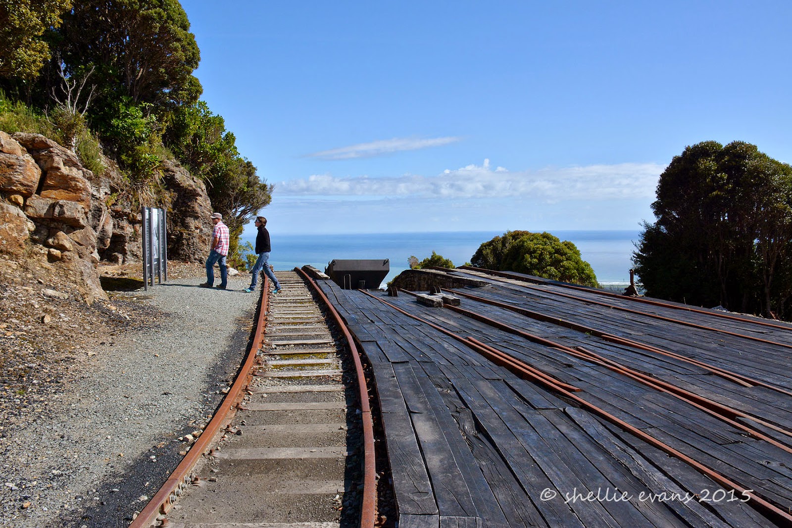
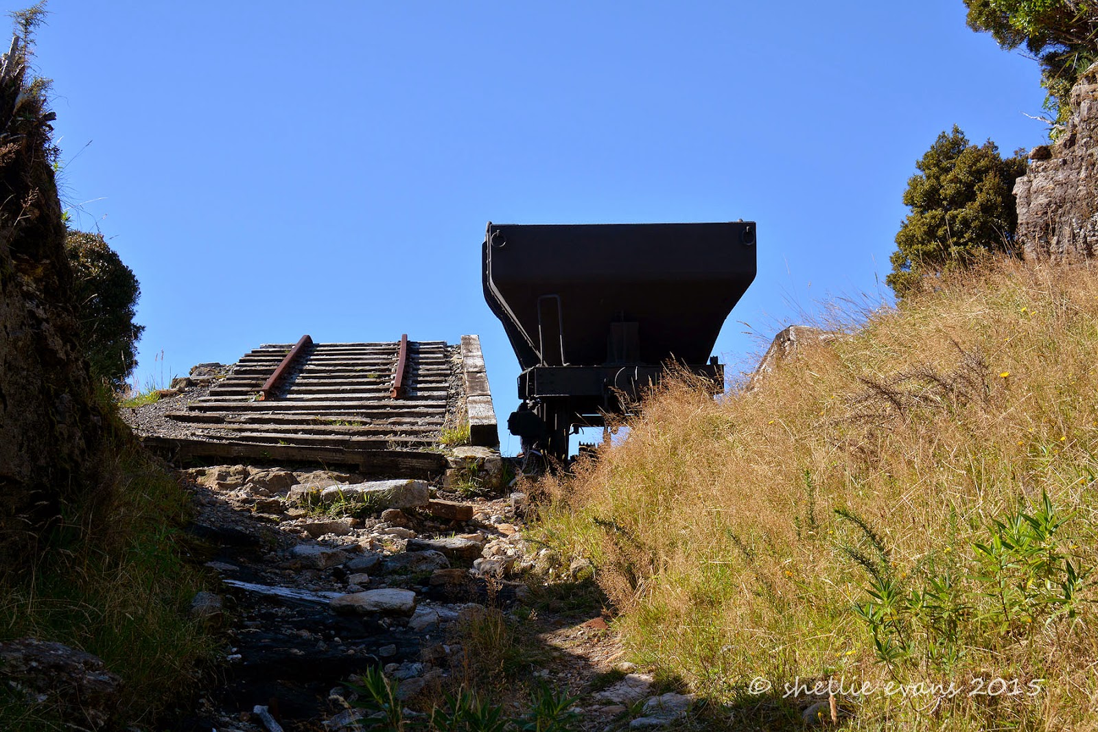
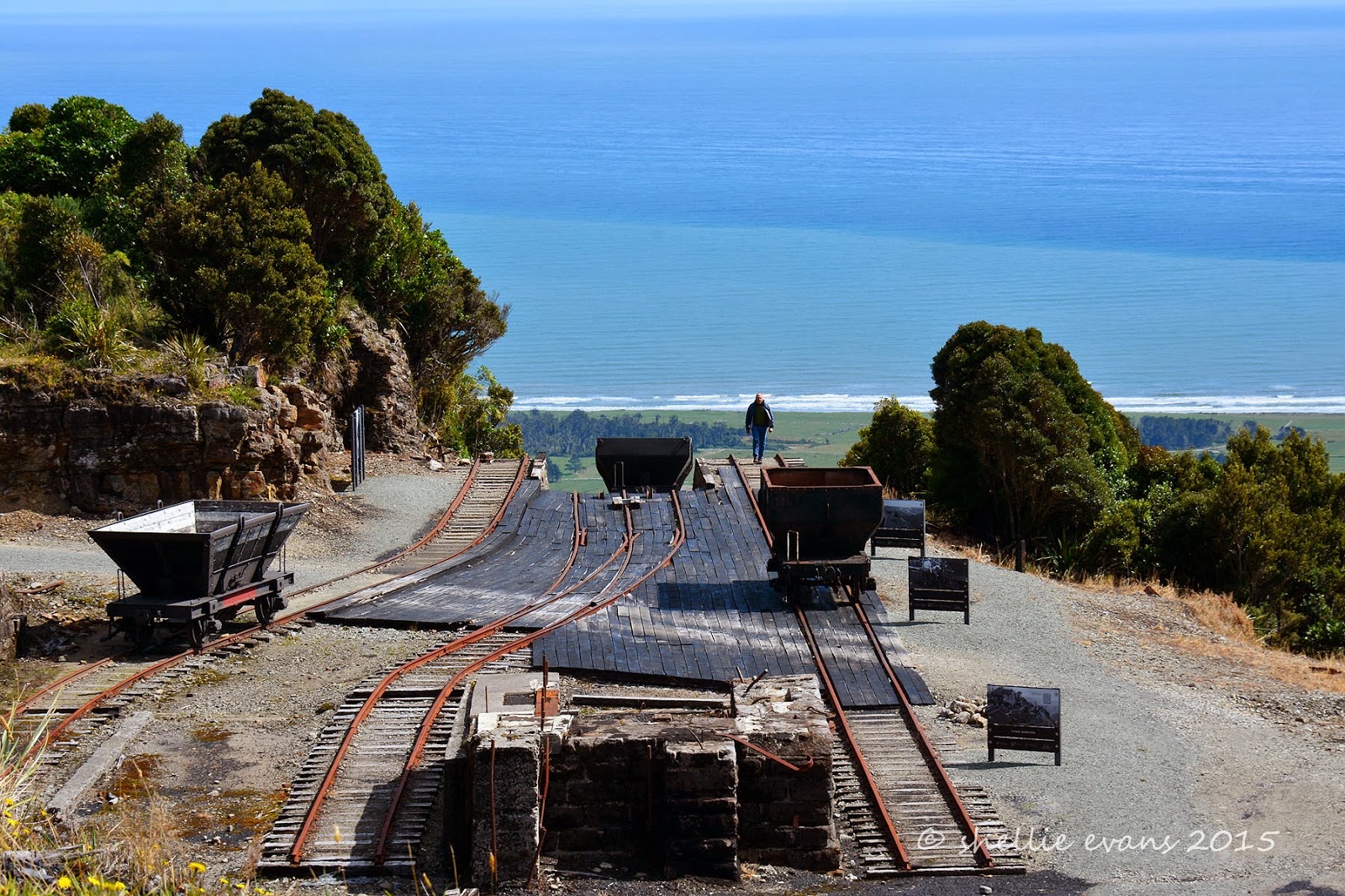
The chimney in the photo below belonged to the smoko shed and it was here the men (& boys) working nearby used to warm their hands on cold winter mornings. We’re approaching the level above the Incline where the rope road haulage engine was located. The engine pulled the rope that hauled the coal tubs from the distant mines of Burnetts Face.


Boys as young as 14 started their working lives here at the clipping shed, clipping and unclipping the tubs of coal to and from the endless rope.


We come to the end of our walking tour and find a table near the motorhome parking area, overlooking the Incline and that fabulous view, to have lunch. We’re joined by a small party on a cycling tour of New Zealand. That's my idea of a cycling tour; they cycle small sections of the journey- the interesting bits- then the bikes and passengers are carted up and/or through any difficult parts. This group were about to ride the Denniston Plateau road- down, all the way!


After lunch we drove further on into the plateau to the old Burnetts Face, passing old historic mining sites along the way. There were a number of townships along this road; Denniston, Burnetts Face, Coalbrookdale & Marshvale (also known as Pommy Town). Burnetts Face School was located near the DOC sign in the photo, bottom left. Now it's just barren rock and scrub.


Then it was back down the winding road with the perfect view out over Westport with Cape Fourwind behind. I can even pick out the NZMCA Park on the beach- the white speck in that second curve of the first bay.


Once at the bottom we make our way to Conn’s Creek to look at the Incline from the bottom of the bluff….


…along with more mining relics. Located around the plateau and down the road are a number of signs from the ‘Friends of the Hill’ museum, showing where houses were built and information about some of the people that settled on the plateau.


Here’s an extract from the Denniston Rose, about Mary's first encounter with the Incline-
‘A grey mist lies over the bush. The wagons appear out of it, ascending and descending eerily. Mary climbs aboard willingly enough….But as the wretched jerking thing rises she loses her balance and tumbles backwards, with the twins, several bundles and the bed-head on top of her. For a moment she fears she she will fall out and screams aloud as the jagged ends of cut branches tear past, a nose-breadth away’
I climbed up the first short section to where the creek crosses underneath and where part of the Incline had been washed away.


Our final stop was out near the mouth of the Waimangaroa River, at the Waimangaroa Cemetery. The cutting of the Incline shows clearly from a distance. I hope they always keep the line clear, it would be a shame to loose the impact of the cutting to the regenerating bush.


The rock on the plateau was too hard for digging graves, many of the people that lived and died on the plateau are buried here. In the early days the coffins with their precious cargo were sent down the Incline, the only way to get them to the bottom.

In the shadow of the Incline.


Often the loved ones could not be at the burial or visit afterwards. After their initial ride up the Incline, they had a fear of riding it again. Many never left the Plateau alive again.


The final resting place for many of Dennistons’ brave & hardy residents, overlooking the West Coast’s wild Tasman Sea, although on this day it’s calm and serene.


The Department of Conservation, with the help of many volunteers & workers has done an amazing job in restoring and bringing alive the Denniston Plateau, and in particular the Denniston Incline, what a wonderful tribute to the men & women who eked out a living and survived the harshest mine site in the country.


Friday, March 27

‘Damn Denniston’ - Part 1

Ever since Mum & Dad gave me the book ‘The Denniston Rose’ by Jenny Pattrick for my birthday back in 2003, I have been waiting for the chance to visit the historic coal mining site on the West Coast.

The novel, based in the 1880s, is about a young girl, Rose, & her mother who lived in appalling conditions, along with mine workers, in their makeshift collection of huts, tents & saloons in the bleak & isolated coal-mining settlement of Denniston. Denniston is located high up on a plateau where the only access was by a steep bridle path or by riding the coal wagons up and down the terrifyingly steep Denniston Incline. The people in the novel are fiction but the events and conditions are historical facts.

Between 1879 and 1967 the greater Mt Rochford Plateau mines were New Zealand’s largest producing coal mines, producing an estimated 12,600,000 tons of premium quality coal. Once the coal reached the Denniston Plateau it was loaded into railway wagons and lowered by cable down the steep incline railway, the famous “Denniston Incline” (referred to as the eighth wonder of the world by locals) and a remarkable feat of engineering & industrial innovation.

There is now a 9km steep, winding and narrow road to the top of the plateau, a road that is shared by many coal trucks coming and going from the Bathurst Opencast Mine which is located further back on the plateau. The trucks have radio contact with each other and wait patiently for any larger vehicles making the ascent.


I hoped for a fine day. In fact we probably wouldn't have visited if it was anything but a fine day- the view seaward is spectacular and part of the experience. The weather up on the plateau is notoriously bad and it’s often shrouded in mist, fog and cloud, or all three. Then there’s the snow, wind and rain. Luckily we had a gloriously fine day.


While the historic Incline has always been a point of interest, in recent years the Incline area has been upgraded & restored. A path leads visitors past old machinery, mining relics, rail lines, the brake head, hopper wagons and building remains with many informative interpretation panels along the way. The building above was once the workshop, it now houses comprehensive information panels about the lives and times of the people living on the barren & windswept Denniston Plateau. It’s where the start of the self-guided walking tour departs from.


After giving the old mining gear on the top level a cursory glance, I was keen to get down to the Incline level.

And there is was, the view I was waiting to see. Spectacular. The plateau overlooks the coastal plains of the Karamea Bight and the mouth of the Waimangaroa River.


The path led around the brakehead & bin shed area to the Brakehead Shelter(red roof) and to the top of the Bridle Path behind (which has been closed due to major slips). There were more information panels…


…and this interesting ‘look into the past’


And there, finally, was the poem I had been waiting to see. The poem that appears at the beginning of the ‘Denniston Rose’. The poem which had grabbed my attention & imagination and has remained with me. The poem that I copied into a journal and thought I’ll visit there one day. A poem that reflected how tough life was for our early miners & pioneering women.


We approach the top of the Incline.


Back in 1878 there were many challenges to be faced when coal was discovered on the plateau. One was how to get workers up the steep bluffs that soar 518 metres above the coast, the other was to get the coal safely down. The plan was to drop coal filled wagons straight over the side on rail tracks. The wagons were paused at Middle Brake, a  253 metre vertical drop to the mid-way point before they were dropped a further 263 metre vertical fall to the bottom, at Conn's Creek. The total distance traveled was 1.6kms. The weight of a full wagon dropping over the side brought up the empty wagons from below. These were frequently used as a 'lift' for workers & families and their household items. Although extremely dangerous to travel on, compared with the climb up the bridle track it was well worth it.

A Q-class hopper wagon ready to drop.


David doing his Marc Antony speech- ‘Friends, Romans, countrymen lend me your ears


Looking down the famous Incline, which doesn't actually look too steep from here. But believe me it is. The coal wagons came to a halt in the first white patch (now a carpark) in the valley below. The coal carried on along rails to main railway at Waimangaroa (the settlement at the bottom of the bluff) It was then carted to Westport and loaded into colliers for shipping overseas.


Rather than copy over all the statistics, I took a photo- click to enlarge


Looking back up to platform from where I took the incline photo above.


Back up on the Brakehead; the information panels have photos of how it looked before and showed a red spot where you would have been standing then. It was fascinating & also hard to imagine the buildings that filled the platform in front of us (click to enlarge) and to think that many of the buildings and houses remained here until the 1980s. Although they stopped using the Incline in the late 1960s- road transport had taken over.


There were a number of old coal wagons made of various materials and in different shapes that had been used over the years.


The Denniston Incline-

then…..


and now


I couldn’t get enough of the wagon about to drop over the incline. To think that many people rode the wagons to the bottom, and quite a few lost their lives doing it too.


To be continued…..Part 2