Showing posts with label mine. Show all posts

Tuesday, March 28

Macraes Giants- Otago; Part 2

Continued on from Part 1

After walking around the wetland we carried on through Macraes heading north, not too sure if we'd go much further as it was getting late. We'd given up on looking for lizards, we'd not found any suitable habitats since leaving the rocky tors back at the beginning of the road. We thought we'd take a drive down Golden Point Road, just out of town, to the old historic stamper battery reserve towards the end of the road.

But we got sidetracked. It was a huge surprise to come up over the hill just out of Macraes to find ourselves in the middle of a huge mine, with a massive dirty grey haul road passing under our road bridge...


...and a sign pointing the way to an observation and lookout point. Of course we had to take a look.


We parked beside one humongous spare tyre- our fifth-wheel? 


Unfortunately the wind was whipping through the site and the dust and grit being blown about was diabolical. David was not very happy that he and the rig were being sand-blasted every few seconds. 


Luckily the track lead to an Observation Hut with large glass windows overlooking the huge open cast mine pit (click to enlarge). Check out the size of the 'little' ute behind the truck on the right.


Oceana Gold's Macraes Mine is New Zealand's largest gold producing mine, producing over 4 million ounces of gold to date. The area leased by the mine covers around 27,500 hectares. There are two mines, Macraes Open Pit which has been operating since 1990 and Frasers Underground which began in 2008. Frasers is 740 metres below surface and 200 metres below sea level, with over 48 kilometres of tunnel drives.


The majority of of haul trucks used at the mine are CAT 789Cs, there are 18 in use and we watch as a steady stream of them climb up the road full, disappearing around the back of the administration buildings and returning sometime later empty. You can see a mine portal in the background of this shot.


Here are some facts for you- the tray can carry 191 tonnes of rock, that's about 91,680 shovel loads or 7,640 wheelbarrow loads of rock. 


It takes about two and half minutes or 4-5 scoops to fully load the tray. It would take a man 382 hours or nearly 10 working weeks to fully load a 789C tray with a shovel.


More facts- 
Overall Height- 6.2mtrs, Length- 12.2mtrs, Width- 7.7mtrs
Operating Weight- 317,520 kgs
Empty Weight- 126.48 tonnes
Gross Power- 1750rpm:18sec
Fuel Tank Capacity- 3,218 litres
Engine Horsepower- 1900hp
Maximum Speed on 12% gradient- 10kph
Each Tyre costs $35,000


Here's a closer view of the size comparison between a standard vehicle and a haul truck. Note the bendy fibreglass pole with orange flag attached to the smaller truck (a bit like the ones we had on our bikes when we were kids). We passed a few utes with them attached back near a mine at Piano Flat, they looked quite strange waving about high in the air, driving along on a normal road at 100kph. Of course they need them on the mine roads so the big boys don't run over the top of them!


In amongst the haul trucks was an equally huge water tanker driving continuously up and down the haul road damping down the dust (we needed him up the top) and making a very slick surface for the trucks to pass over. 


The water tanker has a massive 52,000 litre capacity, it stopped beside a small pond on the haul road and took about a minute to fill, and then it was off again.


Imagine the cleaning job on any vehicles that travel this road. Although if you were behind him in your little truck you'd get an instant car wash when he tuned on the jets!


We never saw another vehicle while on the Macraes Flat Road so I'm sure we must have been the mine workers only entertainment for the day, especially driving around with our home on the back (or perhaps it was because I was hanging out the window taking photos as we crossed back over the bridge). 


We got a few toots (or should I say honks) from the drivers as they passed underneath on their way to the processing plant which is quite a distance from the mine.


We headed off down Golden Point Road- farmland on one side and reclaimed mining land on the other, most of it a huge terraced hill. At one point a bulldozer was smoothing out the side of a new tailings hill, and on a very steep angle too.


Towards the end of the sealed road we came across the processing plant, this is what we could see from way across the valley on the way in.


And there, approaching the plant from behind were the haul truck, water tanker and 'little' truck that had passed under the bridge while I was taking photos. Their road was more direct.


I took a screenshot of the Google aerial map over the top of the mine, it's pretty impressive and frightening ugly at the same time. Although as David, who hates all the old historic mine tailings and what they've done to the landscape says, at least this will be left clean, tidy and environmentally friendly when they finish.....even if a couple of hills have been moved in the process and a giant bird has been left behind to pacify the locals!  (Click the map at the bottom of the blog if you'd like to see more detail)


We didn't make it to the historic battery, just after the processing plant the road turned to gravel and dropped down into a gorge, the wind was still blowing hard, it was hot, dry and dusty and we were getting weary, so we turned around and headed out. Back along the Macraes Flat Road, heading back towards Hyde, wondering where we might bed down for the night.


Well, it just happens that while I was taking photos of that old iron bridge on the way in, I spied...


...a couple of potential freedom camping sites off a gravel track alongside the river...


...which was how we found ourselves sandwiched between tinder dry overgrown grass with several beehives as neighbours for the night. I didn't have the heart to tell David we were parked on the track from the ford over the river. I figured they'd be no large farm machinery crossing over at this time of the day. Although the farm traffic that 'flew' along the track in front of us did a double take.


Sunday, March 26

Macraes Giants- Otago; Part 1

Real-time

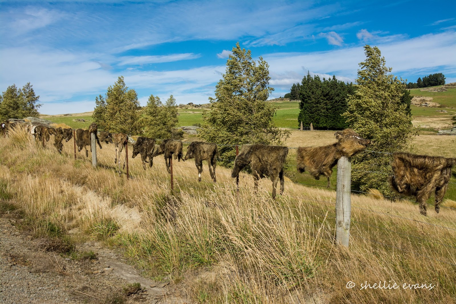
We went looking for giant lizards at Macraes Flat, instead we found a giant bird, a giant mine and a giant collection of pig skins!


We travelled through some new territory on the way to Macraes Flat, following the eastern end of the Otago Rail Trail which finishes (or starts, depending on which way you ride it) in Middlemarch. We stopped at the old Hyde Hotel where many bikers call in at the cafe for refreshments on their way through.


I also took the obligatory church photos (both now decommissioned) and one of the the old school, which is now a cyclists accommodation lodge.


A little further on we turn left and head up onto the rocky plateau ahead of us. We're on a bit of wild goose chase, one I don't hold out much hope in being successful in either. But we have all day ahead of us and nowhere we need to be in a hurry. And we have our home on the back, so we'll stop where and when the fancy takes us. 


We're looking for Grand Skinks and their slightly larger brothers the Otago Skink, they are New Zealand's largest lizard at 300mm (11 inches) long. They are very rare, very endangered and found only in three or four small areas in Otago, including in the Macraes Flat conservation area.


We've only ever seen them at Orokonui Ecosanctuary in Dunedin where they are successfully breeding- that's a young lizard riding on a parent's back with two juveniles on the rock below. The baby is about the size of the usual skinks people see in NZ.


I took these photos also at Orokonui- that's an adult top left and a baby bottom right and look how well camouflaged they are in the bush. You've probably guessed due to the lack of photos from elsewhere that we failed to find any skinks at Macraes Flat. Which actually isn't that surprising considering the fact that, in the end, we ran out of time and didn't even look! 


Here we are crossing the Taieri River for the upteenth time on our travels. This isn't surprising given that the river is 318km long and flows from the upper reaches of the Maniototo Valley, makes a dramatic U turn around the northern end of the Rock & Pillar Range and flows down through the Strath Taieri Valley (where we are) all the way to the ocean.


We've crossed back and forward over the Taieri River numerous times while exploring the Maniototo and Otago, we've been to the top in the Maniototo Valley and seen the Upper Taieri Scroll Plain where the river begins its journey (click to enlarge) and to the bottom, staying at Taieri Mouth not long after we started this journey and everywhere in between.


This beautiful old iron lattice truss bridge over the Taieri was built in 1879.


It was a long, slow and steady haul up onto the plateau where the views back over the valley to the Rock & Pillar Range behind were absolutely stunning. The Rock & Pillars rise to 1450m and are named for the impressive tors along the ridge. 


We pass many hundreds of tors on this side of the valley too, in fact we could still be in Central Otago as the landscape is so similar, and then travel on past farmland atop the Taieri Ridge. It took a few moments to register what we were seeing strung along the fenceline ahead of us as we passed here.  As far as the eye could see ahead... 


...and once we stopped, back behind us, at least a kilometre of animal skins! Collected over the past 20 years they are mostly wild pigs but deer, goat and wallaby skins are in there too, some complete with skulls. Eeuw!


There are many bizarre fences in New Zealand; Cadrona's famous bra fence, several shoe fences, a jandal (flip-flop) fence or two, bike fences, hubcap fences, number plate fences but now we've seen it all! No wussy collection here, this is a true Southern Man's fence! 


Further on, and as we drop down into the a huge basin of Macraes Flat, far across the valley we can see some terracing on the hills and steam rising from chimneys near what looks like a very large mine site (I've zoomed in here). I wonder if we'll get close...


Eventually we pull into the old gold mining settlement of Macraes (pop. 54). where there's neither sight nor sound of people about, even though it's a holiday Monday. In 2014 the settlement changed its name from Macraes Flat to Macraes so as to distinguish itself from the surrounding district.


We have lunch parked beside the old stables of the historic Stanley's Hotel (1882) which is across the road.


Stanley's Hotel was owned by Oceana Gold, the gold mining company that runs the nearby mine. In 2015 it was returned to the community in exchange for some impressive artwork....well one piece of impressive art, I'm not so sure about the others.


Located behind where we're parked is the Macrae Heritage & Arts Park and wetland, originally given to the community by the mine it has now been exchanged for the hotel, other heritage buildings, land and money. 


Eventually, I'm sure, the park will be given back to the community. I mean what's a gold mine going to do with a 9m high, 750kg big bird, a tussock planting and numerous large billboards (a very odd contribution if I must say so myself).


The bird on the other hand is a stunning sculpture and such a pity it's not seen by many people. You could drive straight through Macraes and not spot it, or even visit the settlement and not know of it tucked out the back.

With a 12m wingspan, it is of the long extinct Haast's Eagle, a bird that in reality weighed about 15kgs and had a wingspan of 3 metres. It was known to attack and eat moa, the sculpture is in attack mode here. As befitting a bird of this size the eagle was flown, beneath a helicopter, from sculptor Mark Hill's (son of jeweller Michael Hill) home in Arrowtown to Macraes in 2008. Now that would have been an impressive sight. 


This little dog's grave stone and plaque has been moved to near the entrance to the walkway around the wetland and sculpture park. What a sad little poem; David & I couldn't decide whether the driver ran back and forth over the dog until she died or just ran over her and killed her outright. Either way it was obviously a very traumatic time for her owner, and just before Christmas too.


I took a quick walk up the road to locate the local church, and as with many of NZ's abandoned or nearly abandoned country settlements, this is another church that has seen better days. This is the former St Patrick's Catholic Church, a Category 2 listed Historic Place building, now located in a horse paddock and in a sad state of disrepair.


To be continued... Part 2


Tuesday, November 29

Two West Coast Mining Towns

Catch-up

After our sobering and thoughtful visit to the Pike29 Memorial we carried on towards Greymouth, taking a side road to the old mining settlement of Blackball.


And although the streets around village's few shops and one of the pubs, were lined with vehicles, the streets were deserted of people. The only sign of occupancy were these two characters resting in the shade of an old cottage in the midst of a makeover. 


David dropped me off so I could take the necessary church photos and then drove around the block (the block nearly being the whole village) and pulled up outside the other pub in town and the one I wanted to check out- the 'famous in New Zealand', Blackball Hilton.....now known as the former Blackball Hilton because of a certain international hotel chain's pressure to change the name.


Next door I finally found a single person checking out the Blackball Museum of Working Class History including an exhibition of the 1908 miners strike, which at 10 weeks, is the longest strike in New Zealand. Blackball is also the birthplace of the New Zealand Labour Party.


The Blackball Hilton publican & his wife came out to front table to have a smoko break and we got talking. The town was empty of people but full of vehicles because of a very large funeral for a local identity which was happening at the other hotel in town. When he heard we'd just visited the memorial he said we'd have to come in and see the hotel's memorial to the Pike 29. The first thing he pointed out was the clock, it was fixed on the time of the blast.


He took great pains in pointing out that his wall was the first memorial to the Pike 29 and that the hotel was in fact where many of the families and rescuers stayed and met each day during the early attempts at rescue. There were also memorials and information on the other walls right through the hotel of other mine disasters and important events in the area's history. After thanking them for their hospitality, we continued our journey.


Our destination for the night, as previously mentioned was Jellyman Park near Greymouth. We'd set up camp and were relaxing in the warm late afternoon sun when I had a brainwave (David would say a brainfade)...it was a lovely evening and when I checked my tide app, I saw that sunset was at 8:09 and low tide was at 8:15pm. 

Perfect timing for another visit to the fabulous hidden coastline at Motukiekie, 15kms up the coast- low tide, rock formations, a West Coast sunset & hopefully the special orange starfish, that inhabit the rock pools at very low tide and which I'd failed to find on our previous visit (although we did manage to find a caveman). All that combined (not the caveman though) could make for an epic photo shoot.


I told David I'd be happy to go by myself, but I'd love him to come; as back up and to help me down the steep bank and ladder to the beach. Otherwise I'd have to walk in from a couple of kilometres away and I really didn't fancy finding my way back to the ute after dark. Of course how could he refuse!

We left a couple of hours before sunset, which was a little too early but we were ready to go, so we took a detour via Runanga, another old coal mining town on the West Coast. I wanted to take a photo of the historic 'Miners Hall' which is adorned with famous socialist slogans. British miners brought a strong tradition of industrial unionism to New Zealand, where it quickly established itself, especially on the West Coast.


This Historic Places Category 1 building will hopefully be restored eventually (click to enlarge)


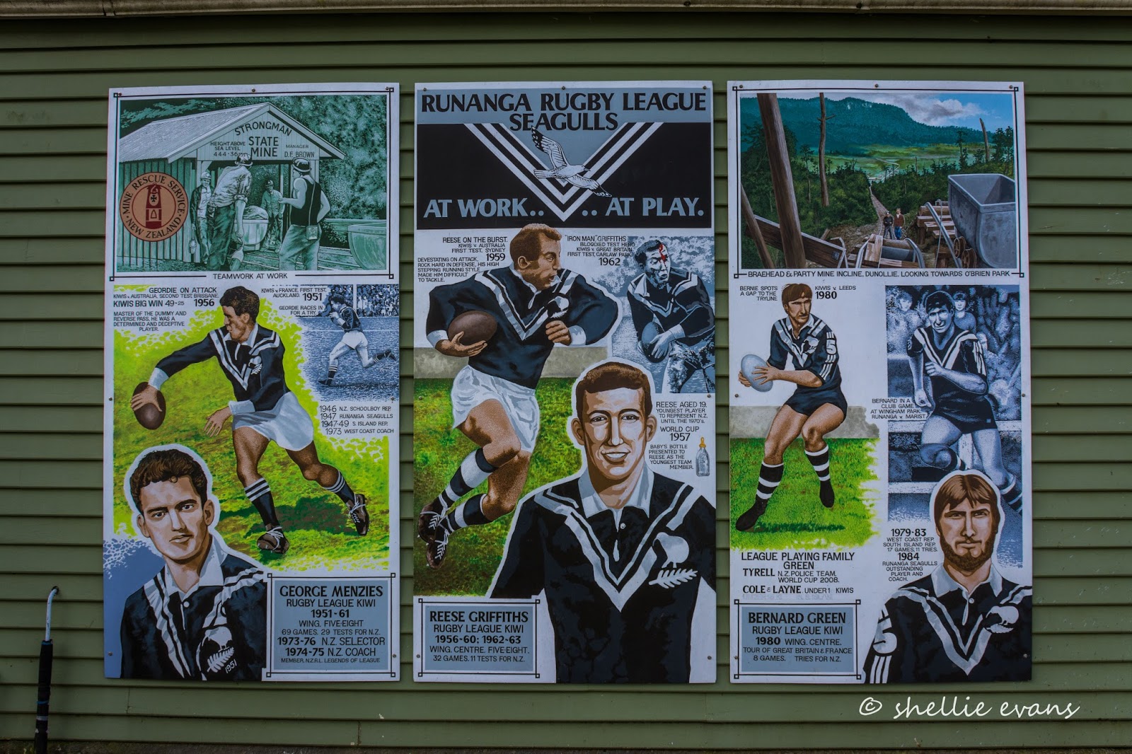
Runanga is also very proud of their mining heritage, rugby league roots and their international players; this large display was on the side of one of the shops.


Unfortunately the Buffalo Butchery didn't stand the test of time. I remember when we were on the Coast many years ago and had a buffalo burger at a cafe out in the middle of nowhere somewhere near Punakaiki. The cafe was actually at a buffalo farm (these are water buffalo), poor things, watching their mates being turned into burgers. It too had disappeared when we travelled that area last year.


While I was taking photos David decided that we'd have 'Chicken 'n Chips' for dinner from the local (the one and only) shop. It was rather surreal eating dinner at a picnic table on a footpath in a deserted and slightly rundown town.


But the 'Chicken 'n Chips'  were very tasty (hey, anything's tasty when you don't have to cook dinner) and we did see a few locals, mainly young people coming in for their daily fix; a packet of fags.


We carried on up the coast and checked out Motukiekie from the beach where I was going to walk in from. Hmmm....the tide looked like it still had a way to go and the sun had disappeared behind a thick band of grey cloud. 


We drove back to our secret track and headed down to the beach, finding the ladder just as it was the last time. 


The rocks came into view at the last turn in the track....that tide still looks a little high and the waves are still rolling in. And the sun has definitely disappeared.  


We swung down the rope (middle right) onto the rocks at the base of the cliffs...


...and walked up the beach to the rock stacks where unfortunately the tide was just not going to go out far enough tonight. It still blocked the way around the last section and the starfish pools were still covered in water. Oh well, it was worth a shot but we decided it just wasn't going to happen tonight so headed off back to the rope.


I caught a movement out of the corner of my eye and found this juvenile spotted shag trying desperately to blend into the rock-face behind him. He was actually warming himself in the sun that had finally appeared for a few brief moments...


...but he quickly decided he needed to find an escape route...


"If I tip-toe quietly this way, she won't notice me"


Meanwhile David had disappeared down the beach...


And while I was taking that shot, Master Shag made a quick escape.


As did we; back up the rocks, up the rope, the ladder and through the bush, back to the ute and home again...


...just in time to catch the sun setting!!