Showing posts with label otago rail trail. Show all posts

March 26, 2017

Macraes Giants- Otago; Part 1

Real-time

We went looking for giant lizards at Macraes Flat, instead we found a giant bird, a giant mine and a giant collection of pig skins!


We travelled through some new territory on the way to Macraes Flat, following the eastern end of the Otago Rail Trail which finishes (or starts, depending on which way you ride it) in Middlemarch. We stopped at the old Hyde Hotel where many bikers call in at the cafe for refreshments on their way through.


I also took the obligatory church photos (both now decommissioned) and one of the the old school, which is now a cyclists accommodation lodge.


A little further on we turn left and head up onto the rocky plateau ahead of us. We're on a bit of wild goose chase, one I don't hold out much hope in being successful in either. But we have all day ahead of us and nowhere we need to be in a hurry. And we have our home on the back, so we'll stop where and when the fancy takes us. 


We're looking for Grand Skinks and their slightly larger brothers the Otago Skink, they are New Zealand's largest lizard at 300mm (11 inches) long. They are very rare, very endangered and found only in three or four small areas in Otago, including in the Macraes Flat conservation area.


We've only ever seen them at Orokonui Ecosanctuary in Dunedin where they are successfully breeding- that's a young lizard riding on a parent's back with two juveniles on the rock below. The baby is about the size of the usual skinks people see in NZ.


I took these photos also at Orokonui- that's an adult top left and a baby bottom right and look how well camouflaged they are in the bush. You've probably guessed due to the lack of photos from elsewhere that we failed to find any skinks at Macraes Flat. Which actually isn't that surprising considering the fact that, in the end, we ran out of time and didn't even look! 


Here we are crossing the Taieri River for the upteenth time on our travels. This isn't surprising given that the river is 318km long and flows from the upper reaches of the Maniototo Valley, makes a dramatic U turn around the northern end of the Rock & Pillar Range and flows down through the Strath Taieri Valley (where we are) all the way to the ocean.


We've crossed back and forward over the Taieri River numerous times while exploring the Maniototo and Otago, we've been to the top in the Maniototo Valley and seen the Upper Taieri Scroll Plain where the river begins its journey (click to enlarge) and to the bottom, staying at Taieri Mouth not long after we started this journey and everywhere in between.


This beautiful old iron lattice truss bridge over the Taieri was built in 1879.


It was a long, slow and steady haul up onto the plateau where the views back over the valley to the Rock & Pillar Range behind were absolutely stunning. The Rock & Pillars rise to 1450m and are named for the impressive tors along the ridge. 


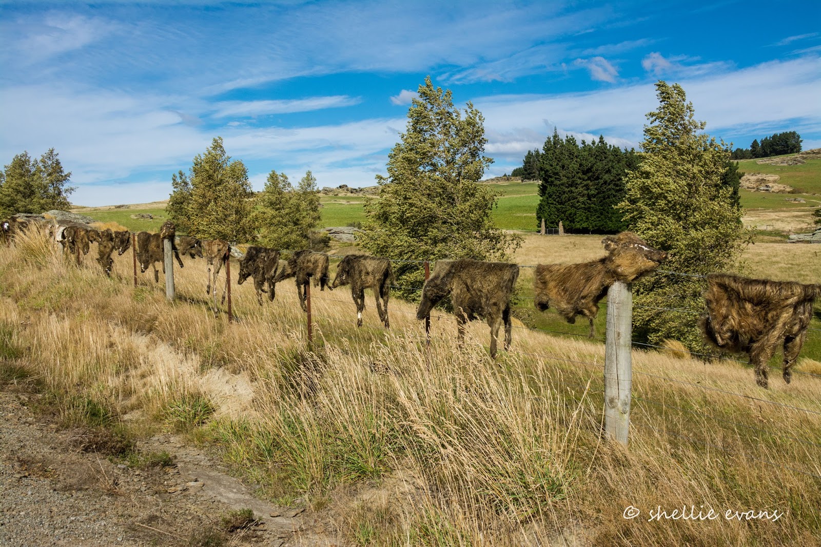
We pass many hundreds of tors on this side of the valley too, in fact we could still be in Central Otago as the landscape is so similar, and then travel on past farmland atop the Taieri Ridge. It took a few moments to register what we were seeing strung along the fenceline ahead of us as we passed here.  As far as the eye could see ahead... 


...and once we stopped, back behind us, at least a kilometre of animal skins! Collected over the past 20 years they are mostly wild pigs but deer, goat and wallaby skins are in there too, some complete with skulls. Eeuw!


There are many bizarre fences in New Zealand; Cadrona's famous bra fence, several shoe fences, a jandal (flip-flop) fence or two, bike fences, hubcap fences, number plate fences but now we've seen it all! No wussy collection here, this is a true Southern Man's fence! 

Further on, and as we drop down into the a huge basin of Macraes Flat, far across the valley we can see some terracing on the hills and steam rising from chimneys near what looks like a very large mine site (I've zoomed in here). I wonder if we'll get close...


Eventually we pull into the old gold mining settlement of Macraes (pop. 54). where there's neither sight nor sound of people about, even though it's a holiday Monday. In 2014 the settlement changed its name from Macraes Flat to Macraes so as to distinguish itself from the surrounding district.


We have lunch parked beside the old stables of the historic Stanley's Hotel (1882) which is across the road.


Stanley's Hotel was owned by Oceana Gold, the gold mining company that runs the nearby mine. In 2015 it was returned to the community in exchange for some impressive artwork....well one piece of impressive art, I'm not so sure about the others.


Located behind where we're parked is the Macrae Heritage & Arts Park and wetland, originally given to the community by the mine it has now been exchanged for the hotel, other heritage buildings, land and money. 


Eventually, I'm sure, the park will be given back to the community. I mean what's a gold mine going to do with a 9m high, 750kg big bird, a tussock planting and numerous large billboards (a very odd contribution if I must say so myself).


The bird on the other hand is a stunning sculpture and such a pity it's not seen by many people. You could drive straight through Macraes and not spot it, or even visit the settlement and not know of it tucked out the back.

With a 12m wingspan, it is of the long extinct Haast's Eagle, a bird that in reality weighed about 15kgs and had a wingspan of 3 metres. It was known to attack and eat moa, the sculpture is in attack mode here. As befitting a bird of this size the eagle was flown, beneath a helicopter, from sculptor Mark Hill's (son of jeweller Michael Hill) home in Arrowtown to Macraes in 2008. Now that would have been an impressive sight. 


This little dog's grave stone and plaque has been moved to near the entrance to the walkway around the wetland and sculpture park. What a sad little poem; David & I couldn't decide whether the driver ran back and forth over the dog until she died or just ran over her and killed her outright. Either way it was obviously a very traumatic time for her owner, and just before Christmas too.


I took a quick walk up the road to locate the local church, and as with many of NZ's abandoned or nearly abandoned country settlements, this is another church that has seen better days. This is the former St Patrick's Catholic Church, a Category 2 listed Historic Place building, now located in a horse paddock and in a sad state of disrepair.


To be continued... Part 2


September 18, 2015

Maniototo- Sanatorium & Cemetery; Part 1

After exploring the snow covered Kyeburn Diggings the day before, we headed off in the opposite direction this time, south over the vast & isolated Maniototo Plain.

Our first stop was going to be at Waipiata, an old railway town and another marker point for the Otago Rail Trail. But when I saw the Maniototo Sale Yards with its tiny grandstand we had to stop so I could take a photo.


And across the paddocks from the sale yards, nestled into the foothills of the Rock & Pillar Range, I can see a group of large buildings. This must be En Hakkore, a Christian Retreat which we’d be passing on our way along the valley.


Our next stop was Waipiata, a tiny, lonely little settlement in the middle of nowhere that was once called Komako (bellbird). A village that at one stage had at least two churches, both now converted into homes.


Another business long gone from Waipiata...


Unlike Wedderburn, the Rail Goods Shed at Waipiata (below) has yet to be restored. It’s cold and bleak and snow starts to fall as I walk along the road taking photos. I’m sure the pub would be busy during the cycling season, it’s just across the road from the trail and I bet it’s a business that has survived mainly due to the cycle trail.


We leave Waipiata crossing the historic ‘Green Bridge’ which was built in 1896 and is the only flood-free crossing of the Tairei River in Maniototo. I didn’t know the Tairei River started its course in the Maniototo and in fact we’ll be near it’s headwaters later in the day. It flows a very long way, tracking along the Rock & Pillar range heading north then around the end of the range and back along the east side before heading south-east towards the coast exiting south of Dunedin at Tairei Mouth, a place we stopped at for a few days way back when we started this adventure.


We head up into the foothills and approach an imposing group of buildings; the ones I saw from the saleyards. Now a Christian Retreat (En Hakkore) this settlement, built in 1914, was originally a private facility for the treatment of tuberculosis. The dry climate was considered a suitable cure for consumption- dry and bloody cold! It was taken over by the Government in the 1920s and continued as a Sanatorium until 1961.

After the Sanatorium closed it became a youth correction centre a.k.a. a borstal which closed in 1979. During a conversation with a local, elsewhere on our travels, he told me he remembers his parents threatening that he’d be ‘sent up the hill’ if he didn’t behave.


Permission is required (of course) to visit the buildings but people do regularly call and are shown around the complex, perhaps they are interested in the historical buildings or have a link to them via their or their families past. We had a lot of ground to cover during the day so only stopped at the gates.

The building below was across the road from the main complex and as large a building as it looks from this front view, it is actually the small end. The building stretches back behind perhaps double the length of the ones above, with rooms and verandas on both levels and both sides.


We carried on up the hill, we were on a mission to find Hamiltons, and in particular the historic Hamiltons Cemetery which, other than a dam and the scars from mining, is all that remains of another long ago Central Otago gold mining town that once had 4000 inhabitants. We took the Hamiltons Diggings Road, a ‘dry weather track’ that was covered in snow & mud. Hmmm….wrong move.

David was very reluctant but I insisted we’d just head to the first rise where the road disappeared because I was sure the cemetery must be up there somewhere and I'd walk the rest of the way. Hamiltons Diggings = Hamiltons Cemetery wouldn’t you think? It didn’t take long for us to start slipping and sliding and David to be cursing. With nowhere to turn around we had to head to the rise where the track opened up a bit before we could safely turn. David was not a happy chap but I did manage to see what was on the other side of the bank where we turned; the old gold mining dam, but no cemetery.


I thought I’d missed the cemetery as it was probably further up the range on one of the knobbly hills I could see and I’d have to come back in the summer, but back on the ‘main’ road and around the very next bend was the cemetery signpost and a track leading down to it! I won't tell you what David said as he surveyed the mud filled tires and especially the mud caked under the wheel arches. "But darling" I said, "that's why we have a 4WD and a ute so we can explore off the beaten track." Again, I won't tell you what he said.


The reason I thought it was on one of the hills was from photos that I had seen of the amazing panoramic view out over the Maniototo Plain from the cemetery. Unfortunately for me the weather wasn’t that great and the view a bit hazy with a lot of low cloud and snow showers sweeping through.


Hamiltons Cemetery has been restored  and a Memorial Plaque stands near the entrance remembering those that have been buried here. The earliest being 33yr old John Black French who died in 1865.


It doesn’t look it, but it’s bitterly cold up here, an ice cold wind is blowing fiercely and snow flurries are passing through as I wander around the graveyard. David only makes it to the gate before he makes a hasty retreat back to the warmth of the ute.


I finish taking a few photos and would have liked to have lingered longer reading the headstones and taking in the views but for the first time this winter, the cold gets to me too; my fingers, nose, ears and toes are about to drop off and I scurry back to the ute also.


We head off with the heater on full blast and soon warm up. The road drops back down onto the lower slopes…..


…and goes on and on forever. It’s more clay and mud than gravel and we feel like we’re driving through a farm not on a public road. And I think the farmers must think of the roads as theirs as well, they’re littered with animal poop, mounds of hay & silage and deep tractor tire ruts in places. That’s more snow flurries in the bottom left photo. We haven’t picked the best day to explore.


The next settlement is Patearoa where other than the obligatory country pub and church there’s not too many more houses. And once again we are by ourselves, the Maniototo with it’s big skies and wide open spaces is also a place of solitude.


Patearoa was once known as Sowburn part of Thomson's Barnyard (named by our mate John Turnbull Thomson) and once serviced gold miners. The remnants of a Chinese mining settlement can be seen near a walkway that runs along the Sowburn Creek. Due to the weather, the walk held little appeal to us so we passed through the village heading on towards the sharp end of the valley.


To be continued……Part 2


August 27, 2015

Art Deco Town & ‘Thomsons Barnyard’

We left St Bathans Domain on a very bleak and overcast morning with rain threatening. David was less keen to leave, he’d cleaned the vehicles and if it did rain while we were on the road all his hard work would be undone. We took the long route back to the main road to avoid the muddy gravel road just past St Bathans settlement. It didn’t help our case, the rain started before we reached the turnoff and we drove through to Ranfurly in a steady downpour.

Needless to say I didn’t take these photos of the iconic Webberburn Goods Shed on our way past, we drove back there on a fine day. Once again the 1975 Graham Sydney painting “July on the Maniototo”, made this goods shed famous.


After the closure of the Otago Central Railway line, the goods shed was moved 5km away to an open cast coal mine at the head of the Ida Valley. It eventually became home to feral pigeons. When the Rail Trail began the community was keen to see the old building put back in its original place. In 2002 it was returned on the back of a truck and restored to its original green colour (it had been painted red). It is now an icon of the Trail and the Maniototo – and it is still home to the pigeons.

The original small Wedderburn Station, built in 1900, was also recovered and restored to its original home (a curling club had moved it 300m to the west). This is the last remaining Vogel Class 5 Station and ticket office in New Zealand, with a simple lean-to design.


Just up the road from the goods shed is the historic Wedderburn Tavern, built in 1885. Once the a stop-over for coaches and wagons, it is now a favourite destination and half way point for cyclists on the Rail Trail.


Our next camping site was at the Ranfurly Holiday Park, it was time to plug back into the grid and give the generator a bit of a break. We are very power hungry couple (well David will say it’s just me) but the truth is we both use a lot of power in various forms and while we do quite adequately cope with our solar panels and generator it’s just nice to sometimes plug in and not worry about turning off the extra lights, watching TV a little later, leaving the computer running between jobs or using the toaster & the microwave (both out of bounds when off the grid). Then there are the long hot showers we can have, although they're usually outweighed by the bitter cold run across to the ablution block. We also had laundry to do, and there aren’t too many freedom camping spots in the area.


Ranfurly is known as the rural Art Deco town and is the smaller (much smaller) Art Deco sister to my home town Napier, the Art Deco Capital of the world (that link will take you to my blog on the Art Deco Weekend in Napier, there are more Art Deco posts out in the menu on the right). Ranfurly also has a popular art deco festival that attracts people from far and wide and I was looking forward to comparing notes.


Following a series of disastrous and suspicious fires in the 1930′s that destroyed many of Ranfurly’s buildings, including the town hall and the hotel, the fashionable, inexpensive and simplistic Art Deco style was introduced to Ranfurly to replace many of the towns buildings.


The Centennial Milk Bar is the iconic art deco building in Ranfurly. It is located beside the I-Site (once the Railway Station) in the main street and in its heyday it was a bustling place serving hungry passengers from the trains and afternoon teas and icecreams to the locals. By the mid 1970’s the trains had stopped running, the town’s already small population had dwindled and the milk bar was abandoned & rundown. The only interest in the prominent but derelict art deco building on the main street was from the local fire brigade who were looking for something to burn down for a practice exercise.


After the economic decline of the 1990′s, the local community was thinking of ways to attract people to Ranfurly and came up with the idea of reviving the forty-odd art deco buildings located throughout the town to create an ‘Art Deco’ theme for Ranfurly. In 2000 the Central Otago District Council purchased the Centennial Milk Bar and leased it to the town’s Art Deco Society who set it up as an Art Deco Gallery. Local families have lent or donated their treasures and the displays, set up as rooms; bring to life the glamour and glitz of the era- it was closed while we were in town.

Street art and murals reflecting the Art Deco era are attached or painted on a number of the buildings along the main street, some are subtly placed so that unless you’re specifically looking for them, they can easily be missed.


The former Railway Station and now the i-Site (information centre) taken before and after the snow fall we had while we were in Ranfurly.


To be fair, we did visit Ranfurly in the middle of winter, but some days when I went walkabout it felt like I was the only person in an abandoned town, a few tumbleweeds rolling down the main street would have completed the picture.

More Ranfurly buildings…


The restored Fenton Library (1926) building houses Ranfurly’s own home grown community trust radio station ‘Burn 729am’. I was searching for a radio station in the early hours of our first morning in Ranfurly and came up with just one station loud and clear. Music was playing for awhile and then the most softly spoken boring monotonous voice I have ever heard came on, he prattled on for ages before playing the next track. I thought to myself, it must be hard to get decent announcers in Central Otago and they’ve given him the grave-yard shift so he doesn’t scare the punters away.

It wasn’t until I went for a walk in the morning that I realised I was listening to Burn 729 out of this building just a few steps away from where I was trying to go to sleep. You can see the campground in the background. I just know the guy sitting outside & nodding off in the sun, with a fag in one hand & a coffee in the other, was my man.


I loved the simplicity of the butchers shop just a little further down the road, right down to the huge home-kill cattle carcass they were man-handling out of the small truck and into the shop. You’d never see that in the city, someone would report them for animal cruelty.  No fancy meats here either; eggs, sausages & steak (where are the chips), hearty meals for the hard working rural folk.


And I bet you’ve been wondering when I was going to mention, ‘Thomson’s Barnyard’. On the corner of the main street opposite the Centennial Milk Bar stands the figure of a man looking through a theodolite. This is the memorial to John Turnbull Thomson, he emigrated to New Zealand in 1856 and worked as Chief Surveyor of the Otago Province, surveying and exploring large sections of the interior. One man on a mission, he virtually shaped Central and North Otago. He later became Surveyor-General of New Zealand.


Many names in the area can be attributed to Thomson's Northumbrian background and are often in the form of a Northumbrian dialectic name for an animal including Ranfurly which he originally named Eweburn.  Names such as Horseburn, Mareburn, Fillyburn, Hogburn, Houndburn, Sowburn and Swinburn were given to streams in the area. Then there’s the Horse Range & the Pigroot. The Kyeburn (cow), Gimmerburn (hogget), Stotburn (steer), and Wedderburn (wether) settlements were all named by Thomson, hence the reason that occasionally the area is referred to as “Thomson’s Barnyard”. Perhaps he'd have been better having the name McDonald.

He certainly wandered far and wide, maybe the fact that he had nine daughters had something to do with having to get out of the house. Once he was appointed Surveyor-General he covered most of New Zealand introducing his more accurate method of triangulation survey, using true bearings rather than compass bearings to survey the country.


And finally, to book-end the post with another Rail Trail Goods Shed, the Ranfurly Goods Shed after the snow fall.