Well, here we are back in the land of the living, we're now parked up at the NZMCA Park at Franz Josef after a brilliantly sunny eight days on the West Coast. We really timed that right, our intensive weather watching finally paid off.

Although this was just 12hrs later and it's been bucketing down for the last 36hrs. We could fill all our water containers and tanks 100 times over and still have some spare. We'll sit it out here for the next few days while we wait for the rain to ease and keep our chins up, by telling ourselves, "you can't have a rainforest without rain".
We managed to fit in the Fox Glacier walk and Lake Matheson before the weather broke but there are still a number of walks here in Franz to do before we move on.

We had a bit of drama a couple of days ago when we had our very first puncture after 48,000km and 3 years of travel. But it couldn't have happened in a more picturesque place. Look at that backdrop, Mt Cook from the Lake Matheson carpark near Fox Glacier. Luckily David managed to change it without having to take the 5th-wheeler off the back although it was hard work, it all went well. It was the 40 minutes we spent hunting for the ignition key afterwards that did us in!

I'll be back to do the blogs on the West Coast soon. We've had an awesome time and have thoroughly enjoyed exploring the Coast so far, especially south of Haast.
Back to the canals at Twizel, and a few photos to send us on our way to the Coast. The days got colder and more spectacular as the snow crept lower on the surrounding ranges. It never made it down to our level like it did last year. It was also great to not have too many vans in the park, only a few tough and hardy movanners. And it was a lovely surprise to see Jeff & Miriam pull in again, that's them on the left. Both of us, buggers for punishment. We met them at the canals around the same time last year.

Although the top toughie award must go to this guy in his mobile man cave parked across the canal from us. He stayed for a couple of nights in the freezing cold with no heating that I could see, and possibly no fish that I saw either. That is dedication.

I made my regular pilgrimage to the top of the hill behind the camp to capture the 360 degree view, but this time I willed myself out of bed before day-break, wrapped up warm in the -5c frost that was settling on the ground and was rewarded with the most spectacular sunrise.

Snow had fallen even lower overnight on the Ben Ohau Range.

On the day before we left the canals, David went fishing (again) and I went off to explore Wairepo Arm, a small lake that sits off to the side of the canal opposite where we were parked. I was hoping for a few more bird sightings than I saw; the usual scaups (diving ducks), a few Grey Warblers and this cute little fellow, my favourite high country lake bird; a juvenile Australasian Crested Grebe. He ducked and dived all the way up the side of the lake. I ran ahead of him a number of times to hide behind the toi toi on the edge so I could catch him when he come in close. We gave each other a fright more than once. He was a very fast swimmer under water and beat me to my spot a few times.
The sculpture in the bottom photo sits on a small island in the middle of the lake.
The middle photo shows the new face of the MacKenzie Country, and not one that sits well with a lot of people either. Hydro power has been joined by the pivot irrigators of the dairy conversions.

After a walk around the lake I spotted David fishing out on the point, I decided the van looked a warmer option and headed in that direction. The temperature dropped dramatically as soon as the sun disappeared behind the clouds.

We left the canals on another cold, clear, blue sky day, waiting until late morning for the snow and ice to turn to slush before crossing Lindis Pass. There actually wasn't too much snow around the summit although the carpark was full of hire motorhomes and people having fun; building snowmen and throwing snow balls around. The range in the distance looked good enough to eat, the snow thick and white, like icing on a cake.

We stopped for a late lunch near the Luggate Bridge over the Clutha River, this time in a gravel pit at the top of the rise instead of at the bottom as we did on our way past by last week. I hadn't realised that you could see the historic bridge from this angle, what a pity, I could have come here when I was doing my autumn colour tiki-tour around Wanaka. Added to my list for next time!
It was getting late by the time we headed west along Lake Hawea, with just enough light to get a good panoramic photo of the lake from the lookout.

There were a few times over summer when we had in mind to stay at the Kidd Bush Reserve DOC camp at the top of the lake (hidden on the shoreline beneath the mountains on the far left above) but it didn't eventuate. It was far too cold to stop now and we weren't even sure if the camp would be open (it closes over winter and for lambing), and we were heading to Makarora for the night.
But I wanted to check it out for the next time we were in the area so I've added it in here to keep it in sequence. We came back up the road the next day exploring, this is the view looking towards Lake Hawea at The Neck, a small piece of land between Lake Wanaka & Lake Hawea. We're heading to Kidds Bush which is around the corner on the top left.

As soon as we turn onto the gravel track the sun disappears behind us and we can see frost and ice laying on the road side and ahead of us around the trees.

The road is open all the way to the reserve but what a surprise awaits us, we're looking for a bit of sun to have a cup of tea but all we find is a campground covered in thick frost.
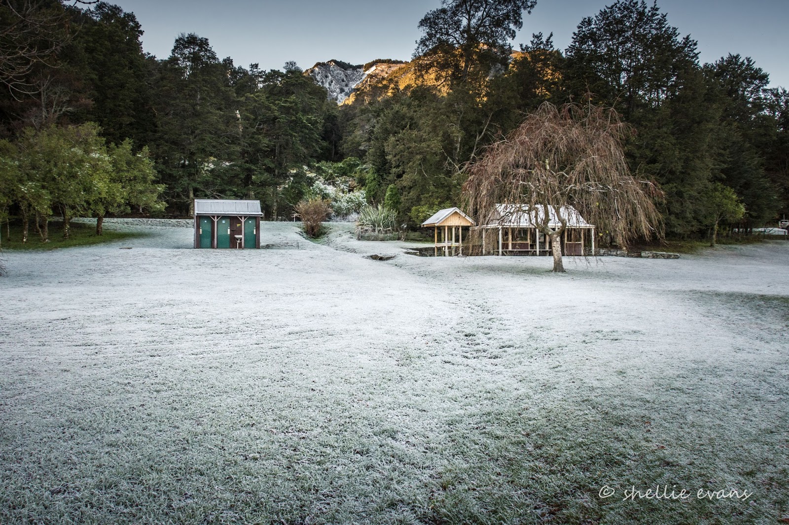
The reserve hasn't seen the sun for days, it's tucked in under some very tall mountains behind and the sun disappears over more mountains at the far end, without it reaching back here. We won't be having a cuppa at that table.

And it looks like I've finally found my elusive hoar frost, even if it is just a mini one. It was bitterly cold outside and I wonder how many tourists, in their hire vans, drive the 6km gravel and dirt track to arrive at this frozen landscape for the night. They'd be bitterly disappointed and I bet not many would stay, especially the small sleeper vans with no heating. We couldn't wait to get out of there.

We drove on to the end of the public road looking for a patch of sun for our cuppa, we found it at the end of the road right before it crossed a cattle stop into the high country Hunter Valley Station with this magnificent woolshed beside the gate.
Kidds Bush will just have to wait until the height of summer before we'll be back to stay.

Back to our journey from the canals to Makarora. Once through The Neck we pulled into a lookout over Lake Wanaka. I can see Mou Waho Island in the centre at the far end. That's the island we visited in the Takacat from Glendhu Bay, 'an island on a lake in an island on a lake....", you get the picture, click on the link above to see more.

Then it's off along the edge of Lake Wanaka, the road winding it's way in and out, up and down, right along the shoreline, with stunning scenery out to the left and snow capped mountains above.

Until we finally reach our destination for the next couple of nights; the Makarora Country Cafe & Campervan Park.

It's also a NZMCA CAP(cost applies park) and we are the only ones in for the night. Which isn't surprising given that we're the only mad people out 'camping' in this cold. The first morning we had a -5c frost. We haven't been leaving the heater on overnight because we've been toasty warm with the winter duvet and electric blanket (when we have power) but I'd have to say that the 2c in the van when we wake up, is a little too cold for comfort.

The following morning is was -7c outside when I woke and it dropped to -9c before the sun appeared over the hedge to warm our cockles. And look what happened to the 'drip, drip' in the night! Nature is so cool....literally.

And an added bonus to our Makarora stay was the NZ Falcon/Karearea that came to rest in this tree behind our van both mornings. Another sighting, in fact there were two birds in this group of trees, probably a pair. Can you see him (or her)? The little black dot on the right at the very top of the tree (click photo to enlarge). This is our 4th (and 5th) sighting of a falcon in 3 weeks.

Here he is, I've zoomed in for you (if only I had that 600mm).


Makarora was a great place to stop at, it allowed us to explore the top end of Haast Pass and we had a site with power to return to at the end of the day. Which was just as well, given the freezing temperatures we experienced. Sunny days are great in the mountains, but they come with their downside too; very frosty mornings! At least the cafe's roaring fire, hot coffee & carrot cake went down a treat.


